AP TET Exam  >  AP TET Tests  >  APSET Mock Test Series 2025  >  APSET Paper 2 Mock Test - 10 (Geography) - AP TET MCQ

APSET Paper 2 Mock Test - 10 (Geography) - AP TET MCQ


Test Description

30 Questions MCQ Test APSET Mock Test Series 2025 - APSET Paper 2 Mock Test - 10 (Geography)

APSET Paper 2 Mock Test - 10 (Geography) for AP TET 2024 is part of APSET Mock Test Series 2025 preparation. The APSET Paper 2 Mock Test - 10 (Geography) questions and answers have been prepared according to the AP TET exam syllabus.The APSET Paper 2 Mock Test - 10 (Geography) MCQs are made for AP TET 2024 Exam. Find important definitions, questions, notes, meanings, examples, exercises, MCQs and online tests for APSET Paper 2 Mock Test - 10 (Geography) below.
Solutions of APSET Paper 2 Mock Test - 10 (Geography) questions in English are available as part of our APSET Mock Test Series 2025 for AP TET & APSET Paper 2 Mock Test - 10 (Geography) solutions in Hindi for APSET Mock Test Series 2025 course. Download more important topics, notes, lectures and mock test series for AP TET Exam by signing up for free. Attempt APSET Paper 2 Mock Test - 10 (Geography) | 100 questions in 120 minutes | Mock test for AP TET preparation | Free important questions MCQ to study APSET Mock Test Series 2025 for AP TET Exam | Download free PDF with solutions
APSET Paper 2 Mock Test - 10 (Geography) - Question 1

Globigerina ooze is

Detailed Solution for APSET Paper 2 Mock Test - 10 (Geography) - Question 1

The Correct Answer is Pelagic deposit.​

Key Points

  • This Globigerina ooze is the most densely spread of the oozes which occur both in the Atlantic and in the Indian oceans. While Pteropod ooze is found in the middle of the Atlantic.
  • globigerina ooze a layer of soft mud made up in large part of the shells of dead globigerina and covering great areas of the sea bottom at depths of 1000 to 3000 feet.
  • globigerina ooze formed
    • Globigerina ooze Deep-sea ooze in which at least 30% of the sediment consists of planktonic Foraminiferida, including chiefly Globigerina.
    • It is the most widespread deposit to form from the settling out of material from overlying waters, covering almost 50% of the deep-sea floor.

APSET Paper 2 Mock Test - 10 (Geography) - Question 2

“Whatever the men do in their own environment, they cannot completely get rid of themselves completely." - Who said this?

Detailed Solution for APSET Paper 2 Mock Test - 10 (Geography) - Question 2

Correct Answer: Lucien Febvre.

Key Points

  • In the twentieth century, possibilism got Stronghold after the publication of Blache’s article in 1913 where he categorically states that geography as a discipline seeks to measure and role of man in modifying the earth’s surface.
  • This was further strengthened when his book was published in 1921 (English translation in 1926), though posthumously.
  • He observes that nature gives man materials that have their inherent needs as well as limitations thus leading them to limited uses.
  • Possibilism was further flourished by acclaimed historian Lucien Febvre(1878-1956).
  • He puts forward “Whatever the men do in their own environment, they cannot completely rid of themselves completely”.
  • Febvre emphasized human initiative and motivation against the environment, destroying the environmental deterministic reasoning and as part of the environment of any group, as well as other humans, because they belong to the next group's cultural surroundings or the constraints of the environment are influenced by such thinking,
  • He stated that in the view of possibilists, a homogeneous region does not necessarily result in a homogeneous society.
  • This is because people residing in any area have the choice of possibilities from time to time and also in the quantity they want.

Additional Information

  • The movement from a state of necessity to a state of freedom creates possibilities with resources obtained from the environment.
  • For example, Nature provides opportunities and human beings make use of these opportunities by creating their imprints everywhere. Concept: Nature of Human Geography.
  • The term Possibilism means that the environment only limits the number of choices that a person has.
  • At its heart, possibilism follows the notion that humans have commanding power over their environment, albeit within certain limits.
1 Crore+ students have signed up on EduRev. Have you? Download the App
APSET Paper 2 Mock Test - 10 (Geography) - Question 3

Which port was developed as a satellite port of Mumbai Port?

Detailed Solution for APSET Paper 2 Mock Test - 10 (Geography) - Question 3

The correct answer is Jawaharlal Nehru Port.

Key Points

  • Jawaharlal Nehru Port:
    • Jawaharlal Nehru Port was developed as a satellite port of Mumbai Port.
    • Jawaharlal Nehru Port at Nhava Sheva was developed as a satellite port to relieve the pressure at the Mumbai port.
    • It is the largest container port in India.
    • It is located in Mumbai, in the state of Maharashtra.
    • JNPT handles the majority of India's containerized trade and is the focal point of long-haul calls to and from the emerging market economy.

Additional Information

  • Marmagao Port: Marmagao Port, situated at the entrance of the Zuari estuary, is a natural harbour in Goa.
  • Kandla Port: situated at the head of the Gulf of Kuchchh has been developed as a major port to cater to the needs of western and northwestern parts of the country and also to reduce the pressure at Mumbai port.
  • New Mangalore Port: It is located in the state of Karnataka and caters to the needs of the export of iron-ore and iron concentrates.
APSET Paper 2 Mock Test - 10 (Geography) - Question 4

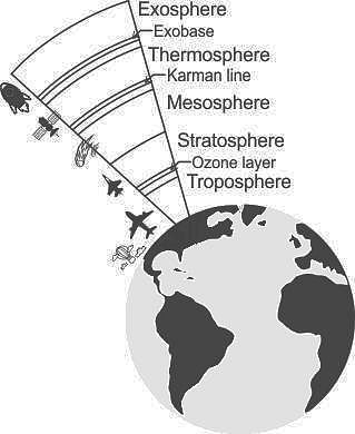
In which layer the maximum part of the atmosphere (by mass) is found?

Detailed Solution for APSET Paper 2 Mock Test - 10 (Geography) - Question 4

The Correct Answer is Troposphere.

Key Points

  • Troposphere
    • The troposphere is the lowest portion of Earth’s atmosphere and contains approximately 80% of the atmosphere’s mass and 99% of its water vapor and aerosols.
    • The average depth of the troposphere is approximately 17 km in the middle latitudes.
    • The characteristic features of the Troposphere are its great density.
    • In addition to nitrogen and oxygen, carbon dioxide, and water vapor (nearly all of the water vapor contained in the atmosphere is concentrated in the troposphere) and numerous particles of various origin
    • It thickness of the Troposphere is maximum at the equator, deeper in the tropics, up to 20 km, and shallower near the polar regions, at 7 km in summer, and indistinct in winter.
    • In India, it is taken to be around 16 Kilometers.
    • The thickness of the troposphere and consequently the atmosphere is maximum at the equator.
    • Almost all clouds are found in the troposphere.

Additional Information

  • Stratosphere
    • It is the second layer of the atmosphere found above the troposphere.
    • It extends up to 50 km in height.
    • This layer is very dry as it contains little water vapour.
    • This layer provides some advantages for flight because it is above stormy weather and has steady, strong, horizontal winds.
    • The ozone layer is found in this layer.
    • The ozone layer absorbs UV rays and safeguards the earth from harmful radiation.
    • Stratopause separates Stratosphere and Mesosphere.
  • Mesosphere
    • It is the coldest of the atmospheric layers.
    • The mesosphere starts at 50 km above the surface of Earth and goes up to 85 km.
    • The temperature drops with altitude in this layer.
    • By 80 km it reaches -100 degrees Celsius.
    • Meteors burn up in this layer.
    • Mesopause separates Mesosphere and Thermosphere.
  • Thermosphere
    • This layer is found above Mesopause from 80 to 400 km.
    • Radio waves that are transmitted from the earth are reflected by this layer.
    • The temperature increases with height.
    • Satellites occur in this layer.
  • Exosphere
    • It is the outermost layer of the atmosphere.
    • The zone where molecules and atoms escape into space is mentioned as the exosphere.
    • It extends from the top of the thermosphere up to 10,000 km.

APSET Paper 2 Mock Test - 10 (Geography) - Question 5
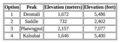
Which among the following is the highest peak of Andaman and Nicobar Islands?
Detailed Solution for APSET Paper 2 Mock Test - 10 (Geography) - Question 5

The correct answer is option 2 Saddle.

Key Points

  • The highest peak of the Andaman and Nicobar Islands is Saddle.
  • The saddle has an elevation of approximately 732 meters (2,402 feet) above sea level.
  • Located on North Andaman Island, Saddle is the highest point in the entire archipelago.
  • It is a part of the Great Nicobar Biosphere Reserve, which is known for its rich biodiversity.
  • The saddle offers stunning views of the surrounding landscapes and is a popular destination for trekkers and nature enthusiasts.

Additional Information

  • Deomali: Deomali is the highest peak in the Indian state of Odisha, not in the Andaman and Nicobar Islands.
  • Phawngpui: Phawngpui, also known as Blue Mountain, is the highest peak in the state of Mizoram, not in the Andaman and Nicobar Islands.
APSET Paper 2 Mock Test - 10 (Geography) - Question 6
What is the average temperature of the oceanic water at the surface?
Detailed Solution for APSET Paper 2 Mock Test - 10 (Geography) - Question 6

The top layer of the ocean is called as surface layer. The sun heats the water in the surface layer and thus the temperature of the surface layer is higher than the lower layers. The average temperature at the surface is 170 C. This temperature also varies in polar and equatorial areas.

APSET Paper 2 Mock Test - 10 (Geography) - Question 7

The highest per capita emitter of Carbon dioxide in the world is :

Detailed Solution for APSET Paper 2 Mock Test - 10 (Geography) - Question 7

The highest per capita emitter of Carbon dioxide in the world is Qatar. The biggest absolute emissions come from China and the United States. In terms of CO2 emissions per capita, China is ranked only ranked 47th, at 7.5 metric tonnes per capita. The US is ranked 11th at 16.5 per capita and amongst countries with sizeable populations, has the highest CO2 emissions per capita.

APSET Paper 2 Mock Test - 10 (Geography) - Question 8
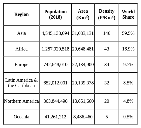
Which of the following Regions has the highest population density?
Detailed Solution for APSET Paper 2 Mock Test - 10 (Geography) - Question 8
APSET Paper 2 Mock Test - 10 (Geography) - Question 9
Which of the human made resource have huge economic importance?
Detailed Solution for APSET Paper 2 Mock Test - 10 (Geography) - Question 9

Key PointsHuman Made Resources:

  • Human-made resources, also known as capital resources, are material riches created by humans that can be used to create more wealth.
  • Examples include money, factories, roads, and technology.
  • Man-made resources are important because they can be conserved for the future and are produced by using skill, knowledge, and technology at their best.
  • Man-made resources are the signs of progress and development and are the refined form of natural resources.

Technological resources are the backbone of engineering and technology. It is a kind of human-made resource that has huge economic importance in innovation and development procedures. Educational quality, skill, and efficiency are human resources, not human-made resources.

Additional Information

Human Resources:

  • Human Resource refers to the number (quantity) and abilities (mental and physical) of people.
  • Though there are differing views regarding the treatment of humans as a resource, one cannot deny the fact that it is the skills of humans that help in transferring the physical material into a valuable resource.
  • The term human resources refer to the size of the population of a country along with its efficiency, educational qualities, productivity, organizational abilities, and farsightedness.
  • It is the ultimate resource, but not equally, distributed over the world.
APSET Paper 2 Mock Test - 10 (Geography) - Question 10
Which of the following methods may be used to input paper maps into a GIS?
Detailed Solution for APSET Paper 2 Mock Test - 10 (Geography) - Question 10

The correct option is (3)

Concept:-

Scanning, Manual digitizing and Automatic digitizing are the methods may be used to input paper maps into a GIS.

Key Points

  • Paper maps are static depictions of land features as they existed at the time they were made.
  • A digitising tablet, which is a manual pointing device that creates an equivalent vector map on the computer screen, specifying the vertices, points, line data, and so on, is used to manually digitise directly over the raster.
  • GIS was created as an enhancement to the usage and analysis of traditional paper maps.
  • A geographic information system (GIS) is a computer programme that captures, stores, checks, and displays data about locations on the Earth's surface.
  • In a GIS, digitising is the process of converting coordinates from a map, photograph, or other source of data into a digital format.
  • Scanning is the process of converting paper maps into a digital format that can be read by a computer. It's used to turn an analogue map into a scanned file, which is then traced into vector format.
APSET Paper 2 Mock Test - 10 (Geography) - Question 11

Given below are two statements, one labelled as assertion(A) and other labelled as reason(R).

Assertion(A)- Aerial photographs are more useful when spatial detail is more critical than spectral information.

Reason(R)- Aerial photograph’s spectral resolution is generally coarse.

Detailed Solution for APSET Paper 2 Mock Test - 10 (Geography) - Question 11

Aerial photographs are most useful when fine spatial detail s more critical than spectral information, as their spectral resolution is generally coarse when compared to data captured with electronic sensing devices. The geometry of vertical devices is well understood and it is possible to make very accurate measurements from them.

APSET Paper 2 Mock Test - 10 (Geography) - Question 12
Which one of the following is a major plate?
Detailed Solution for APSET Paper 2 Mock Test - 10 (Geography) - Question 12

The correct answer is option 4.

Key Points

Tectonic Plates:

  • A tectonic plate (also called a lithospheric plate) is a massive, irregularly-shaped slab of solid rock, generally composed of both continental and oceanic lithosphere.
  • A tectonic plate may be a continental plate or an oceanic plate, depending on which of the two occupies the larger portion of the plate.

The Major and Minor Plates: The Earth’s lithosphere is divided into seven major and some minor plates.

  • Young Fold Mountain ridges, oceanic trenches, and/or transform faults surround the major plates. These include:
    • The Antarctic (and the surrounding oceanic) plate. Hence, option 4 is correct.
    • The North American plate (with the western Atlantic floor separated from the South American plate along the Caribbean islands)
    • The South American plate (with the western Atlantic floor separated from the North American plate along the Caribbean islands)
    • The Pacific plate
    • The India-Australia-New Zealand plate
    • Africa with the eastern Atlantic floor plate
    • Eurasia and the adjacent oceanic plate
  • Some important minor plates include:
    • Cocos plate: Between Central America and the Pacific plate
    • Nazca plate: Between South America and the Pacific plate
    • Arabian plate: Mostly the Saudi Arabian landmass
    • Philippine plate: Between the Asiatic and Pacific plate
    • Caroline plate: Between the Philippine and Indian plates (North of New Guinea)
    • Fuji plate: North-east of Australia
    • Juan De Fuca plate: South-East of North American Plate. Hence, options 1, 2 and 3 are not correct.


APSET Paper 2 Mock Test - 10 (Geography) - Question 13

Which of the following is the cause of tides?

A. Moon's gravitational pull

B. Sun's gravitational pull

C. Centrifugal force

D. Gravitational pull of Earth

Select the answer from the codes given below :

Detailed Solution for APSET Paper 2 Mock Test - 10 (Geography) - Question 13

The correct answer is A, B and C.

Key Points

  • Tides are the periodic rise and fall of the sea level, once or twice a day.
  • Tides are caused by the earth-moon-sun positions.
  • They are caused by the gravitational forces exerted on the earth by the moon, and to a lesser extent, the sun.
  • Causes of tides are:
    • Sun's gravitational pull
    • Moon's gravitational pull
    • Centrifugal force
  • Centrifugal force is the force that acts to counter balance the gravity.
  • Tides vary in their frequency, direction and movement from place to place and also from time to time.

Thus, we can say that the moon's gravitational pull, the sun's gravitational pull and the centrifugal force are causes of tides.

APSET Paper 2 Mock Test - 10 (Geography) - Question 14
Which of the following question(s) may be best answered using a GIS?
Detailed Solution for APSET Paper 2 Mock Test - 10 (Geography) - Question 14

The correct answer is option 4.

Concept:

Geographic information system:

A geographic information system (GIS) is a computer system that generates, maintains, analyses, and maps various data types. GIS links data to a map by combining location data (where objects are) with several forms of descriptive data. This lays the groundwork for mapping and analysis used in science and almost every industry. GIS assists users in comprehending patterns, connections, and spatial context.

Explanation:

Some of the question(s) may be best answered using a GIS:

  • What is at a particular location?
  • Where do certain conditions apply?
  • What has changed since the trends?
  • Where is a particular feature found?
  • What geographical patterns exist?

Hence the correct answer is All options are correct.

APSET Paper 2 Mock Test - 10 (Geography) - Question 15

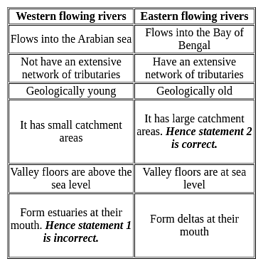
With reference to the Peninsular drainage system consider the following statements?

1. Western flowing Peninsular rivers form deltas at their mouth.

2. Eastern flowing river has the larger catchment areas and valley floors are at sea level.

Which of the statements given above is/are correct?

Detailed Solution for APSET Paper 2 Mock Test - 10 (Geography) - Question 15

The correct answer is 3 only.

Key Points Peninsular Drainage System

  • The peninsular drainage system is older than the Himalayan drainage system.
  • The peninsular rivers are devoid of meanders and almost have a fixed course.
  • They carry less amount of water compared to the Himalayan river and are dry during the summer season.
  • The drainage basins of the peninsular are comparatively smaller in size compared to the Himalayan Rivers.
  • The Mahanadi, Godavari, Krishna, Cauvery and other rivers drain (eastward) into the Bay of Bengal.
  • The Narmada and Tapi river flow (westward) into the Arabian sea.
APSET Paper 2 Mock Test - 10 (Geography) - Question 16
Match the following:-

Detailed Solution for APSET Paper 2 Mock Test - 10 (Geography) - Question 16

The bhabar lies along the foothills of the Shivalik from the Indus river to the Tista. It consists of pebble-studded rocks in the shape of porous beds and due to the porosity of this zone all the stream disappears here.

The Bhangar is not much suitable for cultivation due to the presence of older alluvium and it forms the alluvial terrace above the level of flood plains. One major characteristic of bhangar is that it is impregnated with calcareous deposits, Kankar.

The Tarai is situated to the south of the Bhabar and has alluvium deposits that are much finer than that present in bhabar. It is an area of excessive dampness. Most of the Tarai land has been reclaimed for agriculture.

The khadar represents the flood plain with newer alluvium. The khadar is characterised by clay and fertile soil and as a result intensive agriculture is practiced here.

APSET Paper 2 Mock Test - 10 (Geography) - Question 17
Which union territory of India had the lowest sex ratio in 2011?
Detailed Solution for APSET Paper 2 Mock Test - 10 (Geography) - Question 17

The correct answer is Daman and Diu.

Key Points 

  • The Sex ratio is used to describe the number of females per 1000 males.
  • It is a valuable source for finding the population of women in India and what is the ratio of women to that of men in India.
  • In the Population Census of 2011, it was revealed that the population ratio in India is 943 females per 1000 males.
  • The Sex Ratio 2011 shows an upward trend from the census 2011 data.
  • Considering all Union Territories and States, as per the 2011 census, Daman and Diu have the lowest sex ratio of 618 and Kerala has the highest sex ratio of 1084. 

Additional Information

Census 2011:

  • It is the 15th National Census Survey conducted by the Census Organization of India.
  • Shri C. Chandramouli is the Commissioner and Registrar General of the Census of India 2011.
  • As per the Census of India 2011, the population density of India was 382 per square km.
  • The Indian Census is the most credible source of information on Demography (Population characteristics), Economic Activity, Literacy and Education, Housing Household Amenities, Urbanisation, Fertility, Mortality, etc.
  • Census was introduced in India during the era of Lord Mayo in the year 1872. It came into force in 1881.
  • The slogan of census 2011 was 'Our Census, Our future'.
  • The population of the nation as per the provisional figures of Census 2011 was 1210.19 million of which 623.7 million (51.54%) were males and 586.46 million (48.46%) were females. Uttar Pradesh is the most populous state in India its population is more than the population of Brazil.
APSET Paper 2 Mock Test - 10 (Geography) - Question 18

Direction: The following item consists of two statements, statement 1 and statement 2. Examine these two statements carefully and select the correct answer from the code given below.

Statement 1:

The salinity of oceans is relatively higher near the equator than in other regions.

Statement 2:

The Equator region has heavy rainfall, high relative humidity and calm air.

Detailed Solution for APSET Paper 2 Mock Test - 10 (Geography) - Question 18

The correct answer is Option 4 is correct.

Key Points

  • Generally, salinity decreases from the equator towards the pole but the highest salinity is seldom recorded near the tropics (30° N and 20° W - 60° W).
  • Near the equator, there is heavy rainfall, high relative humidity, cloudiness, and calm air of the doldrums.
  • The maximum oceanic salinity (37ppt) is observed between 20° N and 30° N and 20° W - 60° W. It gradually decreases towards the north. Hence, Statement 1 is not correct
  • The polar areas experience very little evaporation and receive large amounts of fresh water from the melting of ice. This leads to low levels of salinity, ranging between 20ppt and 32ppt.
  • One needs to understand here that statement first is correct.
  • On average, salinity decreases from the equator towards the poles.
  • However, it is important to note that the highest salinity is seldom recorded near the equator though this zone records high temperature and evaporation high rainfall reduces the relative proportion of salt. Thus, the equator accounts for only 35‰ salinity.
  • If we talk about the statement of Reason- it is incorrect because Salinity further decreases in the polar zones because of the influx of Glacial melt-water.
APSET Paper 2 Mock Test - 10 (Geography) - Question 19
Which of the following statements is not correct regarding wind power capacity in India?
Detailed Solution for APSET Paper 2 Mock Test - 10 (Geography) - Question 19

The correct answer is Madhya Pradesh has third rank in the country in wind power capacity.

Key PointsWind power capacity of India:

  • India has emerged as one of the world's leaders in wind power capacity.
  • The country has set ambitious targets for wind energy development, aiming to achieve 60 GW of wind power capacity by 2022.
  • Several states in India have favorable conditions for wind energy, including Tamil Nadu, Gujarat, Maharashtra, Rajasthan, and Karnataka.
  • Tamil Nadu has the highest wind power capacity among all states in India, followed by Gujarat and Maharashtra.
  • Tamil Nadu's wind power capacity was about 24% of the country in the year 2021.
  • Gujarat has around 22% of the total wind power capacity of the country.
  • Madhya Pradesh ranks 8th in the total wind power capacity in the country.
  • The government of India has implemented various policies and incentives to promote wind energy, such as the generation-based incentive (GBI) scheme and the accelerated depreciation benefit.
  • India has also been actively promoting offshore wind energy projects, particularly along the coasts of Gujarat and Tamil Nadu.
  • The growth of wind power in India has contributed to reducing the country's dependence on fossil fuels and mitigating greenhouse gas emissions.
APSET Paper 2 Mock Test - 10 (Geography) - Question 20

Consider the following statements:

1. Indian Mahogany species is well-known for its dense, redwood.

2. Mahogany can be found in almost every part of India.

3. Indian scientists discovered that the mahogany tree emits a sulphur compound that can help to reduce atmospheric warming caused by greenhouse gases.

4. Mahogany is considered a Mesophyte.

5. It is a fast-growing upright tree with an outwardly rounded symmetrical crown.

How many of the above statements are correct? 

Detailed Solution for APSET Paper 2 Mock Test - 10 (Geography) - Question 20

The correct answer is All five.

Key Points

Indian mahogany trees

  • It can grow to be 30-40 feet tall.
  • It is a fast-growing upright tree with an outwardly rounded symmetrical crown. Hence, Statement 5 is correct.
  • It has a spread of 20-30 feet.
  • The fruit is a large greenish-brown capsule that splits into five sections, each containing flat, long-winged, light brown seeds.
  • It is made of red-brown Indian-mahogany-trees wood. On the same plant, both male and female flowers are produced.
  • Mahogany is considered a Mesophyte. Hence, Statement 4 is correct.
  • The bark is smooth and dark brown. The leaves are pinnate and range in length from 12 to 25 cm, with four to eight leaflets.
  • The species is well-known for its dense, redwood. Hence, Statement 1 is correct.
  • Initially, the Spanish and English used mahogany to build ships. Then it was used in furniture.
  • The Spanish were the first to do this, but English workshops used it extensively in the 18th and early 19th centuries. This epoch is known as the "Age of Mahogany."
  • Other names for Indian Mahogany include Mahogany, West Indian Mahogany, Spanish mahogany, Madeira redwood, acajou, caoba, caoba de Santo, cheria mahogany, Cuban mahogany, American mahogany, True mahogany, small leaf mahogany, and Dominican mahogany.
  • Mahogany can be found in almost every part of India. It is also found in India's Thattekkad Wildlife Sanctuary, Kaziranga National Park, and Corbett National Park. Hence, Statement 2 is correct.
  • Indian scientists discovered that the mahogany tree emits a sulphur compound that can help to reduce atmospheric warming caused by greenhouse gases. Hence, Statement 3 is correct.
APSET Paper 2 Mock Test - 10 (Geography) - Question 21

Given below are two statements. One is labelled as Assertion (A) and the other is labelled as Reason (R).

Assertion(A) : Unsupervised Classification normally requires only a minimal amount of input from the analyst.

Reason(R) : A priori knowledge of the scene or training sites are required to run this classification.
Select the correct answer from options given below :

Detailed Solution for APSET Paper 2 Mock Test - 10 (Geography) - Question 21

Unsupervised classification is a process whereby numerical operations are performed by the computer system itself that search for the natural groupings of the spectral properties of pixels in the multi spectral feature space. This method doesn't require much initial output and a priori knowledge of the scene as clustering does not involve training data.

Thus, the Correct answer is C.

APSET Paper 2 Mock Test - 10 (Geography) - Question 22
The landform 'Tombolo' connects-
Detailed Solution for APSET Paper 2 Mock Test - 10 (Geography) - Question 22

The correct answer is The island from the mainland.

Tombolos are a type of isthmus. Tombolo forms as tides and waves create a thin strip of land between a coastal island and the mainland. The island connected to the mainland in a tombolo is called a tied island.

Important Points

  •  A tombolo is a coastal formation that means when translated from Italian, “mound”.
  • It appears to be a small island that has not entirely separated from the mainland. Hence, the correct answer is option 2.
  • This island-like landform is actually attached to the coast by a thin sand bar or spit. Tombolos are sometimes referred to as “tied islands” because it seems to tether to the coast.
  • This formation can be either solitary or found in clusters. The sand bars may form a lagoon-like enclosure near the coast when clustered.
  • These types of lagoons are likely to fill with sediment over time.

Additional Information

  • Mount Maunganui, New Zealand, is a tombolo town located on a sandbar connecting the volcanic island of Mauao to the mainland. Mauao is an extinct volcano and is a popular spot for hiking and sightseeing on the local beaches.
  • Those beaches offer diverse opportunities due to the tombolo formation.
  •  Beaches on Mount Maunganui's isthmus facing Tauranga Harbor are calm and protected. Beaches on the other side of Mount Maunganui face the open ocean (the Pacific), with dramatic waves that are popular with surfers. 
APSET Paper 2 Mock Test - 10 (Geography) - Question 23
Consider the following statements:-

a) Society is a mosaic of various modes of social processes and interactions.

b) Industrialization has always been a positive force in modernizing the society.

c) Competition as a social process has always been an universal action.

d) Accommodation goes hand in hand with cooperation and conflict.

Which of the following options are correct?

Detailed Solution for APSET Paper 2 Mock Test - 10 (Geography) - Question 23

Society is an expression of different social processes. Social processes, however, means those various modes of interactions between individuals or a number of groups which consist of cooperation, conflict, competition and assimilation. Competition is found in each society and in every class of society such as students, laborer’s, artists, etc. It enables the development of both the individuals and the nation.

Accommodation is what leads to social harmony. It is close to cooperation and conflict and thus must take trends in both the areas into consideration. It checks conflicts and enables all to work in close cooperation with each other.

APSET Paper 2 Mock Test - 10 (Geography) - Question 24

Match list I correctly with list II and select your answer using the codes given below
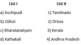
     

Detailed Solution for APSET Paper 2 Mock Test - 10 (Geography) - Question 24

APSET Paper 2 Mock Test - 10 (Geography) - Question 25
Consider the following statements about the Lateritic soils:

1) It is of little use in crop production

2) It is highly retentive of moisture

3) It cover an area of about 2.48 lakh sq. km.

4) It is rich in potash and lime.

Which of the following options are correct?

Detailed Solution for APSET Paper 2 Mock Test - 10 (Geography) - Question 25

The Lateritic soils are widely spread over an area of 2.48 lakh sq. km. and is found mainly on the summits of Western Ghats , eastern Ghats, the Rajmahal Hills, Vindhyas, Satpura and Malwa plateau. These soils are of little use in agriculture because of low fertility caused by intensive leaching and lack of lime, silica, potash. But these soils provide materials for building purposes as they are considered as the end product of weathering and are durable.

APSET Paper 2 Mock Test - 10 (Geography) - Question 26

During the cold weather season, in the northern plains, there will be an inflow of cyclonic disturbances from the ______ directions.

Detailed Solution for APSET Paper 2 Mock Test - 10 (Geography) - Question 26

The Correct Answer is West and Northwest.

Key Points

  • Western Disturbances
    • Western Disturbances begin is a low-pressure system that originates in the Mid-latitude region near the Atlantic Ocean and Europe.
  • Western Disturbances develop in the mid-latitude region (north of the Tropic of Cancer), not in the tropical region, therefore they are called mid-latitude storms or extra-tropical storms
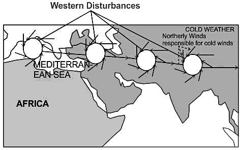
  • A characteristic feature of the cold weather season over the northern plains is the inflow of cyclonic disturbances from the west and the northwest.
  • These low-pressure systems, originate over the Mediterranean Sea and western Asia and move into India, along with the westerly flow.
  • They cause much-needed winter rains over the plains and snowfall in the mountains.

Additional Information

  • The low pressure typically forms over the Mediterranean Sea and travels over Iran, Iraq, Afghanistan, and Pakistan before entering India loaded with moisture.
  • This disturbance is usually associated with a cloudy sky, higher night temperatures, and unusual rain.
  • These moisture-laden western disturbances eventually come up against the Himalayas and get blocked, as a consequence, the moisture gets trapped and precipitation is shared in the form of snow and rain over Northwest India and sometimes, other parts of North India.
  • The rainfall during the winter season helps agriculture, particularly for rabi crops including wheat, which is one of the most important Indian crops.
APSET Paper 2 Mock Test - 10 (Geography) - Question 27

Which of the following is NOT a direct consequence of global warming?

Detailed Solution for APSET Paper 2 Mock Test - 10 (Geography) - Question 27

Option 4) Expansion of deserts and decrease in overall rainfall.

Global warming is a major threat to the planet, and it is already having a number of serious consequences. These consequences include rising sea levels, increased frequency and intensity of extreme weather events, and disruption of water supplies from melting glaciers. However, not all of the options listed in the query are direct consequences of global warming.

Key Points

Expansion of deserts and decrease in overall rainfall

  • Expansion of deserts and decrease in overall rainfall is not a direct consequence of global warming.
  • While climate change can affect precipitation patterns, it is not clear whether it will lead to an expansion of deserts and a decrease in overall rainfall.
  • Global warming is a serious threat to the planet, and it is important to take action to reduce greenhouse gas emissions and mitigate its effects.

Additional Information

Rising sea levels

Rising sea levels is a direct consequence of global warming. As the Earth's atmosphere warms, the oceans expand and glaciers melt, causing sea levels to rise. Rising sea levels can lead to flooding, erosion, and other coastal hazards.

Increased frequency and intensity of extreme weather events

Increased frequency and intensity of extreme weather events is a direct consequence of global warming. As the Earth's atmosphere warms, it can hold more moisture, which can lead to more frequent and intense storms, floods, and droughts.

Disruption of water supplies from melting glaciers

Disruption of water supplies from melting glaciers is a direct consequence of global warming. As glaciers melt, they can disrupt water supplies for communities and ecosystems downstream.

APSET Paper 2 Mock Test - 10 (Geography) - Question 28

According to the passage, the primary driver of global warming is:

Detailed Solution for APSET Paper 2 Mock Test - 10 (Geography) - Question 28

Option 3) Human activities leading to greenhouse gas emissions

The primary driver of global warming is human activities leading to greenhouse gas emissions.

Key Points

Human activities leading to greenhouse gas emissions:

  • Human activities leading to greenhouse gas emissions are the primary driver of global warming.
  • Greenhouse gases trap heat in the atmosphere, causing the Earth's temperature to rise.
  • The main greenhouse gases released by human activities are carbon dioxide, methane, and nitrous oxide.

Additional Information

Increased volcanic activity: Increased volcanic activity is not the primary driver of global warming. Volcanic eruptions can release greenhouse gases into the atmosphere, but the amount of greenhouse gases released by volcanoes is relatively small compared to the amount of greenhouse gases released by human activities.

Natural fluctuations in solar radiation: Natural fluctuations in solar radiation can affect the Earth's climate, but they are not the primary driver of global warming. The amount of solar radiation reaching the Earth's surface has been relatively stable over the past century, while the Earth's temperature has continued to rise.

A sudden shift in Earth's magnetic field: A sudden shift in Earth's magnetic field is not the primary driver of global warming. The Earth's magnetic field protects the Earth from harmful solar radiation, but it does not affect the Earth's temperature.

Important Points

  • The burning of fossil fuels is the main human activity that leads to greenhouse gas emissions.
  • Fossil fuels release carbon dioxide into the atmosphere when they are burned.
  • Other human activities that lead to greenhouse gas emissions include deforestation, agriculture, and industrial processes.
APSET Paper 2 Mock Test - 10 (Geography) - Question 29

Which is not an effect of ocean current on the socio-economic and climatic condition of the coastal region?

Detailed Solution for APSET Paper 2 Mock Test - 10 (Geography) - Question 29

Ocean currents

  • Ocean currents are like rivers flowing in oceans.
  • They represent a regular volume of water in a definite path and direction.
  • Ocean currents are influenced by two types of forces namely :
    • Primary forces that initiate the movement of water;
    • Secondary forces that influence the currents to flow

Important Point

​​The primary forces that influence the currents are

  • Heating by solar energy
  • Wind
  • Gravity

Coriolis force

  • The Coriolis force intervenes and causes the water to move to the right in the northern hemisphere and to the left in the southern hemisphere.
  • These large accumulations of water and the flow around them are called Gyres.
  • These produce large circular currents in all the ocean basins.

Key Points

Effects of Ocean Currents

  • Ocean currents have a number of direct and indirect influences on human activities.
  • West coasts of the continents in tropical and subtropical latitudes (except close to the equator) are bordered by cool waters.
    • Their average temperatures are relatively low with narrow diurnal and annual ranges.
    • There is fog, but generally, the areas are arid.
  • West coasts of the continents in the middle and higher latitudes are bordered by warm waters which cause a distinct marine climate.
    • They are characterized by cool summers and relatively mild winters with a narrow annual range of temperatures.
  • Warm currents flow parallel to the east coasts of the continents in tropical and subtropical latitudes.
    • This results in warm and rainy climates.
    • These areas lie in the western margins of the subtropical anti-cyclones.
  • The mixing of warm and cold currents helps to replenish the oxygen and favor the growth of planktons, the primary food for the fish population.
    • The best fishing grounds of the world exist mainly in these mixing zones.

Hence, it is can be concluded from the above discussion that the deflection of wind due to the Coriolis force is not an effect of ocean current.

APSET Paper 2 Mock Test - 10 (Geography) - Question 30
Which of the following statements about Indian Geography is not correct?
Detailed Solution for APSET Paper 2 Mock Test - 10 (Geography) - Question 30

OHK Spate was a British Geographer who has contributed in the regional geography of India. He is best known for his book titled “India and Pakistan: A General and Regional Geography” published in 1954.

View more questions
60 tests
Information about APSET Paper 2 Mock Test - 10 (Geography) Page
In this test you can find the Exam questions for APSET Paper 2 Mock Test - 10 (Geography) solved & explained in the simplest way possible. Besides giving Questions and answers for APSET Paper 2 Mock Test - 10 (Geography), EduRev gives you an ample number of Online tests for practice

Top Courses for AP TET

Download as PDF

Top Courses for AP TET