AP TET Exam  >  AP TET Tests  >  APSET Mock Test Series 2025  >  APSET Paper 2 Mock Test - 7 (Geography) - AP TET MCQ

APSET Paper 2 Mock Test - 7 (Geography) - AP TET MCQ


Test Description

30 Questions MCQ Test APSET Mock Test Series 2025 - APSET Paper 2 Mock Test - 7 (Geography)

APSET Paper 2 Mock Test - 7 (Geography) for AP TET 2024 is part of APSET Mock Test Series 2025 preparation. The APSET Paper 2 Mock Test - 7 (Geography) questions and answers have been prepared according to the AP TET exam syllabus.The APSET Paper 2 Mock Test - 7 (Geography) MCQs are made for AP TET 2024 Exam. Find important definitions, questions, notes, meanings, examples, exercises, MCQs and online tests for APSET Paper 2 Mock Test - 7 (Geography) below.
Solutions of APSET Paper 2 Mock Test - 7 (Geography) questions in English are available as part of our APSET Mock Test Series 2025 for AP TET & APSET Paper 2 Mock Test - 7 (Geography) solutions in Hindi for APSET Mock Test Series 2025 course. Download more important topics, notes, lectures and mock test series for AP TET Exam by signing up for free. Attempt APSET Paper 2 Mock Test - 7 (Geography) | 100 questions in 120 minutes | Mock test for AP TET preparation | Free important questions MCQ to study APSET Mock Test Series 2025 for AP TET Exam | Download free PDF with solutions
APSET Paper 2 Mock Test - 7 (Geography) - Question 1

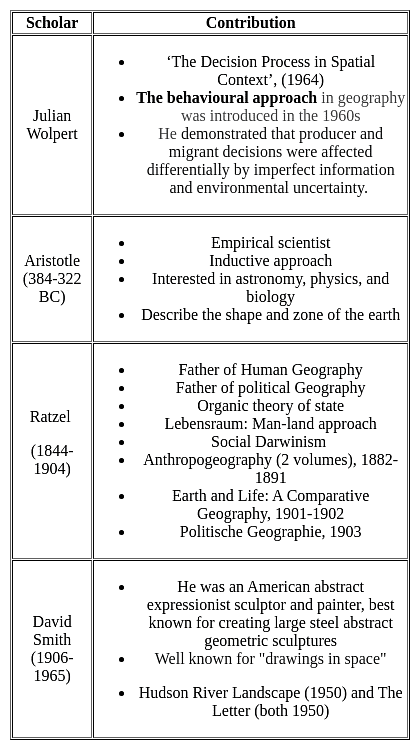
Which one of the following pairs is NOT matched correctly?

Detailed Solution for APSET Paper 2 Mock Test - 7 (Geography) - Question 1

David Smith : Marxist perspective is NOT matched correctly
Important Point

APSET Paper 2 Mock Test - 7 (Geography) - Question 2

Who conceptualized electromagnetic radiation as an electromagnetic wave that travels through space at the speed of light?

Detailed Solution for APSET Paper 2 Mock Test - 7 (Geography) - Question 2

James Clerk Maxwell was the one who conceptualized the wave nature of the EMR and stated that Electromagnetic energy propagates in harmonic sinusoidal wave motion, consisting of inseparable revolving electric and magnetic fields that are always perpendicular to one another and to the direction of propagation. All EM radiation travel with the same speed in a particular medium and equal to the velocity of light in a vacuum. Hence it can be stated as c=f*(lambda). Where, c= speed of light, f =frequency, lambda= wavelength.

1 Crore+ students have signed up on EduRev. Have you? Download the App
APSET Paper 2 Mock Test - 7 (Geography) - Question 3

Which is the lowest layer of the atmosphere?

Detailed Solution for APSET Paper 2 Mock Test - 7 (Geography) - Question 3

The correct answer is Troposphere.

Key Points

  • Troposphere
    • The troposphere is the lowest layer of the Earth's atmosphere.
    • The air is very well mixed and the temperature decreases with altitude.
    • The air in the troposphere is heated from the ground up.
    • The surface of the Earth absorbs energy and heats up faster than the air does.

Additional Information

  • The different layers of the atmosphere are listed below:
    • Exosphere
      • This is the upper limit of our atmosphere.
      • It extends from the top of the thermosphere up to 10,000 km (6,200 mi).
    • Thermosphere
      • The thermosphere starts just above the mesosphere and extends to 600 km (372 miles) high.
      • Aurora and satellites occur in this layer.
    • Mesosphere
      • The mesosphere starts just above the stratosphere and extends to 85 km (53 miles) high.
      • Meteors burn up in this layer.
    • Stratosphere
      • The stratosphere starts just above the troposphere and extends to 50 km (31 miles) high.
      • The ozone layer, which absorbs and scatters the solar ultraviolet radiation, is in this layer.
    • Ionosphere
      • The ionosphere is an abundant layer of electrons and ionized atoms and molecules that stretches from about 48 km.
      • The ionosphere is a critical link in the chain of Sun-Earth interactions.
      • This region is what makes radio communications possible.

APSET Paper 2 Mock Test - 7 (Geography) - Question 4

Given below are the two statements, one labelled as Assertion (A) and the other labelled as Reason (R). Select your answer from the code given below :

Assertion (A) : According, to Lee’s migration model, metropolitan areas are centers for immigration.

Reason (R) : The metropolitan areas have pull factors.

Code :

Detailed Solution for APSET Paper 2 Mock Test - 7 (Geography) - Question 4

The metropolitan areas have forces which attract people who want to migrate. These forces include better lifestyle, employment opportunities, educational facilities, etc. These forces were termed as pull factors by Lee. Thus, metropolitan areas have pull factors and have high rates of immigration. Thus, (A) and (R) are true and (R) is the correct explanation of (A).

APSET Paper 2 Mock Test - 7 (Geography) - Question 5

Census data released on july 15,2011 reflects that 13.48 percent urban population lives in

Detailed Solution for APSET Paper 2 Mock Test - 7 (Geography) - Question 5

As per census 2011, Maharashtra has 13.48% of urban population. About 70% of population of India lives in rural areas. Goa & Mizoram are 1st in terms of being urban whereas Himachal Pradesh has 90% rural population, the most in India.

APSET Paper 2 Mock Test - 7 (Geography) - Question 6
Given below are two statements- one is labelled as Assertion (A) and the other is labelled as Reason (R):

Assertion(A)- Exogenous processes are responsible for gradation.

Reason(R)- Weathering and erosion is often described as the essential phase in the denudation process of landscapes.

Choose the correct option:

Detailed Solution for APSET Paper 2 Mock Test - 7 (Geography) - Question 6

Gradation is nothing but the erosion of a rugged landscape into a level land. The gradation is achieved because of Degradation and Aggradation. Weathering and erosion have the capability to convert hard massive rocks into finer material. Hence for this, Weathering is often known as the first essential phase in the denudation or gradation of landscapes as it prepares the rock materials for transportation, depositional processes as well as provides for the degradation of landscapes.

APSET Paper 2 Mock Test - 7 (Geography) - Question 7

Consider the following statements:

1. India has become the largest producer of sugar.

2. Karnataka is the largest producer of coconut in India.

3. India has also become the second largest exporter of sugar after Brazil.

4. The highest amount of millet is produced by Rajasthan.

How many of the statements given above are correct?

Detailed Solution for APSET Paper 2 Mock Test - 7 (Geography) - Question 7

The correct answer is Only three

Key Points

Sugar Production:

  • India overtakes other countries to become the world's top producer and user. Hence, statement 1 is correct.
  • With a record-breaking 35.9 million tonnes of sugar produced between October and September.
  • India overtook Brazil as the world's top producer.
  • Although it is the second largest exporter of sugar after Brazil. Hence, statement 3 is correct.

Coconut Production:

  • The world's largest producer of coconuts is India.
  • The nation's traditional coconut-based operations include:
    • the processing of copra
    • the extraction of coconut oil
    • the production of coir.
  • Karnataka is the major producer of coconut in India. Hence, statement 2 is correct.
  • Followed by Tamil Nadu, Kerala and Andhra Pradesh account for the majority of India's coconut production.
  • Gujarat, West Bengal, and Orissa are some of the other states in the nation that grow coconuts.

Millet Production:

  • The world's largest producer of millet is India.
  • Currently, the production of millet in India is accounted for by ten states collectively almost 100%.
  • Over 81% of all millet products are produced in three states: Rajasthan, UP, and Haryana.
  • In India, half of the country's entire millet production comes from Rajasthan. Hence, statement 4 is correct.
APSET Paper 2 Mock Test - 7 (Geography) - Question 8

Which of the following States is least developed in rail routes?

Detailed Solution for APSET Paper 2 Mock Test - 7 (Geography) - Question 8

Manipur States is least developed in rail routes. Manipur has one railway station, Jiribam.

APSET Paper 2 Mock Test - 7 (Geography) - Question 9
The sector benefited least by the process of globalization is _____
Detailed Solution for APSET Paper 2 Mock Test - 7 (Geography) - Question 9

The sector benefited least by the process of globalization is agricultural sector.

Key Points

  • Globalization refers to increases in the movement of finance, inputs, output, information, and science across vast geographic areas.
  • Recent globalization has been characterized by a decline in the costs of cross-border trade in farm and other products.
  • It has been driven primarily by the information and communication technology revolution and—in the case of farm products—by reductions in governmental distortions to agricultural production, consumption and trade.
  • Both have boosted economic growth and reduced poverty globally, especially in Asia. 
  • Globalization has allowed agricultural production to grow much faster than in the past.
  • A few decades ago fast growth was somewhat over 3 percent per year. Now it is 4 to 6 percent.
  • However, these higher rates of growth involve a substantial change in its composition.
  • The bulk of growth initially came from basic food staples when the scope for export markets is limited, whereas there is now a swing towards much higher value commodities.
  • Explosive growth in income of high-income countries means that large aggregates of production can now occur in what were previously small niche markets. High quality coffee and tea are examples.
  • The market for horticulture exports has also grown immensely and can continue to grow.

Hence,the agricultural sector is least benefitted by globalizatin though it experiencing changes recently.

APSET Paper 2 Mock Test - 7 (Geography) - Question 10
Near 400 N latitude, the Gulf stream is called as
Detailed Solution for APSET Paper 2 Mock Test - 7 (Geography) - Question 10

The North equatorial current gets deflected towards north in the higher latitudes and is called Gulf Stream in the area. It increases rainfall along the east coast of North America. As it nears the 400 N latitude, it drifts east and is called as North Atlantic Drift.

Thus, the correct answer is D.

APSET Paper 2 Mock Test - 7 (Geography) - Question 11
Given below are two statements- one is labelled as Assertion (A) and the other is labelled as Reason (R):

Assertion(A)- Fogs, urban smog’s, frost generally affect the economy.

Reason(R)- Inversion of temperature is known as the negative lapse rate.

Choose the correct options.

Detailed Solution for APSET Paper 2 Mock Test - 7 (Geography) - Question 11

We all know, temperature decreases with increasing altitudes in the troposphere at an altitude of 6.5 degree Celsius per 1000 meters but this trend sometimes gets reversed under special circumstances and hence is known as negative lapse rate. Thus, warm air layer lies over cold air layer. However, because of this inversion of temperature, several significant changes can be observed. The significance of this reversal is that there are al lot of climatic effects that affect the surrounding environment as well as the economy.

APSET Paper 2 Mock Test - 7 (Geography) - Question 12

Consider the following factors with respect to the temperature of a place:

1. Distance from the sea.

2. Latitude and altitude.

3. Air mass and ocean currents.

Which of the above affect the temperature of a place?
Detailed Solution for APSET Paper 2 Mock Test - 7 (Geography) - Question 12

The temperature of air at any place is influenced by the following factors:

The latitude:

  • The temperature of a place depends on the insolation received.
  • The insolation varies according to the latitude hence the temperature also varies accordingly.


The altitude:

  • The atmosphere is indirectly heated by terrestrial radiation from below. Therefore, the places near the sea-level record higher temperature than the places situated at higher elevations.
  • Temperature generally decreases with increasing height.
  • The rate of decrease of temperature with height is termed as the normal lapse rate. It is 6.5°C per 1,000 m.


Distance from the sea:

  • The location of a place with respect to the sea also determines the temperature of that place.
  • Compared to land, the sea gets heated slowly and loses heat slowly. Land heats up and cools down quickly. Therefore, the variation in temperature over the sea is less compared to land.
  • The places situated near the sea come under the moderating influence of the sea and land breezes which moderate the temperature.


Air-mass and Ocean currents:

  • The places, which come under the influence of warm air masses experience higher temperature and the places that come under the influence of cold air masses experience low temperature.
  • Similarly, the places located on the coast where the warm ocean currents flow record higher temperature than the places located on the coast where the cold currents flow.
APSET Paper 2 Mock Test - 7 (Geography) - Question 13

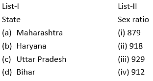
Match the List-I with List-II

Choose the correct option:

Detailed Solution for APSET Paper 2 Mock Test - 7 (Geography) - Question 13

The sex ratio of India, as per the census of India of 2011 is 940 females per thousand males.

  • Haryana is the state with lowest sex ratio of 879.
  • Maharashtra ranks 22nd in the whole country with sex ratio of 929
  • Bihar ranks 25th and has sex ratio of 918
  • Uttar Pradesh has sex ratio of 912 and ranks 26th in India.

Thus, the correct answer is A.

APSET Paper 2 Mock Test - 7 (Geography) - Question 14

Consider the following statements-

1. These winds blow from the subtropical high-pressure belts towards the sub-polar low-pressure belts.

2. They are stronger in the southern hemisphere. 

3. These winds are best developed between 40° and 65°S latitudes.

Statements given-above are about which planetary wind?

Detailed Solution for APSET Paper 2 Mock Test - 7 (Geography) - Question 14

The correct answer is Westerlies.

Key Points

  •  Westerlies:
    • The westerlies are the winds blowing from the subtropical high-pressure belts towards the subpolar low-pressure belts.
    • They blow from south­west to north-east in the northern hemisphere and north-west to south-east in the southern hemisphere.
    • The westerlies of the southern hemisphere are stronger and persistent due to the vast expanse of water, while those of the northern hemisphere are irregular because of uneven relief of vast land-masses.
    • The westerlies are best developed between 40° and 65°S latitudes.

Additional Information

  • Primary Winds or Prevailing Winds or Permanent Winds or Planetary Winds
    • These are the planetary winds which blow extensively over continents and oceans.
    • The two most well-understood and significant winds for climate and human activities are trade winds and westerly winds.
  • Trade Winds:
    • The trade winds are those blowing from the sub-tropical high-pressure areas towards the equatorial low-pressure belt
    • Therefore, these are confined to a region between 30°N and 30°S throughout the earth’s surface.
    • They flow as the north-eastern trades in the northern hemisphere and the south-eastern trades in the southern hemisphere.
    • Trade winds are descending and stable in areas of their origin (sub-tropical high-pressure belt), and as they reach the equator, they become humid and warmer after picking up moisture on their way.
    • The trade winds from two hemispheres meet at the equator, and due to convergence they rise and cause heavy rainfall.
  • Polar easterlies:
    • The Polar easterlies are dry, cold prevailing winds blowing from north-east to south-west direction in Northern Hemisphere and south-east to the north-west in Southern Hemisphere.
    • They blow from the polar high-pressure areas of the sub-polar lows
APSET Paper 2 Mock Test - 7 (Geography) - Question 15
Biomagnification means an increase in the
Detailed Solution for APSET Paper 2 Mock Test - 7 (Geography) - Question 15

Biomagnification means an increase in the concentration of pollutants in living organisms.

  • Biomagnification is a process by which contaminant concentrations increase in the tissue of higher species of the food chain.
  • Biomagnification, also known as bio amplification or biological magnification, is any concentration of a toxin, such as pesticides, in the tissues of tolerant organisms at successively higher levels in a food chain.
  • This increase can occur as a result of:
    • Persistence – where the substance cannot be broken down by environmental processes
    • Food chain energetics – where the substance's concentration increases progressively as it moves up a food chain
    • Low or non-existent rate of internal degradation or excretion of the substance – mainly due to water-insolubility
  • Biological magnification often refers to the process whereby certain substances such as pesticides or heavy metals work their way into lakes, rivers, and the ocean, and then move up the food chain in progressively greater concentrations as they are incorporated into the diet of aquatic organisms such as zooplankton, which in turn are eaten perhaps by fish, which then may be eaten by bigger fish, large birds, animals, or humans.
  • The substances become increasingly concentrated in tissues or internal organs as they move up the chain.
  • Bioaccumulants are substances that increase in concentration in living organisms as they take in contaminated air, water, or food because the substances are very slowly metabolized or excreted.

Thus, option 1 is the correct answer.

APSET Paper 2 Mock Test - 7 (Geography) - Question 16
Who among the following has proposed model of development based on principle linear development?
Detailed Solution for APSET Paper 2 Mock Test - 7 (Geography) - Question 16

Correct Answer: ​Rostow.

Key Points

  • The most popular linear stage models are Rostow’s Stages of Growth Model and the Harrod-Domar Growth Model.
  • One of the first growth theories was that proposed by American economic historian Walt Rostow in the early 1960s. Rostow’s Stages of Growth Model.
  • This approach was formulated by American Economist Walt Whitman Rostow (1916-2003). He argued in his model that the transition into development occurs in a series of stages. Each stage can only be reached through the completion of the previous stage. He asserts that all developed countries have gone through these stages and developing countries are in one of these stages. These stages are as follows:
  • Traditional society is dominated by agriculture and barter exchange, and where science and technology are not understood or exploited.
  • Pre-take-off stage, with the development of education and an understating of science, the application of science to technology and transport, and the emergence of entrepreneurs and a simple banking system, and hence rising savings.
  • Take-off, with positive growth rates in particular sectors and where organized systems of production and reward replace traditional methods and norms.
  • The drive to maturity in this stage takes place after a long period of time. The population involved in agriculture declines while industry becomes more diverse. The overall income per capita increases. The rate of savings and investments is such that it can automatically sustain economic growth.
  • Stage of Mass Consumption at this stage a country’s demand shifts from food, clothing, and other basic necessities to demand luxuries. To satisfy these needs new industries involve their selves in mass production to match consumption.
  • Rostow’s work, like many other accounts of growth, points to the significance of the accumulation of savings to achieve take-off – in this case as a necessary condition for the movement from traditional to developed societies.

Additional Information

  • Rostow's Stages of Growth model is one of the most influential development theories of the 20th century. It was, however, also grounded in the historical and political context in which he wrote. "Stages of Economic Growth" was published in 1960, at the height of the Cold War, and with the subtitle "A Non-Communist Manifesto," it was overtly political. Rostow was fiercely anti-communist and right-wing; he modeled his theory after western capitalist countries, which had industrialized and urbanized. As a staff member in President John F. Kennedy's administration, Rostow promoted his development model as part of U.S. foreign policy. Rostow's model illustrates a desire not only to assist lower-income countries in the development process but also to assert the United States' influence over that of communist Russia.
  • The theories of Rostow, Harrod Domar, and others consider savings to be a sufficient condition for growth and development. In other words, if an economy saves, it will grow, and if it grows, it must develop. Aggregate savings are largely determined by national income, so if income is low, savings will not be accumulated. According to Rostow’s theory, saving between 15% and 20% of income (a savings ratio of 0.15 – 0.2) would be enough to provide the basis for growth. If this level of saving is maintained, growth would also be sustained.

Major criticisms of this approach include:

  • Although saving is regarded as highly significant, modern growth theory takes into account a broad set of growth factors.
  • Other criticisms of the stage theory point to general weakness in terms of the unrealistic assumptions of these models, such as perfect knowledge, stable exchange rates, and constant terms of trade.
  • Most analyses were based on the reconstruction of Europe after World War II, but most developing countries do not have Europe’s institutions, attitudes, financial markets, levels of education, and desire to succeed as found in Europe.
  • Modern theory tends to see savings as a necessary but not sufficient condition for growth.
APSET Paper 2 Mock Test - 7 (Geography) - Question 17

A rise in sea level near shore due to strong winds is called

Detailed Solution for APSET Paper 2 Mock Test - 7 (Geography) - Question 17

A storm surge is a rise in sea level that occurs during tropical cyclones, intense storms also known as typhoons or hurricanes. The storms produce strong winds that push the water into shore, which can lead to flooding.

APSET Paper 2 Mock Test - 7 (Geography) - Question 18
Consider the following statements about rectangular drainage pattern:

a. Generally results from the presence of joints and fractures

b. The arrangement of the channels is such that the principal tributary streams are parallel and very long.

c. Common in areas with parallel fractures or faults.

d. Characterised by right-angle bends.

Which of the above statements are correct?

Detailed Solution for APSET Paper 2 Mock Test - 7 (Geography) - Question 18

Rectangular streams are channel systems marked by right-angle bends and generally results from the presence of joints and fractures in massive rocks or foliation in metamorphic rocks. Such structures with their cross-cutting patterns have guided the directions of valleys.

The other two options depict a trellis pattern.

APSET Paper 2 Mock Test - 7 (Geography) - Question 19

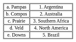
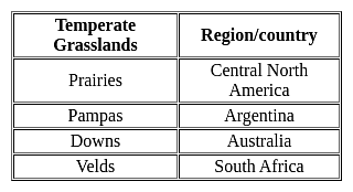
Match the following -

Detailed Solution for APSET Paper 2 Mock Test - 7 (Geography) - Question 19

Important PointsTemperate Grasslands:

  • Temperatures vary much more in temperate grasslands than they do in savannas.
  • Savannas are in warm climates with average annual temperatures that only vary between 21 and 26 degrees Celsius (70 and 78 degrees Fahrenheit).
  • They typically have only two seasons, a wet and a dry season.
  • Temperate grasslands have hot summers where temperature can exceed 38 degrees Celsius (100 degrees Fahrenheit) and cold winters that can drop below negative 40 degrees Celsius (negative 40 degrees Fahrenheit).

Key Points


Hence, the correct matching is a - 1, b - 5, c - 4, d - 3, e - 2

APSET Paper 2 Mock Test - 7 (Geography) - Question 20
According to Hirschman, what is the main prerequisite for economic growth?
Detailed Solution for APSET Paper 2 Mock Test - 7 (Geography) - Question 20
Answer: Option 1) Creating Unbalances.
Albert O. Hirschman, a prominent development economist, introduced the concept of unbalanced growth as a strategy for economic development in developing countries. His theory challenges the notion of balanced growth, which advocates for simultaneous investment across all sectors of the economy.
Key Points
  • According to Hirschman, the main prerequisite for economic growth is the creation of imbalances. He argues that balanced growth is unattainable and undesirable for developing countries due to limited resources, capital, skilled labor, and essential raw materials. Instead, he proposes that countries should focus on strategic investments in selected sectors to generate growth through backward and forward linkages.
  • Backward linkages refer to the stimulation of industries that supply raw materials and inputs to the selected sector. For example, investing in a steel plant would increase demand for steel scrap and coal, leading to increased production in these industries.
  • Forward linkages, on the other hand, refer to the growth of industries that utilize the output of the selected sector. Continuing with the steel plant example, the expansion of the steel industry would encourage the growth of industries that use steel as a primary input, such as machine tool manufacturing.
  • By creating imbalances through targeted investments, Hirschman argues that developing countries can generate a chain reaction of growth across different sectors of the economy. This process helps to overcome the resource constraints and structural bottlenecks that often hinder development.
Additional Information
  • Hirschman's theory of unbalanced growth has been influential in development economics, and has been applied to various contexts, including industrialization, infrastructure development, and agricultural modernization.
  • Critics of Hirschman's theory argue that it may lead to excessive concentration of investment in certain sectors, neglecting other important areas of the economy.
  • The concept of unbalanced growth has been further developed by other economists, such as Paul Rosenstein-Rodan and Ragnar Nurkse, who emphasized the importance of balanced growth in the long run.
APSET Paper 2 Mock Test - 7 (Geography) - Question 21
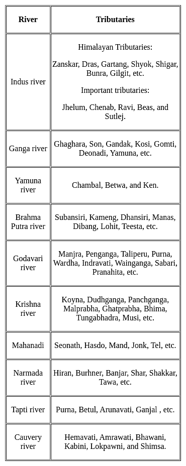
The Koyna, Tungabhadra and Bhima rivers are the major tributaries of the river ___________.
Detailed Solution for APSET Paper 2 Mock Test - 7 (Geography) - Question 21

The correct answer is Krishna.

Key Points

APSET Paper 2 Mock Test - 7 (Geography) - Question 22

The average air pressure at the sea level is ……………… millibars

Detailed Solution for APSET Paper 2 Mock Test - 7 (Geography) - Question 22

Standard sea-level pressure, by definition, equals 760 mm (29.92 inches) of mercury, 14.70 pounds per square inch, 1,013.25 × 103 dynes per square centimetre, 1,013.25 millibars, one standard atmosphere, or 101.325 kilopascals.

APSET Paper 2 Mock Test - 7 (Geography) - Question 23
Which of the following is a cause of Global warming?
Detailed Solution for APSET Paper 2 Mock Test - 7 (Geography) - Question 23

Global warming refers to increase in average temperature of the earth. Melting of glaciers and lack of snowfall are effects of global warming. Deforestation on the other hand leads to increase in carbon dioxide and ultimately to global warming.

Thus, the correct answer is D.

APSET Paper 2 Mock Test - 7 (Geography) - Question 24
The principle of GPS positioning is:
Detailed Solution for APSET Paper 2 Mock Test - 7 (Geography) - Question 24

Explanation:

GPS:

  • The Global Positioning System (GPS) is a satellite-based navigation and surveying system for the determination of precise position and time, using radio signals from the satellites, in real-time or in post-processing mode.
  • GPS is being used all over the world for numerous navigational and positioning applications, including navigation on land, in the air and at sea, determining the precise coordinates of important geographical features as an essential input to mapping and Geographical Information systems (GIS), along with its use for precise cadastral surveys, vehicle guidance in cities and on highways using GPS-GIS integrated systems, earthquake and landslide monitoring, etc.

GPS Positioning:

  • GPS is a constellation of 24 or more satellites flying 20,350 km above the surface of the earth. Each one circle the planet twice a day in one of six orbits to provide continuous, worldwide coverage.
  • The absolute coordinates of the antenna position (centered over the survey station) are determined using a single GPS receiver, by a method similar to the resection method used in plane tabling.

How GPS Works:

  1. GPS satellites broadcast radio signals providing their locations, status, and precise time (t1) from onboard atomic clocks.
  2. The GPS radio signals travel through space at the speed of light (c), more than 299,792 km/second.
  3. GPS device receives the radio signals, noting their exact time of arrival (t2), and uses these to calculate its distance from each satellite in view.
  4. Once a GPS device knows its distance from at least four satellites, it can use geometry to determine its location on Earth in three dimensions
APSET Paper 2 Mock Test - 7 (Geography) - Question 25

Determine the functions of GIS from the options given below.

(A) Data Capture

(B) Data Storage and Manipulation

(C) Data Analysis

(D) Data presentation

Choose the correct answer from the options given below:
Detailed Solution for APSET Paper 2 Mock Test - 7 (Geography) - Question 25

A geographic information system (GIS) is a system that creates, manages, analyzes, and maps all types of data. GIS connects data to a map, integrating location data (where things are) with all types of descriptive information (what things are like there). This provides a foundation for mapping and analysis that is used in science and almost every industry. GIS helps users understand patterns, relationships, and geographic context. The benefits include improved communication and efficiency as well as better management and decision-making.

Key Points

Functions of GIS include data entry, data display, data management, information retrieval, and analysis.

  • Data Capture:
    • The input of data into a GIS can be achieved through many different methods of gathering.
    • For example, aerial photography, scanning, digitizing, and GNSS are just a few of the ways a GIS user could obtain data.
    • Digitization: A conversion process that converts paper maps into numerical digits that can be stored in the computer.
    • Digitizing simplifies map data into sets of points, lines, or cells that can be stored in the GIS computer.
    • In this stage, digitization is carried out.
    • There are two basic methods of digitization: Manual digitizing & scanning.
  • Data storage
    • ​It is based on a Generic Data Model that is used to convert map data into a digital form.
    • The two most common types of data models are Raster and Vector.
    • Both types are used to simplify the data shown on a map into a more basic form that can be easily and efficiently stored in the computer.
  • Data Manipulation:
    • The digital geographical data can be edited, this allows for many attributes to be added, edited, or deleted to the specification of the project.
    • Once data are stored in a GIS, many manipulation options are available to users.
    • These functions are often available in the form of “Toolkits.”
    • A toolkit is a set of generic functions that a GIS user can employ to manipulate and analyze geographical data.
  • Analysis:
    • The heart of GIS is the analytical capabilities of the system.
    • What distinguishes the GIS system from other information systems is its spatial analysis functions.
    • Although the data input is, in general, the most time-consuming part, it is for data analysis that GIS is used.
    • The analysis functions use the spatial and non-spatial attributes in the database to answer questions about the real world.

Hence, all the mentioned options are considered as the function of GIS.

APSET Paper 2 Mock Test - 7 (Geography) - Question 26
Who pioneered the idea of scientific study of society?
Detailed Solution for APSET Paper 2 Mock Test - 7 (Geography) - Question 26

Auguste Comte proposed the idea of the scientific study of society.

Key Points

  • Sociology is the scientific study of society, encompassing social interaction, cultural practices, and social connection patterns.
  • When he advocated a synthetic science integrating all knowledge about human behavior in the 1830s, the Frenchman Auguste Compte used the term "sociology" for the first time.
  • Sociology is one of the social sciences according to academics.
  • Plato attempted a systematic study of society
  • Adam Smith, 1723- 1790 was a Scottish social philosopher and political economist.
  • Herbert Spencer, an English sociologist, and philosopher lived from 1820 to 1903.

Thus, we know that Auguste Comte pioneered the idea of the scientific study of society.

APSET Paper 2 Mock Test - 7 (Geography) - Question 27
Given below are two statements- one is labelled as Assertion (A) and the other is labelled as Reason (R):

Assertion(A)- Green Revolution has a lot of drawbacks and several imbalances.

Reason(R)- Green revolution in India only brought about a Grain Revolution.

Choose the correct option:

Detailed Solution for APSET Paper 2 Mock Test - 7 (Geography) - Question 27

The effect of Green Revolution was primarily felt on the food grains, but the wheat benefitted the most. As a result, certain Inter crop imbalances, regional disparities, inter-personal inequalities took place. The major commercial crops such as cotton, jute, tea remained almost behind due to the green revolution. The most affected areas were Punjab, Haryana, Western Uttar Pradesh. For eliminating these problems caused by the green revolution, wider area and more crops and high yields must be considered for the green revolution. However, the Second Green Revolution was brought into life that covered all the demerits of the previous one.

APSET Paper 2 Mock Test - 7 (Geography) - Question 28
Given below are two statements- one is labelled as Assertion (A) and the other is labelled as Reason (R):

Assertion (A)- The forest resources are unevenly distributed in India.

Reason(R)- Forest cover must be kept in check regularly.

Choose the correct option:

Detailed Solution for APSET Paper 2 Mock Test - 7 (Geography) - Question 28

The forests comprise only 23.28% of our geographical area and has a much less forest cover in comparison to the other countries. This is much below the average of 30.4% for the world. Uneven distribution of forests is also quite common in the Indian states. Madhya Pradesh has the largest area of about 76 thousand sq. km. under forests. The other states have a considerable area such as Arunachal Pradesh, Chhattisgarh, Odisha, Maharashtra and Andhra Pradesh. Each of these states vary considerably in terms of forest cover.

The thoughtless and rapid exploitation of the forest resources due to increasing demand of forest products and overgrazing practices has led to a lot of damage to the ecosystem. Thus, forest conservation practices and social forestry practices must be considered.

APSET Paper 2 Mock Test - 7 (Geography) - Question 29
In the UN’s sustainable development goals are intended to be achieved by the year
Detailed Solution for APSET Paper 2 Mock Test - 7 (Geography) - Question 29

 The sustainable development goals are set of 17 goals designed to achieve the measure and problems of society and the way to sustainable deal with the same. This was set in 2015 by the United Nation general assembly and intended to be achieved by the year 2030.

Thus, the Correct answer is D .

APSET Paper 2 Mock Test - 7 (Geography) - Question 30

The Siberian Crane, an endangered migratory bird is a regular visitor of which of the following national park/bird sanctuaries:

Detailed Solution for APSET Paper 2 Mock Test - 7 (Geography) - Question 30

Keoladeo National Park in Bharatpur, Rajasthan is a famous avifauna sanctuary that plays host to thousands of birds especially during the winter season. It is also a declared World Heritage Site. The Sanctuary is one of the richest bird areas in the world. It is known for nesting of its resident birds and visiting migratory birds including water birds. The rare Siberian cranes visit the place in winter season.

View more questions
60 tests
Information about APSET Paper 2 Mock Test - 7 (Geography) Page
In this test you can find the Exam questions for APSET Paper 2 Mock Test - 7 (Geography) solved & explained in the simplest way possible. Besides giving Questions and answers for APSET Paper 2 Mock Test - 7 (Geography), EduRev gives you an ample number of Online tests for practice

Top Courses for AP TET

Download as PDF

Top Courses for AP TET