CISF Head Constable Mock Test - 9 - CISF Head Constable MCQ
30 Questions MCQ Test CISF Head Constable Mock Test Series 2024 - CISF Head Constable Mock Test - 9
A major telecom company recently hired a new Chief Financial Officer to take command of the company’s finances. This move came against the backdrop of national and global economic crises.
The CFO is charged with the responsibility of realigning the finances of the largest Strategic Business Unit which deals with network solutions to major corporate clients in the country. In wake of the overall financial slump, many of the corporate clients have been delaying the payment of their recurring dues for the monthly network and internet services utilised. The local account managers handling those clients and their respective Regional Managers had been given the authority to maintain client relations and if necessary allow the delayed payments with a view to continue a long-term relationship with the key clients. However, the new CFO after taking stock of the situation decided to put an affirmative end to this practice. He sent a mail to every regional and local account manager asking them to discontinue services to the defaulting clients. In spite of such a strong communication, most major clients delayed the payments in the next month. As a response to this, the CFO resent his earlier mail asking for comments. In the next month, the single largest client defaulted on the payment and the regional manager promptly asked the technology company to terminate services to that client. The regional manger merely informed the client that the delay in payment was responsible for the termination of services and the service would be reconstituted on payment of the dues.
The client faced severe difficulties due to discontinuation of the internet and local network services. The CEO of that company wrote a scathing email to the Chairman of the telecom company.
The CEO pointed out the sudden, mishandled and improperly communicated decision and its severe impact on his company’s business. He pointed out that they were one of the largest clients of the telecom company. The CEO also hinted that his company would want to reconsider their future engagement. The Chairman decided to maintain the relations with that important client and yet protect his company’s image. He promptly restarted the network services and yet requested the client to clear the dues within a week and to avoid major delays especially in these times of crisis. The client replied to this communication, agreeing to the specified norms. However, the Chairman decided to severely reprimand the Regional Manager and suspended him for 2 weeks. He also severely questioned the CFO for his error. At the next board of directors meeting, there was support for the Chairman’s action in spite of protests by some senior directors who defended the CFO and the Regional Manager's actions.
Q. The client’s action, and the Chairman’s response to the same, display what important aspect of decision-making shown by the Chairman?
The CFO is charged with the responsibility of realigning the finances of the largest Strategic Business Unit which deals with network solutions to major corporate clients in the country. In wake of the overall financial slump, many of the corporate clients have been delaying the payment of their recurring dues for the monthly network and internet services utilised. The local account managers handling those clients and their respective Regional Managers had been given the authority to maintain client relations and if necessary allow the delayed payments with a view to continue a long-term relationship with the key clients. However, the new CFO after taking stock of the situation decided to put an affirmative end to this practice. He sent a mail to every regional and local account manager asking them to discontinue services to the defaulting clients. In spite of such a strong communication, most major clients delayed the payments in the next month. As a response to this, the CFO resent his earlier mail asking for comments. In the next month, the single largest client defaulted on the payment and the regional manager promptly asked the technology company to terminate services to that client. The regional manger merely informed the client that the delay in payment was responsible for the termination of services and the service would be reconstituted on payment of the dues.
The client faced severe difficulties due to discontinuation of the internet and local network services. The CEO of that company wrote a scathing email to the Chairman of the telecom company.
The CEO pointed out the sudden, mishandled and improperly communicated decision and its severe impact on his company’s business. He pointed out that they were one of the largest clients of the telecom company. The CEO also hinted that his company would want to reconsider their future engagement. The Chairman decided to maintain the relations with that important client and yet protect his company’s image. He promptly restarted the network services and yet requested the client to clear the dues within a week and to avoid major delays especially in these times of crisis. The client replied to this communication, agreeing to the specified norms. However, the Chairman decided to severely reprimand the Regional Manager and suspended him for 2 weeks. He also severely questioned the CFO for his error. At the next board of directors meeting, there was support for the Chairman’s action in spite of protests by some senior directors who defended the CFO and the Regional Manager's actions.
In this following question, four words have been given, out of which three are alike in some manner and the fourth one is different. Choose out the odd one out.
| 1 Crore+ students have signed up on EduRev. Have you? Download the App |
Direction: In each question below is given a statement followed by two conclusions numbered I and II. You have to assume everything in the statement to be true, then consider the two conclusions together and decide which of them logically follows beyond a reasonable doubt from the information given in the statement.
Statements: Vegetable prices are soaring in the market.
Conclusions:
- Vegetables are becoming a rare commodity.
- People cannot eat vegetables.
Directions: Study the following information carefully and answer the given questions.
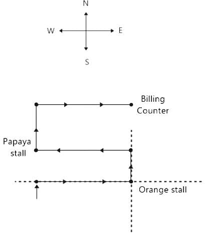
Virat goes to Supermarket store to buy fruits. He enters the market, turns to his right, walks 7m and takes oranges. Then, he turns to his left, walks 3m and takes Peach. Again, he turns to his left, which is towards west, walks 7m and takes Papayas. Again, he turns to his right and looks at guavas, which 8m away from him. He takes guavas and moves to his right, walks 7m and stops at the counter for billing.
Q. In which direction is the Papaya stall located with respect to the Orange stall?
Directions: Study the following information carefully and answer the given questions.
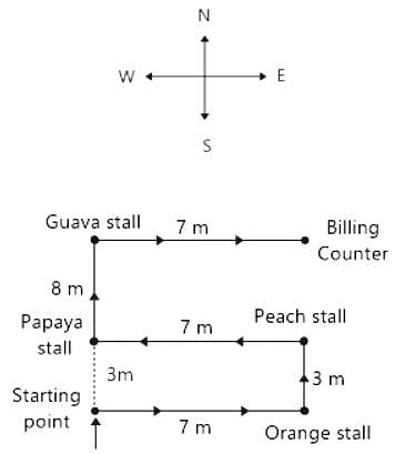
Virat goes to Supermarket store to buy fruits. He enters the market, turns to his right, walks 7m and takes oranges. Then, he turns to his left, walks 3m and takes Peach. Again, he turns to his left, which is towards west, walks 7m and takes Papayas. Again, he turns to his right and looks at guavas, which 8m away from him. He takes guavas and moves to his right, walks 7m and stops at the counter for billing.
Q. How far is the Papaya stall from the starting point?
Study the following line graph and answer the questins.
Exports from Three Companies Over the Years (in Rs. crore)
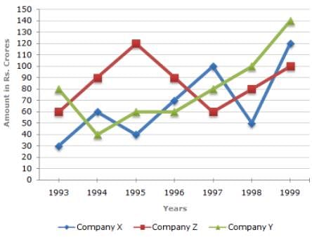
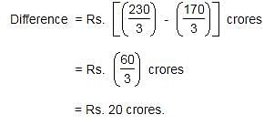
Q. What was the difference between the average exports of the three Companies in 1993 and the average exports in 1998?
The average of 10 two-digit positive integers is Z. However, one number AB is taken as BA, then the average increases to Z + 2.7. What is the value of |B - A|?
In a fort there was sufficient food for 200 soldiers for 31 days. After 27 days 120 soldiers left the fort. For how many extra days will the rest of the food last for the remaining soldiers?
The HCF and LCM of two numbers is 84 and 840 respectively. If the first number is 168, find the second one
A purse contains notes of Re. 1, Rs. 10 and Rs. 20 only. The number of notes of Re. 1 is seven times the number of notes of Rs. 10 and the number of notes of Rs. 20 is 4 times the number of notes of Rs. 10. How much money is there in the purse if there are total twelve notes of Rs. 20?
Umesh purchased 360 eggs at the rate of 78 paise each. On this, he paid Rs. 14 as octroi, Rs. 13 as transport and Rs. 5 as additional charges. He kept 7 eggs for himself. At what rate should he sell each of the remaining eggs to get a total profit of Rs. 70?
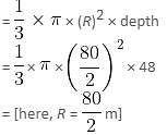
Find the approximate time taken to fill a chemical conical vessel, if the flow rate is 20 meters per minute from a cylindrical pipe whose diameter is 5 meters. Take diameter and depth of the conical vessel as 80 meters and 48 meters, respectively.
Study the following table and answer the questions based on it.
Expenditures of a Company (in Lakh Rupees) per Annum Over the given Years.
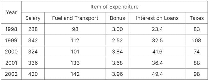
Q. The ratio between the total expenditure on Taxes for all the years and the total expenditure on Fuel and Transport for all the years respectively is approximately?
The bar chart given below shows the total exports (in = 1000 crores of a country for 7 consecutive years Y1, Y2, Y3, Y4, Y5, Y6 and Y7.
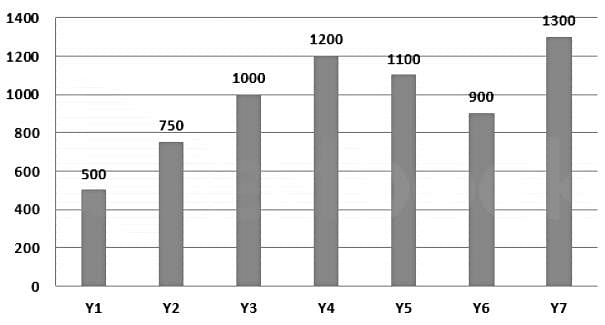
Q. What is the average exports from years Y1 to Y7?
Find out the Synonym of the following word:
INEBRIATE
Sixty miles / are / a good distance / No error.
Find the word most appropriate for Blank no. 20
The (11)____ citizen who has to get everyday jobs done by various municipal and government departments is (12)____ driven up a tree, first (13)____ them, second explaining to them what is (14)____ and lastly, getting the job done.
If this week I (15)____ some personal experience in this column, it is because I can document them. It is not to ask for any special (16)____ or voice personal (17)____ but to bring into public view the experience of hundreds, if not thousands of citizens everyday of the year and express the collective (18)____ of all of them. Because one’s usual experience is that when such complaints are (19)____ in such columns, the departments rush to (20)____
DIRECTIONS: The following question contains an idiom and its usage in a sentence, followed by four possible meanings labelled A, B, C, and D. Pick out the right meaning of the idiom in question and mark your answer accordingly.
Q.
Elbow grease.
He has reached this high stature through "elbow grease".
Directions: In the given statements, a blank has been given. This needs to be filled up using the correct combination of words from the three options mentioned, so that the resulting statement is grammatically and contextually correct.
In the ancient times, remaining alone was dangerous as _______________ animals could easily attack its solitary prey.
I. domesticated
II. wild
III. herbivorous
Direction: The sentences given in the question, when properly sequenced, form a coherent paragraph. Each sentence is labeled with a letter. Choose the most logical order of sentences from the given choices to construct a coherent paragraph.
A. As people turned to farming, they began to live in fixed settlements, which became small towns.
B. Their labors bore fruit; surplus food freed some of the population from farming.
C. In about 5000 BC, farmers moved down into the fertile river valleys of Mesopotamia, and built dykes and ditches to irrigate the arid land.
D. The cultivation of plants, such as wheat and barley, and the domestication of animals, such as sheep, goats and cattle, began in the Near East in about 8500 BC.
Directions: Read the following passage carefully and answer the questions given beside.
Remote sensing and GIS are promising tools for handling spatial and temporal data and help in integrating them for successful planning of natural resources. It is the science of measuring the earth using sensors mounted on high-flying aircrafts or satellites. These sensors collect data in the form of images and provide insights for manipulating, analysing and visualising those images. Since natural resources are not uniformly distributed and are spatially varied, it is challenging to capture the correct picture. Management of natural resources calls for scientific tools for timely and accurate dissemination of information. In natural resource management, remote sensing and GIS are mainly used in the mapping process. These techniques are useful in management of land, soil, coastal, watershed, urban and many more.
In India, the agriculture sector alone sustains the livelihood of around 50 percent of the population. Therefore, an increase in crop productivity has been a major concern. Since, the scope for increasing area under agriculture is limited, advanced crop production forecasting is required for better policymaking. Indian Space Research Agency (ISRO) and Indian Council of Agricultural Research (ICAR) successful experiment-Agricultural Resource Inventory and Survey Experiment (ARISE) used aerial colour photographs to estimate crop acreage in many states of India. Other Important uses of remote sensing include crop identification, stress detection, and crop yield modelling, drought monitoring, land degradation mapping and more. Urbanisation is important and inevitable for development, but its proper planning and management is crucial for sustenance. One of the important features of GIS is multilayered mapping. This kind of mapping helps municipal corporations, town planning boards to build cities that are better organised. The information systems with socio-economic data overlaid upon satellite data makes urban planning cost-effective and accurate.
Coastal ecosystems have high ecological significance. GIS and remote sensing data are used to study coastal ecosystems and marine living resources which include habitats like mangroves, coral reefs and more. Apart from this, suspended shoreline dynamics can be studied and climatic changes leading to cyclones and sea level rise may be of special interest too. Geospatial data is effective in the analysis and determination of factors that affect the utilisation of these resources. The technologies provide a platform through which we can generate information that can be used to make sound decisions for sustainable development of the natural resources of India.
Q. How effective are remote sensing and GIS in managing urban growth?
I. GIS and remote sensing are helpful in building cities that are better organized.
II. The system makes urban planning cost-effective and accurate.
III. They help the government disseminate people living in extremely densed areas to less populated ones.
Directions: Read the following passage carefully and answer the questions given beside.
Remote sensing and GIS are promising tools for handling spatial and temporal data and help in integrating them for successful planning of natural resources. It is the science of measuring the earth using sensors mounted on high-flying aircrafts or satellites. These sensors collect data in the form of images and provide insights for manipulating, analysing and visualising those images. Since natural resources are not uniformly distributed and are spatially varied, it is challenging to capture the correct picture. Management of natural resources calls for scientific tools for timely and accurate dissemination of information. In natural resource management, remote sensing and GIS are mainly used in the mapping process. These techniques are useful in management of land, soil, coastal, watershed, urban and many more.
In India, the agriculture sector alone sustains the livelihood of around 50 percent of the population. Therefore, an increase in crop productivity has been a major concern. Since, the scope for increasing area under agriculture is limited, advanced crop production forecasting is required for better policymaking. Indian Space Research Agency (ISRO) and Indian Council of Agricultural Research (ICAR) successful experiment-Agricultural Resource Inventory and Survey Experiment (ARISE) used aerial colour photographs to estimate crop acreage in many states of India. Other Important uses of remote sensing include crop identification, stress detection, and crop yield modelling, drought monitoring, land degradation mapping and more. Urbanisation is important and inevitable for development, but its proper planning and management is crucial for sustenance. One of the important features of GIS is multilayered mapping. This kind of mapping helps municipal corporations, town planning boards to build cities that are better organised. The information systems with socio-economic data overlaid upon satellite data makes urban planning cost-effective and accurate.
Coastal ecosystems have high ecological significance. GIS and remote sensing data are used to study coastal ecosystems and marine living resources which include habitats like mangroves, coral reefs and more. Apart from this, suspended shoreline dynamics can be studied and climatic changes leading to cyclones and sea level rise may be of special interest too. Geospatial data is effective in the analysis and determination of factors that affect the utilisation of these resources. The technologies provide a platform through which we can generate information that can be used to make sound decisions for sustainable development of the natural resources of India.
Q. In the given context of the passage, why are GIS and remote sensing tools crucial in the agriculture sector?
I. This sector alone sustains the livelihood of around 50 percent of the population.
II. GIS and remote sensing would help in advanced crop production forecasting.
III. Drought monitoring can be done using GIS and remote sensing tools.
Directions: Read the following passage carefully and answer the questions given beside.
Remote sensing and GIS are promising tools for handling spatial and temporal data and help in integrating them for successful planning of natural resources. It is the science of measuring the earth using sensors mounted on high-flying aircrafts or satellites. These sensors collect data in the form of images and provide insights for manipulating, analysing and visualising those images. Since natural resources are not uniformly distributed and are spatially varied, it is challenging to capture the correct picture. Management of natural resources calls for scientific tools for timely and accurate dissemination of information. In natural resource management, remote sensing and GIS are mainly used in the mapping process. These techniques are useful in management of land, soil, coastal, watershed, urban and many more.
In India, the agriculture sector alone sustains the livelihood of around 50 percent of the population. Therefore, an increase in crop productivity has been a major concern. Since, the scope for increasing area under agriculture is limited, advanced crop production forecasting is required for better policymaking. Indian Space Research Agency (ISRO) and Indian Council of Agricultural Research (ICAR) successful experiment-Agricultural Resource Inventory and Survey Experiment (ARISE) used aerial colour photographs to estimate crop acreage in many states of India. Other Important uses of remote sensing include crop identification, stress detection, and crop yield modelling, drought monitoring, land degradation mapping and more. Urbanisation is important and inevitable for development, but its proper planning and management is crucial for sustenance. One of the important features of GIS is multilayered mapping. This kind of mapping helps municipal corporations, town planning boards to build cities that are better organised. The information systems with socio-economic data overlaid upon satellite data makes urban planning cost-effective and accurate.
Coastal ecosystems have high ecological significance. GIS and remote sensing data are used to study coastal ecosystems and marine living resources which include habitats like mangroves, coral reefs and more. Apart from this, suspended shoreline dynamics can be studied and climatic changes leading to cyclones and sea level rise may be of special interest too. Geospatial data is effective in the analysis and determination of factors that affect the utilisation of these resources. The technologies provide a platform through which we can generate information that can be used to make sound decisions for sustainable development of the natural resources of India.
Q. Why, according to the passage, are GIS and remote sensing considered as promising tools?
I. They collect data in the form of graphs.
II. They provide scope for manipulating, analyzing and visualizing the images.
III. They disseminate data’s more accurately.
Directions: Read the following passage carefully and answer the questions given beside.
Remote sensing and GIS are promising tools for handling spatial and temporal data and help in integrating them for successful planning of natural resources. It is the science of measuring the earth using sensors mounted on high-flying aircrafts or satellites. These sensors collect data in the form of images and provide insights for manipulating, analysing and visualising those images. Since natural resources are not uniformly distributed and are spatially varied, it is challenging to capture the correct picture. Management of natural resources calls for scientific tools for timely and accurate dissemination of information. In natural resource management, remote sensing and GIS are mainly used in the mapping process. These techniques are useful in management of land, soil, coastal, watershed, urban and many more.
In India, the agriculture sector alone sustains the livelihood of around 50 percent of the population. Therefore, an increase in crop productivity has been a major concern. Since, the scope for increasing area under agriculture is limited, advanced crop production forecasting is required for better policymaking. Indian Space Research Agency (ISRO) and Indian Council of Agricultural Research (ICAR) successful experiment-Agricultural Resource Inventory and Survey Experiment (ARISE) used aerial colour photographs to estimate crop acreage in many states of India. Other Important uses of remote sensing include crop identification, stress detection, and crop yield modelling, drought monitoring, land degradation mapping and more. Urbanisation is important and inevitable for development, but its proper planning and management is crucial for sustenance. One of the important features of GIS is multilayered mapping. This kind of mapping helps municipal corporations, town planning boards to build cities that are better organised. The information systems with socio-economic data overlaid upon satellite data makes urban planning cost-effective and accurate.
Coastal ecosystems have high ecological significance. GIS and remote sensing data are used to study coastal ecosystems and marine living resources which include habitats like mangroves, coral reefs and more. Apart from this, suspended shoreline dynamics can be studied and climatic changes leading to cyclones and sea level rise may be of special interest too. Geospatial data is effective in the analysis and determination of factors that affect the utilisation of these resources. The technologies provide a platform through which we can generate information that can be used to make sound decisions for sustainable development of the natural resources of India.
Q. What can be the most appropriate title for the passage?
How many fours had Yograj Singh hit throughout his Test career?
Which of the following states is not included in Capital Region Planning Council?
Consider the following pairs: Index Organization
1. Global Talent Competitiveness Index : International Monetary Fund
2. Global Competitiveness Index : World Economic Forum
3. World Competitiveness Ranking : World Bank
Which of the pairs given above is/are correctly matched?
What is the name of the joint operation conducted by the law enforcement agencies of the US and India to prevent illegal drugs shipment?


