CSIR NET Earth Science Mock Test - 2 Free Online Test 2026
Full Mock Test & Solutions: CSIR NET Earth Science Mock Test - 2 (150 Questions)
You can boost your CSIR NET Earth Science 2026 exam preparation with this CSIR NET Earth Science Mock Test - 2 (available with detailed solutions).. This mock test has been designed with the analysis of important topics, recent trends of the exam, and previous year questions of the last 3-years. All the questions have been designed to mirror the official pattern of CSIR NET Earth Science 2026 exam, helping you build speed, accuracy as per the actual exam.
Mock Test Highlights:
- - Format: Multiple Choice Questions (MCQ)
- - Duration: 180 minutes
- - Total Questions: 150
- - Analysis: Detailed Solutions & Performance Insights
- - Sections covered: Part A, Part B, Part C
Sign up on EduRev for free and get access to these mock tests, get your All India Rank, and identify your weak areas to improve your marks & rank in the actual exam.

Which of the following represents the gradient of the continental slope?
Detailed Solution: Question 1
What is the shape of valley usually preferred for a reservoir?
Detailed Solution: Question 2

When a site is said to be sound, which of the following character is not desirable?
Detailed Solution: Question 3
Colour changing phenomenon which involves oxidation is
Detailed Solution: Question 4
When the mineral occurs in flattened or square form, it is called
Detailed Solution: Question 5
Rocks are inherently which type of materials?
Detailed Solution: Question 6
A geophysicist travelling from the Bay of Bengal through the Ganga plain to the Himalaya, estimates the depth of Moho discontinuity. Which one of the following is the correct order of the Moho-depth estimates?
Detailed Solution: Question 7
Which of the following is not an example of ultrabasic igneous rocks?
Detailed Solution: Question 8
The climatic conditions under which chemical weathering would be most rapid are:
Detailed Solution: Question 9
Detailed Solution: Question 10
Find out the correct statement from the following.
Detailed Solution: Question 11
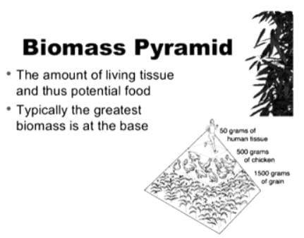
Which of the following ecosystems has the greatest biomass?
Detailed Solution: Question 12
Albedo of a surface is defined by the ratio of outgoing to incoming solar radiation. Keeping this in view, which of the following surface will have the highest albedo?
Detailed Solution: Question 13
Read the following statement and identify the corresponding soil forming processes
I. It is the process of removal of constituents in suspension or solution by percolating water from upper to lower layers.
II. It is the process of deposition of soil material in the lower layers
Detailed Solution: Question 14
Detailed Solution: Question 15
Which one of the following minerals in the Moh’s scale of hardness is a silicate?
Detailed Solution: Question 16
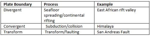
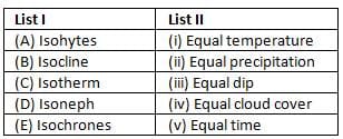
Match the following plate boundaries, tectonic processes and geographic examples
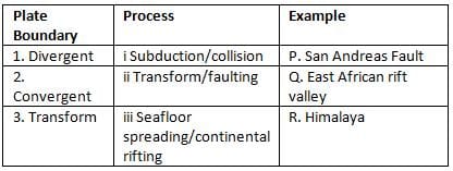
Detailed Solution: Question 17
Detailed Solution: Question 18
What is the percentage of the total area of the ocean that overlies the continental shelf?
Detailed Solution: Question 19
Detailed Solution: Question 20
Which of the following minerals commonly occurs in prismatic or elongated crystal form?
Detailed Solution: Question 21
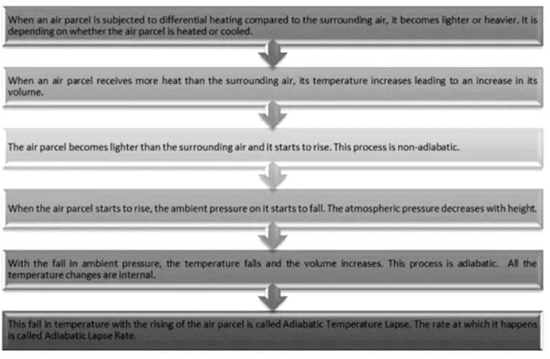
Arrange the correct sequence of the process of temperature decrease with increase in altitude.
i. The air parcel becomes lighter than the surrounding air and it starts to rise.
ii. Air parcel is subjected to differential heating compared to the surrounding air.
iii. Adiabatic Lapse Rate occurs.
iv. With the fall in ambient pressure, the temperature falls and the volume increases.
Detailed Solution: Question 22
Which of the following causes the dissipating stage of a thunderstorm?
Detailed Solution: Question 23
Which of the following does occur during La-Nina?
Detailed Solution: Question 24
The air mass type most likely to form thunderstorms is
Detailed Solution: Question 25
A bar running perpendicular to the coastline that connects the coast with a neighbouring island is known as
Detailed Solution: Question 26
Match and select the correct answer form the codes given below:
Detailed Solution: Question 27
Which of the following statement about river channel velocity is correct?
Detailed Solution: Question 28
The temperature and pressure at which the three phases of water co-exist known as the triple point occurs at the temperature of
Detailed Solution: Question 29
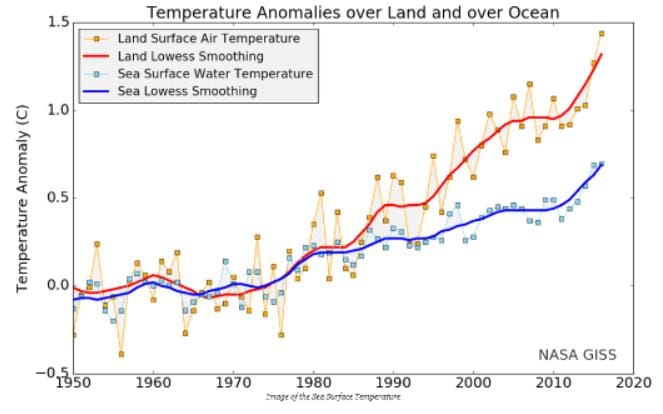
Overall, day to day variation in the sea surface temperature in the global oceans can have a maximum range of
Detailed Solution: Question 30