RPSC RAS (Rajasthan) Exam  >  RPSC RAS (Rajasthan) Tests  >  RAS RPSC Prelims Preparation - Notes, Study Material & Tests  >  Rajasthan Geography MCQ Test - RPSC RAS (Rajasthan) MCQ

Rajasthan Geography MCQ Test - RPSC RAS (Rajasthan) MCQ


Test Description

15 Questions MCQ Test RAS RPSC Prelims Preparation - Notes, Study Material & Tests - Rajasthan Geography MCQ Test

Rajasthan Geography MCQ Test for RPSC RAS (Rajasthan) 2024 is part of RAS RPSC Prelims Preparation - Notes, Study Material & Tests preparation. The Rajasthan Geography MCQ Test questions and answers have been prepared according to the RPSC RAS (Rajasthan) exam syllabus.The Rajasthan Geography MCQ Test MCQs are made for RPSC RAS (Rajasthan) 2024 Exam. Find important definitions, questions, notes, meanings, examples, exercises, MCQs and online tests for Rajasthan Geography MCQ Test below.
Solutions of Rajasthan Geography MCQ Test questions in English are available as part of our RAS RPSC Prelims Preparation - Notes, Study Material & Tests for RPSC RAS (Rajasthan) & Rajasthan Geography MCQ Test solutions in Hindi for RAS RPSC Prelims Preparation - Notes, Study Material & Tests course. Download more important topics, notes, lectures and mock test series for RPSC RAS (Rajasthan) Exam by signing up for free. Attempt Rajasthan Geography MCQ Test | 15 questions in 25 minutes | Mock test for RPSC RAS (Rajasthan) preparation | Free important questions MCQ to study RAS RPSC Prelims Preparation - Notes, Study Material & Tests for RPSC RAS (Rajasthan) Exam | Download free PDF with solutions
Rajasthan Geography MCQ Test - Question 1

The second highest percentage of Scheduled tribe population in Rajasthan is found in (2011) -

Detailed Solution for Rajasthan Geography MCQ Test - Question 1

The correct answer is Dungarpur District.
District-wise distribution of the tribal population

  • District-wise distribution of the tribal population shows that they have their highest concentration in Banswara district (72.3 percent), followed by 65.1 percent and 47.9 percent in Dungarpur and Udaipur districts respectively.
  • Nagaur ( 0.2 percent) preceded by Bikaner (0.4 percent) has the lowest share of tribal population in the total population.

​Rajasthan as per the 2011 census

  • The second major tribe, Bhil has a share of 99 percent of all ST population in Barmer district followed by Jaisalmer, Jodhpur, Rajsamand (95 percent) districts.
  • The Scheduled Tribes of the State have registered considerably lower sex ratio both in total as well as in the 0-6 yrs
    • As per the 2001 census, the Scheduled Tribe (ST) population of Rajasthan State is 7,097,706 constituting 8.4 percent of the total ST population of India.
  • The Scheduled Tribes of the State constitute 12.6 percent of the total population (56,507,188) of the State.
  • It holds 12th position among all States and UTs in respect of the percentage share of ST population to the total population.
  • The ST population has registered a growth rate of 29.6 percent during 1991-2001 which is 1.2 percent higher than the growth of the total population.
  • The Scheduled Tribes are overwhelmingly rural as 94.6 percent of them inhabit rural areas whereas 76.6 percent of the total population of the state live in villages.
Rajasthan Geography MCQ Test - Question 2

'Mawat' occurs due to

Detailed Solution for Rajasthan Geography MCQ Test - Question 2

The correct answer is western disturbances.

  • This is the period from mid-December to February.
  • During this period a high-pressure region develops in north-western India due to southward movements of the sun.
  • The Average Temperature Of This Region Is About 10c, Where As during the same period the temperature in south India remains at around 25c.
  • The wind blows from north-west to east and the N-E trade winds cause rainfall in the region of eastern coastal.
  • During this period the rainfall received from the Mediterranean western disturbances.
    • These are the temperate cyclones that are brought to India through Iraq, Iran, Afghanistan, and Pakistan by westerly jet streams. as they move towards the east they cause little rainfall.
  • In Punjab, they yield 25 cm rainfall whereas in western Uttar Pradesh they yield only 4cm of rainfall.
  • This rainfall is called Mawat in Rajasthan, It also helps the apple plantation in Himachal Pradesh.
1 Crore+ students have signed up on EduRev. Have you? Download the App
Rajasthan Geography MCQ Test - Question 3

Match the following irrigation projects and select your answer using the code given below:

Detailed Solution for Rajasthan Geography MCQ Test - Question 3

The Correct Answer is A-iii, B-iv, C-ii, D-i.

  • Bankli Dam is located on the river Sukri in Jalore District of Rajasthan.
  • Sukri river flows from the western slopes of Aravalli Range before merging with the Majal in Luni river
  • Som - Kamla - Amba is located in the Dungarpur district.
  • The Morel dam is situated near Kankariya village in Sawai Madhopur district of Rajasthan.
  • Jakham Dam is a dam located in Pratapgarh District in Rajasthan.
Rajasthan Geography MCQ Test - Question 4

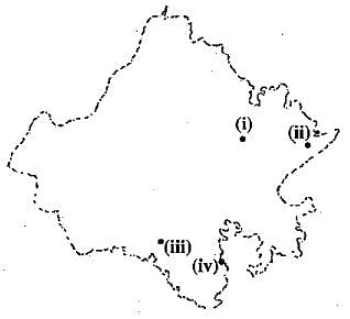
The following map is showing the location of wildlife sanctuaries in Rajasthan as i), ii), iii) and iv). Identify and answer the correct sequence as given below the map.
Detailed Solution for Rajasthan Geography MCQ Test - Question 4

The correct answer is Nahargarh, Bandberatha, Phulwari-ki-Nal, Sitamata.

  • Band Baretha Wildlife Sanctuary is an old wildlife reserve of the rulers of Bharatpur. In 1866, Maharaja Jaswant Singh started constructing a dam on the Kakund river which was completed by Maharaja Ram Singh in 1897. About 200 sq. km around the dam was declared a wildlife sanctuary in 1985. Band Baretha Wildlife Sanctuary is a bird watcher’s paradise. It has over 200 species of birds, including the elusive Black Britten. 
  • Nahargarh is a Village in Kishanganj Tehsil in the Baran district of Rajasthan. Nahargarh Fort was commissioned in the year 1734 by Maharaja Sawai Jai Singh II, the founder of Jaipur. This fort was originally named Sudarshangarh Fort.
  • Phulwari Ki Nal is a wildlife sanctuary located in the Udaipur district of Rajasthan. This sanctuary is extending right from Falna in Pali district to the Gogunda village in Udaipur district. The Phulwai Ki Nal was declared a wildlife sanctuary on 6 October 1983.
  • The Sita Mata Sanctuary provides rich pastures for a variety of deer including the four-horned Antelope (Chousingha). The sanctuary also acts as a home to other animals like wild boar, leopard, pangolin, fox, jackal, hyena, porcupine, jungle cat, and nilgai. The flying squirrel is the most attention-seeking animal in the Sita Mata Sanctuary.
Rajasthan Geography MCQ Test - Question 5

Consider the following statements about Jalipa - Kapurdi thermal power project of Rajasthan?
I. This power project is lignite based.
II. It has been installed by a private developer.
Which of the above statement is/are correct?

Detailed Solution for Rajasthan Geography MCQ Test - Question 5

The correct answer is Both I and II are correct.

  • JSW Barmer (Jalipa Kapurdi) power station is a coal-based thermal power plant located in Bhadresh village in Barmer district Rajasthan.
  • The power plant is operated by JSW Energy Limited.
  • The coal for the plant is sourced from Kapurdi and Jalipa mines.
  • Water for the power plant is sourced from Indira Gandhi Canal by constructing a 185 km pipeline.
Rajasthan Geography MCQ Test - Question 6

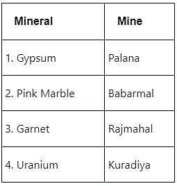
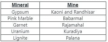
Identify the wrong pair:

Detailed Solution for Rajasthan Geography MCQ Test - Question 6

Rajasthan Geography MCQ Test - Question 7

Proposed oil refinery at Pachpadra, Barmer is a joint venture of

Detailed Solution for Rajasthan Geography MCQ Test - Question 7

The correct answer is HPCL and Government of Rajasthan.

  • Proposed oil refinery at Pachpadra, Barmer is a joint venture of HPCL and Government of Rajasthan.

Key Points:

  • Oil refinery at Pachpadra Rajasthan
  • The Pachpadra refinery project, also known as the Rajasthan refinery and petrochemical complex project (RRP).
  • The project is being executed by HPCL Rajasthan Refinery (HRRL), a joint venture between Hindustan Petroleum (HPCL, 74%) and the Government of Rajasthan (26%).
  • With a processing capacity of nine million tonnes of crude oil per annum (mtpa).
  • The refinery complex will produce environment-friendly clean fuel.
  • The construction of the Barmer refinery project was launched in January 2018 with the start of commercial operations expected by 2022.
  • It is expected to create employment opportunities for approximately 30,000 people.
Rajasthan Geography MCQ Test - Question 8

Which of the given hills is an extension of Vindhyan ranges in Rajasthan?

Detailed Solution for Rajasthan Geography MCQ Test - Question 8

The correct answer is Mukandara hills.

  • Mukandara hill is an extension of Vindhya ranges in Rajasthan.

Key Points

  • Mukandara hills
  • ​Mukundara Hills are located in the Hadoti region of Rajasthan.
  • This is surrounded by four rivers Ramzan, Ahu, Kali and Chambal and is situated between the two parallel mountains Mukundara and Gagrola.
  • It comes under the drainage area of ​​tributaries of Chambal river.
  • ​Mukundra Tiger Reserve
  • ​​Mukundra Tiger Reserve, popularly known as Darrah Wildlife Sanctuary, is spread across 4 districts – Bundi, Kota, Jhalawar & Chittorgarh.
  • It is located just 50 kilometres from Kota.
  • It is the 3rd tiger reserve in Rajasthan, after Ranthambore & Sariska Tiger Reserves.
Rajasthan Geography MCQ Test - Question 9

Which among the following are parts of the Thar desert?
(A) Godwar Tract
(B) Shekhawati Tract
(C) Banas Plain
(D) Ghaggar Plains

Detailed Solution for Rajasthan Geography MCQ Test - Question 9

The correct answer (A), (B), and (D)

Key Points

  • Western Sandy Plains of Rajasthan
  • On the basis of the existing relief features, Rajasthan has been divided into
  • The following physiographic divisions:
    • Western Sandy Plains: The Western Sandy Plains is subdivided into two units:
      • Sandy Arid Plains 
      • Marusthali
  • Semi-Arid Transitional Plains (Rajasthan Bagar)
    • Luni Basin (Godwar Tract)
    • Plain of Interior Drainage (Shekhawati Tract)
    • Ghaggar Plain
Rajasthan Geography MCQ Test - Question 10

Consider the following statements:
i) Since 2010, Rajasthan state occupies the first position in the country in the micro-irrigation process based on solar energy pumps.
ii) Rajasthan state occupies the first position in the country in harvesting wind energy.
iii) Till March 2013, 10,000 solar energy pumps have been established in Rajasthan.
Which of the above statement is/are correct?

Detailed Solution for Rajasthan Geography MCQ Test - Question 10

The correct answer is I only.

  • Since 2010, Rajasthan state occupies the first position in the country in the micro-irrigation process based on solar energy pumps.

Key Points

  • Solar Water Pump Programme 
  • Solar pump along with micro-irrigation systems scheme was started in Rajasthan in the year 2010-11.
  • Farmers who install micro-irrigation systems (Drip, Mini Sprinkler, and Sprinkler) on their fields are only eligible for the solar pump subsidy.
  • Department of Horticulture is the Implementing Agency and the Director, Horticulture is the Mission Director of the State. 
  • Since 2010, Rajasthan state occupies the first position in the country in the micro-irrigation process based on solar energy pumps. Hence statement 1 is correct.

4 stages of the scheme:

  • ​1st stage
    ​50 pumps (2010-2011)
  • 2nd stage
    500 pumps (2011-2012)​
  • 3rd stage
    ​​2200 pumps (2012-2013). Hence statement 3 is not correct.
  • ​4th stage
    ​​10000 pumps (2013-2018)
Rajasthan Geography MCQ Test - Question 11

Dholpur Power Project will be based on 

Detailed Solution for Rajasthan Geography MCQ Test - Question 11

Dholpur Combined Cycle Power Station is a gas-based thermal power plant located near Dholpur, Rajasthan.

Rajasthan Geography MCQ Test - Question 12

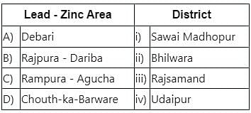
Match the following and select the correct answer using the code given below:
Detailed Solution for Rajasthan Geography MCQ Test - Question 12

The correct answer is A-iv, B-iii, C-ii, D-i

  • Debari : Udaipur
  • Rajpura - Dariba : Rajsamand
  • Rampura - Agucha : Bhilwara
  • Chouth-ka-Barware : Sawai Madhopur
Rajasthan Geography MCQ Test - Question 13

In Rajasthan, the monsoon winds of alternation that Time ? 

Detailed Solution for Rajasthan Geography MCQ Test - Question 13
The climate of the Rajasthan is very odd. There is a great diversity during the seasons in the Rajasthan. The climate of the Rajasthan is divided into three major seasons –
(i) The Hot Weather Season (March to June)
(ii) The Rainy Season (July to September)
(iii) The Cold Weather Season (October to February)
Rajasthan Geography MCQ Test - Question 14

In the following , depending on the filling capacity of the state of Rajasthan is the largest Dam ? 

Detailed Solution for Rajasthan Geography MCQ Test - Question 14
The Ranapratap Sagar Dam is a gravity masonry dam of 53.8 meters (177 ft) height built on the Chambal River at Rawatbhata in Rajasthan in India. It is part of integrated scheme of a cascade development of the river involving four projects starting with the Gandhi Sagar Dam in the upstream reach (48 kilometres (30 mi) upstream) in Madhya Pradesh and the Jawahar Sagar Dam on the downstream (28 kilometres (17 mi) downstream) with a terminal structure of the Kota Barrage (28 kilometres (17 mi) further downstream) in Rajasthan for irrigation.
Rajasthan Geography MCQ Test - Question 15

Which of the following in peanut production in the field of space ‘ of Rajasthan , Rajkot , ” called ? 

Detailed Solution for Rajasthan Geography MCQ Test - Question 15
  • Lunkaransar is a town in the Bikaner district of Indian state of Rajasthan. Lunkaransar lake in Rajasthan is a playa lake formed due to deflation.
  • It is also the headquarters of the tehsil in the Bikaner Sub-division with the same name. Salt is called "Lun" in the local language. There once was a salt lake at this location. It is dry now. Lunkaransar is located on the Bikaner-Sri Ganganagar road (National Highway 62). It is famous for peanut crop production.therefore it is called Rajkot of Rajasthan. Its land and weather are suitable for oily crops. Jojoba plantation has been established. A Government olive oil refinery also been established. An olive oil plantation of 500 hectares is in production.
109 docs|21 tests
Information about Rajasthan Geography MCQ Test Page
In this test you can find the Exam questions for Rajasthan Geography MCQ Test solved & explained in the simplest way possible. Besides giving Questions and answers for Rajasthan Geography MCQ Test, EduRev gives you an ample number of Online tests for practice

Top Courses for RPSC RAS (Rajasthan)

Download as PDF

Top Courses for RPSC RAS (Rajasthan)