TS SET Paper 2 Mock Test - 10 (Geography) - TS TET MCQ
30 Questions MCQ Test TS SET Mock Test Series 2024 - TS SET Paper 2 Mock Test - 10 (Geography)
Which one of the following is a major plate?
Which of the following is the cause of tides?
A. Moon's gravitational pull
B. Sun's gravitational pull
C. Centrifugal force
D. Gravitational pull of Earth
Select the answer from the codes given below :
| 1 Crore+ students have signed up on EduRev. Have you? Download the App |
The organisations lay stress on liberalisation of foreign trade and foreign investment is
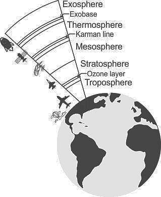
In which layer the maximum part of the atmosphere (by mass) is found?
Given below are two statements. One is labelled as Assertion (A) and the other is labelled as Reason (R).
Assertion(A) : Unsupervised Classification normally requires only a minimal amount of input from the analyst.Reason(R) : A priori knowledge of the scene or training sites are required to run this classification.
Select the correct answer from options given below :
What is the correct sequence of occurrence of various atmospheric layers from earth's surface?
1. Exosphere
2. Stratosphere
3. Troposphere
Choose the correct answer from the options given below
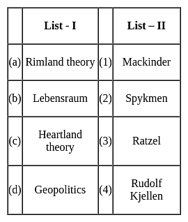
Assertion (A)- Spykman argued that the Heartland theory appeared less important than the Rimland.
Reason (R)- Mackinder presented his model at the end of the railway age and did not mention about the superiority of air navigation as well as the railways.
Choose the correct option:
Given below are two statements. One is labelled as Assertion (A) and the other is labelled as Reason (R).
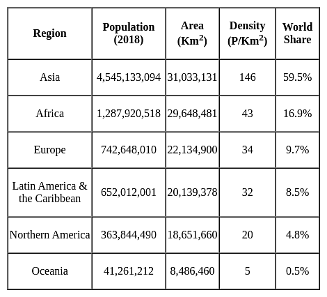
Assertion (A): There is high density of population in Chotanagpur plateau.
Reason (R) : Various minerals are found in the Chotanagpur plateau.
Select the correct answer from options given below:
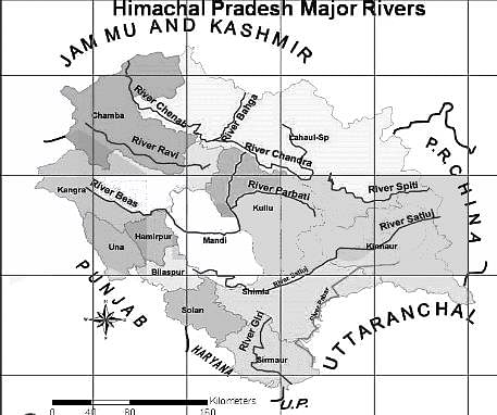
Through which state do the rivers Chenab, Ravi, Beas, Sutlej and Yamuna flow?
(a) The theory is similar to Growth Pole Theory by Francis Perroux.
(b) Development poles are urban centers with many economic activities which are diversified in nature.
(c) The central town is the supplier of commodities for consumption.
(d) The central district provides raw material to the peripheral towns.
Select the correct answer from the codes given below:
i. Remote sensing is used in crop acreages estimation
ii. Different methods of remote sensing are used in soil categorization.
iii. Remote sensing is used in lithological discrimination
iv. Various methods of remote sensing are also used in major river valley projects. .
Given below are two statements, one labelled as assertion(A) and other labelled as reason(R).
Assertion(A)- Aerial photographs are more useful when spatial detail is more critical than spectral information.
Reason(R)- Aerial photograph’s spectral resolution is generally coarse.
Match the List - I with List - II and select the correct answer from the code given below :

Which of the following states is sole producer of agate, chalk, and perlite in India?
Assertion(A)- According to Anthony Giddens human agency and social structure are not two separate concepts.
Reason(R)- Structure is a continuous process which is carried out in a flow.
Select the correct answer from options given below:
Match the concepts (List - I) with their proponents (List - II) selecting correct answer from the codes given below :

The cadastral maps, topographical maps and the city plans come under the category of
|
60 tests
|


