TS TET Exam  >  TS TET Tests  >  TS SET Mock Test Series 2024  >  TS SET Paper 2 Mock Test - 8 (Geography) - TS TET MCQ

TS SET Paper 2 Mock Test - 8 (Geography) - TS TET MCQ


Test Description

30 Questions MCQ Test TS SET Mock Test Series 2024 - TS SET Paper 2 Mock Test - 8 (Geography)

TS SET Paper 2 Mock Test - 8 (Geography) for TS TET 2024 is part of TS SET Mock Test Series 2024 preparation. The TS SET Paper 2 Mock Test - 8 (Geography) questions and answers have been prepared according to the TS TET exam syllabus.The TS SET Paper 2 Mock Test - 8 (Geography) MCQs are made for TS TET 2024 Exam. Find important definitions, questions, notes, meanings, examples, exercises, MCQs and online tests for TS SET Paper 2 Mock Test - 8 (Geography) below.
Solutions of TS SET Paper 2 Mock Test - 8 (Geography) questions in English are available as part of our TS SET Mock Test Series 2024 for TS TET & TS SET Paper 2 Mock Test - 8 (Geography) solutions in Hindi for TS SET Mock Test Series 2024 course. Download more important topics, notes, lectures and mock test series for TS TET Exam by signing up for free. Attempt TS SET Paper 2 Mock Test - 8 (Geography) | 100 questions in 120 minutes | Mock test for TS TET preparation | Free important questions MCQ to study TS SET Mock Test Series 2024 for TS TET Exam | Download free PDF with solutions
TS SET Paper 2 Mock Test - 8 (Geography) - Question 1

Which of the following satellites are able to observe the whole earth including pole?

Detailed Solution for TS SET Paper 2 Mock Test - 8 (Geography) - Question 1
Important Points

Hence, the correct answer is ​Polar orbital satellite

TS SET Paper 2 Mock Test - 8 (Geography) - Question 2

Which one of the following is the narrow belt parallel to the Shiwalik foothills where streams and rivers coming from the mountains deposit heavy materials of rocks and boulders? 

Detailed Solution for TS SET Paper 2 Mock Test - 8 (Geography) - Question 2

The correct answer is Bhabar.

Key Points

  • At the break of the Bhabar escarpment, there is a narrow belt of 8-10 km parallel to the Shiwalik foothills.
    • As a result, streams and rivers coming from the mountains deposit heavy materials of rocks and stones and sometimes disappear in the region.
  • South of the Bhabar is the Terai belt, approximately 10–20 km wide, where most of the streams and rivers re-emerge without any properly demarcated channel, giving rise to marshy and swampy conditions, known as the Terai.

Additional Information

  • To the south of the Terai is a belt composed of older and younger alluvial deposits known as Bhangar and Khadar respectively.
    • These plains are characterized by mature river erosion and depositional landforms, such as sand ridges, meanders, oxbow lakes, and braided channels.
    • The Brahmaputra plain is known for its river islands and sand bars.
    • Most of these areas are subject to periodic floods and river courses change, creating small streams.
1 Crore+ students have signed up on EduRev. Have you? Download the App
TS SET Paper 2 Mock Test - 8 (Geography) - Question 3

With reference to the water on the planet Earth, consider the following statements :

1. The amount of water in the rivers and lakes is more than the amount of groundwater.

2. The amount of water in polar ice caps and glaciers is more than the amount of groundwater.

Which of the statements given above is/are correct ?

Detailed Solution for TS SET Paper 2 Mock Test - 8 (Geography) - Question 3

The correct answer is 2 only.

Key Points

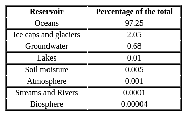
  • Distribution of water on the surface of the earth:
  • Water in groundwater is 0.62% while in lakes and rivers it is 0.008 (Salt lakes)+0.009(freshwater lakes) + 0.0001(rivers)=0.0171. Hence, statement 1 is not correct.
  • Water in polar ice caps and glaciers is 2% while in groundwater it is 0.62%. Hence, statement 2 is correct.
TS SET Paper 2 Mock Test - 8 (Geography) - Question 4
______ is the largest slum in Asia.
Detailed Solution for TS SET Paper 2 Mock Test - 8 (Geography) - Question 4

The correct answer is Dharavi

Key Points

  • Dharavi is a locality in Mumbai, Maharashtra, India, considered to be one of Asia's largest slums.
  • Dharavi has an area of just over 2.1 square kilometers and a population of about 1,000,000.
  • With a population density of over 277,136/km2, Dharavi is one of the most densely populated areas in the world.
  • The Dharavi slum was founded in 1884 during the British colonial era.
  • It grew because of the expulsion of factories and residents from the peninsular city center by the colonial government and from the migration of rural Indians into urban Mumbai.
  • For this reason, Dharavi is currently a highly diverse settlement religiously and ethnically.
  • Dharavi has an active informal economy in which numerous household enterprises employ many of the slum residents such as leather, textiles, and pottery products are among the goods made inside Dharavi.
  • Dharavi has suffered from many epidemics and other disasters, including a widespread plague in 1896 which killed over half of the population of Mumbai.
  • Sanitation in the slums remains poor.
TS SET Paper 2 Mock Test - 8 (Geography) - Question 5

Match List-I with List-II

Code:

Detailed Solution for TS SET Paper 2 Mock Test - 8 (Geography) - Question 5
  • Vidal de La Blache was a famous French geographer who founded the school of human geography. He was also of the opinion that it was unreasonable to draw boundaries between physical and human phenomenon.
  • Albert Penck was the first geographer to coin the term ‘Geomorphology’.
  • He was also one of the two scientists to discover and name four ice ages of European Pleistocene period.
  • Alexander von Humboldt travelled extensively throughout the world and focused on physical geography. He also emphasized the difference between lifestyle of people as per their different environments.
  • Elisee Reclus was a disciple of Carl Ritter. He was interested in systematic physical geography which he called la Terre.

Thus, the correct answer is C.

TS SET Paper 2 Mock Test - 8 (Geography) - Question 6
The classical theory of Indian Monsoon was explained by
Detailed Solution for TS SET Paper 2 Mock Test - 8 (Geography) - Question 6

 Although there are mentions of Indian Monsoon in the Rig Veda and Al Masudi’s works, the concept of Indian Monsoon was explained in 1686 by Sir Edmund Halley. Halley said that monsoon resulted due to thermal contrast between continents and oceans because of differential heating.

Thus, the correct answer is B.

TS SET Paper 2 Mock Test - 8 (Geography) - Question 7
Which one of the following in the leading producer of coffee?
Detailed Solution for TS SET Paper 2 Mock Test - 8 (Geography) - Question 7

The correct answer is Karnataka.

Key Points

  • The state of Karnataka is the leading producer of coffee in India.
  • Karnataka is the country's largest coffee-producing state, accounting for nearly 71 per cent.
  • The Karnataka districts of Chikmagalur, Kodagu, and Hassan are major coffee-producing regions of the state. 
  • In the latest financial year, Karnataka produced 2.33 Lakh Metric Tonnes of coffee.
  • In Karnataka, coffee is cultivated in a wide area and accounts for over 60 % of the total area under coffee cultivation in India.
  • The key factors for the production of coffee in large quantities in Karnataka is the required temperature, climate, and rainfall.

Additional Information

  • Kerala:​
    • Arabica and Robusta coffee beans are grown in the Malabar region of Kerala.
    • Kerala, across the hills of the Wayanad district near Kalpetta, accounts for 21% of India's coffee production. 
  • Tamil Nadu:
    • The state of Tamil Nadu accounts for 5% of India's total coffee production in the Nilgiris District, Yercaud, and Kodaikanal.
    • In the Eastern Ghats, the Shevaroy Hills have many old coffee plantations in Tamil Nadu.
  • Maharashtra:
    • Maharashtra's Chikhaldara Hill Station is the only coffee-growing area in Maharashtra and a must-see destination to visit from October to June.
TS SET Paper 2 Mock Test - 8 (Geography) - Question 8

Consider the following statements regarding plate tectonics

1. Mid Ocean ridges and Rift Valley are characteristics of divergent plate boundaries

2. Convergent plate boundaries are constructive in nature.

3. San Andreas Fault is an example of Transform Plate boundary.

4. Zone of Subduction is associated with Divergent Plates.

Which of the is/are correct

Detailed Solution for TS SET Paper 2 Mock Test - 8 (Geography) - Question 8

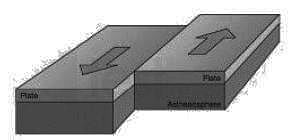
There are three ways in which the plates interact with each other

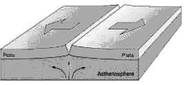
Divergent Plates:

  • Mid-ocean ridges are formed due to this kind of interaction. Here, the basaltic magma erupts and moves apart. On continents, East African Rift Valley is the most important geomorphological feature formed due to the divergence of African and Somali plates.
  • Divergent edges are sites of earth crust formation hence they are called as constructive edges, and volcanic earth forms are common along such edges.

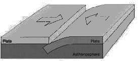
Convergent Plate:

  • The zone of collision may undergo crumpling and folding, and folded mountains may emerge. Himalayan Boundary Fault is one such example.
  • When one of the plates is an oceanic plate, it gets embedded in the softer asthenosphere of the continental plate, and as a result, trenches are formed at the zone of subduction.
  • Near the convergent edge a part of the crust is destroyed, hence the name Destructive Edge

​Transform Plate:

  • In this kind of interaction, two plates slide past each other, and there is no creation or destruction of the landform but only deformation of the existing landform.
  • In oceans, transform faults are the planes of separation generally perpendicular to the mid-oceanic ridges. The San Andreas Fault along the western coast of the USA is the best example

TS SET Paper 2 Mock Test - 8 (Geography) - Question 9
The systematic description of climatic conditions and climatic changes in the geological history of earth is known as -
Detailed Solution for TS SET Paper 2 Mock Test - 8 (Geography) - Question 9

Climochronology is the description of the past climates of each period of the earth's history. The reconstruction of palaeoclimates, i.e., climochronology means rearranging of the climatic history of the globe or part, on the basis of indicators of palaeoclimates.

TS SET Paper 2 Mock Test - 8 (Geography) - Question 10
Which of the following is NOT a reason for a glacial lake outburst flood?
Detailed Solution for TS SET Paper 2 Mock Test - 8 (Geography) - Question 10

The Glacial Lake outburst flow (GLOF) occurs when the dam that contains the glacial lake falls. It can occur due to an avalanche of heavy snow and rock, an earthquake or volcanic eruption under the ice, erosion, pressure due to buildup of water, etc.

TS SET Paper 2 Mock Test - 8 (Geography) - Question 11
Which one of the following crops is generally benefitted by the rain caused by western disturbances in India?
Detailed Solution for TS SET Paper 2 Mock Test - 8 (Geography) - Question 11

The correct answer is Wheat.

Key Points

  • Winter rainfall and agriculture:
    • Western disturbances originate from the Mediterranean Sea and come to India.
    • It causes rainfall in states like Haryana, Punjab, Jammu and Kashmir, Himachal Pradesh, Uttarakhand during winter.
    • Precipitation during the winter season is of great importance in agriculture, especially for Rabi crops including wheat, which is one of the most important Indian crops.
    • The major Rabi crop in India is wheat, followed by barley, mustard, sesame and peas.
    • The rains caused by western disturbances have a direct impact on the economy of wheat-producing states like Haryana and Punjab.

Additional Information

  • The Indian crop season is classified into two major seasons:
    • Kharif crops:
      • Dependent on monsoon and their crop season runs from July to October.
      • Examples include rice, maize, millet, ragi, pulses, soybean, groundnut etc.
    • Rabi crops:
      • Sown in winter after the monsoon rains end and harvested in summer, their crop season runs from October to April.
      • Examples include wheat, barley, rapeseed, oats, gram, flax, etc.
TS SET Paper 2 Mock Test - 8 (Geography) - Question 12

Consider the following statements and choose the correct answer from the options given below.

Statement I: Integration of the national economy with the world economy encourages the free flow of goods and services.

Statement II: Liberalisation aims to unlock the economic potential of the country by encouraging the private sector and multinational corporations to invest and expand

Detailed Solution for TS SET Paper 2 Mock Test - 8 (Geography) - Question 12

Key Points

Globalization:

  • Globalization essentially means the integration of the national economy with the world economy.
  • It implies a free flow of information, ideas, technology, goods and services, capital, and even people across different countries and societies.
  • It increases connectivity between different markets in the form of trade, investments, and cultural exchanges.
  • The concept of globalization has been explained by the IMF (International Monetary Fund) as ‘the growing economic interdependence of countries worldwide through increasing volume and variety of cross border transactions in goods and services and of international capital flows and also through the more rapid and widespread diffusion of technology.

Hence, the statement I is correct.

Liberalization:

  • Liberalization refers to the slackening of government regulations.
  • It implies greater autonomy to the business enterprises in decision-making and removal of government interference.
  • It was believed that the market forces of demand and supply would automatically operate to bring about greater efficiency and the economy would recover.
  • This was to be done internally by introducing reforms in the real and financial sectors of the economy and externally by relaxing state control on foreign investments and trade.
  • Liberalization aims to unlock the economic potential of the country by encouraging the private sector and multinational corporations to invest and expand.

Hence, statement II is also correct.

Therefore, both the statements are correct here.

TS SET Paper 2 Mock Test - 8 (Geography) - Question 13
Which of the following is NOT a characteristic of Absteigende Entwickelung or waning rate of development in the geomorphic cycle of Penck?
Detailed Solution for TS SET Paper 2 Mock Test - 8 (Geography) - Question 13

Penck’s geomorphic model divides the geomorphic process into three stage- Aufsteigende Entwickelung(waxing or accelerated development), Gleichformige Entwickelung(uniform development) and Absteigende Entwickelung(waning or decreasing rate development). The waning rate of development shows lateral erosion, absence of upliftment and decline in landforms. Vertical erosion is observed in the Aufsteigende Entwickelun or waxing rate of development.

Thus, the Correct answer is D.

TS SET Paper 2 Mock Test - 8 (Geography) - Question 14
Which one of the following factors determines the interaction between humans and the environment?
Detailed Solution for TS SET Paper 2 Mock Test - 8 (Geography) - Question 14

Human beings interact with their physical environment with the help of technology.

  • Technology indicates the level of cultural development of society. Human beings were able to develop technology after they developed a better understanding of natural laws.
  • For example, the understanding of concepts of friction and heat helped us discover fire. Similarly, understanding of the secrets of DNA and genetics enabled us to conquer many diseases.
TS SET Paper 2 Mock Test - 8 (Geography) - Question 15
Which of the following are cruciform settlements?
Detailed Solution for TS SET Paper 2 Mock Test - 8 (Geography) - Question 15

The correct answer is 1 and 2 Both options.

Key Points

Cruciform settlements

  • T-shaped and Y-shaped both are Cross-shaped or cruciform settlements.
  • T -shaped settlements develop at tri-junctions of the roads.
  • While Y-shaped settlements emerge as the places where two roads converge on the third one and houses are built along these roads.
  • Cruciform settlements develop on the cross-roads and houses extend in

​Y-shaped settlement

All the rural settlements:

TS SET Paper 2 Mock Test - 8 (Geography) - Question 16

Bundestag' and 'Bundesrat are the two Houses of Legislature in

Detailed Solution for TS SET Paper 2 Mock Test - 8 (Geography) - Question 16

The correct answer is Germany.

  • Bundestag and Bundesrat are the two Houses of Legislature in Germany.

Key Points

  • The German Bundesrat is the constitutional body through which the states participate in the legislative process.
  • Elections for the Bundestag take place every four years.
  • Seats are allocated according to a personalized proportional voting system that combines a personal vote for a particular candidate in a district (first vote) with a party vote (second vote).

Additional Information

  • Features we took from Germany
    • Fundamental Rights are suspended during Emergency.
TS SET Paper 2 Mock Test - 8 (Geography) - Question 17
Shifting cultivation is known as ______ in Vietnam.
Detailed Solution for TS SET Paper 2 Mock Test - 8 (Geography) - Question 17

Shifting cultivation is a primitive type of agriculture, still practiced around the world. In this system, the patch of forest or vegetation is burnt to make room for agricultural land. The land is abandoned after a few years and new land is selected. The abandoned patch of land is used again after its fertility is restored naturally. This type of cultivation is mostly done by nomadic people. It has different names in different parts of the world. It is called as Jhum in North-East India, Kumari in Western Ghats of Kerala, Podu in Andhra Pradesh and Dhavi, Kaman and Vinga in Odisha. Around the world, it has names like Masole in Congo, Ladang in Java & Indonesia, Roka in Brazil, Ray in Vietnam, etc.

Thus, the correct answer is B.

TS SET Paper 2 Mock Test - 8 (Geography) - Question 18

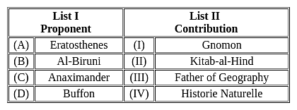
Match List I and List II:

Choose the correct answer from the options given below:

Detailed Solution for TS SET Paper 2 Mock Test - 8 (Geography) - Question 18

Correct Answer: (A) - (III), (B) - (II), (C) - (I), (D) - (IV).

Key Points

TS SET Paper 2 Mock Test - 8 (Geography) - Question 19
The Zenith is/are
Detailed Solution for TS SET Paper 2 Mock Test - 8 (Geography) - Question 19

Explanation:

Zenith:

  • If a plumb line through an observer is extended upward, the imaginary point at which it appears to intersect the celestial sphere is known as Zenith.

Additional Information

Nadir point:

  • The imaginary point at which it appears to intersect downward in the celestial sphere is known as Nadir.
  •  

Pole:

  • If the axis of rotation of the earth is imagined to be extended infinitely in both directions, the points at which it meets the celestial sphere are known as poles.
  • The point of intersection in the northern hemisphere is known as the north celestial pole and that in the southern hemisphere as the south celestial pole.

Celestial point:

  • An imaginary sphere of infinite radius with the earth at its center and other celestial bodies studded on its inside surface is known as the celestial sphere.
TS SET Paper 2 Mock Test - 8 (Geography) - Question 20
Which of the following is NOT an essential characteristic of ecological succession?
Detailed Solution for TS SET Paper 2 Mock Test - 8 (Geography) - Question 20

Answer: Option 4) Static and unchanging nature of communities

Ecological succession is a natural process that describes the gradual and predictable changes in the composition of species in a community over time. It is characterized by the sequential replacement of one community by another until a stable climax community is established.

Key Points
Essential Characteristics of Ecological Succession:
  • Orderly and sequential change in communities: Ecological succession is a gradual and orderly process, where each stage prepares the environment for the next stage.
  • Replacement of one community by another: Succession involves the gradual replacement of one community by another, as species adapt and compete for resources.
  • Development of a stable climax community: Succession ultimately leads to the establishment of a stable climax community, which is adapted to the specific environmental conditions.
Non-Essential Characteristic:
  • Static and unchanging nature of communities: This statement is not an essential characteristic of ecological succession. Ecological communities are dynamic and undergo constant change in response to environmental factors, disturbances, and species interactions.
Additional Information
Orderly and sequential change in communities: This is an essential characteristic of ecological succession, as it describes the gradual and predictable changes in the composition of species over time.
Replacement of one community by another: This is also an essential characteristic of ecological succession, as it involves the gradual replacement of one community by another, as species adapt and compete for resources.
Development of a stable climax community: This is an essential characteristic of ecological succession, as it ultimately leads to the establishment of a stable climax community, which is adapted to the specific environmental conditions.
Therefore, among the given options, option 4) Static and unchanging nature of communities is not an essential characteristic of ecological succession.
Important Points
  • The rate and direction of ecological succession can be influenced by various factors, such as climate, soil conditions, disturbances, and the availability of resources.
  • Understanding ecological succession is important for managing and conserving ecosystems, as it helps us predict how communities will respond to environmental changes and disturbances.
TS SET Paper 2 Mock Test - 8 (Geography) - Question 21
what is the main factor responsible for the survival and growth of a biotic community in its environment?
Detailed Solution for TS SET Paper 2 Mock Test - 8 (Geography) - Question 21
Answer: Option 1) Ecological Factors.
The survival and growth of a biotic community in its environment is influenced by a complex interplay of various factors. Among these factors, ecological factors play a crucial role in shaping the structure and dynamics of biotic communities.
Key Points
  • Main Factor Responsible for Survival and Growth is Ecological factors: Ecological factors are the primary determinants of the survival and growth of a biotic community in its environment. These factors include both biotic factors (living organisms) and abiotic factors (non-living components).
  • Biotic factors: These include interactions between organisms such as competition, predation, parasitism, and mutualism. These interactions can directly or indirectly affect the survival and growth of individual species and the overall community structure.
  • Abiotic factors: These include physical and chemical components of the environment such as temperature, water availability, light intensity, pH, and soil conditions. These factors can influence the distribution, abundance, and growth of organisms in a community.
  • Ecological factors can vary across different habitats and ecosystems, leading to diverse biotic communities adapted to specific environmental conditions.
  • Human activities, such as pollution, climate change, and habitat destruction, can significantly alter ecological factors, leading to changes in biotic communities and potential threats to their survival and growth.
Additional Information
  • Physical space: While physical space is necessary for the survival of a biotic community, it is not the main factor responsible for its growth and development. The availability of resources and the interactions between organisms within the community play a more significant role in determining its success.
  • Niche: A niche represents the specific role and position of an organism within an ecosystem. While the concept of niche is important for understanding the survival of individual species, it does not encompass the broader interactions and processes that determine the growth and dynamics of the entire biotic community.
  • Trophic level: Trophic levels describe the feeding relationships between organisms in an ecosystem. While trophic interactions can influence the abundance and distribution of species, they are not the primary driver of the overall survival and growth of the biotic community.
TS SET Paper 2 Mock Test - 8 (Geography) - Question 22

Which of the following statements are correct about the continental drift theory?

1. Wegner aims to explain the relation between past climatic change and the displacement of the continents

2. The supercontinent Pangea breakdown into Laurasia and Gondwanaland.

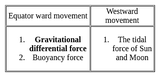
3. Differential gravitational forces are responsible for the displacement

Detailed Solution for TS SET Paper 2 Mock Test - 8 (Geography) - Question 22

Continental drift: it is the displacement of crustal blocks/ continental blocks from their previous location over a period of time

Introduction to Continental Drift Theory:

  • He was a German polar researcher Meteorologist, Geophysicist
  • His concept of continental drift was published in the book entitled ‘Die Entstehung der Kontinente and Ozeane’
  • This theory was propounded in the year 1912
  • It came to light after 1922
  • It translated from the German language to English in 1924

Continental Drift Theory:

  • In this theory, Wegner aims to explain the relation between past climatic change and the displacement of the continents
  • There are two types of displacement of continents

  • According to Wegener, all the continents were one single continental mass (called a Super Continent) – Pangaea
  • A Mega Ocean surrounded this supercontinent, known by the name Panthalassa.
  • Although Wegener’s initial theory did not cover mantle convection until Arthur Holmes later proposed the theory.
  • The supercontinent was named Pangaea (Pangea) and the Mega-ocean was called Panthalassa.
  • According to this theory, the supercontinent, Pangaea, began to split some two hundred million years back.
  • Pangaea first split into 2 big continental masses known as Gondwanaland and Laurasia forming the southern and northern modules respectively.
  • Later, Gondwanaland and Laurasia continued to break into several smaller continents that exist today.

From the above discussion, it is clear that all the statements are true in the context of Continental Drift Theory.

TS SET Paper 2 Mock Test - 8 (Geography) - Question 23
Water movement caused by meteorological effects (winds and atmospheric pressure changes) is referred to as:
Detailed Solution for TS SET Paper 2 Mock Test - 8 (Geography) - Question 23

The correct answer is Surges.

Key Points

  • The rhythmic rise and fall of ocean water twice a day is called tide.
  • The periodical rise and fall of the sea level, once or twice a day, is mainly due to the attraction of the sun and the moon.
  • The movement of water caused by meteorological effects (winds and atmospheric pressure changes) is called Surges (storm surges during cyclones).
  • A tropical cyclone brings very violent winds, torrential rain, high waves, and, in some cases, very destructive storm surges and coastal flooding.

Additional Information

  • Wave Front:
    • A wavefront is a set or locus of all points at a particular instant of time, having the same phase.
    • Wavefronts are imaginary surfaces to represent how waves move in 2-dimensional space.
  • Ocean Front:
    • In oceanography, a front is a boundary between two distinct water masses.
    • The formation of fronts depends on multiple physical processes and small differences in these lead to a wide range of front types.
TS SET Paper 2 Mock Test - 8 (Geography) - Question 24

Which of the following statements(s) concerning natural regions of the world is/are correct?

1) Equatorial climatic regions have less urbanization

2) Mediterranean climatic regions have a high level of urbanization

3) Equatorial climatic regions have a high concentration of human population

4) Mediterranean climatic regions practice plantation farming

Select the correct answer using the code given below:

Detailed Solution for TS SET Paper 2 Mock Test - 8 (Geography) - Question 24

The correct answer is 1, ​2 and 4 are correct.

Key Points

  • Equatorial climatic regions have less urbanization because of the lack of favorable weather conditions for growing crops or industrial development. Hence, statement 1 is correct.
  • Mediterranean climatic regions have a high level of urbanization because the climate is more favorable for growing crops and plantations.
  • The Mediterranean lands are also known as the world's orchard lands because a wide range of citrus fruits and grapefruits are grown here. The Olive tree is most probably typical of the Mediterranean cultivated vegetation. Hence, statements 2 and 4 are correct.
  • Mediterranean climate is confined to the Western portions of Continental masses between 30 degrees and 45 degrees north and south of the equator.
  • The basic cause of the Mediterranean climate is the shifting of wind belts.
  • Equatorial climatic regions are mostly comprised of developing nations like the countries in Amazon Basin (South America), the Congo Basin (Africa), Malaysia, Indonesia, etc.
    • The concentration of the human population in these regions is low because of the unpleasant weather conditions. Hence, Statement 3 is NOT correct.
TS SET Paper 2 Mock Test - 8 (Geography) - Question 25
Cultural modification of an individual, group or people by adapting to or borrowing traits from another culture is known as:
Detailed Solution for TS SET Paper 2 Mock Test - 8 (Geography) - Question 25

Cultural modification of an individual, group, or people by adapting to or borrowing traits from another culture is known as Acculturation.

Key Points

Acculturation:

  • Cultural modification of an individual, group, or people by adapting to, or borrowing traits from, another culture.
  • A merging of cultures as a result of prolonged contact.
  • It should be noted that individuals from culturally diverse groups may desire varying degrees of acculturation into the dominant culture.
  • The definition of acculturation is the transfer of values and customs from one group to another.
  • Japanese people dressing in Western clothing is an example of acculturation.
  • The modification of the culture of a group or individual as a result of contact with a different culture.

Additional InformationCultural Lag: a relatively slower advance or change of one aspect of a culture

Cultural Pluralism: Cultural pluralism is defined as the societal condition in which minority groups within a society can maintain their distinctive cultural identities, values, and practices provided that they are consistent with the laws and values of the wider society.

Assimilation: Assuming the cultural traditions of a given people or group.

TS SET Paper 2 Mock Test - 8 (Geography) - Question 26
Which of the following best defines the term 'dichotomy'?
Detailed Solution for TS SET Paper 2 Mock Test - 8 (Geography) - Question 26

The correct answer is A division or contrast between two things that are or are represented as being opposed or entirely different.
Key Points

A dichotomy is a division or contrast between two things that are or are represented as being opposed or entirely different.

"Dichotomy" in geographical thought often refers to the perceived binary opposition between two distinct elements or ideas. Here are two classic examples:

Environmental Determinism vs. Possibilism:

  • This is perhaps one of the most well-known dichotomies in geography.
  • Environmental determinism suggests that the physical environment sets hard limits on human activity, essentially determining the course of human history and cultural development.
  • On the other hand, possibilism posits that while the environment sets certain constraints, human agency plays a significant role in determining the paths that societies can take.

Physical vs. Human Geography:

  • Another dichotomy in the field of geography is the division between physical and human geography.
  • Physical geography focuses on understanding the Earth's physical landscape and processes, such as climate, landforms, and ecosystems.
  • In contrast, human geography concentrates on human activities, cultures, societies, and their impacts on the physical landscape. While this dichotomy exists, contemporary geographical thought recognizes the interplay between the two.

It's important to note that dichotomies, while useful for organizing ideas, can oversimplify complex relationships. In reality, concepts often exist along a spectrum rather than in binary opposition. This is especially true in geography, where physical and human elements are deeply intertwined

TS SET Paper 2 Mock Test - 8 (Geography) - Question 27

Parts of earth which are directly expose to moon have pull which is

Detailed Solution for TS SET Paper 2 Mock Test - 8 (Geography) - Question 27

Parts of earth which are directly expose to moon have pull which is strongest.

TS SET Paper 2 Mock Test - 8 (Geography) - Question 28
Conglomerate is an example of:
Detailed Solution for TS SET Paper 2 Mock Test - 8 (Geography) - Question 28

Important Points

  • The conglomerate and Breccia both are two sedimentary structures.
  • They commonly form as rock-fall and debris flow deposits along cliffs, and underground along faults or where caves collapse.
  • They are both clastic sedimentary rocks composed of particles larger than two millimeters in diameter.
  • The main difference between them are as follows,

Key Points

Conglomerate:

  • A conglomerate has rounded clasts
  • The water transport rapidly rounds large clasts
  • The particle shape reveals a difference in how far the particles were transported.
  • Near the outcrop where the fragments were produced by mechanical weathering, the shape is angular.

Thus, Conglomerate is an example of a Mechanically formed sedimentary rock.

TS SET Paper 2 Mock Test - 8 (Geography) - Question 29

Deutsche mark is the currency of

Detailed Solution for TS SET Paper 2 Mock Test - 8 (Geography) - Question 29

D-Mark (Deutsche Mark) was the official currency of the Federal Republic of Germany until 2002. First issued in 1948, it was the official currency of West Germany, and later, the unified German state until the final adoption of the euro (EUR) in 2002. The official currency code is DEM.

TS SET Paper 2 Mock Test - 8 (Geography) - Question 30
The Red Data Book which lists the endangered species is maintained by which of the following organisation?
Detailed Solution for TS SET Paper 2 Mock Test - 8 (Geography) - Question 30

The Red Data Book which lists the endangered species is maintained by IUCN.

Important Points

The International Union for Conservation of Nature (IUCN) maintains the Red List of Threatened Species, also known as the Red Data Book. This list is the world's most comprehensive inventory of the global conservation status of plant and animal species.

Red Data Books:

  • The "Red Data Books" published by the International Union for Conservation of Nature and Natural Resources (IUCN) is the world's most comprehensive inventory of the global conservation status of plant and animal species.
  • A red data book is beneficial for providing detailed information for studies and research. It also helps in monitoring programs on rare and endangered species. It thus helps in protecting the species that are on the verge of extinction
  • IUCN is a network of environmental organizations founded as the International Union for the Protection of Nature in October 1948 in Fontainebleau, France.
  • It promotes nature conservation and the ecologically sustainable use of natural resources.
  • It changed its name to the International Union for Conservation of Nature and Natural Resources (IUCN) in 1956.
  • IUCN is composed of both government and civil society organizations which harness the experience, and resources.
  • Headquarters: Gland, Switzerland.
  • The IUCN maintains the IUCN Red List of Threatened Species, which was established in 1964.
  • IUCN also played a fundamental role in the creation of key international conventions, including the Ramsar Convention on Wetlands (1971), the World Heritage Convention (1972), the Convention on International Trade in Endangered Species, (1974), and the Convention on Biological Diversity (1992), UNFCCC, etc.
  • Caring for the Earth was published by the three organizations in the run-up to the 1992 Earth Summit.

Additional Information

UNO: The United Nations Organization (UNO)

  • It is an intergovernmental organization that was established in 1945 after World War II to promote international peace, security, and cooperation.
  • It is composed of member states from around the world and has various specialized agencies, programs, and funds that work on a wide range of issues, including human rights, economic development, health, and the environment.

WHO: The World Health Organization (WHO)

  • It is a specialized agency of the United Nations that is concerned with international public health.
  • It was established in 1948 and is responsible for providing leadership on global health matters, shaping the health research agenda, setting norms and standards, articulating evidence-based policy options, and monitoring and assessing health trends.

WWF: The World Wildlife Fund (WWF)

  • It is an international conservation organization that works to protect the environment and endangered species.
  • It was established in 1961 and has worked to protect biodiversity, conserve natural habitats, reduce pollution and wasteful consumption, and promote sustainable development.
  • The WWF operates in over 100 countries and has been instrumental in the creation of protected areas and the conservation of endangered species, such as pandas, tigers, and elephants.
View more questions
60 tests
Information about TS SET Paper 2 Mock Test - 8 (Geography) Page
In this test you can find the Exam questions for TS SET Paper 2 Mock Test - 8 (Geography) solved & explained in the simplest way possible. Besides giving Questions and answers for TS SET Paper 2 Mock Test - 8 (Geography), EduRev gives you an ample number of Online tests for practice

Top Courses for TS TET

Download as PDF

Top Courses for TS TET