Class 6 Exam > Class 6 Tests > Test: Globes and Maps - 1 - Class 6 MCQ
Test: Globes and Maps - 1 - Class 6 MCQ
Test Description
10 Questions MCQ Test - Test: Globes and Maps - 1
Test: Globes and Maps - 1 for Class 6 2025 is part of Class 6 preparation. The Test: Globes and Maps - 1 questions and answers have been prepared
according to the Class 6 exam syllabus.The Test: Globes and Maps - 1 MCQs are made for Class 6 2025 Exam.
Find important definitions, questions, notes, meanings, examples, exercises, MCQs and online tests for Test: Globes and Maps - 1 below.
Solutions of Test: Globes and Maps - 1 questions in English are available as part of our course for Class 6 & Test: Globes and Maps - 1 solutions in
Hindi for Class 6 course.
Download more important topics, notes, lectures and mock test series for Class 6 Exam by signing up for free. Attempt Test: Globes and Maps - 1 | 10 questions in 10 minutes | Mock test for Class 6 preparation | Free important questions MCQ to study for Class 6 Exam | Download free PDF with solutions
Test: Globes and Maps - 1 - Question 1
A globe is a true model of the Earth that shows the Earth’s shape, lands, oceans, distances, and directions as they relate to one another truly. The imaginary line passing through the center of the Earth and joining two points is called the ____________.
Detailed Solution for Test: Globes and Maps - 1 - Question 1
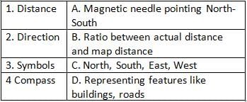
Detailed Solution for Test: Globes and Maps - 1 - Question 2
Detailed Solution for Test: Globes and Maps - 1 - Question 3
Test: Globes and Maps - 1 - Question 4
The Earth's daily rotation completes a full 360° cycle in ____________ hours.
Detailed Solution for Test: Globes and Maps - 1 - Question 4
Test: Globes and Maps - 1 - Question 5
Equinox is to equal days and nights as Solstice is to ______.
Detailed Solution for Test: Globes and Maps - 1 - Question 5
Test: Globes and Maps - 1 - Question 6
Match the following types of maps with their descriptions:
- Physical Maps A. Detailed information including roads and buildings
- Political Maps B. Natural features like mountains, rivers
- Thematic Maps C. Cities, towns, and villages with boundaries
Detailed Solution for Test: Globes and Maps - 1 - Question 6
Test: Globes and Maps - 1 - Question 7
The circle that divides day and night is called the ____________.
Detailed Solution for Test: Globes and Maps - 1 - Question 7
Test: Globes and Maps - 1 - Question 8
The maps that show a lot of details about a small area is called ____________ .
Detailed Solution for Test: Globes and Maps - 1 - Question 8
Test: Globes and Maps - 1 - Question 9
Rotation is to day-night cycle as Revolution is to ____________.
Detailed Solution for Test: Globes and Maps - 1 - Question 9
Test: Globes and Maps - 1 - Question 10
What are the benefits of using maps over globes for studying specific regions?
Detailed Solution for Test: Globes and Maps - 1 - Question 10
Information about Test: Globes and Maps - 1 Page
In this test you can find the Exam questions for Test: Globes and Maps - 1 solved & explained in the simplest way possible.
Besides giving Questions and answers for Test: Globes and Maps - 1, EduRev gives you an ample number of Online tests for practice
Download as PDF


