UGC NET Exam  >  UGC NET Tests  >  UGC NET Mock Test Series 2024  >  UGC NET Paper 2 Geography Mock Test - 6 - UGC NET MCQ

UGC NET Paper 2 Geography Mock Test - 6 - UGC NET MCQ


Test Description

30 Questions MCQ Test UGC NET Mock Test Series 2024 - UGC NET Paper 2 Geography Mock Test - 6

UGC NET Paper 2 Geography Mock Test - 6 for UGC NET 2024 is part of UGC NET Mock Test Series 2024 preparation. The UGC NET Paper 2 Geography Mock Test - 6 questions and answers have been prepared according to the UGC NET exam syllabus.The UGC NET Paper 2 Geography Mock Test - 6 MCQs are made for UGC NET 2024 Exam. Find important definitions, questions, notes, meanings, examples, exercises, MCQs and online tests for UGC NET Paper 2 Geography Mock Test - 6 below.
Solutions of UGC NET Paper 2 Geography Mock Test - 6 questions in English are available as part of our UGC NET Mock Test Series 2024 for UGC NET & UGC NET Paper 2 Geography Mock Test - 6 solutions in Hindi for UGC NET Mock Test Series 2024 course. Download more important topics, notes, lectures and mock test series for UGC NET Exam by signing up for free. Attempt UGC NET Paper 2 Geography Mock Test - 6 | 100 questions in 120 minutes | Mock test for UGC NET preparation | Free important questions MCQ to study UGC NET Mock Test Series 2024 for UGC NET Exam | Download free PDF with solutions
UGC NET Paper 2 Geography Mock Test - 6 - Question 1

Cirrus' refers to

Detailed Solution for UGC NET Paper 2 Geography Mock Test - 6 - Question 1

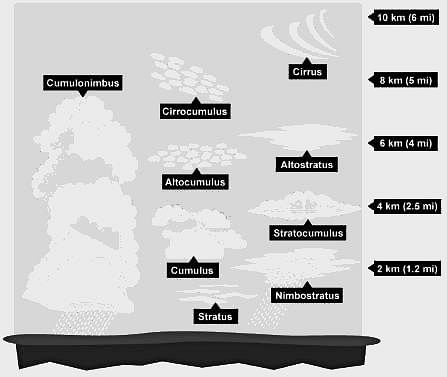
'Cirrus' refers to a high cloud.

Important Points

Cirrus Cloud:-

  • Cirrus clouds appear high in the atmosphere, above 20,000 feet (6 km).
  • Cirrus clouds are made of tiny ice crystals.
  • The atmosphere is very cold in the stratosphere where cirrus clouds occur.
  • Cirrus clouds are high-level clouds found at an altitude of 20,000 feet or higher.
  • These clouds are composed of ice crystals and are usually thin, wispy, and white.

They are sometimes called "mare's tails" because of their long, thin, and feathery appearance. Cirrus clouds usually indicate fair weather, but they can also be a sign of an approaching storm.

Additional Information

  • Cumulus clouds:-
    • These clouds form when the air cools to the dew point, the temperature at which the air can no longer hold all its water vapor.
    • These “fair weather” clouds look like cotton wool.
    • If we look at a sky filled with cumuli, we may notice they have flat bases, which all lie at the same level.
    • So, Statement 2 is correct.
  • Stratus clouds:-
    • These are composed of thin layers of clouds covering a large area of the sky.
    • This is simply mist or fog when it forms close to the ground.
    • We can easily distinguish a stratus cloud by the long horizontal layers of the cloud which have a fog-like appearance
    • So, Statement 3 is correct.
  • Nimbus Clouds:-
    • The word nimbus means a cloud that already has rain or snow falling from it.
    • These clouds are dark and seen during a thunderstorm along with thunder and lightning.
UGC NET Paper 2 Geography Mock Test - 6 - Question 2

Which one of the following is NOT a current of the Atlantic Ocean?

Detailed Solution for UGC NET Paper 2 Geography Mock Test - 6 - Question 2

The correct answer is Agulhas Current.

 Key Points

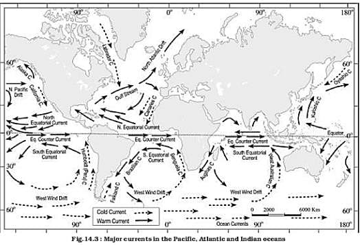
  • Agulhas current is a warm current flows south along east Coast of Africa in Southwest Indian ocean.
  • Benguela current is a cold current flows along the coast of South Africa, Namibia, and Angola. 
  • Brazilian current is a warm current flows along the east coast of Brazil, Uruguay and Argentina.
  • Canaries current is a cold current present between Fram strait and cape farewell in North Atlantic ocean.

Additional Information

  • Ocean current is a massive movement of ocean water that is caused and influenced by various forces.
  • Forces responsible for the ocean currents are wind, gravity, Coriolis force, heating by solar energy, water density and temperature of the water.
  • Mainly, ocean currents are classified into two types. they are cold currents and warm currents
    • Cold currents bring cold water into warm water areas usually found on the west coast of the continents.
    • Warm currents bring warm water into cold water areas usually found on the east coast of continents. 
1 Crore+ students have signed up on EduRev. Have you? Download the App
UGC NET Paper 2 Geography Mock Test - 6 - Question 3

Arrange the following continents in descending order of size:

South America, Africa, Antarctica, Europe, North America

Choose the correct option.

Detailed Solution for UGC NET Paper 2 Geography Mock Test - 6 - Question 3

The correct answer is Africa, North America, South America, Europe, Antarctica
Important Points

Africa:

  • Africa is the largest continent in terms of land area. It spans across 30.37 million square kilometers and is home to 54 recognized countries.
  • Some of the notable features of Africa include the Sahara Desert, the Nile River, and diverse wildlife in regions like the Serengeti and the Congo Basin.

North America:

  • North America is the second-largest continent in terms of land area.
  • It covers approximately 24.71 million square kilometers and includes countries such as the United States, Canada, Mexico, and several others.
  • Notable geographical features of North America include the Rocky Mountains, the Great Lakes, and the Grand Canyon.

South America:

  • South America is the third-largest continent, slightly smaller than North America.
  • It spans about 17.84 million square kilometers and includes countries like Brazil, Argentina, Peru, and many more.
  • South America is known for the Amazon Rainforest, the Andes Mountains, and iconic landmarks like Machu Picchu.

Antarctica:

  • Antarctica is the fourth-largest continent and the smallest among the five. It is located in the southernmost part of the Earth and is predominantly covered by ice.
  • Antarctica has a land area of about 14.0 million square kilometers, but most of it is covered by a thick ice sheet.
  • It is uninhabited permanently, except for some research stations, and serves as a unique scientific research site.

Europe:

  • Europe is the fifth-largest continent in terms of land area. It covers around 10.18 million square kilometers and includes countries like Germany, France, Italy, and others.
  • Europe is renowned for its rich history, diverse cultures, and famous landmarks such as the Eiffel Tower, the Colosseum, and the Acropolis.
UGC NET Paper 2 Geography Mock Test - 6 - Question 4

Any industry located in a rural area which produces any goods, renders any service with or without the use of power is known as ________

Detailed Solution for UGC NET Paper 2 Geography Mock Test - 6 - Question 4

Key Points

Village industry has been defined as any industry located in a rural area that produces any goods, renders any service with or without the use of power, and in which the fixed capital investment per head or artisan or worker does not exceed Rs. 50,000.

The Village and Small Industries Sector comprises of five Sub-Sectors viz.,

  1. Small Scale Industries (under the control of the Director of Industries and Commerce),
  2. Handlooms and Textiles,
  3. Khadi and Village Industries,
  4. Handicrafts Development and
  5. Sericulture

Since Any industry located in a rural area that produces any goods renders any service with or without the use of power is known as Village industry. Therefore Option 3 is the correct answer.

UGC NET Paper 2 Geography Mock Test - 6 - Question 5
Select the example of Active sensor in Remote sensing, from the following sensors.
Detailed Solution for UGC NET Paper 2 Geography Mock Test - 6 - Question 5

Concepts:

Remote sensing is the art and science of obtaining information about an object without physical contact with that object.

The passive sensor responds to physical stimuli. Light, heat, vibrations are detected from passive sensors as they occur in the environment. Examples are Electro-optical sensors, the Television cameras. Return Beam Vidicon.

Active sensors work along with transducers that create the stimuli to be detected and measured that interaction of those stimuli with the environment. Examples are Sonar or LIDAR systems, Laser scanners, etc. 

UGC NET Paper 2 Geography Mock Test - 6 - Question 6

Which among the following state of India is best known for Saffron Cultivation?

Detailed Solution for UGC NET Paper 2 Geography Mock Test - 6 - Question 6

Kashmir saffron is a high value, low volume crop and the quality of saffron is among the best in the world particularly because of its rich color and flavour. A small area in the valley, Pampore has the virtual monopoly of saffron cultivation in the country.

Thus, the correct answer is A.

UGC NET Paper 2 Geography Mock Test - 6 - Question 7
Who is known as the father of cultural geography?
Detailed Solution for UGC NET Paper 2 Geography Mock Test - 6 - Question 7

Cultural geography deals with study of cultural aspects of different ways and doings of the different countries and regions all around the world. Carl. O Sauer is known as the father of cultural geography. One of his best work is ‘Agricultural origin and dispersal’.

Thus, the Correct answer is A.

UGC NET Paper 2 Geography Mock Test - 6 - Question 8

Match the following ocean currents with which they are named :
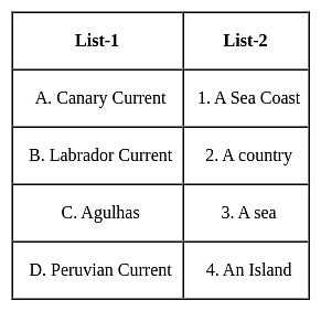

Select the correct code :

Detailed Solution for UGC NET Paper 2 Geography Mock Test - 6 - Question 8

The correct answer is Option 4.
Important Point

  • Ocean currents
    • Ocean currents are like rivers flowing in oceans.
    • They represent a regular volume of water in a definite path and direction.
    • Ocean currents are influenced by two types of forces namely :
      • Primary forces that initiate the movement of water;
      • Secondary forces that influence the currents to flow
    • The primary forces that influence the currents are
      • Heating by solar energy 
        • Heating by solar energy causes the water to expand.
        • That is why near the equator the ocean water is about 8 cm higher in level than in the middle latitudes.
        • This causes a very slight gradient and water tends to flow down the slope.
      • Wind
        • Wind blowing on the surface of the ocean pushes the water to move.
        • Friction between the wind and the water surface affects the movement of the water body in its course.
      • Gravity
        • Gravity tends to pull the water down the pile and create gradient variation.
      • Coriolis force
        • The Coriolis force intervenes and causes the water to move to the right in the northern hemisphere and to the left in the southern hemisphere.
        • These large accumulations of water and the flow around them are called Gyres.
        • These produce large circular currents in all the ocean basins.
    • Major currents in the Pacific, Atlantic, and Indian oceans

Key Points

  • Effects of Ocean Currents
    • Ocean currents have a number of direct and indirect influences on human activities.
    • West coasts of the continents in tropical and subtropical latitudes (except close to the equator) are bordered by cool waters.
      • Their average temperatures are relatively low with narrow diurnal and annual ranges.
      • There is fog, but generally, the areas are arid.
    • West coasts of the continents in the middle and higher latitudes are bordered by warm waters which cause a distinct marine climate.
      • They are characterized by cool summers and relatively mild winters with a narrow annual range of temperatures.
    • Warm currents flow parallel to the east coasts of the continents in tropical and subtropical latitudes.
      • This results in warm and rainy climates.
      • These areas lie in the western margins of the subtropical anti-cyclones.
    • The mixing of warm and cold currents helps to replenish the oxygen and favor the growth of planktons, the primary food for the fish population.
      • The best fishing grounds of the world exist mainly in these mixing zones. 
UGC NET Paper 2 Geography Mock Test - 6 - Question 9

Choose the correct statement from below:

Statement I:The concentration of the economy in the core city begins as a result of innovation. capital accumulation and industrial growth.

Statement II: The pre-industrial (agricultural) society, with localized economies and a small-scale settlement structure.

Detailed Solution for UGC NET Paper 2 Geography Mock Test - 6 - Question 9

The correct answer is Both Statement I & Statement II are true.
Key Points

Both statements are taken from Core-periphery model of economic development.

  • This model was developed in 1963 by John Friedmann.
  • It is a model of the spatial organization of human activity based upon the equal distribution of power in the economy and society.

Stage 1 (Pre-industrial)

  • The pre-industrial (agricultural) society, with localized economies and a small-scale settlement structure.
  • Each settlement is fairly isolated, activities are dispersed and mobility is low.
  • There are limited differences between spatial entities in terms of levels of economic development

 Hence ,Statement I is true.

Stage 2 (Transitional)

  • The concentration of the economy in the core city begins as a result of innovation. capital accumulation and industrial growth.
  • The specific reasons behind this concentration are often not too clear, location (better access) being a significant factor, but the fact remains that a dominant centre emerges within an urban system to become its growth pole.
  • Trade and mobility increase, but within a pattern dominated by the core even if the overall mobility remained low.

 Hence ,Statement II is true.
Additional Information
Stage 3 (Industrial

  • Through a process of economic growth and diffusion, other growth centres emerge.
  • The main reasons for deconcentration are increasing input costs (mainly labor and land) in the core area.

Stage 4 (Post-industrial)

  • The urban system becomes fully integrated and spatial inequalities are reduced significantly.
  • The distribution of economic activities creates a specialization and a division of labor linked with intense flows along high-capacity transport corridors.

UGC NET Paper 2 Geography Mock Test - 6 - Question 10

What is the significance of understanding landscape evolution according to the passage?

Detailed Solution for UGC NET Paper 2 Geography Mock Test - 6 - Question 10

Answer: Option 1) Predicting future geological hazards.

Understanding landscape evolution is crucial for various reasons, encompassing geological hazards, ecological dynamics, and human interactions with the environment.

Key Points

  • Predicting future geological hazards: By understanding how landscapes evolve over time, scientists can better predict and mitigate geological hazards such as landslides, earthquakes, and volcanic eruptions.
  • This knowledge enables proactive measures to protect lives and property. 

Additional Information 

Enhancing agricultural practices: Knowledge of landscape evolution informs agricultural practices by identifying suitable landforms for cultivation, understanding soil formation processes, and managing erosion risks. This insight contributes to sustainable agricultural development and food security.

Exploring extraterrestrial landscapes: Understanding landscape evolution on Earth provides valuable insights for interpreting landforms on other planets and celestial bodies. Comparative geomorphology helps scientists unravel the geological history of extraterrestrial landscapes and assess their potential for supporting life.

Understanding human psychology: Landscapes play a significant role in shaping human perceptions, emotions, and behavior. Understanding how landscapes evolve over time can deepen our understanding of human psychology, cultural perceptions of the environment, and the connections between people and place.

Hence,  understanding landscape evolution has multifaceted significance, ranging from mitigating geological hazards and enhancing agricultural practices to exploring extraterrestrial landscapes and understanding human psychology. This knowledge underscores the interdisciplinary nature of geomorphology and its relevance to diverse fields and societal challenges.

UGC NET Paper 2 Geography Mock Test - 6 - Question 11
The upper portion of the mantle is called .
Detailed Solution for UGC NET Paper 2 Geography Mock Test - 6 - Question 11

The correct answer is asthenosphere.

Key Points

  • Asthenosphere:
    • The asthenosphere is the denser, weaker layer beneath the lithospheric mantle.
    • It lies between about 100 kilometers (62 miles) and 410 kilometers (255 miles) beneath Earth's surface.
    • The temperature and pressure of the asthenosphere are so high that rocks soften and partly melt, becoming semi-molten.
    • The asthenosphere is generally more viscous than the lithosphere, and the lithosphere-asthenosphere boundary (LAB) is the point where geologists and rheologists, scientists who study the flow of matter mark the difference in ductility between the two layers of the upper mantle.

So, it is clear that the asthenosphere is located beneath the crust and the crustal plates are moving over this layer.

Additional Information
  • Lithosphere
  • ​The crust and the uppermost part of the mantle are called the lithosphere.
    • Its thickness ranges from 10-200 km.
    • The lithosphere is the solid, outer part of the Earth.
    • The lithosphere includes the brittle upper portion of the mantle and the crust, the outermost layers of Earth’s structure.
    • It is bounded by the atmosphere above and the asthenosphere (another part of the upper mantle) below.
  • Stratosphere:
    • It is the second major strata of air in the atmosphere.
    • It is found above the tropopause and extends up to a height of 50 km.
    • One important feature of the stratosphere is that it contains the ozone layer.
    • This layer absorbs ultra-violet radiation and shields life on the earth from an intense, harmful form of energy.
    • The air temperature in the stratosphere remains relatively constant up to an altitude of 15 miles (25 km).
  • Mesosphere:
    • The mesosphere is a layer of Earth's atmosphere.
    • The mesosphere is directly above the stratosphere and below the thermosphere.
    • It extends from about 50 to 85 km (31 to 53 miles) above our planet.
    • Temperature decreases with height throughout the mesosphere.
UGC NET Paper 2 Geography Mock Test - 6 - Question 12

Given below are two statements, one is labelled as Assertion (A) and the other as Reason (R).

Assertion (A): Rainfall occurs in the winter season in a Mediterranean climate.

Reason (R): In summer these regions remain under the influence of dry terrestrial winds.

Select the correct answer from the code given below :

Detailed Solution for UGC NET Paper 2 Geography Mock Test - 6 - Question 12

The correct answer is Both (A) and (R) are true and (R) is the correct explanation of (A)

Key Points

The Mediterranean climatic region

  • The regions are between roughly 30 and 45 degrees north and south of the equator.
  • The basic cause of this type of climate is the shifting of the wind belts.
  • The Mediterranean Sea has the greatest extent of this type of ‘winter rain climate’, and gives rise to the name Mediterranean Climate.
  • The Mediterranean climate is usually characterized by rainy winters and dry, warm to hot summers.
  • The main controlling factor over the characteristics of the dry summer subtropical climate is the alternating influence of the subtropical high in summer and Westerlies during the winter.
  • During the summers, the Mediterranean lands region experiences trade winds or easterlies, which have generally precipitated mostly by the time they reach the Mediterranean region along their path on the continents.
  • These regions remain under the influence of dry terrestrial winds.
  • Furthermore, considering they are easterlies and move towards the equator, they sweep the moisture away from the Mediterranean out to the oceans.
  • Now, during the winter period, there is a reversal of winds, due to which westerlies operate and bring the moisture from the oceans to the landmass, during which it cools, condenses and sinks to form clouds and precipitate. Thus, this is why the winters are wet in the Mediterranean regions. Hence Assertion is correct, reason also correct and its supports the assertion.
UGC NET Paper 2 Geography Mock Test - 6 - Question 13

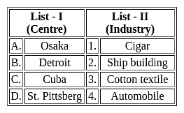
Match List - I with List - II and select the correct answer from the code given below the lists.
Detailed Solution for UGC NET Paper 2 Geography Mock Test - 6 - Question 13

The correct answer is Option 4.

Key Points

  • Osaka is an important textile centre of Japan, also known as the Manchester of Japan.
    • The textile industry developed in Osaka due to several geographical factors.
    • The textile industry in Osaka depends completely upon imported raw materials.
    • Cotton is imported from Egypt, India, China and USA. The finished product is mostly exported and has a good market.
  • Detroit is best known as the centre of the U.S. automobile industry, and the "Big Three" Auto manufacturers General Motors, Ford, and Stellantis North America are all headquartered in Metro Detroit.
  • Cuba is the largest island in the Caribbean, but only tobacco grown in the far western region of the island is best for cigars.
    • Tobacco grown there takes on the flavours of the soil and is influenced by the microclimate in that particular region.
  • St. Pittsburg is the second-largest city in Russia and is a famous centre of shipbuilding.
  • Pittsburgh is an important steel and iron city in the United States of America. The processing of iron began in Pittsburgh in mid 19th century. Hence the option 4 is correct.
  • The Pittsburgh district is the capital of the world of iron and steel.
UGC NET Paper 2 Geography Mock Test - 6 - Question 14
What would you do to prevent environmental damage?
Detailed Solution for UGC NET Paper 2 Geography Mock Test - 6 - Question 14

Concept:

Environmental degradation:

  • Environmental degradation refers to the loss of biodiversity caused by the exploitation and depletion of natural resources.
  • Degradation is the loss or depletion of something.
  • There are several types of degradation, including air, water, and land and soil degradation.

Explanation:

Waste management:

  • This Reuse, Recycle, and Reduce is associated with the practice of waste segregation and management.
  • Kitchen waste (fruit peels, vegetables, leftover food, tea leaves) forms a large percentage of the total waste at home.
  • Composting is a common method to reduce the volume of kitchen waste to ‘zero waste.’
  • Old newspapers, magazines, bottles, tins, etc products are utilised as raw materials for manufacturing other products.
  • In other words, these products are recycled.
  • There are certain items in our garbage that can be reused.
  • Reusing discarded items means that instead of dumping them and increasing the load of waste, we can reuse these items.
  • This waste management process can prevent and control environmental damage.

Thus, to prevent environmental damage we can do reuse, recycle and reduce.

Additional Information

Landfilling:

  • In the cities and towns, the collection of garbage is the responsibility of the respective municipalities.
  • The garbage then goes through a process of segregation, treatment and final disposal in the landfills.

Deforestation:

  • Deforestation means clearing off forests and using that land for others purposes.
  • Trees in the forest are cut for procuring land for cultivation, building houses and factories and making furniture or using wood as fuel.
UGC NET Paper 2 Geography Mock Test - 6 - Question 15

Consider the following statements and choose the correct answer from the options given below.

Statement I: Integration of the national economy with the world economy encourages the free flow of goods and services.

Statement II: Liberalisation aims to unlock the economic potential of the country by encouraging the private sector and multinational corporations to invest and expand

Detailed Solution for UGC NET Paper 2 Geography Mock Test - 6 - Question 15

Key Points

Globalization:

  • Globalization essentially means the integration of the national economy with the world economy.
  • It implies a free flow of information, ideas, technology, goods and services, capital, and even people across different countries and societies.
  • It increases connectivity between different markets in the form of trade, investments, and cultural exchanges.
  • The concept of globalization has been explained by the IMF (International Monetary Fund) as ‘the growing economic interdependence of countries worldwide through increasing volume and variety of cross border transactions in goods and services and of international capital flows and also through the more rapid and widespread diffusion of technology.

Hence, the statement I is correct.

Liberalization:

  • Liberalization refers to the slackening of government regulations.
  • It implies greater autonomy to the business enterprises in decision-making and removal of government interference.
  • It was believed that the market forces of demand and supply would automatically operate to bring about greater efficiency and the economy would recover.
  • This was to be done internally by introducing reforms in the real and financial sectors of the economy and externally by relaxing state control on foreign investments and trade.
  • Liberalization aims to unlock the economic potential of the country by encouraging the private sector and multinational corporations to invest and expand.

Hence, statement II is also correct.

Therefore, both the statements are correct here.

UGC NET Paper 2 Geography Mock Test - 6 - Question 16
Which of the following is not an example of spatial data?
Detailed Solution for UGC NET Paper 2 Geography Mock Test - 6 - Question 16

The correct answer is option 3.

Concept:

Spatial data:

Spatial data is any kind of data that refers to a certain geographical region or place, either directly or indirectly. Spatial data, also known as geospatial data or geographic information, can quantitatively represent a physical item in a geographic coordinate system.

Example of spatial data:

A common example of spatial data can be seen in a road map.

A road map is a two-dimensional object that contains points, lines, and polygons that can represent cities, roads, and political boundaries such as states or provinces. A road map is a visualization of geographic information.

The location of cities, roads, and political boundaries that exist on the surface of the Earth is projected onto a two-dimensional display or piece of paper, preserving the relative positions and relative distances of the rendered objects.

Hence the correct answer is times of particular events.

UGC NET Paper 2 Geography Mock Test - 6 - Question 17

Which among the following factors influence the salinity of ocean water?

1. Precipitation

2. Evaporation

3. Ocean Currents

4. Temperature

Select the correct code from the options given below:
Detailed Solution for UGC NET Paper 2 Geography Mock Test - 6 - Question 17

The correct answer is 1, 2, 3 and 4.

Key Points

Salinity:

  • All waters in nature, whether rainwater or ocean water, contain dissolved mineral salts.
  • Salinity is the term used to define the total content of dissolved salts in seawater.
  • It is calculated as the amount of salt (in gm) dissolved in 1,000 gm (1 kg) of seawater.
  • It is usually expressed as parts per thousand (‰) or ppt.
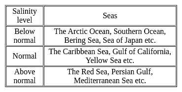
  • Salinity is an important property of seawater.
  • The main source of Salinity is the dissolution of the rocks of oceanic crust which contains salts
  • The salinity of 24.7ppt (parts per thousand) has been considered as the upper limit to demarcate ‘brackish water'.

Factors affecting ocean salinity:

  • The salinity of water in the surface layer of oceans depends mainly on evaporation and precipitation.
  • Surface salinity is greatly influenced in coastal regions by the freshwater flow from rivers, and in polar regions by the processes of freezing and thawing of ice.
  • Wind also influences the salinity of an area by transferring water to other areas.
  • The ocean currents contribute to the salinity variations.
  • Salinity, temperature and density of water are interrelated.
  • Hence, any change in the temperature or density influences the salinity of water in an area.

Evaporation:

  • It is higher at places with high rates of evaporation.

Temperature:

  • Regions with high temperatures have waters with high salinity.
  • Variations in the density or temperature affect the salinity of water in that area.

Precipitation:

  • It shares an inverse relationship with salinity.
  • Regions with higher levels of precipitation have lower levels of salinity.

Ocean Currents:

  • It affects the spatial distribution of salts in the ocean by mixing sea waters.
  • Variations in the salinity of the ocean water also contribute to the formation of ocean currents.

The Influx of Fresh Water:

  • There is a negative relationship.
  • The salinity of oceans decreases with more influx of fresh water from rivers to oceans.
  • In the Polar region, the surface salinity is influenced by the processes of freezing & melting of ice.


Thus, Precipitation, Evaporation, Ocean Currents and Temperature all influence the salinity of ocean water.

Additional Information

UGC NET Paper 2 Geography Mock Test - 6 - Question 18

Which of the following is/are the ideal conditions for temperature inversion to occur?

A. Cloudy skies

B. Calm and stable air

C. Long summer days

Select the correct answer using the codes given below:

Detailed Solution for UGC NET Paper 2 Geography Mock Test - 6 - Question 18

The correct answer is B only.

Key Points

  • The Ideal conditions for temperature inversion are:
    • Long hours, so that it is greater than the incoming radiation than the outgoing radiation.
    • Clear skies that allow radiation to escape unhindered.
    • Calm and stable air, such that, at lower speeds, there is no vertical mixing.
  • A temperature inversion is the reversal of the natural temperature activity in the troposphere, where a layer of cool air on the surface is replaced by a layer of warmer air. (The temperature normally decreases with height under normal conditions).

Additional Information

  • An inversion serves as a limit on the airflow from the layers below upwards. As a consequence, the convection produced by air heating from below is limited to levels below the inversion stage.
  • Likewise, the diffusion of dust, smoke, and other air contaminants is reduced.
  • Convective clouds do not rise high enough to create showers in regions where a pronounced low-level inversion is present.
  • Owing to the accumulation of dust and smoke particles, visibility can be significantly diminished under the inversion. Since the air at the base of inversion appears to be cold, there is sometimes fog.
UGC NET Paper 2 Geography Mock Test - 6 - Question 19
The East-West Corridor connects which of the following cities?
Detailed Solution for UGC NET Paper 2 Geography Mock Test - 6 - Question 19

The East-West corridor has been built to connect the cities of Silcher in Assam and Porbandar in Gujrat. The length of roads in the corridor is 3300 km. The corridor is a part of North-South-East-West Corridor, the largest ongoing highway project in the country.

Thus, the correct answer is D.

UGC NET Paper 2 Geography Mock Test - 6 - Question 20
Which curve is used to show the land elevations?
Detailed Solution for UGC NET Paper 2 Geography Mock Test - 6 - Question 20

A hypsometric curve is a histogram or a cumulative distribution function of elevations in a geographic area. Differences in hypsometric curves between landscapes arise because the geomorphic process that shape the landscape may be different. Thus the differences in the shape show the differences in the elevation of the landscapes on the surface of the earth.

Thus, the correct answer is B.

UGC NET Paper 2 Geography Mock Test - 6 - Question 21
Who provided a framework for analyzing the geography of political concepts?
Detailed Solution for UGC NET Paper 2 Geography Mock Test - 6 - Question 21

Richard Hartshorne, an American Geographer who specialized in economic and political geography, attempted to provide a new framework for analyzing the geography of political areas and the modern state in the 1950s as the sub discipline was becoming narrowly systematic. Hartshorne had a lot of contributions to this field such as "Political Geography in the Modern World", "The Politico-Geographic Pattern of the World".

UGC NET Paper 2 Geography Mock Test - 6 - Question 22
Which of the following statements relating to industrial regions are correct?

(a) With shift in technology, there has been a shift in the structure of industries.

(b) The globalization has caused a new international division of labour.

(c) The high tech industrial regions have very little to no place for blue collar jobs.

(d) R&D is the most important feature of traditional large scale industrial regions.

Choose the correct option from below:

Detailed Solution for UGC NET Paper 2 Geography Mock Test - 6 - Question 22

With the shift in technology, the structure of industries has changed considerably with the manufacturing low grade industries being shifted to the southern countries like Bangladesh, India. The advanced economies have kept the high-paying research intensive jobs within the same industries. The globalization and the unrestricted flow of capital has induced a new international division of labour where specialized goods and service is produced by workers of specific economies. Blue collar workers are characteristic of traditional heavy industries and the gold collar workers engaged R&D are characteristic of the hi-tech industries.

UGC NET Paper 2 Geography Mock Test - 6 - Question 23
Read the following statements and choose correct answer from the code given below:

(a) The laterite soils are used as building material.

(b) The forest soils are rich in humus.

(c) The forest soils are deficient in potash, phosphorus, and lime.

(d) Kari is a type of soil found in Kerala.

Detailed Solution for UGC NET Paper 2 Geography Mock Test - 6 - Question 23

The forest soils are rich in humus and lack potash, phosphorus, and lime. Therefore, they require a good deal of fertilizers for high yields. The laterite soils are used as building material. Kari is a type of Peaty soil in the Kottayam and Alappuzha districts of Kerala.

UGC NET Paper 2 Geography Mock Test - 6 - Question 24
“When a particular area starts developing, it attracts human as well as physical capital” these phenomena is called?
Detailed Solution for UGC NET Paper 2 Geography Mock Test - 6 - Question 24

Swedish economist Gunnar Myrdals propagated an economic development effect model namely backwash effect. Backwash effect basically means that if one particular area in a country starts growing or developing, it causes human capital as well as physical capital from other parts of the country to gravitate to this part of the country.

UGC NET Paper 2 Geography Mock Test - 6 - Question 25

Given below are two statements. One is labelled as Assertion (A) and the other is labelled as Reason (R).

Assertion (A): India is the second largest irrigated country in the world.

Reason (R): The whole country of India is fully irrigated.

Select the correct answer from options given below:

Detailed Solution for UGC NET Paper 2 Geography Mock Test - 6 - Question 25

India is the second largest irrigated country in the world. But only one-third of the total area of the country is irrigated. Majority of the country is still dependent upon the rains for water for agriculture. The Indian monsoon is highly erratic and unpredictable. Therefore, it is necessary to develop irrigation in India. Thus, (A) is true and (R) is false.

UGC NET Paper 2 Geography Mock Test - 6 - Question 26
Read the following statements and choose the correct answer from the code given below:

(a) High drainage density means that the flood risk is minimal.

(b) If the drainage density is high, the bifurcation ratio too is high.

(c) Drainage density is dependent upon climate and physical characteristics of drainage basin.

(d) Drainage density is total length of river multiplied by the total area of the drainage basin.

Code:

Detailed Solution for UGC NET Paper 2 Geography Mock Test - 6 - Question 26

The drainage density is the total length of streams and rivers is divided by the total area. High drainage density means that the flood risk is high. If the drainage density is high, the bifurcation ratio, too is high. Drainage density is dependent upon the climate and physical characteristics of drainage basin.

UGC NET Paper 2 Geography Mock Test - 6 - Question 27
According to census 2011, What is the sex ratio of Haryana? per thousand of males
Detailed Solution for UGC NET Paper 2 Geography Mock Test - 6 - Question 27

The structure of population in terms of density, age, sex, literacy and occupational structure is an important part of federalism. The sex ratio in different pats and different cultural groups varies from each other. According to census 2011, the sex ratio of Haryana is 879 females per 1000 males.

UGC NET Paper 2 Geography Mock Test - 6 - Question 28

Which one of the following is the junction point of the Eastern Ghats and Western Ghats?

Detailed Solution for UGC NET Paper 2 Geography Mock Test - 6 - Question 28

Nilgiri Hills is the junction point of the Eastern Ghats and Western Ghats. The Eastern Ghats are a discontinuous range of mountains along India's eastern coast whereas Western Ghats also known as Sahyadri is a mountain range that runs parallel to the western coast of the Indian peninsula. Eastern ghats and Western ghats meet at the Nilgiri hills in Tamilnadu.

UGC NET Paper 2 Geography Mock Test - 6 - Question 29

The demographic transition model was developed primarily to explain the:

Detailed Solution for UGC NET Paper 2 Geography Mock Test - 6 - Question 29

This question requires the examinee to demonstrate knowledge of spatial interaction, demographic cycle, cultural diffusion, patterns, relationships, and other basic geographic terms and concepts. The demographic transition model illustrates the effects of economic development on population growth by showing the developmental stages through which low birth and death rates come to replace high birth and death rates in a given area or region.

UGC NET Paper 2 Geography Mock Test - 6 - Question 30

The word ‘Map’ derived from Mappa of

Detailed Solution for UGC NET Paper 2 Geography Mock Test - 6 - Question 30

The word "map" comes from the medieval Latin Mappa mundi, wherein mappa meant napkin or cloth and mundi the world. Thus, "map" became the shortened term referring to a two-dimensional representation of the surface of the world.

View more questions
16 docs|120 tests
Information about UGC NET Paper 2 Geography Mock Test - 6 Page
In this test you can find the Exam questions for UGC NET Paper 2 Geography Mock Test - 6 solved & explained in the simplest way possible. Besides giving Questions and answers for UGC NET Paper 2 Geography Mock Test - 6, EduRev gives you an ample number of Online tests for practice

Top Courses for UGC NET

Download as PDF

Top Courses for UGC NET