Geography: CUET Mock Test - 4 - CUET MCQ
30 Questions MCQ Test - Geography: CUET Mock Test - 4

What is the temperature of the atmosphere’s warmest layer?

Given below are two statements:
Statement I: Mesosphere witnesses the declining temperature which reaches to around minus 100C, colder than the Antarctic.
Statement II: Mesosphere is the Uppermost layer.
In the light of the above statements, choose the correct answer from the options given below
Statement I: Mesosphere witnesses the declining temperature which reaches to around minus 100C, colder than the Antarctic.
Statement II: Mesosphere is the Uppermost layer.
In the light of the above statements, choose the correct answer from the options given below
Match List-I with List-II :
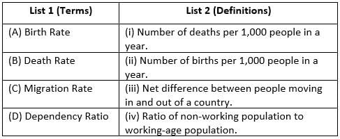
Choose the correct answer from the options given below :
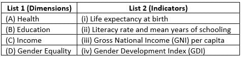
Match List-I with List-II :

Choose the correct answer from the options given below :
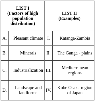
Match List-I with List-II :
Choose the correct answer from the options given below :
The rural settlements derive their life support from
Which of the following cities was developed by the British as a principal node?
In semi-clustered settlements, which group typically occupies the central part of the village?
What is the primary function of industrial towns like Jamshedpur and Bhilai?
What are the essential things that sprout from the body of geography?
What did the understanding of friction and heat help us discover?
What did the secrets of DNA and genetics enable us to conquer?
Which country has the longest road network in the world?
The longest double tracked and electrified transcontinental railway in the world is the:
Match List I with List II

Choose the correct answer from the options given below:
Match List I with List II
Choose the correct answer from the options given below:
Migration to urban areas leads to the movement of unskilled people to cities in large numbers. This gives rise to
Consider the following statements regarding the urban landscape of South America:
1. Several countries in Middle and South America have a primate city with a CBD at its center.
2. Central America and the Caribbean are slightly less urbanized than South America.
3. Sprawling slums are a common sight in the megacities and in Brazil they are called favelas.
Which of the above statements is/are incorrect?Which of the following natural condition/conditions is/are suitable for selection of an ideal site for human settlement
(A) Favorable climate
(B) Availability of water
(C) Suitable land
(D) Infertile soil
Identify the type of urban settlement with the features described below:
1. It is a leading town outstripping its local or regional rivals.
2. Has a greater number of economic functions with transport terminals, regional admin offices and major financial institutions.
3. It is the physical form of the most complex type of associatie life.
Select the correct answer from the options given below:Consider these statements and choose the correct option:
A) Primary activities includes extraction and production of natural resources.
B) Banking, transport and advertising are examples of secondary activities
C) Tertiary activities are concerned with processing of natural resources.
There are two statements, one labelled as Assertion (A) and other labelled as Reason (R):
Assertion (A): Tertiary sector includes those activities that help in the development of primary and secondary sectors.
Reason (R): Dry cleaners, barbers, teachers and doctors are included in the service sector.
Choose the correct option:
In which Five-Year Plan was Drought Prone Areas Programme initiated?
Consider the following statements and mark the correct option.
Statement I: In the Eighth Five-Year Plan, special area programmes were designed.
Statement II: Hill Area Development Programmes were initiated during the Ninth Five-Year Plan.
Important Questions for Geography: CUET Mock Test - 4
Geography: CUET Mock Test - 4 MCQs with Answers
Online Tests for Geography: CUET Mock Test - 4
|
© EduRev
|
Education Revolution
|


|


within 7 days!