Software Development Exam  >  Software Development Tests  >  HTET: Haryana G.K and Awareness (Geography) - Software Development MCQ

HTET: Haryana G.K and Awareness (Geography) - Software Development MCQ


Test Description

10 Questions MCQ Test - HTET: Haryana G.K and Awareness (Geography)

HTET: Haryana G.K and Awareness (Geography) for Software Development 2025 is part of Software Development preparation. The HTET: Haryana G.K and Awareness (Geography) questions and answers have been prepared according to the Software Development exam syllabus.The HTET: Haryana G.K and Awareness (Geography) MCQs are made for Software Development 2025 Exam. Find important definitions, questions, notes, meanings, examples, exercises, MCQs and online tests for HTET: Haryana G.K and Awareness (Geography) below.
Solutions of HTET: Haryana G.K and Awareness (Geography) questions in English are available as part of our course for Software Development & HTET: Haryana G.K and Awareness (Geography) solutions in Hindi for Software Development course. Download more important topics, notes, lectures and mock test series for Software Development Exam by signing up for free. Attempt HTET: Haryana G.K and Awareness (Geography) | 10 questions in 5 minutes | Mock test for Software Development preparation | Free important questions MCQ to study for Software Development Exam | Download free PDF with solutions
HTET: Haryana G.K and Awareness (Geography) - Question 1

Which among these following ranges lies in North-East Haryana?

Detailed Solution for HTET: Haryana G.K and Awareness (Geography) - Question 1

The correct answer is Shivalik Range.

Key Points

  • Haryana is a landlocked state located in northern India.
  • Haryana state consists of nearly 1.4% of the total geographical area of the country.
  • Haryana mainly has four geographical features:
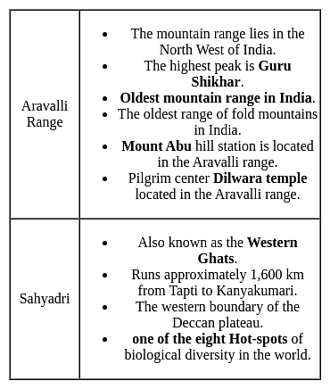
    1. The Aravali hills located in the south.
    2. Shivalik Range lies in North-East.
    3. The southwest part consists of the Bagar tract semi-desert dry sandy plain.
    4. The Yamuna-Ghaggar plain forms the largest part of the state.
  • The major rivers like Ghaggar, Tangri are originating from Shivalik Range.
  • The Karoh Peak in Shivalik Hills range of greater Himalayas is the highest point in the state of Haryana.
HTET: Haryana G.K and Awareness (Geography) - Question 2

The heavy soil found in Thanesar district of Haryana is known as

Detailed Solution for HTET: Haryana G.K and Awareness (Geography) - Question 2

The correct answer is None of these.

Key Points

  • Heavy and Very Heavy Soils in Haryana
    • This soil is found on the banks of rain-fed rivers of the state.
    • This soil has a predominance of clayey silk.
    • This soil becomes sticky in the rainy season and hardens in the dry season.
    • In the Ghaggar area of Thanesar and Fatehabad, hard clay is found which is known as Solar and ferruginous clay is found in Jagadhri which is known as Dakar.
    • The productivity of this soil can be increased by various organic and chemical fertilisers.
    • In this soil, rice, wheat, gram and barley can be grown.

Additional Information

  • Thanesar city or old Kurukshetra
    • This city is a historic town and an important Hindu pilgrimage centre in the state of Haryana in northern India.
    • It is located in the Kurukshetra district, approximately 160 km northwest of Delhi.
    • Thanesar city means the old name of Kurukshetra city.
HTET: Haryana G.K and Awareness (Geography) - Question 3

Limestone and Dolomite is mainly found in which districts of Haryana?

Detailed Solution for HTET: Haryana G.K and Awareness (Geography) - Question 3

The correct answer is Both (1) and (2).

Key Points

  • Limestone and Dolomite are mainly confined to the Mahendragarh and Ambala districts of Haryana.
  • Limestone is mainly composed of Calcium Carbonate. It is mainly used in the industry for the manufacturing of lime and cement chemicals, fertilizers and as a flux in iron and steel, ferroalloy, and other metallurgical industries.
  • Limestone is also found in the Bhiwani, Panchkula districts of Haryana.
  • Haryana state is the principal holder of the country's resources of tin (64%), quartz-silica sand (52%), and quartzite (49%).
  • When the amount of magnesium is reached at a certain level in the limestone, it is converted into a different carbonate known as dolomite. It is also useful for various industrial processes and mainly for ornamental processes as well.
HTET: Haryana G.K and Awareness (Geography) - Question 4
The river, which makes border between Haryana and Uttar Pradesh:
Detailed Solution for HTET: Haryana G.K and Awareness (Geography) - Question 4

The correct answer is the Yamuna.

Important Points

  • The Yamuna river makes the border between Haryana and Uttar Pradesh.
  • The Yamuna river also defines the borders of Haryana, Delhi, and Uttar Pradesh and between Uttrakhand and Himachal Pradesh.
  • The Yamuna river originates from the Yamunotri glacier in Uttrakhand. The ricer travels for 1,376 kilometers and merges with the Ganga at Triveni Sangam, Prayagraj.
  •  Hathni Kund Barrage is the place where Yamuna water gets divided into two large canals: Eastern Yamuna Canal towards Uttar Pradesh and Western Yamuna Canal towards Haryana.

Additional Information

  •  The Markanda river in Himachal Pradesh and Harayana is a tributary of the Ghaggar river. Aruna was the ancient name of the Markanda river.
HTET: Haryana G.K and Awareness (Geography) - Question 5
Basai Wetland is in which district of Haryana?
Detailed Solution for HTET: Haryana G.K and Awareness (Geography) - Question 5

The correct answer is Gurugram.

Key Points

  • Basai wetland, located in Basai village in Gurgaon Tehsil in Gurgaon district in Haryana.
  • It is a flora and fauna-rich water body.
  • It is recognized as one of India's Important Bird and Biodiversity Areas.
  • Basai wetland is recognized globally as an Important Bird Area (IBA) by BirdLife International housing 20,000 birds of over 280 species including migratory birds and endangered birds.
  • It has not yet been declared a protected wetland by the Government of Haryana.
  • Basai wetland lies in one of the paleochannels of the Sahibi River, a tributary of Yamuna.

Additional Information

  • Haryana has a total geographical area of 44.212 km2
  • Haryana is bounded by Punjab and Himachal Pradesh to the North and by Rajasthan to the west and south.
  • River Yamuna defines its eastern border with Uttarakhand and Uttar Pradesh.
  • The Aravalli hills region of Haryana is the driest place of the state as per rainfall distribution. 
  • Haryana is a landlocked state in the northwest of India and was carved out of the Indian State of Punjab on 1st November 1966.
  • The soil in Haryana is formed almost entirely of alluvium.
HTET: Haryana G.K and Awareness (Geography) - Question 6
The district of Haryana was carved out from Karnal district on 1 November 1989. On 24 July 1991, it was again merged with Karnal district. On 1 January 1992, it again became a separate district. Which is the district?
Detailed Solution for HTET: Haryana G.K and Awareness (Geography) - Question 6
  • Panipat district was carved out of Karnal district on 1 November 1989.
  • On 24 July 1991, it was again merged with Karnal district.
  • On 1 January 1992, it again became a separate district.
  • Panipat:-
    • It is a historic city in Haryana, India.
    • It is 90 km north of Delhi and 169 km south of Chandigarh on National Highway.
    • The three battles fought near the city in 1526 (Babur v/s Ibrahim Lodi), 1556 (Hemuv/s Akbar) and 1761 (Maratha v/s Durrani Empire).
    • The city is famous in India by the name of “City of Weavers” and “Textile City”.
HTET: Haryana G.K and Awareness (Geography) - Question 7
Morni hill is located in which of the following ranges?
Detailed Solution for HTET: Haryana G.K and Awareness (Geography) - Question 7

The correct answer is Shivalik range.

  • It is situated in the lower reaches of the Shivalik range.
  • It is at an elevation of 3,600 feet above sea level, it has a fascinating range of flora and fauna. 
  • Different Haryana Hills and Ranges
    • Shivalik Range - Found in North Haryana
    • Aravalli Range - Found in Southwest, this range passes through the states of Haryana, Rajasthan, Gujarat, Delhi.
    • Morni Hills - Panchkula district (It is only Hill station of Haryana)
    • Dhosi Hills - Mahendragarh district (It is an extinct volcano)
HTET: Haryana G.K and Awareness (Geography) - Question 8
As per 2011 population census, what is the literacy rate of Haryana?
Detailed Solution for HTET: Haryana G.K and Awareness (Geography) - Question 8

The correct answer is 75.55​.

  • The literacy rate in Haryana is 75.55 per cent as per the population census of 2011.

Key Points

  • The male literacy rate of the state is 85.38 per cent and the female literacy rate is 66.67 per cent.
  • The literacy rate of Haryana was 67.91 per cent in 2001 and the male and female literacy rate was 78.49 and 55.73 per cent respectively.
  • The highest literacy rate in Haryana is in Gurgaon city.
HTET: Haryana G.K and Awareness (Geography) - Question 9
Which among the following district of Haryana do not touches the boundary of Charkhi Dadri district of Haryana?
Detailed Solution for HTET: Haryana G.K and Awareness (Geography) - Question 9

The correct answer is Gurgaon.

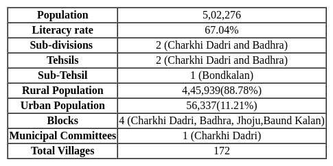
  • The Charkhi Dadri district touches the boundary of Jhajjar, Rewari, Mahendragarh, Rohtak, Bhiwani.

  • District Charkhi Dadri is located between 28°35’31.42″ North Latitude and 76°15’55.05″ East Longitude respectively.
  • The Charkhi Dadri has one municipal committee i.e Charkhi Dadri.
  • Charkhi Dadri District is one of the 22 districts of Haryana state in northern India.
  • The Government of Haryana state officially notified Charkhi Dadri as 22nd district of Haryana on 01 December 2016.
  • District Charkhi Dadri has located 112.6 km of India capital New Delhi and 295 km of Haryana capital Chandigarh.
  • Charkhi Dadri was carved out from the Bhiwani district of Haryana.
HTET: Haryana G.K and Awareness (Geography) - Question 10
Haryana does NOT comes in which of the following seismic zone?
Detailed Solution for HTET: Haryana G.K and Awareness (Geography) - Question 10

The correct answer is Seismic Zone V.

Key Points

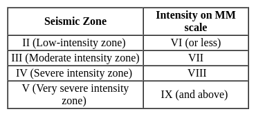
  • Haryana falls in the Seismic Zones II, III & IV creating low to moderate damage risk from Earthquakes.
  • But the state comes under the “Cyclonic Zone” creating very high damage risk.
  • There are four seismic zones in India which have different risk of an earthquake.
  • The Modified Mercalli (MM) intensity, which measures the impact of the earthquakes on the surface of the earth.
  • It measures the intensity while the Ritcher scale measures the magnitude of earthquake.
  • The range of intensity scale is from 1-12.

Notes:

  • Ritcher scale:
    • The earthquake events are scaled either according to the magnitude or intensity of it.
    • The magnitude scale is known as the Richter scale.
    • The magnitude in this relates to the energy released during the earthquake.
    • Its range is 0-10.
Information about HTET: Haryana G.K and Awareness (Geography) Page
In this test you can find the Exam questions for HTET: Haryana G.K and Awareness (Geography) solved & explained in the simplest way possible. Besides giving Questions and answers for HTET: Haryana G.K and Awareness (Geography), EduRev gives you an ample number of Online tests for practice
Download as PDF