MAHA TET Exam  >  MAHA TET Tests  >  MH SET Mock Test Series 2024  >  MH SET Paper 2 Mock Test - 3 (Geography) - MAHA TET MCQ

MH SET Paper 2 Mock Test - 3 (Geography) - MAHA TET MCQ


Test Description

30 Questions MCQ Test MH SET Mock Test Series 2024 - MH SET Paper 2 Mock Test - 3 (Geography)

MH SET Paper 2 Mock Test - 3 (Geography) for MAHA TET 2024 is part of MH SET Mock Test Series 2024 preparation. The MH SET Paper 2 Mock Test - 3 (Geography) questions and answers have been prepared according to the MAHA TET exam syllabus.The MH SET Paper 2 Mock Test - 3 (Geography) MCQs are made for MAHA TET 2024 Exam. Find important definitions, questions, notes, meanings, examples, exercises, MCQs and online tests for MH SET Paper 2 Mock Test - 3 (Geography) below.
Solutions of MH SET Paper 2 Mock Test - 3 (Geography) questions in English are available as part of our MH SET Mock Test Series 2024 for MAHA TET & MH SET Paper 2 Mock Test - 3 (Geography) solutions in Hindi for MH SET Mock Test Series 2024 course. Download more important topics, notes, lectures and mock test series for MAHA TET Exam by signing up for free. Attempt MH SET Paper 2 Mock Test - 3 (Geography) | 100 questions in 120 minutes | Mock test for MAHA TET preparation | Free important questions MCQ to study MH SET Mock Test Series 2024 for MAHA TET Exam | Download free PDF with solutions
MH SET Paper 2 Mock Test - 3 (Geography) - Question 1

Which factor of globalization has largest share in spreading out production of services recent days?

Detailed Solution for MH SET Paper 2 Mock Test - 3 (Geography) - Question 1

Information and communication technology is the factor of globalization has largest share in spreading out production of services recent days.

Important Points

  • Rapid improvement in technology has been one major factor that has stimulated the globalisation process.
  • Even more remarkable have been the developments in information and communication technology.
  • In recent times, technology in the areas of telecommunications, computers, Internet has been changing rapidly.
  • Telecommunication facilities (telegraph, telephone including mobile phones, fax) are used to contact one another around the world, to access information instantly, and to communicate from remote areas.

Information and communication technology (or IT in short) has played a major role in spreading out production of services across countries.

MH SET Paper 2 Mock Test - 3 (Geography) - Question 2

Which of the following theories mention that the political and economic relationships between countries and regions of the world control and limit the economic development possibilities of the poor areas?

Detailed Solution for MH SET Paper 2 Mock Test - 3 (Geography) - Question 2

Dependency theory, another major body of the development theory, which holds that the political and economic relationships between countries and regions of the world control and limit the economic development possibilities of the poorer areas. Some theorists have stated, the colonialism created political and economic structures that caused the colonies to become dependent on the colonial powers. Many poorer countries tie their currency to a wealthy country's currency or by adopting the wealthy country's currency as their own, creating a important link between the poor and the wealthy country's economy.

1 Crore+ students have signed up on EduRev. Have you? Download the App
MH SET Paper 2 Mock Test - 3 (Geography) - Question 3

Which of the following statement best characterizes New International Division of Labour?

Detailed Solution for MH SET Paper 2 Mock Test - 3 (Geography) - Question 3

The New International Division of Labour (NIDL), is the consequence of globalization and is referred to as the characteristic feature of the Post-Fordist era. The high paying jobs are still concentrated in the core economies and the low-paying jobs within the same industry is concentrated in the third world countries. Example, the shoemaking will be done in cottage industries of Bangladesh for large MNCs whose headquarter and the R&D wing is situated in United States.

MH SET Paper 2 Mock Test - 3 (Geography) - Question 4

What are true in relation to jet stream?

(i) Jet stream blow across Asian Continent at latitudes North of Himalayas parallel to Tibetan highlands.

(ii) Tibetan highland divides jet stream into North and South branches.

(iii) The northern branch of jet stream plays important role in winter weather in India.

Detailed Solution for MH SET Paper 2 Mock Test - 3 (Geography) - Question 4

The correct answer is (i) and (ii) 

Key Points  Jet stream

Higher up in the atmosphere, a different pattern of air circulation is observed during the winter months:

  • All of Western and Central Asia remains under the influence of westerly winds along the altitude of 9-13 km from west to east. These winds blow across the Asian continent at latitudes north of the Himalayas roughly parallel to the Tibetan highlands. These are known as the sub-tropical/tropical westerly jet stream. Hence, statement 1 is correct.
  • Tibetan highlands act as a barrier in the path of these jet streams. As a result, jet streams get bifurcated.
    • One of its branches blows to the north of the Tibetan highlands, while the southern branch blows in an eastward direction, south of the Himalayas, later recombining into a single stream over China.Hence,statement 2 is correct.
  • It is believed that this southern branch of the jet stream exercises an important influence on the winter weather in India.Hence,statement 3 is incorrect.
  • The mean position of this jetstream is about 25°N.

MH SET Paper 2 Mock Test - 3 (Geography) - Question 5

Which among the following state of India is best known for Saffron Cultivation?

Detailed Solution for MH SET Paper 2 Mock Test - 3 (Geography) - Question 5

Kashmir saffron is a high value, low volume crop and the quality of saffron is among the best in the world particularly because of its rich color and flavour. A small area in the valley, Pampore has the virtual monopoly of saffron cultivation in the country.

Thus, the correct answer is A.

MH SET Paper 2 Mock Test - 3 (Geography) - Question 6
An earthquake is considered as major earthquake when its magnitude ranges
Detailed Solution for MH SET Paper 2 Mock Test - 3 (Geography) - Question 6

Key Points

Earthquake: An earthquake is a sudden shaking or trembling of the earth which lasts for a very short time. It is caused by a disturbance deep inside the earth’s crust.

  • An earthquake is measured with a machine called a seismograph. The power of an earthquake is expressed in terms of magnitude on a scale called the Richter scale.
  • An earthquake of 2.0 or less can be felt only a little.
  • An earthquake over 5.0 can cause damage from things falling.
  • A 6.0 or higher magnitude is considered very strong and 7.0 is classified as a major earthquake.
  • Really destructive earthquakes have magnitudes higher than 7 on the Richter scale.

Hence, an earthquake is considered a major earthquake when its magnitude ranges 6-7.

Additional Information

  • Richter scale is not linear. This means that an earthquake of magnitude 6 does not have one and a half times the destructive energy of an earthquake of magnitude 4.
  • In fact, an increase of 2 in magnitude means 1000 times more destructive energy. Therefore, an earthquake of magnitude 6 has a thousand times more destructive energy than an earthquake of magnitude 4.
MH SET Paper 2 Mock Test - 3 (Geography) - Question 7

Which among the following factors influence the salinity of ocean water?

1. Precipitation

2. Evaporation

3. Ocean Currents

4. Temperature

Select the correct code from the options given below:
Detailed Solution for MH SET Paper 2 Mock Test - 3 (Geography) - Question 7

The correct answer is 1, 2, 3 and 4.

Key Points

Salinity:

  • All waters in nature, whether rainwater or ocean water, contain dissolved mineral salts.
  • Salinity is the term used to define the total content of dissolved salts in seawater.
  • It is calculated as the amount of salt (in gm) dissolved in 1,000 gm (1 kg) of seawater.
  • It is usually expressed as parts per thousand (‰) or ppt.
  • Salinity is an important property of seawater.
  • The main source of Salinity is the dissolution of the rocks of oceanic crust which contains salts
  • The salinity of 24.7ppt (parts per thousand) has been considered as the upper limit to demarcate ‘brackish water'.

Factors affecting ocean salinity:

  • The salinity of water in the surface layer of oceans depends mainly on evaporation and precipitation.
  • Surface salinity is greatly influenced in coastal regions by the freshwater flow from rivers, and in polar regions by the processes of freezing and thawing of ice.
  • Wind also influences the salinity of an area by transferring water to other areas.
  • The ocean currents contribute to the salinity variations.
  • Salinity, temperature and density of water are interrelated.
  • Hence, any change in the temperature or density influences the salinity of water in an area.

Evaporation:

  • It is higher at places with high rates of evaporation.

Temperature:

  • Regions with high temperatures have waters with high salinity.
  • Variations in the density or temperature affect the salinity of water in that area.

Precipitation:

  • It shares an inverse relationship with salinity.
  • Regions with higher levels of precipitation have lower levels of salinity.

Ocean Currents:

  • It affects the spatial distribution of salts in the ocean by mixing sea waters.
  • Variations in the salinity of the ocean water also contribute to the formation of ocean currents.

The Influx of Fresh Water:

  • There is a negative relationship.
  • The salinity of oceans decreases with more influx of fresh water from rivers to oceans.
  • In the Polar region, the surface salinity is influenced by the processes of freezing & melting of ice.


Thus, Precipitation, Evaporation, Ocean Currents and Temperature all influence the salinity of ocean water.

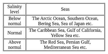
Additional Information

MH SET Paper 2 Mock Test - 3 (Geography) - Question 8
Which of the following seas separate Europe from Africa?
Detailed Solution for MH SET Paper 2 Mock Test - 3 (Geography) - Question 8

Explanation:

The correct answer is the Mediterranean Sea.

Key Points

Strait of Gibraltar:

  • It separates Europe and Africa.
  • It connects the Mediterranean Sea with the Atlantic Ocean.
  • It is an important gap, averaging 1200 feet in depth in the arc formed by the Atlas Mountains of North Africa and the high plateau of Spain.
  • The Winds in the strait tend to be either easterly or westerly.
  • Shallow cold-air masses invading the western Mediterranean from the north, often stream through as a low level.
  • The high-speed easterly wind is known locally as a Levanter.
  • The strait of Gibraltar is a narrow strait that connects the Atlantic Ocean to the Mediterranean Sea and separates Gibraltar and Spain in Europe from Morocco in Africa.

MH SET Paper 2 Mock Test - 3 (Geography) - Question 9

At what plate boundary setting is the ocean floor deepest?

Detailed Solution for MH SET Paper 2 Mock Test - 3 (Geography) - Question 9

Answer: Option 2) Subduction.

The Earth's lithosphere is divided into tectonic plates that interact with one another at plate boundaries, influencing the topography of the ocean floor. The subsequent question delves into the characteristics of different plate boundary settings and seeks to identify the setting where the ocean floor is the deepest.

Key Points

  • The ocean floor is deepest at subduction zones.
  • Subduction zones occur at convergent plate boundaries, where one tectonic plate is forced beneath another.
  • This process results in the formation of deep ocean trenches, such as the Mariana Trench in the western Pacific, which is known as the deepest point on Earth's ocean floor.
  • The subduction of oceanic plates beneath continental plates or another oceanic plate creates a trench-like depression.

 Additional Information

  • Divergent: At divergent plate boundaries, tectonic plates move away from each other, creating mid-ocean ridges. While these ridges can be elevated, they are not associated with the deepest parts of the ocean floor.
  • Continent - Continent Collision: Continent-continent collisions result in the formation of large mountain ranges, such as the Himalayas. While this setting can lead to significant topographical features, it does not create the deepest parts of the ocean floor.
  • Transform: Transform plate boundaries involve plates sliding past each other horizontally. They are associated with features like strike-slip faults but do not typically result in the creation of deep ocean trenches.

Hence, the ocean floor is deepest at subduction zones.

MH SET Paper 2 Mock Test - 3 (Geography) - Question 10

What is the depth range of shallow seawater over the continental shelf?

Detailed Solution for MH SET Paper 2 Mock Test - 3 (Geography) - Question 10

Answer: Option 3)  120 to 370 meters.

The Earth's geographical features are diverse, ranging from towering mountain ranges to vast oceanic expanses. One intriguing aspect is the continental shelf, a shallow submerged extension of continents. Within this unique realm, the depth of seawater varies, playing a crucial role in marine ecosystems. The forthcoming question explores the specific depth range of shallow seawater over the continental shelf.

Important Points 

  • The depth range of shallow seawater over the continental shelf is between 120 to 370 meters.
  • This range was emphasized in the passage, highlighting the relatively shallow nature of this region compared to the deeper waters of the open ocean.
  • The shallowness of this area is of paramount significance, as it allows sunlight to penetrate the water column, fostering the growth of microscopic plants and animals known as plankton.
  • This, in turn, makes the continental shelf a rich source of food for various marine organisms. 

Hence, 120 to 370 meters (Option c), is a critical parameter defining the characteristics and ecological importance of this geographical feature.

MH SET Paper 2 Mock Test - 3 (Geography) - Question 11
Eskimos" are associated with which geographical region?
Detailed Solution for MH SET Paper 2 Mock Test - 3 (Geography) - Question 11

The correct answer is Polar Region.

Key Points

  • Eskimos are the indigenous circumpolar people who have traditionally inhabited the northern circumpolar region from eastern Siberia (Russia) to Alaska (United States), Canada, and Greenland (Denmark).
  • Polar Region
    • The part of the Earth's surface forms a cap over a pole; characterized by a frigid climate.
    • There are two main polar regions in the world, which are the Arctic and the Antarctic.
    • The Arctic Circle and Arctic Tundra are found at the North Pole, and it covers nearly 5 million square miles of the
    • top of the Northern Hemisphere.

Additional Information

  • Arid Region
    • An arid region, also known as a desert, is defined by a severe lack of available water, to the extent of hindering or preventing the growth and development of plant and animal life.
    • This harsh environment is typically characterized by extremely low rainfall, high temperatures, and high evaporation rates.
    • Due to the scarcity of water, the biodiversity in arid regions is lower compared to other ecosystems.
  • Savanna Grassland
    • Savanna grasslands in Brazil are called Campos.
    • These grasslands lie between 24°S and 35°S, which includes Uruguay and parts of Paraguay, Brazil, and Argentina.
    • These are rich in plant species and are more diverse than forest ecosystems.
    • The climate here is subtropical humid and the rainfall is distributed regularly all over the year.
    • A grassland is an area that mostly comprises grasses.
  • Tropical Rainforest Region
    • The tropical rainforest is a forest with tall trees in a region of year-round high temperatures where an average of 50 to 260 inches of rain falls yearly.
    • The tropical rainforests are confined to areas of heavy rainfall.
    • Such areas are in the Western Ghats, upper parts of Assam, Tamil Nadu coast, and the island groups of Lakshadweep and Andaman & Nicobar.
    • Areas that receive more than 200 cm of rainfall and have a short dry season are the best area for the tropical rainforest.
MH SET Paper 2 Mock Test - 3 (Geography) - Question 12
Which of the following question is related to the causal relationships between features?
Detailed Solution for MH SET Paper 2 Mock Test - 3 (Geography) - Question 12

The correct answer is Why.

Key Points

  • A causal relationship exists when one variable in a data set has a direct influence on another variable. Thus, one event triggers the occurrence of another event.
  • A causal relationship is also referred to as cause and effect that realization to why.
  • Causal relationships in real-world settings are complex, and statistical interactions of variables are assumed to be pervasive (e.g., Brunswick 1955, Cronbach 1982). This means that the strength of a causal relationship is assumed to vary with the population, setting, or time represented within any given study, and with the researcher's choices about treatments and measurement of outcomes.
  • Without a sensitive assessment of such interactions, true effects can be obscured or causal claims can be overgeneralized to a wider range of people, settings, times, treatments, or outcome constructs than is warranted. Unfortunately, the number of possible interactions is endless, posing problems to the analyst that are insuperable, at least in theory (Cook 1993).
  • The practical task is to assess the most plausible interactions within a given research area. Interactions occur often between treatment, populations, measures, and context, posing the most plausible threats to external validity (Campbell and Stanley 1966, Cook and Campbell 1979). Because external validity specifies the conditions under which an internally valid relationship can be reproduced, threats to external validity necessarily invoke internal validity.
  • A causal generalization, e.g., that smoking causes lung cancer, is not about a particular smoker but states a special relationship exists between the property of smoking and the property of getting lung cancer.
  • To establish causality you need to show three things–that X came before Y, that the observed relationship between X and Y didn't happen by chance alone, and that there is nothing else that accounts for the X -> Y relationship.
MH SET Paper 2 Mock Test - 3 (Geography) - Question 13

Given below are two statements. One is labelled as Assertion (A) and the other is labelled as Reason (R).

Assertion (A): La Nina is the phenomenon that leads to droughts in India.

Reason (R): The Humboldt Current decreases temperature of water by 5-60 C

Select the correct answer from options given below:

Detailed Solution for MH SET Paper 2 Mock Test - 3 (Geography) - Question 13

La Nina means the little girl. The Humboldt Current in the South Pacific Ocean is a cold current that brings ice bergs from Antarctica and the temperature of the water decreases by 5-60 C. This leads to the Indian monsoon being accelerated and causes floods and landslides in India. Thus, (A) is false and (R) is true.

MH SET Paper 2 Mock Test - 3 (Geography) - Question 14

Use the information below to answer the question that follows.

• fluctuating water table

• large herbivores, carnivores, and scavengers

• tall, coarse grass

• low-growing, drought-resistant tree species

The information presented best describes major features of which of the following grassland biomes?

Detailed Solution for MH SET Paper 2 Mock Test - 3 (Geography) - Question 14

This question requires the examinee to demonstrate knowledge of the distribution and characteristics of major global and regional ecosystems. Major tropical savanna grasslands can be found in northern and eastern India, northern Australia, south central Africa, western Central America, and the Llanos region of Venezuela. Their major features include fluctuating water tables, leached soils, large herbivores, carnivores, and scavengers, tall, coarse grass, and scattered low-growing, drought-resistant trees, scrub, and thorn bushes.

MH SET Paper 2 Mock Test - 3 (Geography) - Question 15
As per Census 2011, the rural and urban sex-ratio respectively in India is
Detailed Solution for MH SET Paper 2 Mock Test - 3 (Geography) - Question 15

The Correct Answer is 949, 929.

Key Points

  • As per Census 2011, India's population was 121.06 Cr and females constituted 48.5% of it. In 2011, the sex ratio (number of females per 1000 males) at all India levels was 943 and the same for rural and urban areas are 949 and 929 respectively. 
  • Major points of the 2011 census are-
    • State with the highest population density - Bihar
    • State with lowest population density - Arunanchal Pradesh
    • State with the highest sex ratio - Kerala
    • State with the lowest sex ratio - Haryana
    • State with the highest literacy rate - Kerala
    • State with the lowest literacy rate - Bihar

Additional Information

  • Census 2011
    • It was the 15th Census of India and the 7th Census of Independent India.
    • Census 2011 Commissioner: C. Chandramouli
    • Slogan: Our Census, Our Future
    • No. of districts: 640
    • No. of towns: 7933
    • No.of villages: 640930
    • The total population of India as per the Census 2011 is 1210.19 million (68.84% urban and 31.16% rural) of which 623.7 million were males and 586.46 million were females.
    • Sex Ratio: 940 Females/1000
    • Child Sex Ratio: 919( Rural- 923, Urban- 905)
    • The density of Population: 382 Persons/Km2
    • Literacy Rate: 74.04% of the total population( males: 82.14% and females: 65.46%)
    • Population Growth Rate during the decade: 17.7% 
MH SET Paper 2 Mock Test - 3 (Geography) - Question 16

Consider the following statements about Equator and choose the correct option:

(A) The equator is a real line running on the globe, which divides it into two equal parts.

(B) The equator is the longest latitude.

(C) The equator represents the 180° latitude.

Detailed Solution for MH SET Paper 2 Mock Test - 3 (Geography) - Question 16

The correct option is: Only (B)are true.
Important Points

(A)The equator is a real line running on the globe, which divides it into two equal parts.

  • The statement is incorrect.
  • The equator is an imaginary line running horizontally around the Earth, dividing it into the Northern Hemisphere and the Southern Hemisphere.
  • It is not a real physical line on the Earth's surface.

(B) The equator is the longest latitude.

  • The statement is true.
  • The equator is the longest latitude line. It is the largest circle of latitude, measuring approximately 40,075 kilometers or 24,901 miles in length.

(C) The equator represents the 180° latitude.

  • The statement is incorrect.
  • The Equator represents 0° latitude.
  • It is the imaginary line that equally divides the Northern and Southern Hemispheres.
  • Latitude lines are measured from the Equator, with values increasing up to 90° north at the North Pole and 90° south at the South Pole.
  • The 180° line you may be thinking of is the 180° longitude line, which is part of the system used to divide the Eastern and Western Hemispheres.
MH SET Paper 2 Mock Test - 3 (Geography) - Question 17
The height of Tsunami’s wave depends upon _______.
Detailed Solution for MH SET Paper 2 Mock Test - 3 (Geography) - Question 17

Explanation:

Tsunamis:

(i) Tsunamis, also known as seismic sea waves (mistakenly called “tidal waves”), are a series of enormous waves created by an underwater disturbance such as an earthquake, landslide, volcanic eruption, or meteorite. A tsunami can move hundreds of miles per hour in the open ocean and smash into land with waves as high as 100 feet or more.

(ii) From the area where the tsunami originates, waves travel outward in all directions. Once the wave approaches the shore, it builds in height. The topography of the coastline and the ocean floor will influence the size of the wave. There may be more than one wave and the succeeding one may be larger than the one before. That is why a small tsunami at one beach can be a giant wave a few miles away.

Additional InformationThe physics of a Tsunami:

(i) Tsunamis can have wavelengths ranging from 10 to 500 km and wave periods of up to an hour. As a result of their long wavelengths, tsunamis act as shallow-water waves.

(ii) A wave becomes a shallow-water wave when the wavelength is very large compared to the water depth. Shallow-water waves move at a speed, c, that is dependent upon the water depth and is given by the formula

c = √gH

where g is the acceleration due to gravity (= 9.8 m/s2) and H is the depth of water.

(ii) In the deep ocean, the typical water depth is around 4000 m, so a tsunami will therefore travel at around 200 m/s or more than 700 km/h.

MH SET Paper 2 Mock Test - 3 (Geography) - Question 18
Which one of the following statements with regard to growth of coral reefs is not correct?
Detailed Solution for MH SET Paper 2 Mock Test - 3 (Geography) - Question 18

Coral Reefs can grow only in the clean salt water of oceans, which lack any kind of instability.

  • Corals thrive in tropical water with a temperature between 23°C-25°C.
  • A fair amount of sunlight for survival.
  • Ideal depth between 45 m to 55 m.
  • No marine pollution.
  • Corals need saltwater to survive and require a certain balance in the ratio of salt to the water. This is why corals don’t live in areas where rivers drain freshwater into the ocean.
MH SET Paper 2 Mock Test - 3 (Geography) - Question 19

Match the List - I with List - II and select the correct answer from the code given below:
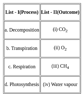
Detailed Solution for MH SET Paper 2 Mock Test - 3 (Geography) - Question 19

iii. Decomposition releases CH4 or methane.
iv. Transpiration releases Water vapour.
i. Respiration releases CO2 or carbon dioxide
ii. Photosynthesis releases O2 or oxygen.

Thus, the Correct answer is C.

MH SET Paper 2 Mock Test - 3 (Geography) - Question 20

With reference to Dispersed Settlements, consider the following:

1. These settlements are fragmented into several units physically separated from each other.

2. This segmentation of a large village is often motivated by social and ethnic factors.

3. Uttranchal, Himachal Pradesh and Kerala have this type of settlement.

Which of the above statement is/are not correct?

Detailed Solution for MH SET Paper 2 Mock Test - 3 (Geography) - Question 20
Statements 1 and 2 are incorrect.

Key Points Types of Human Settlements:

  • Hamleted Settlements:
    • A settlement is fragmented into several units physically separated from each other bearing a common name. Hence, statement 1 is not correct.
    • These units are locally called panna, para, palli, nagla, dhani, etc. in various parts of the country.
    • This segmentation of a large village is often motivated by social and ethnic factors. Hence, statement 2 is not correct.
    • Such villages are more frequently found in the middle and lower Ganga plain, Chhattisgarh and lower valleys of the Himalayas.
  • Dispersed Settlements:
    • Dispersed or isolated settlement pattern in India appears in the form of isolated huts or hamlets of a few huts in remote jungles, or on small hills with farms or pasture on the slopes.
    • Extreme dispersion of settlement is often caused by the extremely fragmented nature of the terrain and land resource base of habitable areas.
    • Many areas of Meghalaya, Uttaranchal, Himachal Pradesh and Kerala have this type of settlement. Hence, statement 3 is correct.
  • Clustered Settlements:
    • The clustered rural settlement is a compact or closely built-up area of houses.
    • In this type of village, the general living area is distinct and separated from the surrounding farms, barns and pastures.
  • Semi-clustered Settlements:
    • Semi-clustered or fragmented settlements may result from the tendency of clustering in a restricted area of dispersed settlement.
    • More often such a pattern may also result from the segregation or fragmentation of a large compact village.
MH SET Paper 2 Mock Test - 3 (Geography) - Question 21
The spread of cultural traits from one region to other is called:
Detailed Solution for MH SET Paper 2 Mock Test - 3 (Geography) - Question 21

The correct answer is Diffusion.

Key Points

  • The spread of cultural traits from one region to another is called cultural diffusion.
  • Cultural diffusion often occurs when people move from one place to another.
  • It is the geographical and social spread of the different aspects of one more culture to different ethnicities, religions, nationalities, regions, etc.

Additional Information

MH SET Paper 2 Mock Test - 3 (Geography) - Question 22
Who tried to combine the three branches of geography general, mathematical and physical, and, chorology in his book ‘Geographia Generalis’?
Detailed Solution for MH SET Paper 2 Mock Test - 3 (Geography) - Question 22

Correct Answer: Varenius.

Key Points

  • This was followed by another exclusive volume on the religions of Japan.
  • However, Varenius’ most significant contribution was his book, ‘Geographia Generalis’ (1650) which was one of the first attempts to combine three branches of geography—general (systematic), mathematical and physical—and, chorology (the science of space).
  • This book consisted of three parts:
    • The absolute or terrestrial part deals with the shape and size of the earth as well as the physical geography of continents, seas, and the atmosphere. 
    • The relative or the cosmic part describes the relation between the earth and other celestial bodies especially the sun and its effects on global climate. 
    • The comparative part focuses on the principles of navigation and the location of different places in relation to each other. 
  • In the preface of Geographia Generalis, Varenius advocated that the description of particular places should take into consideration the:
    • Celestial conditions—climate,
    • Terrestrial conditions—relief, soil, vegetation, and biotic life,
    • Human conditions—population, settlement, trade, forms of government. 

Important Points 

  • Geographia generalis (1650), Varenius’s best-known work, sought to lay down the general principles of geography on a wide scientific basis according to the knowledge of the day.
  • It not only was systematic geography on a scale not previously attempted but also contained a scheme for special, now known as regional, geography.
  • That major work was frequently revised, and the edition of 1672 had improvements by Sir Isaac Newton.
  • Varenius’ Geographia Generalis could have had a second volume but it could not be completed owing to his untimely and premature death in 1650. This book was translated into several editions in Latin.
MH SET Paper 2 Mock Test - 3 (Geography) - Question 23

Choose the correct option regarding 'Immigration'.

(A) People may move within a country or between countries

(B) People who leave a country

(C) When a person enters a new country.

Detailed Solution for MH SET Paper 2 Mock Test - 3 (Geography) - Question 23

The correct answer is Only C.

Key Points

  • Immigration is a process through which individuals become permanent residents or citizens of another country.
  • Historically, the process of immigration has been of great social, economic and cultural benefit to states.
  • It is the international movement of people to a destination country of which they are not natives or where they do not possess citizenship in order to settle as permanent residents or naturalised citizens.

 Thus, we can say that Immigration is when a person enters a new country.

MH SET Paper 2 Mock Test - 3 (Geography) - Question 24
Consider the following statements:-

a) Conduction is a slow process of heat transfer in terms of warming of the atmosphere.

b) The latent heat of evaporation and condensation are not quite responsible for the heating and cooling of the atmosphere.

c) Temperature over snow covered regions or grounds remain low even during daylight hours.

d) Loo is a typical example of the advection process.

Which of the following statements are correct?

Detailed Solution for MH SET Paper 2 Mock Test - 3 (Geography) - Question 24

Conduction is a slow process and hence is least important. As air is a very poor conductor of heat, the conduction affects only the uppermost layers of the lowermost layers of air closest to the earth's surface.

Temperature over snow covered grounds remain low during daylight as snow reflects a larger part of the incident solar radiation which is not available for heating the layers of the air lying adjacent to the surface.

Advection as a process of heat transfer is very important. Advection refers to the horizontal convection transport of heat. In the middle latitude regions, most of the diurnal variations in the daily weather are caused by advection itself. Hence, the scorching winds blowing during the summer in the northern plains of India are known as loo, a typical example of advection.

MH SET Paper 2 Mock Test - 3 (Geography) - Question 25
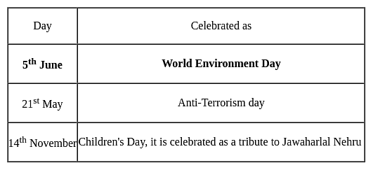
World Environment Day is celebrated on
Detailed Solution for MH SET Paper 2 Mock Test - 3 (Geography) - Question 25

World Environment Day:

  • It was established by the United Nations General Assembly in 1972 on the first day of the Stockholm Conference on the Human Environment.
  • World Environment Day is celebrated on 5th June of every year. United Nations started it to spread awareness and action for the protection of our environment.

Note that:

MH SET Paper 2 Mock Test - 3 (Geography) - Question 26
According to Malthus theory - 
Detailed Solution for MH SET Paper 2 Mock Test - 3 (Geography) - Question 26

Concept:

Malthus Theory:

  • The theory of exponential population and arithmetic food supply growth is the Malthusian theory of population.
  • Thomas Robert Malthus proposed this theory.
  • It was believed by him that preventive and positive checks are the two factors that can establish a balance between population growth and food supply.

Major elements of Malthus' theory:

  • Checks on Population
    • When the increasing population rate is greater than the food supply, there exists a condition of disequilibrium.
    • The result of this is that people will not get enough food even for survival.
    • People will die due to a lack of food supply.
    • Adversities such as epidemics, wars, starvation, famines, and other natural calamities are named positive checks by Malthus.
    • Then there are man-made checks which are named preventive checks by Malthus.

Explanation:

Key points of Malthus' theory:

  • Thomas Malthus warned that without any checks, the population would theoretically grow at an exponential rate, rapidly exceeding its ability to produce resources to support itself.
  • Malthus argued that an exponentially growing population will self-correct through war, famine, and disease.
  • Malthus stated that to avoid a catastrophe such as famine and war, people should opt an intentional population control, such as birth control and celibacy.
  • Malthusian catastrophes refer to naturally occurring checks on population growth such as famine, disease, or war.
  • These Malthusian catastrophes have not taken place on a global scale due to progress in agricultural technology.
  • However, many argue that future pressures on food production, combined with threats such as global warming, make overpopulation a still more serious threat in the future.

Key terms:

  • Carrying capacity: The number of individuals of a particular species that an environment can support.
  • Exponential growth: The growth in the value of a quantity, in which the rate of growth is proportional to the instantaneous value of the quantity.
  • Malthusian catastrophes: Naturally occurring checks on population growth such as famine, disease, or war are termed Malthusian catastrophes.

Thus, according to Malthus's theory population grows geometrically whereas resources grow arithmetically.

MH SET Paper 2 Mock Test - 3 (Geography) - Question 27

Given below are two statements, one is labeled as Assertion (A) and the other as Reason (R).

Assertion (A): Chile is the leading producer of copper in the world.

Reason (R): Andes Region of North Chile is enriched with the largest deposits of Porphyry copper.

Select the correct answer from the code given below :

Detailed Solution for MH SET Paper 2 Mock Test - 3 (Geography) - Question 27

The correct answer is ​Both (A) and (R) are true and (R) is the correct explanation of (A).

Key Points

  • Yes, Chile is an important producer of copper in the world and it is endowed with the world's largest deposit of porphyry copper.
  • Chile, the world's leading copper producer by far, produced an estimated 5.6 million metric tons of copper in 2021.
  • In second place is Peru, with an estimated copper mine production of 2.2 million metric tons in the same year.
  • Porphyry Cu deposits are the world's most important source of Cu and the Central Andes of South America hold some of the largest Cu resources worldwide.
    • In Argentina, many porphyry-type deposits and prospects with different degrees of exploration straddle along ~1500 km of the Central Andes.
    • The review and analysis of the tectonic-magmatic, metallogenic, and economic data of the better-known deposits and prospects allow defining the controls of porphyry-type mineralization and the metallogenic epochs and belts which in turn indicate the potential for porphyry-type mineralization in some relatively poorly explored segments of the Central Andes.
  • The world's third-largest copper producer from mines is China.
  • In India, major copper ore deposits are located in the Singhbhum district (Jharkhand), Balaghat district (Madhya Pradesh), and Jhunjhunu and Alwar districts (Rajasthan).
MH SET Paper 2 Mock Test - 3 (Geography) - Question 28

Consider the following statements regarding temperature inversion:

1. Long winter nights with clear skies and still air is an ideal condition.

2. It is common throughout the year in the polar areas.

3. In hills and mountains, inversion is the result of air drainage.

Which of the above statements is/are correct?
Detailed Solution for MH SET Paper 2 Mock Test - 3 (Geography) - Question 28
  • Normally, temperature decreases with increase in elevation. It is called normal lapse rate.
  • At times, the situation is reversed and the normal lapse rate is inverted. It is called Inversion of temperature.
  • Inversion is usually of short duration but quite common nonetheless.
  • A long winter night with clear skies and still air is an ideal situation for inversion.
  • The heat of the day is radiated off during the night and by early morning hours, the earth is cooler than the air above.
  • Over polar areas, temperature inversion is normal throughout the year.
  • Surface inversion promotes stability in the lower layers of the atmosphere. Smoke and dust particles get collected beneath the inversion layer and spread horizontally to fill the lower strata of the atmosphere.
  • Dense fogs in the mornings are common occurrences especially during winter. This inversion commonly lasts for a few hours until the sun comes up and begins to warm the earth.
  • The inversion takes place in hills and mountains due to air drainage.
  • Cold air at the hills and mountains, produced during night, flows under the influence of gravity.
  • Being heavy and dense, the cold air acts almost like water and moves down the slope to pile up deeply in pockets and valley bottoms with warm air above. This is called air drainage.
  • It protects plants from frost damages.
MH SET Paper 2 Mock Test - 3 (Geography) - Question 29
Given below are two statements- one is labelled as Assertion (A) and the other is labelled as Reason (R):

Assertion(A)- Fogs, urban smog’s, frost generally affect the economy.

Reason(R)- Inversion of temperature is known as the negative lapse rate.

Choose the correct options.

Detailed Solution for MH SET Paper 2 Mock Test - 3 (Geography) - Question 29

We all know, temperature decreases with increasing altitudes in the troposphere at an altitude of 6.5 degree Celsius per 1000 meters but this trend sometimes gets reversed under special circumstances and hence is known as negative lapse rate. Thus, warm air layer lies over cold air layer. However, because of this inversion of temperature, several significant changes can be observed. The significance of this reversal is that there are al lot of climatic effects that affect the surrounding environment as well as the economy.

MH SET Paper 2 Mock Test - 3 (Geography) - Question 30

Given below are two statements- one is labelled as Assertion (A) and the other is labelled as Reason (R):

Assertion(A)- The other name for doldrums is subtropical high-pressure belt.

Reason(R)- Frequent calm conditions exist in the equatorial low-pressure belt.

Choose the correct option:

Detailed Solution for MH SET Paper 2 Mock Test - 3 (Geography) - Question 30

The other name for doldrums is Equatorial low-pressure belt. It is the zone of convergence of trade winds blowing equator ward from the sub-tropical belts of high-pressure belts of high pressure in the northern and southern hemispheres. Within this belt the winds are light, variable and feeble with frequent calm conditions. That is why this belt is known as the belt of calms or doldrums. This belt is in the vicinity of the equator between latitudes 5-degree S and 5 degree north.

View more questions
60 tests
Information about MH SET Paper 2 Mock Test - 3 (Geography) Page
In this test you can find the Exam questions for MH SET Paper 2 Mock Test - 3 (Geography) solved & explained in the simplest way possible. Besides giving Questions and answers for MH SET Paper 2 Mock Test - 3 (Geography), EduRev gives you an ample number of Online tests for practice

Top Courses for MAHA TET

Download as PDF

Top Courses for MAHA TET