TS TET Exam  >  TS TET Tests  >  TS SET Mock Test Series 2024  >  TS SET Paper 2 Mock Test - 5 (Geography) - TS TET MCQ

TS SET Paper 2 Mock Test - 5 (Geography) - TS TET MCQ


Test Description

30 Questions MCQ Test TS SET Mock Test Series 2024 - TS SET Paper 2 Mock Test - 5 (Geography)

TS SET Paper 2 Mock Test - 5 (Geography) for TS TET 2025 is part of TS SET Mock Test Series 2024 preparation. The TS SET Paper 2 Mock Test - 5 (Geography) questions and answers have been prepared according to the TS TET exam syllabus.The TS SET Paper 2 Mock Test - 5 (Geography) MCQs are made for TS TET 2025 Exam. Find important definitions, questions, notes, meanings, examples, exercises, MCQs and online tests for TS SET Paper 2 Mock Test - 5 (Geography) below.
Solutions of TS SET Paper 2 Mock Test - 5 (Geography) questions in English are available as part of our TS SET Mock Test Series 2024 for TS TET & TS SET Paper 2 Mock Test - 5 (Geography) solutions in Hindi for TS SET Mock Test Series 2024 course. Download more important topics, notes, lectures and mock test series for TS TET Exam by signing up for free. Attempt TS SET Paper 2 Mock Test - 5 (Geography) | 100 questions in 120 minutes | Mock test for TS TET preparation | Free important questions MCQ to study TS SET Mock Test Series 2024 for TS TET Exam | Download free PDF with solutions
TS SET Paper 2 Mock Test - 5 (Geography) - Question 1

Economic development refers to________

Detailed Solution for TS SET Paper 2 Mock Test - 5 (Geography) - Question 1

Key Points

  • Economic Development is the creation of wealth from which community benefits are realized. It is more than a jobs program, it's an investment in growing your economy and enhancing the prosperity and quality of life for all residents. Economic development means different things to different people.
  • Economic development means the change in growth along with progressive changes in the socio-economic conditions of the country.
  • While Economic growth implies a change or an increase in the real output of the country. Growth must be accompanied by the progressive reduction in the inequalities and social vagaries for being called economic development. 

Economic development is not economic growth

  1. It’s easy to confuse development with growth, considering they have similar meanings and are often used interchangeably. Add the fact that economic growth is an important part of economic development. Economic growth is all about numbers. “Economic Growth is the positive change in the real output of the country in a particular span of time.”
  2. Economic growth is a straightforward measurement of actual economic output — things like gross domestic product (GDP) fall into this measurement. It’s a pure numbers game.
  3. But economic development is much broader in scope and includes elements that you might not normally associate with economics, like social welfare, early childhood education, and criminal justice reform.

Economic development refers to Economic growth plus changes in output distribution and economic structure. Therefore Option 2 is the correct answer.

TS SET Paper 2 Mock Test - 5 (Geography) - Question 2

Between 2010 and 2019, India's population grew at an average annual rate of:

Detailed Solution for TS SET Paper 2 Mock Test - 5 (Geography) - Question 2

The correct answer is 1.2%.

  • Between 2010 and 2019, India's population grew at an average annual rate of 1.2%.

Key Points

  • The United Nations Population Fund released the State of World Population 2019 report.
  • India’s population grew at an average annual rate of 1.2 per cent between 2010 and 2019 to 1.36 billion.
  • It was more than double the annual growth rate of China.
  • India also recorded an improvement in life expectancy at birth.
    • The life expectancy at birth in 1969 was 47 years and in 2019, it is 69 years.
  •  According to the report, in India, the total fertility rate per woman was 5.6 in 1969, dropping to 3.7 in 1994 and 2.3 in 2019.
  • The UNFPA report highlights that untold millions have enjoyed healthier and more productive lives in the 50 years since the agency was founded.
TS SET Paper 2 Mock Test - 5 (Geography) - Question 3

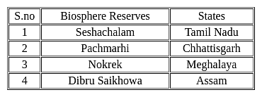
Consider the following pairs:

Which of the pairs given above are correctly matched?
Detailed Solution for TS SET Paper 2 Mock Test - 5 (Geography) - Question 3

The correct answer is 3 and 4 only.

Key Points

Additional Information

  • The Seshachalam Hills are hilly ranges part of the Eastern Ghats in Andhra Pradesh.
    • In 2010 it was designated as a Biosphere Reserve.
    • It has large reserves of red sandalwood which is used in medicines, soaps, spiritual rituals.
  • The Pachmarhi Biosphere Reserve is a biosphere reserve in the Satpura Range in Madhya Pradesh.
    • The conservation area was created in 1999 by the Indian government.
    • UNESCO designated it a biosphere reserve in 2009.
  • Nokrek Biosphere Reserve is a national park located in the West Garo Hills district of Meghalaya.
    • UNESCO added this National park to its list of Biosphere Reserves in May 2009.
  • Dibru-Saikhowa is a national park in Assam, India.
    • It is located in Dibrugarh and Tinsukia districts and was designated a Biosphere Reserve in July 1997.
TS SET Paper 2 Mock Test - 5 (Geography) - Question 4
Carbon dioxide contributes in trapping the heat radiated from the earth. It is known called
Detailed Solution for TS SET Paper 2 Mock Test - 5 (Geography) - Question 4

Carbon dioxide contributes in trapping the heat radiated from the earth. It is known called green house effect.

Key Points Green house effect: 

  • A greenhouse stays warm inside, even during the winter. In the daytime, sunlight shines into the greenhouse and warms the plants and air inside.
  • At nighttime, it's colder outside, but the greenhouse stays pretty warm inside.
  • That's because the glass walls of the greenhouse trap the Sun's heat.
  • The greenhouse effect works much the same way on Earth.
  • Gases in the atmosphere, such as carbon dioxide, trap heat similar to the glass roof of a greenhouse.
  • These heat-trapping gases are called greenhouse gases.
  • Human activities are changing Earth's natural greenhouse effect.
  • Burning fossil fuels like coal and oil puts more carbon dioxide into our atmosphere.

Some of the infrared radiation from the Sun passes through the atmosphere, but most is absorbed and re-emitted in all directions by greenhouse gas molecules and clouds. The effect of this is to warm the Earth's surface and the lower atmosphere.

TS SET Paper 2 Mock Test - 5 (Geography) - Question 5

Consider the following statements with reference to most of the western countries:

1. Males outnumber females in rural areas.

2. Females outnumber the males in urban areas.

Which of the above statement(s) is/are correct?

Detailed Solution for TS SET Paper 2 Mock Test - 5 (Geography) - Question 5

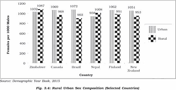
Rural Urban Composition

Source - NCERT

  • The rural and urban differences in sex ratio in Canada and West European countries like Finland are just the opposite of those in African and Asian countries like Zimbabwe and Nepal respectively. 
  • In Western countries, males outnumber females in rural areas and females outnumber the males in urban areas
  • In countries like Nepal, Pakistan and India the case is reversed
  • The excess of females in urban areas of U.S.A., Canada and Europe is the result of influx of females from rural areas to avail of the vast job opportunities. 
  • Farming in these developed countries is also highly mechanised and remains largely a male occupation. 
  • By contrast the sex ratio in Asian urban areas remains male dominated due to the predominance of male migration
  • Also, in countries like India, female participation in farming activity in rural areas is fairly high

Shortage of housing, high cost of living, paucity of job opportunities and lack of security in cities, discourage women from migrating from rural to urban areas.

TS SET Paper 2 Mock Test - 5 (Geography) - Question 6
Consider the following statements about the achievements of the Five-Year Plans-

a) balanced regional development

b) Eradication of poverty

c) Increasing trend in life expectancy

d) Technological development

Choose the correct option:-

Detailed Solution for TS SET Paper 2 Mock Test - 5 (Geography) - Question 6

The five-year plans were not able to achieve numerous fixed targets, but there has been constructive and socio-economic development. The failures were that the plans did not achieve any kind of balanced regional development. The eradication of poverty was also not achieved. Even during the year 2011-12, 21.9% of population of India was below the poverty Line.

TS SET Paper 2 Mock Test - 5 (Geography) - Question 7
Geographical transfer of culture traits by movements of people across space is which kind of diffusion-
Detailed Solution for TS SET Paper 2 Mock Test - 5 (Geography) - Question 7

The correct answer is Relocative
Key Points

Relocative:

  • It is the geographical transfer of culture traits by movements of people across space.
  • As the location continuously changes, this type of diffusion is coined relocation diffusion.
  • An example is the movement of a bush fire, which has burned out at the origin but continues to spread at the periphery.
  • Immigration from country to country, city to city, etc.
  • As they relocate to a new location, they bring their ideas, cultural tradition such as food, music, and more.

Additional InformationCulture diffusion

  • Culture diffusion, also often called cultural diffusion or transcultural diffusion, is a term from anthropology, specifically cultural anthropology, a subfield that focuses on how cultures vary among the human population. Cultural diffusion describes the spread of one culture’s practices, beliefs, and/or items, like food, music, or tools.
  • Hierarchical Diffusion
  1. It is when an idea spreads by passing first among the most connected individuals, then spreading to other individuals.
  2. Think of the chain of command in businesses, and the government.
  3. There’s somewhat of a hierarchy in terms of position of authority.

Expansion Diffusion

  1. Expansion diffusion is the spread of a factor or an innovation from a centre with the concentration of things being diffused throughout the society.

Contagious Diffusion

  1. It is the expansion which affects all the individuals and areas uniformly from a source region.
  2. The introduction of a new fashion trend which spreads like a wildfire through various social media sites can be cited as an example.
TS SET Paper 2 Mock Test - 5 (Geography) - Question 8
For finding Mode from formula class interval should be
Detailed Solution for TS SET Paper 2 Mock Test - 5 (Geography) - Question 8

Solution

For finding Mode from the formula class interval should be overlapping.

TS SET Paper 2 Mock Test - 5 (Geography) - Question 9
Over the last 100 years, the amount of CO2 in the atmosphere has increased by
Detailed Solution for TS SET Paper 2 Mock Test - 5 (Geography) - Question 9

The amount of CO2 has been increasing rapidly since the 1970s. In the last 100 years, the amount of carbon-dioxide has increased by 30% from 270 ppm to 350 ppm. The increase of carbon dioxide leads to increase in surface temperature.

TS SET Paper 2 Mock Test - 5 (Geography) - Question 10
Ellsworth Huntington demonstrated man’s preference for ethnic-type structures and environmentalist explanations in his book - 
Detailed Solution for TS SET Paper 2 Mock Test - 5 (Geography) - Question 10

Correct Answer: ​The Principles of Human Geography.

Key Points

  • Huntington ultimately sought to harmonize environmental and racial determinism, arguing that racial differences arose through natural selection propelled by climatic disparities and climate change.
  • He often hedged his racial arguments, however, unlike those based on environmental features.
  • The doctrine was further established by Ellsworth Huntington and Griffith Taylor.
  • Huntington's book 'The Principles of Human Geography (1945) and articles on climate and civilization demonstrated man’s preference for ethnic-type structures and environmentalist explanations.
  • However, he repeatedly repeated the importance of a genetic constitution and threw his weight behind various genetic enterprises (Spate, 1968).
  • He took the most decisive step since the time of Hippocrates and decided to make some results in the thinking of environmental causes. 
  • Though Huntington (1915, 68) emphasized the importance of climatic determinism but urged that it be ‘put into relation not only with the results of other factors of the physical environment but also with the opposite side of the shield, i.e., with the purely human factors’.
  • He even suggested that diet was as important as climate as an explanation of human energy.

Additional Information

  • Huntington’s generalizations on climatic determinism seem to be identical to those of Montesquieu, especially the one which he developed in his second book Civilisation and Climate (1915).
  • He stressed the importance of climatic determinism, In his book The Pulse of Asia (1907), he attempted to correlate the periods of drought with historical dates.

TS SET Paper 2 Mock Test - 5 (Geography) - Question 11

The primary contributor to the increase in atmospheric carbon dioxide, a major greenhouse gas, is most likely due to:

Detailed Solution for TS SET Paper 2 Mock Test - 5 (Geography) - Question 11

Option 3) ​Burning of fossil fuels like coal, oil, and gas

Carbon dioxide is a major greenhouse gas that contributes to global warming. The primary contributor to the increase in atmospheric carbon dioxide is the burning of fossil fuels.

Key Points

Burning of fossil fuels like coal, oil, and gas

  • The burning of fossil fuels is the primary contributor to the increase in atmospheric carbon dioxide.
  • Fossil fuels release carbon dioxide when they are burned, and this carbon dioxide accumulates in the atmosphere.
  • The burning of fossil fuels has increased significantly over time, as the world's population has grown and economies have developed.

Additional Information

Increased volcanic eruptions

Volcanic eruptions can release carbon dioxide into the atmosphere, but they are not the primary contributor to the increase in atmospheric carbon dioxide. Volcanic eruptions release a relatively small amount of carbon dioxide compared to human activities, and the amount of carbon dioxide released by volcanoes has not increased significantly over time.

Deforestation and land use changes

Deforestation and land use changes can release carbon dioxide into the atmosphere, but they are not the primary contributor to the increase in atmospheric carbon dioxide. Deforestation and land use changes release carbon dioxide when forests are cleared and the land is used for other purposes, such as agriculture or development. However, the amount of carbon dioxide released by deforestation and land use changes has decreased over time, as the rate of deforestation has slowed.

Changes in oceanic currents

Changes in oceanic currents can affect the amount of carbon dioxide in the atmosphere, but they are not the primary contributor to the increase in atmospheric carbon dioxide. Changes in oceanic currents can cause carbon dioxide to be released from the ocean into the atmosphere, or they can cause carbon dioxide to be absorbed by the ocean from the atmosphere. However, the amount of carbon dioxide released or absorbed by the ocean due to changes in oceanic currents is relatively small compared to the amount of carbon dioxide released by human activities.

Hence, Option 3) ​Burning of fossil fuels like coal, oil, and gas is the correct option.

TS SET Paper 2 Mock Test - 5 (Geography) - Question 12

According to the passage, the primary driver of global warming is:

Detailed Solution for TS SET Paper 2 Mock Test - 5 (Geography) - Question 12

Option 3) Human activities leading to greenhouse gas emissions

The primary driver of global warming is human activities leading to greenhouse gas emissions.

Key Points

Human activities leading to greenhouse gas emissions:

  • Human activities leading to greenhouse gas emissions are the primary driver of global warming.
  • Greenhouse gases trap heat in the atmosphere, causing the Earth's temperature to rise.
  • The main greenhouse gases released by human activities are carbon dioxide, methane, and nitrous oxide.

Additional Information

Increased volcanic activity: Increased volcanic activity is not the primary driver of global warming. Volcanic eruptions can release greenhouse gases into the atmosphere, but the amount of greenhouse gases released by volcanoes is relatively small compared to the amount of greenhouse gases released by human activities.

Natural fluctuations in solar radiation: Natural fluctuations in solar radiation can affect the Earth's climate, but they are not the primary driver of global warming. The amount of solar radiation reaching the Earth's surface has been relatively stable over the past century, while the Earth's temperature has continued to rise.

A sudden shift in Earth's magnetic field: A sudden shift in Earth's magnetic field is not the primary driver of global warming. The Earth's magnetic field protects the Earth from harmful solar radiation, but it does not affect the Earth's temperature.

Important Points

  • The burning of fossil fuels is the main human activity that leads to greenhouse gas emissions.
  • Fossil fuels release carbon dioxide into the atmosphere when they are burned.
  • Other human activities that lead to greenhouse gas emissions include deforestation, agriculture, and industrial processes.
TS SET Paper 2 Mock Test - 5 (Geography) - Question 13

Which is not an effect of ocean current on the socio-economic and climatic condition of the coastal region?

Detailed Solution for TS SET Paper 2 Mock Test - 5 (Geography) - Question 13

Ocean currents

  • Ocean currents are like rivers flowing in oceans.
  • They represent a regular volume of water in a definite path and direction.
  • Ocean currents are influenced by two types of forces namely :
    • Primary forces that initiate the movement of water;
    • Secondary forces that influence the currents to flow

Important Point

​​The primary forces that influence the currents are

  • Heating by solar energy
  • Wind
  • Gravity

Coriolis force

  • The Coriolis force intervenes and causes the water to move to the right in the northern hemisphere and to the left in the southern hemisphere.
  • These large accumulations of water and the flow around them are called Gyres.
  • These produce large circular currents in all the ocean basins.

Key Points

Effects of Ocean Currents

  • Ocean currents have a number of direct and indirect influences on human activities.
  • West coasts of the continents in tropical and subtropical latitudes (except close to the equator) are bordered by cool waters.
    • Their average temperatures are relatively low with narrow diurnal and annual ranges.
    • There is fog, but generally, the areas are arid.
  • West coasts of the continents in the middle and higher latitudes are bordered by warm waters which cause a distinct marine climate.
    • They are characterized by cool summers and relatively mild winters with a narrow annual range of temperatures.
  • Warm currents flow parallel to the east coasts of the continents in tropical and subtropical latitudes.
    • This results in warm and rainy climates.
    • These areas lie in the western margins of the subtropical anti-cyclones.
  • The mixing of warm and cold currents helps to replenish the oxygen and favor the growth of planktons, the primary food for the fish population.
    • The best fishing grounds of the world exist mainly in these mixing zones.

Hence, it is can be concluded from the above discussion that the deflection of wind due to the Coriolis force is not an effect of ocean current.

TS SET Paper 2 Mock Test - 5 (Geography) - Question 14
Which of the following local winds is also called "Doctor Wind"?
Detailed Solution for TS SET Paper 2 Mock Test - 5 (Geography) - Question 14
  • The Harmattan Wind in Niger which is also known as "the Doctor wind”, is a cool wind that brings relief from the major heat.
  • It is named so because of its invigorating dryness compared to the humid tropical air.
  • The Harmattan wind stream during the northern winter generally extends south of the equator as an upper air wind over the south-westerly monsoon.
TS SET Paper 2 Mock Test - 5 (Geography) - Question 15
Which of the following type was not included in seven-fold system of land classification given by L.D. Stamp?
Detailed Solution for TS SET Paper 2 Mock Test - 5 (Geography) - Question 15

Correct Answer: Rural areas.

Key Points

  • In general, land use classification has two components, under The assessment of physical quality and the agricultural potential of the land. This is also known as ‘land capability’. The physical properties of land are almost unchangeable. In fact, the character and quality of land and its soil depend on the parent material, temperature, rainfall, water-retaining capacity, soil texture, soil structure, and humus contents. These properties of land do not change over a shorter period of time.
  • The assessment of land quality under the prevailing set of socioeconomic circumstances including farm structure, availability of irrigation, the relative cost of labor, capital inputs, level of technology, and price stability. The economic and social controls on production are more variable. A number of land use classification systems are in vogue in different countries of the world.
  • The first systematic land classification was done by L.D. Stamp.
  • In his land classification of Britain, Stamp adopted a seven-fold system, i.e. Arable, Heath and rough, Pastures, Orchards and nurseries, Meadowland, Forest and woodland, and Urban areas.
  • The details and justification of this classification in Stamp’s monumental work The Land of Britain: Its Use and Misuse. This classification helped in overcoming many of the problems pertaining to the demand of land after the Second World War.
  • Subsequently, Coleman, a student of Stamp, adopted a classification of 13 major classes with various subdivisions, making 70 land-use types in all. The International Geographical Union (IGU) resolved to produce a unified classification system for the whole world but in the absence of adequate and reliable data, particularly about developing countries, it could not become possible.

Additional Information

  • In India, M. Shafi is the pioneer of land use studies. He published the Land Use Survey in Eastern Uttar Pradesh in 1962. Under his supervision, over two dozen students completed their doctoral theses in the field of agricultural land use studies. The availability of satellite imageries has revolutionized the whole technique of land use classification. The main weakness of the traditional land use survey is that it gives only a static description of existing land use and is very time, effort and money consuming.
TS SET Paper 2 Mock Test - 5 (Geography) - Question 16
The model of cliff recession was developed by
Detailed Solution for TS SET Paper 2 Mock Test - 5 (Geography) - Question 16

The cliff recession model, also known as Fisher- Lehman model, explains the process of cliff recession. Fisher in 1866 examined and interpreted the chalk cliffs in coastal areas and collection of basal debris apron. Lehmann in 1933 added the various stages of weathering to this Fisher's model.

TS SET Paper 2 Mock Test - 5 (Geography) - Question 17
The Dravidian races are mainly confined at which of the following parts of India?
Detailed Solution for TS SET Paper 2 Mock Test - 5 (Geography) - Question 17

The correct answer is South India.

Key Points

  • The Dravidian races are mainly confined to South India.
  • Dravidian races:
    • The people of Dravidian type are distributed in the region from Ceylon to the valley of the Ganges covering the southern part of India.
    • These especially include Western Bengal, Tamil Nadu, Andhra Pradesh (Hyderabad), Central India and Chotonagpur.
    • The best example of this type is the Paniyans of Malabar (South India) and the Santals of the Chottanagpur. 
    • Risley believed these people as original inhabitants of India who are found to be modified at present by the infiltration of the Aryans, the Scythians and the Mongoloids.
    • The Dravidians were the majority population across the Indian subcontinent before the second millennium.
    • The evidence of early Dravidians comes from studying the Indo-Aryan culture, languages, and findings at many mounds, the preeminent of which are Mohenjodaro in Punjab and Harappa in Larkana District in Sind.

Additional Information

  • Dravidian languages:
    • Dravidian languages, a family of some 70 languages spoken primarily in South Asia.
    • The Dravidian languages are spoken by more than 215 million people in India, Pakistan, and Sri Lanka.
    • The Dravidian languages are divided into South, South-Central, Central, and North groups; these groups are further organized into 24 subgroups.
    • The four major literary languages—Telugu, Tamil, Malayalam, and Kannada—are recognized by the constitution of India.
    • They are also the official languages of the states of Andhra Pradesh, Tamil Nadu, Kerala, and Karnataka (formerly Mysore), respectively.
    • There is considerable literature on the theory that India is a linguistic area where different language families have developed convergent structures through extensive regional and societal bilingualism.
    • It is now well established that the Indo-Aryan and Dravidian language families developed convergent structures in sound system (phonology) and grammar owing to contact going back to the 2nd millennium BCE.
    • The earliest varieties of Indo-Aryan are forms of Sanskrit.
TS SET Paper 2 Mock Test - 5 (Geography) - Question 18
Between 2010 and 2019, India's population grew at an average annual rate of:
Detailed Solution for TS SET Paper 2 Mock Test - 5 (Geography) - Question 18

The correct answer is 1.2%.

  • Between 2010 and 2019, India's population grew at an average annual rate of 1.2%.

Key Points

  • The United Nations Population Fund released the State of World Population 2019 report.
  • India’s population grew at an average annual rate of 1.2 per cent between 2010 and 2019 to 1.36 billion.
  • It was more than double the annual growth rate of China.
  • India also recorded an improvement in life expectancy at birth.
    • The life expectancy at birth in 1969 was 47 years and in 2019, it is 69 years.
  •  According to the report, in India, the total fertility rate per woman was 5.6 in 1969, dropping to 3.7 in 1994 and 2.3 in 2019.
  • The UNFPA report highlights that untold millions have enjoyed healthier and more productive lives in the 50 years since the agency was founded.
TS SET Paper 2 Mock Test - 5 (Geography) - Question 19
Which of the following is NOT an example of rocks?
Detailed Solution for TS SET Paper 2 Mock Test - 5 (Geography) - Question 19

The correct answer is Asphalt.

Key Points

  • Asphalt concrete is one of the most common types of pavement surface materials used in the world. It is a porous material made at a very high temperature of about 180°C that consists of a mixture of asphalt binder (bitumen), aggregate particles, and air voids. After some years of usage, the stiffness of asphalt concrete increases, and its relaxation capacity decreases. The binder becomes more brittle, then micro-cracks develop in it and cracking of the interface between aggregates and binder occurs.

Additional Information

  • Granite:
    • Granite is unstratified rock, plutonic igneous rock, silicious rock
    • Granite is hard, the coarse-grained rock of crystalline structure.
    • It is a type of igneous rock (plutonic rock).
  • Schist is a type of Metamorphic rock.
  • Basalt rock is an example of Extrusive igneous rock.
TS SET Paper 2 Mock Test - 5 (Geography) - Question 20
The ozone layer helps to protect life from which harmful radiation?
Detailed Solution for TS SET Paper 2 Mock Test - 5 (Geography) - Question 20

The correct answer is Ultraviolet radiation

Key Points

  • The ozone layer is one of the layers in the earth’s atmosphere inside the stratosphere layer.
  • It absorbs ultraviolet radiation and protects people, animals, plants, and marine life from the sun’s harmful rays.
  • It was discovered by Charles Fabry and Henri Buisson in 1913.
  • It can absorb 98% of the sun’s ultraviolet rays and almost 90% of ozone is located in the stratosphere layer at a distance of 15 to 30 km from the surface of Earth.
  • In 1989, the Montreal protocol came to protect the ozone layer by cutting the substances that deplete the ozone layer.

Additional Information

  • Ozone, or trioxygen, is an inorganic molecule with the chemical formula O ₃.
  • It is a pale blue gas with a distinctively pungent smell. It is an allotrope of oxygen that is much less stable than the diatomic allotrope O ₂, breaking down in the lower atmosphere to O ₂.
  • Ozone is a particularly effective absorber of UV radiation.
  • The ozone layer in the stratosphere absorbs a portion of the radiation from the sun, preventing it from reaching the planet's surface. Most importantly, it absorbs the portion of UV light called UVB.
  • UVB is a kind of ultraviolet light from the sun (and sun lamps) that has several harmful effects.
TS SET Paper 2 Mock Test - 5 (Geography) - Question 21

Depletion of ozone molecules in the stratosphere is due to

Detailed Solution for TS SET Paper 2 Mock Test - 5 (Geography) - Question 21
  • Our atmosphere is divided into five layers starting from the earth’s surface. These are Troposphere, Stratosphere, Mesosphere, Thermosphere and Exosphere.
  • Stratosphere: Above the troposphere lies the stratosphere. It extends up to a height of 50 km. This layer is almost free from clouds and associated weather phenomenon, making conditions most ideal for flying aeroplanes.
  • One important feature of stratosphere is that it contains a layer of ozone gas. This prevents the harmful radiations from sun, reaching the surface of the Earth where they may damage many forms of life. Ozone is a triatomic molecule of oxygen.
  • It was discovered that this ozone layer was getting depleted. Various man-made compounds like CFCs (carbon compounds having both fluorine and chlorine which are very stable and not degraded by any biological process) were found to persist in the atmosphere.
  • Once they reached the ozone layer, they would react with the ozone molecules. One chlorine atom can destroy over 100,000 ozone molecules before it is removed from the stratosphere.
  • There is a halogen group in periodic table contains fluorine (F), chlorine (Cl), bromine (Br), iodine (I), and astatine (At).
TS SET Paper 2 Mock Test - 5 (Geography) - Question 22

Use the map below showing the main agricultural regions in China to answer the question that follows.
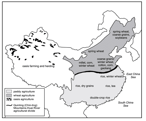
To explain the origins of the regional difference in Chinese agricultural production shown in the map, which of the following types of information would be most useful?

Detailed Solution for TS SET Paper 2 Mock Test - 5 (Geography) - Question 22

This question requires the examinee to demonstrate knowledge of basic cartographic concepts and how to interpret information in maps, charts, diagrams, and other graphic formats. Physical geography and climate are the primary determinants of those forms of agricultural activity that are most appropriate in a given region. Whereas a sloping topography and scarce rainfall limit large parts of western China to oasis farming and herding, many eastern areas of the country possess physical attributes that make them well suited for extensive production of various types of grains.

TS SET Paper 2 Mock Test - 5 (Geography) - Question 23
The Peru-Chile Trench has been formed due to
Detailed Solution for TS SET Paper 2 Mock Test - 5 (Geography) - Question 23

The Convergence of plates or convergent boundaries refer to the situation where two plates moving from opposite directions come closer to each other. The Peru-Chile trench has been formed due to the convergence of the Nazca Oceanic plate and the South American continental plate. Here subduction of plates is a common thing and is a supporting reason for the formation of trenches.

TS SET Paper 2 Mock Test - 5 (Geography) - Question 24
Consider the following statements:

i. With the technological advancement, the environment has affected beyond recognition.

ii. Mega cities and conurbation have not much affected the environmental conditions as they are developed in an environment friendly way.

iii. Global warming is an impact of technological advancement.

iv. Acid rain is due to the frontal formations.

Choose the correct option from below:

Detailed Solution for TS SET Paper 2 Mock Test - 5 (Geography) - Question 24

Environment change is a continuous process that has been in operation from a very long time. Right from the primeval stage of human development man has been interacting with environment. With the advancement of technologies, the environment of earth has been transformed beyond recognition. Mega cities, Conurbation, modern towers are some of examples of these technological advancement.

TS SET Paper 2 Mock Test - 5 (Geography) - Question 25

With reference to the Tropical Cyclones, consider the following statements:

1. Cyclone forming over land has an effect over a large area.

2. If a cyclone stays at a place, rains may continue for a longer duration than average.

3. Temperature of ocean water must be higher than approx 27oC for the formation of cyclones.

 How many of the statements given above are correct?


Detailed Solution for TS SET Paper 2 Mock Test - 5 (Geography) - Question 25

The correct answer is Only two.

Key Points

  • A Tropical cyclone is an intense circular storm that originates over warm tropical oceans and is characterized by low atmospheric pressure, high winds, and heavy rain.
  • These cyclones are organized low-pressure systems of clouds and thunderstorms that form over tropical or subtropical waters.
  • They rotate counterclockwise in the Northern Hemisphere and clockwise in the southern hemisphere.
  • They develop in the regions between both tropics.
  • Features:-
    •  A tropical cyclone has an effect on a comparatively smaller area.
      • It forms only on seas with temperatures more than  27oC and dissipates on reaching the land. Hence, statement 1 is not correct.
      • Note:- Temperate cyclones can be formed on both land and sea.
    • Tropical cyclones can persist for many days and may follow quite erratic paths. 
    • Eye of cyclone develops. 
    • It causes heavy rainfall for a few hours but, if it stays at a place, rains may continue for a longer duration. Hence, statement 2 is correct.
    • It derives its energy from the latent heat of condensation.
    • The speed of this cyclone is almost 200 km or more.
  • Conditions required for the formation of Tropical cyclone:
    • ​Pre-existing low-pressure area.
    • Sufficient warm temperature at sea surface i.e: higher than 27o C. Hence, statement 3 is correct.
    • Presence of Coriolis force.
    • Low vertical wind shear.
    • Atmospheric instability.
TS SET Paper 2 Mock Test - 5 (Geography) - Question 26

Which pair is not twin-cities?

Detailed Solution for TS SET Paper 2 Mock Test - 5 (Geography) - Question 26

New Delhi which is Indian capital is a territory inside Delhi. It is a part of big territory i.e. Delhi.

TS SET Paper 2 Mock Test - 5 (Geography) - Question 27
Which of the following is the correct description of a ‘Hydrological Drought’?
Detailed Solution for TS SET Paper 2 Mock Test - 5 (Geography) - Question 27
The correct answer is Option 2.
Key Points
Drought
  • Drought refers to a situation when there is a shortage of water availability due to inadequate precipitation, excessive evaporation rate, over-utilisation of water from reservoirs etc.
  • It is the world’s most costly natural hazard which impacts very large areas compared to other disasters.
  • It leads to significant losses in the economy, ecology, and environment.
Types of Droughts:
  • Meteorological Drought:
    • It occurs when water shortages are caused by an imbalance in precipitation and evaporation. Hence, option 1 is incorrect.
  • Hydrological Drought:
    • A situation when there is inadequate surface and subsurface water in a water resource management systemHence, option 2 is correct.
  • Agricultural Drought:
    • A situation arises when there is inadequate soil moisture that is necessary to support the crops. Thus, it leads to crop failures and later food shortages. Hence, option 3 is incorrect.
  • Ecological Drought:
    • It occurs when the productivity of a natural ecosystem fails due to water shortages causing environmental distress. Hence, option 4 is incorrect.
TS SET Paper 2 Mock Test - 5 (Geography) - Question 28

Given below are some human activities:

A. Digging of mines

B. Constructing dams

C. Collection of leaves and herbs to sell them in the market

D. Weaving baskets from bamboo

E. Making leaf plates out of fallen leaves.

Which of the following statements are responsible for the disappearance of forests ?

Detailed Solution for TS SET Paper 2 Mock Test - 5 (Geography) - Question 28

Option 2 is the correct answer: Activities mentioned in A and B statements are responsible for the disappearance of forests.

  • Digging of Mines: Some of the mineral ores are located in the forest areas or under tree cover. In order to extract them out, the land is cleared for mining by cutting down the trees. Therefore mining leads to the disappearance of forests.
  • Dam constructions: A large mountainous area covered with trees are submerged under reservoir water after dam construction leading to the disappearance of forests.
  • The activities mentioned in C, D and E although derive the raw material from forests but they don’t lead to the disappearance of forest. For the proper and continuous supply of these raw materials from forests, these activities promote forest conservation instead.

India State of Forest Report  (ISFR) 2019:

  • It is a biennial report published by the Forest Survey of India (FSI).
  • The first report was released in 1987 and the ISFR 2019 report was the 16th report in the series.
  • According to it the total tree and forest cover in India is 24.56% of its total geographical area.
  • Madhya Pradesh, Arunachal Pradesh and Chhattisgarh are the top rankers in terms of area wise forest cover.
  • Mizoram, Arunachal Pradesh and Meghalaya have the highest percentage-wise forest cover area.
TS SET Paper 2 Mock Test - 5 (Geography) - Question 29
Which is the shallowest part of the ocean, showing an average gradient of 1° or even less and it typically ends at a very steep slope?
Detailed Solution for TS SET Paper 2 Mock Test - 5 (Geography) - Question 29

The correct answer is Continental Shelf.

Key Points

  • Continental Shelf is the shallowest part of the ocean, showing an average gradient of 1° or even less and it typically ends at a very steep slope.
  • Continental Shelf:
    • It is the gently sloping seaward extension of the continental plate.
    • It is the shallowest part of the ocean.
    • These are created due to sedimentation from the continents.
    • Continental Shelf is the gently sloping seaward extension of the continental plate.
    • The continental shelves are covered with variable thicknesses of sediments brought down by rivers, glaciers, etc.
    • The shelves are almost absent or very narrow along some of the margins like the coasts of Chile, the west coast of Sumatra, etc. [Ocean - Continent Convergence and Ocean - Ocean Convergence].
    • Continental shelves are located in photic zones, so have rich marine ecology.
    • The Continental Shelf of all oceans together covers 7.5% of the total area of the oceans.

Additional Information

  • Ocean Floor Division can be divided into various parts such as Continental Shelf, Continental Slope, Continental Rise or Foot, Deep Ocean basins, Abyssal plains or Deep Sea plain, Oceanic Trenches, Seamounts, and Guyots.
  • Deep-Sea Plain or Abyssal plain:
    • These plains are gently sloping areas of the ocean basins.
    • These are the flattest and smoothest regions of the world.
    • It is an underwater plain on the deep ocean floor, usually found at depths between 3,000 and 6,000m.
    • These plains are covered with fine-grained sediments like clay and silt.
    • Lying generally between the foot of a continental rise and a mid-ocean ridge, abyssal plains cover more than 50% of the Earth's surface.
  • Oceanic Deeps or Trenches:
    • These areas are the deepest parts of the oceans.
    • The trenches are relatively steep-sided, narrow basins.
    • They are some 3-5 km deeper than the surrounding ocean floor.
    • They occur at the bases of continental slopes and along island arcs and are associated with active volcanoes and strong earthquakes.
  • Continental Slope:
    • The continental slope ties the continental shelf and the rising of the continent.
    • The continental shelf stops as the slope rises sharply. From here, the continental slope begins.
    • A sudden change in the gradient to around 1 in 20 occurs. With young mountain ranges and narrow continental shelves, the slope gradient is highest off coasts and lowest off stable coasts without large rivers.
    • Most Pacific slopes are steeper than Atlantic slopes.
TS SET Paper 2 Mock Test - 5 (Geography) - Question 30
Who propounded the concept of paradigm?
Detailed Solution for TS SET Paper 2 Mock Test - 5 (Geography) - Question 30

There have been various evolutionary phases in geography. It passed from descriptive and teleological phase to the quantitative radical and dialectical materialism stage. There was a shift of approaches that were conventionally used to a set of new ways of approaches. This was called paradigm which was for the first time propounded by Thomas Kuhn in 1962.

View more questions
60 tests
Information about TS SET Paper 2 Mock Test - 5 (Geography) Page
In this test you can find the Exam questions for TS SET Paper 2 Mock Test - 5 (Geography) solved & explained in the simplest way possible. Besides giving Questions and answers for TS SET Paper 2 Mock Test - 5 (Geography), EduRev gives you an ample number of Online tests for practice
Download as PDF