TS TET Exam  >  TS TET Tests  >  TS SET Mock Test Series 2024  >  TS SET Paper 2 Mock Test - 9 (Geography) - TS TET MCQ

TS SET Paper 2 Mock Test - 9 (Geography) - TS TET MCQ


Test Description

30 Questions MCQ Test TS SET Mock Test Series 2024 - TS SET Paper 2 Mock Test - 9 (Geography)

TS SET Paper 2 Mock Test - 9 (Geography) for TS TET 2025 is part of TS SET Mock Test Series 2024 preparation. The TS SET Paper 2 Mock Test - 9 (Geography) questions and answers have been prepared according to the TS TET exam syllabus.The TS SET Paper 2 Mock Test - 9 (Geography) MCQs are made for TS TET 2025 Exam. Find important definitions, questions, notes, meanings, examples, exercises, MCQs and online tests for TS SET Paper 2 Mock Test - 9 (Geography) below.
Solutions of TS SET Paper 2 Mock Test - 9 (Geography) questions in English are available as part of our TS SET Mock Test Series 2024 for TS TET & TS SET Paper 2 Mock Test - 9 (Geography) solutions in Hindi for TS SET Mock Test Series 2024 course. Download more important topics, notes, lectures and mock test series for TS TET Exam by signing up for free. Attempt TS SET Paper 2 Mock Test - 9 (Geography) | 100 questions in 120 minutes | Mock test for TS TET preparation | Free important questions MCQ to study TS SET Mock Test Series 2024 for TS TET Exam | Download free PDF with solutions
TS SET Paper 2 Mock Test - 9 (Geography) - Question 1

Consider the following statements:

1. Bhabar is a narrow belt that runs in the East-West direction along the foot of the Himalayas from river Indus to Jhelum.

2. The Bhabar plains are not suitable for the cultivation of crops.

Which of the following is/are correct?

Detailed Solution for TS SET Paper 2 Mock Test - 9 (Geography) - Question 1

The correct answer is 2 only.

Key Points

  • Bhabar Plains:
    • Bhabar is a narrow belt that runs in the east-west direction along the foot of the Himalayas from the river Indus to Teesta. Hence statement 1 is incorrect
    • Rivers that descend from the Himalayas, deposit their sediments along the foothills in the form of alluvial fans.
    • These alluvial fans consist of coarser sediments that have merged together to build up the piedmont plain i.e. the Bhabar.
    • It is not suitable for the cultivation of crops. Hence statement 2 is correct
      • Only trees with large roots thrive in the region.

Additional Information

  •  The northern plains of India include:
    • The Bhabar
    • The Terai
    • The Bhangar
    • The Khadar
TS SET Paper 2 Mock Test - 9 (Geography) - Question 2

Whose essay is “Exploring new ethics for survival”

Detailed Solution for TS SET Paper 2 Mock Test - 9 (Geography) - Question 2

 Environmental ethics got involved in academic field in response to the works of Rachel Carson and Murray Bookchin. First earth day was celebrated in 1970. Thereafter various writers, philosophers, environmentalists started contributing their works to the field. One of them was the essay written by Garrett Hardin titled “Exploring new ethics for survival”

TS SET Paper 2 Mock Test - 9 (Geography) - Question 3

Which of the following is the chief characteristic of ‘mix farming’ ?

Detailed Solution for TS SET Paper 2 Mock Test - 9 (Geography) - Question 3

The main characteristics of the mixed farming are that farms produce both crops and livestock and the two enterprises are interwoven and integrated. The grass is an important crop of mixed farming system, occupying at least 20 per cent of the cultivated land.

TS SET Paper 2 Mock Test - 9 (Geography) - Question 4
The term ‘Umland’ refers to:
Detailed Solution for TS SET Paper 2 Mock Test - 9 (Geography) - Question 4

The correct answer is Area surrounding a town.
Key PointsUmland

  • In geography, "Umland" is a German term that refers to the surrounding countryside or hinterland of a town or city.
  • It includes the rural areas, suburbs, and small towns that are closely connected to the urban center in terms of economic, social, and cultural ties.
  • Umland is also used to describe the functional region that is influenced by the urban center, including the commuting zone and the trade area.
  • The concept of Umland is important in urban geography and regional planning because it reflects the spatial relationships and interdependencies between urban and rural areas.
  • The Umland provides resources, such as food, water, and energy, to the urban center, while the city provides jobs, services, and markets to the surrounding region.
  • The development of Umland can also affect the environment, as land use changes and urbanization alter the natural and agricultural landscapes.

Additional Information

  1. Heart of a town: This term refers to the central or downtown area of a town or city, often where the commercial and cultural activities are concentrated. The heart of a town is typically the oldest and most densely populated part of the urban center.

  2. Residential area of a town: This term refers to the parts of a town or city that are primarily used for housing. Residential areas can range from high-density apartment complexes to low-density suburban neighborhoods, depending on the size and structure of the town.

  3. Satellite town: This term refers to a town or city that is located near a larger urban center but is independent and self-sufficient in terms of its economy and services. Satellite towns are often built to accommodate the growing population and economic activities of the urban center, but also to provide an alternative living and working environment.

While these terms are related to the concept of a town or city, they refer to specific aspects of the urban or peri-urban landscape, whereas Umland refers more generally to the surrounding region that is closely connected to the town or city.

TS SET Paper 2 Mock Test - 9 (Geography) - Question 5

Given below are two statements. One is labelled as Assertion (A) and the other is labelled as Reason (R).

Assertion (A): Foreign Direct Investment is not beneficial for economic growth.

Reason (R) : Foreign Direct Investment increases trade in the economy.

Select the correct answer from options given below:

Detailed Solution for TS SET Paper 2 Mock Test - 9 (Geography) - Question 5

Foreign Direct Investment means that companies from other countries invest in the companies in the host country. This provides employment to workers and increases the foreign currency in the country. Utilization of available resources is also done. The FDI facilitates trade as the amount of finished product increase. Thus, it is helpful for economic growth. Thus, (R) is true and (A) is false.

TS SET Paper 2 Mock Test - 9 (Geography) - Question 6

Which of the following Railway zones and their Headquarters is not correct?

Detailed Solution for TS SET Paper 2 Mock Test - 9 (Geography) - Question 6

South-Central-Hyderabad Railway zones and their Headquarters is not correct. Secunderabad Division was split into two Divisions viz. Secunderabad and Hyderabad on 17-Feb-1978. Following re-organisation of zones and Divisions with effect from 01-04-2003, two new Divisions viz., Guntur and Nanded were operationalised duly transferring Hubli Division to newly formed South Western Railway.

TS SET Paper 2 Mock Test - 9 (Geography) - Question 7

Consider the following statements .

(A) Rock is an aggregate of one or more minerals with definite composition of consituent minerals.

(B) Minerals are created by natural process without any human interference.

Choose the correct option.

Detailed Solution for TS SET Paper 2 Mock Test - 9 (Geography) - Question 7

The correct answer is (A) is false, (B) is true.

Key PointsThe question is about the characteristics of rocks and minerals.

  • A rock is as an aggregate of one or more minerals without a definite composition of constituent minerals.
  • That means it is composed of multiple minerals grouped together.
  • The minerals in a rock may come in many different shapes, sizes, and combinations.
  • Rocks usually don't have a specific chemical formula, as they are composed of many different minerals, each with its own chemical composition.
  • Minerals are naturally occurring substances that are formed through geological processes without any human interference.
  • Minerals, on the other hand, are naturally occurring substances that are solid, stable at room temperature, representable by a chemical formula, usually abiogenic (formed by geological processes), and have an ordered atomic structure.
TS SET Paper 2 Mock Test - 9 (Geography) - Question 8
Consider the following statements about ecological factors:-

i. Light and temperature are direct ecological factors.

ii. Indirect factors include soil structure, altitude, wind and slope.

iii. Edaphic factors and biotic factors can be included in physical factors.

Choose the correct option from below:

Detailed Solution for TS SET Paper 2 Mock Test - 9 (Geography) - Question 8

 The environment is an amalgamation of various features called factors. These are the product of forces and process of nature and are universal and inherent all over the earth. These factors are classified into two groups direct factors and indirect factors. The direct factors are light, temperature, soil air, water etc. and indirect factors include soil structure, soil organisms, altitude, wind, slope, etc.

Thus, the correct answer is D.

TS SET Paper 2 Mock Test - 9 (Geography) - Question 9

Consider the following:

1. Proximity of the jute-producing areas

2. Inexpensive water transport

3. Availability of economical labor

4. Abundant water for processing raw jute

How many of the above are responsible factors for the location of the Jute industry in the Hugli basin?

How many of the statements given above are correct?

Detailed Solution for TS SET Paper 2 Mock Test - 9 (Geography) - Question 9

The correct answer is All fourKey PointsJute industry:

  • India is the largest producer of jute followed by Bangladesh and China.
  • However, in terms of acreage and trade, Bangladesh takes the lead accounting for three-fourths of the global jute exports in comparison to India’s 7%.
  • Major jute-producing states include West Bengal, Bihar, Odisha, Assam, Andhra Pradesh, Meghalaya and Tripura.
  • It is known as the golden fibre.
  • It is used in making gunny bags, mats, ropes, yarn, carpets and other artefacts.
  • The factors behind the present localization of the jute industry in Eastern India especially West Bengal are:
    • Raw material: West Bengal is the largest producer of jute and most mills are located there;
    • Water supply: High rainfall and the presence of rivers ensure abundant water for processing raw jute;
    • Easy Transportation: The region is well connected by a good network of railways, waterways, and roadways to facilitate the movement of raw materials to the mills.
    • Inexpensive water transport is also provided by the Hugli river;
    • Labour: Availability of economical labour from West Bengal and the adjoining States of Bihar, Orissa, and Uttar Pradesh;
    • Kolkata as a port and large urban centre, provides banking, insurance, and port facilities for the export of jute goods. Hence, statements 1, 2, 3 and 4 are correct.
TS SET Paper 2 Mock Test - 9 (Geography) - Question 10
In which ocean is the "Sunda Trench" located?
Detailed Solution for TS SET Paper 2 Mock Test - 9 (Geography) - Question 10

The "Sunda Trench" is located in the Indian Ocean.

Key Points

  • Oceanic Trenches are the areas which are the deepest parts of the oceans.
  • The trenches are relatively steep sided with narrow basins.
  • They are some 3-5 km deeper than the surrounding ocean floor.
  • They occur at the bases of continental slopes and along island arcs and are associated with active volcanoes and strong earthquakes.
  • The Sunda Trench, earlier known as and sometimes still indicated as the Java Trench, is an oceanic trench located in the Indian Ocean near Sumatra.
  • It is formed where the Australian-Capricorn plates subduct under a part of the Eurasian Plate.
  • It is 3,200 kilometres long with a maximum depth of 7,290 metres (23,920 feet). 
  • Its maximum depth is the deepest point in the Indian Ocean

Therefore, we can conclude that the "Sunda Trench" is located in the Indian Ocean.

TS SET Paper 2 Mock Test - 9 (Geography) - Question 11

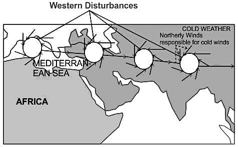
During the cold weather season, in the northern plains, there will be an inflow of cyclonic disturbances from the ______ directions.

Detailed Solution for TS SET Paper 2 Mock Test - 9 (Geography) - Question 11

The Correct Answer is West and Northwest.

Key Points

  • Western Disturbances
    • Western Disturbances begin is a low-pressure system that originates in the Mid-latitude region near the Atlantic Ocean and Europe.
  • Western Disturbances develop in the mid-latitude region (north of the Tropic of Cancer), not in the tropical region, therefore they are called mid-latitude storms or extra-tropical storms
  • A characteristic feature of the cold weather season over the northern plains is the inflow of cyclonic disturbances from the west and the northwest.
  • These low-pressure systems, originate over the Mediterranean Sea and western Asia and move into India, along with the westerly flow.
  • They cause much-needed winter rains over the plains and snowfall in the mountains.

Additional Information

  • The low pressure typically forms over the Mediterranean Sea and travels over Iran, Iraq, Afghanistan, and Pakistan before entering India loaded with moisture.
  • This disturbance is usually associated with a cloudy sky, higher night temperatures, and unusual rain.
  • These moisture-laden western disturbances eventually come up against the Himalayas and get blocked, as a consequence, the moisture gets trapped and precipitation is shared in the form of snow and rain over Northwest India and sometimes, other parts of North India.
  • The rainfall during the winter season helps agriculture, particularly for rabi crops including wheat, which is one of the most important Indian crops.
TS SET Paper 2 Mock Test - 9 (Geography) - Question 12

Which of the following is/are example(s) of the assertion that cultural differences existing in the world is the outcome of human interaction with the environment?

(A) People of Amazon basin live in houses with a steeply slanting roof.

(B) People of Amazon practice 'slash and burn agriculture'.

(C) People in Bihar and Assam make handicrafts from silk.

Detailed Solution for TS SET Paper 2 Mock Test - 9 (Geography) - Question 12

The correct answer is: All (A), (B), and (C)
Important Points

All of the given examples demonstrate how cultural differences can be attributed to human interaction with the environment:

(A) People of the Amazon basin live in houses with a steeply slanting roof.

  • This architectural style is influenced by the heavy rainfall in the region.
  • The steeply slanting roofs help to quickly shed water and prevent it from accumulating on the roof.

(B) People of the Amazon practice 'slash and burn agriculture'.

  • This farming method involves cutting down and burning vegetation to clear land for cultivation.
  • It is adapted to the environment of the Amazon rainforest, where the soil is nutrient-poor.
  • The ashes from the burning provide temporary fertility for crops.

(C) People in Bihar and Assam make handicrafts from silk.

  • The availability of silk-producing insects such as silkworms in these regions has led to the development of silk-based handicrafts.
  • The local environment provides the necessary resources for silk production and encourages the development of related cultural practices.

Therefore, all of the given examples illustrate how cultural differences are influenced by human interactions with the environment.

TS SET Paper 2 Mock Test - 9 (Geography) - Question 13
Which of the following industries is NOT a significant contributor to the economy of Bihar?
Detailed Solution for TS SET Paper 2 Mock Test - 9 (Geography) - Question 13

The correct answer is Automobile Manufacturing

Key Points

  • Bihar, an eastern state of India, has a diverse economy with several key industries. Agriculture is a major sector, with a significant portion of the population engaged in farming. The state is a major producer of crops like rice, wheat, and maize.
  • The food processing industry is another major contributor, closely linked with agriculture. It involves the processing of fruits, vegetables, dairy products, meat, and grains, adding value to agricultural produce and creating employment opportunities.
  • The textile industry, particularly silk and cotton, is also significant in Bihar. The state is known for its Bhagalpuri silk, and the textile industry provides employment to a large number of people and contributes to the state's exports.
TS SET Paper 2 Mock Test - 9 (Geography) - Question 14

In manufacturing industries of India, a micro enterprise is an enterprise where investment in plant and machinery does not exceed ____?

Detailed Solution for TS SET Paper 2 Mock Test - 9 (Geography) - Question 14

In manufacturing industries of India, a micro enterprise is an enterprise where investment in plant and machinery does not exceed Rs. 25 Lakh.

TS SET Paper 2 Mock Test - 9 (Geography) - Question 15
Which of the following Iron and Steel Plant has been developed with Russian Collaboration?
Detailed Solution for TS SET Paper 2 Mock Test - 9 (Geography) - Question 15

Hindustan Steel Ltd (HSL) Bhilai is located in the Durg district of Chhattisgarh and was built with the Russian collaboration.

  • Bhilai’s steel plant is India’s largest producer of rails and wide steel plates.
  • More than 50 years after the plant was built, the warmth for Russia and Russians is still in the air.
  • The production capacity was fixed at 10 lakh tons, which was increased later on.
  • It started production in 1959. Now the production capacity has been raised from 10 lakh tons to more than 50 lakh tons. 

Additional Information

Bhilai steel plant has the following geographical advantages:

  • Rich iron ore is available from Dalli-Rajhara mines about 80 km away.
  • Coal is obtained from Korba and Kargali fields in Madhya Pradesh.
  • Limestone from Nandini mines about 25 km away.
  • Manganese is obtained from Bhandara (Maharashtra) and Balaghat (Madhya Pradesh) mines.
  • Dolomite comes from Bilaspur.
  • Bhilai is well-connected by rail and road network.
  • Port facilities are offered by the Vishakhapatnam seaport.
  • Bhilai’s rail and structural mill are one of the most modern and the largest in the world. Recently, it has also started making plates for the ship-building industry.
TS SET Paper 2 Mock Test - 9 (Geography) - Question 16
Pairs of world species and their habitats are presented. Tell the wrong pair
Detailed Solution for TS SET Paper 2 Mock Test - 9 (Geography) - Question 16

The Correct Answer is Sakai - Siberia

Key Points

  • Pygmy - Congo Basin
    • The African Pygmies (or Congo Pygmies, variously also Central African foragers, "African rainforest hunter-gatherers" (RHG) or "Forest People of Central Africa") are a group of ethnicities native to Central Africa, mostly the Congo Basin style traditionally subsisting on a forager and hunter-gatherer lifestyle.
  • Badu-Saudi Arab.
    • With General, the Bedouin were no longer seen as an archaic race towering over a linear hierarchy of Arab races, but as stylea foreign race style whose presence in Palestine represented a sad chapter of racial assimilation in the unfolding history of conquests.
  • Eskimo
    • Eskimo is an exonym used to refer to two closely related Indigenous peoples: the Inuit and the Yupik of eastern Siberia and Alaska.
    • A related third group, the Aleut, which inhabit the Aleutian Islands, are generally excluded from the definition of Eskimo.

Additional Information

The Major Divisions of the Human Race

  • Most anthropologists recognize 3 or 4 basic races of man in existence today
    • The ethnographic division into races from Meyers Konversationslexikon of 1885-90 is listed: Caucasian races (Aryans, Hamites, Semites) Mongolian races (northern Mongolian, Chinese and Indo-Chinese, Japanese and Korean, Tibetan, Malayan, Polynesian, Maori, Micronesian, Eskimo, American Indian),
    • Negroid races (African, Hottentots, Melanesians/Papua,
    • “Negrito”, Australian Aborigine, Dravidians, Sinhalese).
TS SET Paper 2 Mock Test - 9 (Geography) - Question 17
Two highly influencial books published by which two geographers during the 1960s underlined the importance of theoretical models and quantification in geography.
Detailed Solution for TS SET Paper 2 Mock Test - 9 (Geography) - Question 17

The correct answer is Chorley and Haggett.

Key Points

  • In the 1950s and 1960s, a revolutionary change described as the "quantitative revolution" occurred in the discipline of geography.
  • Harvey’s Explanation in Geography (1969) provided a more inclusive channel for the methods and philosophy of new geography.
  • Chorley's book Models in Geography.
  • Explanation in Geography and Models in Geography Two highly influential books published by Chorley and Haggett during the 1960s underlined the importance of theoretical models and quantification in geography.
  • Theoretical geography got its philosophical base in Bunge’s monograph published in 1962, which identified geometry as the mathematics of space and hence made spatial science the language of new geography.
  • It was I. Burton who published a research paper, ‘The Quantitative Revolution and Theoretical Geography’ in 1963.

Important Points

  • P. Haggett: a British geographer known for urban geography.
  • R. Chorley: an English geographer known for quantitative methods in geography.
  • Ackerman was an American geographer.
    • ​He was famous for the Population-Resource Region theory.
TS SET Paper 2 Mock Test - 9 (Geography) - Question 18

Tumkur, where Geological Survey of India has found indications of Gold Reserves, is located in which among the following states?

Detailed Solution for TS SET Paper 2 Mock Test - 9 (Geography) - Question 18

Tumkur (officially renamed as Tumakuru) is one of the industrial cities located in the state of Karnataka, also known as Shaikshanika Nagari (city of education) and Kalpatharu Nadu (land of coconut trees). Since 28 August 2010, Tumkur has been accorded the status of a City Corporation. It is situated at a distance of 70 km (43 mi) northwest of Bangalore, along National Highway NH-4 and NH-206. It is the headquarters of the Tumkur district.

TS SET Paper 2 Mock Test - 9 (Geography) - Question 19

Read the following statements and state which of them are true?

Spykman's Rimland Theory was a variant of Mackinder's Heartland Model. Both the models emphasised on

Detailed Solution for TS SET Paper 2 Mock Test - 9 (Geography) - Question 19

The correct answer is the Role of the value of location in determining the political destiny of the world.

Key Points

  • Mackinder’s theory is a spatial analysis of the geopolitics in terms of its location, accessibility, and natural resource base. His theory has laid down the principle of geographical causation of history which means that the pulsations in human history have been caused by geographical conditions.
  • Mackinder interpreted history as essentially a struggle between Land & Sea Power and presented his paper “The Geographical Pivot of History” to elucidate his formula of Geographical Causation in World History.
  • For him, whoever could gain control of ‘World Island’ would be in an almost unstoppable position to dominate the entire globe. In his opinion, the heartland having Agricultural resources could conquer Europe, the Middle East & Far East.
  • The world power seemed to be centralized around the Heartland which he said had all the resources and natural defense by the physiographic factors. It is invincible and represents the supremacy of Land Power which political destiny of the world.
  • According to Mackinder -“Who rules East Europe commands the Heartland?” “Who rules Heartland commands the World-Island?” “Who rules the World-Island commands the World?”.
  • In 1944, Spykman as the point of critic or antithetic to the Heartland Theory presented his work titled “The Rimland Theory” in his book – “The Geography of Peace”. He gave a different interpretation of the relative importance of Heartland (Land Power) vis-a-vis the surrounding Inner and Outer Crescent
  • According to Spykman Sea Power has faster movement, and greater accessibility while Land can be inaccessible due to hills, rivers, deserts, etc. Sea Powers has more than 2/3rd the population of the world and is thus full of human & technological resources. Most of the population is located in Coastal areas.
  • Spykman considered geographical features as important determinants in foreign policy because of their emphasis on spatial variations.
  • In medieval human history and the pre-modern era, Naval Power had supremacy over Land power as they had Navigation Technology, Ships, etc. e.g. British, French, Germany, Portuguese, Spanish, and Italy were all sea powers and the whole world became a colonial house of these countries.
TS SET Paper 2 Mock Test - 9 (Geography) - Question 20
Given below are the two statements, one labelled as Assertion (A) and the other labelled as Reason (R). Select your answer from the code given below :

Assertion (A) : In the concentric zone model the rich high-class citizens live in the fourth zone.

Reason (R) : Detached homes are found in the fourth zone which is at quite a bit of distance from the Central Business District.

Code :

Detailed Solution for TS SET Paper 2 Mock Test - 9 (Geography) - Question 20

The Concentric zone model was given by Ernest Burgess. In this model he divided the structure of the city into 5 zones. These include the Central Business District, Transition zone, working class zone, residential zone and commuter’s zone. The fourth or the residential zone is home to the middle-class people, who have amenities like parks, shops, gardens, lawns, etc. The houses here are detached. The rich, affluent people live in the commuter’s zone, away from the city. These people can afford large houses and cost of the commute.

Thus, the correct answer is D.

TS SET Paper 2 Mock Test - 9 (Geography) - Question 21
Who among the following developed the formula  for delineating crop combination regions?
Detailed Solution for TS SET Paper 2 Mock Test - 9 (Geography) - Question 21

JC Weaver gave this formula for delineating crop combination region, when studied crop combination for the Middle-East countries. Here, n means the number of crops and d refers to the difference or deviation between the actual and hypothetical area covered in the region by the specific number of crop. ∑d2 is the summation of square of the deviation, and the number of crops where this value is lowest, would be suitable for the region.

TS SET Paper 2 Mock Test - 9 (Geography) - Question 22
Which function of total station is used to determine the heights of inaccessible points where it is not possible to locate the prism?
Detailed Solution for TS SET Paper 2 Mock Test - 9 (Geography) - Question 22

Explanation:

  • Total station is a combination of an electronic theodolite and an electronic distance meter (EDM).
  • The combination makes it possible to determine the coordinates of a reflector by aligning the instrument cross-hairs on the reflector.
  • A microprocessor in the instrument take care of the recordings, readings, and other computations.
  • Remote elevation function of total station is used to determine the heights of inaccessible points where it is not possible to locate the prism.         

     Uses of Total Station:

  • It is a combination of electronic theodolite for measuring horizontal and vertical angles.
  • Distance between any two points and Elevation of objects can be measured. 
  • All three coordinates of the observed points can be measured.
TS SET Paper 2 Mock Test - 9 (Geography) - Question 23

When was National environment planning and coordination (NEPC) established?

Detailed Solution for TS SET Paper 2 Mock Test - 9 (Geography) - Question 23

In February 1972, National environment planning and coordination (NEPC) was established. This was the body that looked after all the environmental issues, plans, and polities. It was established in the Department of Science and technology.

TS SET Paper 2 Mock Test - 9 (Geography) - Question 24

Identify the theories/hypotheses that have been put forward to explain the causes of mountain building.

(A) Nebular Hypothesis

(B) Progressive Wave Theory

(C) Contraction Hypothesis

(D) Plate Tectonics Theory

Choose the most appropriate answer from the options given below:
Detailed Solution for TS SET Paper 2 Mock Test - 9 (Geography) - Question 24

Correct Answer: (C) and (D) only.

Key Points

Contraction Hypothesis:

  • H. Jeffreys has presented a detailed discussion of his thermal contraction theory in his famous book, The Earth: Its origin history and physical constitution. Jeffreys is a contraction and seeks an explanation for mountain building within the framework of contraction produced by the loss of heat in the earth’s crust.
  • According to Jeffrey’s calculations, there has been no change in temperature in the interior of the earth, i.e., in the zone from the center of the earth to about 700 km below the earth’s surface. But the uppermost 700 km thick layer has experienced a temperature decrease. In these upper parts, every successive layer cools more rapidly than the layer below it, and, therefore, the upper layers have suffered more contraction than the lower layers.
  • In fact, the hot and less contracting lower layer obstructs and retards the contraction of the upper layer, with the result that the upper layer can contract only by spreading out and thinning itself. The solidified uppermost layer can cool only up to a certain point through this process and therefore its contraction also stops. But the cooling and contraction of the underlying layer continue. The result is that the upper layer becomes larger in comparison to the lower contracting layer, and does not fit in with the underlying layer. In its effort to adjust itself to the contracting lower layer, the upper layer undergoes compression which produces folding and faulting. In other words, the upper layer undergoes crustal shortening.
  • On the other hand, the contracting lower crustal layer becomes smaller than the hot interior and does not fit in with the latter and the former has to spread or stretch itself to conform to the internal layer. This generates tension, resulting in the formation of fissures and cracks. These fissures and cracks get filled up with the hot and molten material from below. In between the upper zone of compression and the lower zone of tension, there should be an intermediate zone where the contraction is such that it is able to adjust itself to the lower contracting crustal layer. This intermediate zone is a level of no strain. As the earth has gone on cooling, the level of no strain has been sliding downwards from the earth’s surface. Above this level, on account of the horizontal compressive stress, there is buckling and folding, and the formation of mountains.

Plate Tectonics Theory:

  • The theory of plate tectonic as outlined by. Hess and R. Dietz and postulated by W. J. Morgan is the most modern, most scientific, and most acceptable theory. It explains the origin of mountains in a scientific manner with the mechanism of plate movements. It recognizes three types of plate boundaries.
  • The divergent and the convergent boundaries are particularly important because oceanic ridges and rift valleys are formed on the divergent boundaries, and the folded mountain ranges are built on the convergent boundaries.
  • The young folded mountains of the world-the Alps, the Himalayan mountain system as well as the Circum Pacific belt of mountains are located on convergent plate boundaries where there is a state of collision between two plates. It may therefore be stated as a general rule that where there is convergence or collision of two plates, mountains are formed as a result of compression in the earth’s crust. The Convergence of plates is possible under three different conditions.
  • collision between a continental and an oceanic plate or continent-ocean collision. The collision between two continental plates or continent-continent collision, and the collision between two oceanic plates or ocean-ocean collision.

Additional Information

  • The nebular hypothesis is the most widely accepted model in the field of cosmogony to explain the formation and evolution of the Solar System. It suggests the Solar System is formed from gas and dust orbiting the Sun.
  • The progressive wave theory regarding tides was put forth by William Whewell.
TS SET Paper 2 Mock Test - 9 (Geography) - Question 25

_______ are lines drawn on a map to locate, in the plan view, points of equal ground elevation.

Detailed Solution for TS SET Paper 2 Mock Test - 9 (Geography) - Question 25

The line joining the points of equal elevation on ground called contour line and the difference of elevation between two consecutive contours is called contour intervals.

Important points about Contour Line:

  1. Contour line never cross each other and never joins at one location except Vertical Cliff or overhang.
  2. All contours on earth surface are always closed contours.
  3. Contours of small spacing indicate steep slope and contour of large spacing indicate mild or gentle slope.
  4. If some contours are found in small map or small area then it indicates a pond or hill in that area.
TS SET Paper 2 Mock Test - 9 (Geography) - Question 26
For interpolation of satellite data used for monitoring dynamic changes that occur on the earth surface, the most suitable orbit for the satellite is:
Detailed Solution for TS SET Paper 2 Mock Test - 9 (Geography) - Question 26

Explanation:

Sun-synchronous orbit

  • Sun-synchronous orbits are designed to synchronize with the Sun's position in the sky, allowing the satellite to pass over any given point on the Earth's surface at the same local solar time during each orbit.
  • This ensures consistent lighting conditions, making it ideal for monitoring and imaging purposes.
  • The regularity of lighting is crucial for comparing images and data collected over time.

Additional InformationNear polar orbit 

  • Near polar orbits are characterized by a satellite orbiting the Earth from pole to pole.
  • These orbits are often used for Earth observation satellites because they provide global coverage.
  • Near polar orbits are suitable for monitoring dynamic changes as they allow the satellite to observe different parts of the Earth's surface during each orbit.

Circular orbit

  • A circular orbit is one in which the satellite travels in a path that is a perfect circle.
  • While circular orbits have their uses, they might not be the most suitable for monitoring dynamic changes on the Earth's surface because they do not provide a consistent illumination angle and lighting conditions.
TS SET Paper 2 Mock Test - 9 (Geography) - Question 27
‘The structure of movement and household travel behavior’ was given by
Detailed Solution for TS SET Paper 2 Mock Test - 9 (Geography) - Question 27

M.E. Hurst was an American geographer who focused on transport geography and gave emphasis on behavioral geography. In his paper of the same name, he published the structure of movement and household travel behavior where he took into consideration the factors motivating household travels.

Thus, the correct answer is D.

TS SET Paper 2 Mock Test - 9 (Geography) - Question 28

At what plate boundary setting is the ocean floor deepest?

Detailed Solution for TS SET Paper 2 Mock Test - 9 (Geography) - Question 28

Answer: Option 2) Subduction.

The Earth's lithosphere is divided into tectonic plates that interact with one another at plate boundaries, influencing the topography of the ocean floor. The subsequent question delves into the characteristics of different plate boundary settings and seeks to identify the setting where the ocean floor is the deepest.

Key Points

  • The ocean floor is deepest at subduction zones.
  • Subduction zones occur at convergent plate boundaries, where one tectonic plate is forced beneath another.
  • This process results in the formation of deep ocean trenches, such as the Mariana Trench in the western Pacific, which is known as the deepest point on Earth's ocean floor.
  • The subduction of oceanic plates beneath continental plates or another oceanic plate creates a trench-like depression.

 Additional Information

  • Divergent: At divergent plate boundaries, tectonic plates move away from each other, creating mid-ocean ridges. While these ridges can be elevated, they are not associated with the deepest parts of the ocean floor.
  • Continent - Continent Collision: Continent-continent collisions result in the formation of large mountain ranges, such as the Himalayas. While this setting can lead to significant topographical features, it does not create the deepest parts of the ocean floor.
  • Transform: Transform plate boundaries involve plates sliding past each other horizontally. They are associated with features like strike-slip faults but do not typically result in the creation of deep ocean trenches.

Hence, the ocean floor is deepest at subduction zones.

TS SET Paper 2 Mock Test - 9 (Geography) - Question 29

What is the shallow submerged extension of a continent called?

Detailed Solution for TS SET Paper 2 Mock Test - 9 (Geography) - Question 29

Answer: Option 3) continental Shelf.

The Earth's surface exhibits a fascinating interplay between land and water, and one notable feature is the transition between continents and oceans. Unlike a clear and defined separation, continents gradually slope seaward from the coast. This slope leads to the formation of a shallow submerged extension of the continent, a geographical feature of great importance. The upcoming question explores the terminology associated with this submerged extension.

Key Points

  • The shallow submerged extension of a continent is termed the Continental Shelf.
  • This region, varying in width and depth, represents the subaquatic continuation of the continent's landmass. 
  • the depth of the shallow seawater over the continental shelf ranges between 120 to 370 meters, and its width can vary significantly, extending from a few kilometers to over 100 kilometers.
  • The variations in continental shelf characteristics are observable globally, as evidenced by the differences between the eastern and western coasts of the Indian Peninsula, or the distinctions along the coasts of West Europe and Florida. 

Additional Information 

Oceanic Trench: An oceanic trench is a completely different geological feature compared to the continental shelf. Trenches are deep, elongated cavities in the ocean floor, typically formed by the subduction of tectonic plates. These are the deepest parts of the ocean and are quite distinct from the shallow, submerged extension of continents.

Continental Divide: The Continental Divide refers to a ridge along mountainous terrain that separates waters flowing into different oceans or river systems. It marks the boundary where rainfall or melting snowmelt may flow into different drainage basins. This term is more associated with the direction of water flow on the Earth's surface, rather than the physical extension of continents into the ocean.

Abyssal Plain: Abyssal plains are vast, flat expanses on the ocean floor that lie in the abyssal zone, typically at depths exceeding 4,000 meters. These plains are characterized by sediment deposition and are far deeper than the continental shelf. They are quite different from the shallower regions associated with the continental shelf.

hence, the term for the shallow submerged extension of a continent, where continents gently meet the oceanic expanse, is the Continental Shelf (Option c).

TS SET Paper 2 Mock Test - 9 (Geography) - Question 30

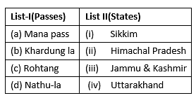
Match List-I with List-II :

Select the correct answer from the options given below:

Detailed Solution for TS SET Paper 2 Mock Test - 9 (Geography) - Question 30
  • The Mana pass derives from a name of a village with the same name in Uttarakhand. It’s last village on the border of Uttarakhand. Trade here is carried out with the help of mules.
  • Khardung la is a pass in Jammu & Kashmir. At 18000 ft above the sea level, it’s the highest motor able road in the world.
  • The famous Rohtang pass in Himachal Pradesh connects the Kullu Valley with Spiti and Lahual Valley.
  • Nathu la is a pass in Sikkim that lies in East Sikkim district and serves as one of the open trading posts on the border with China.

Thus, the correct answer is B.

View more questions
60 tests
Information about TS SET Paper 2 Mock Test - 9 (Geography) Page
In this test you can find the Exam questions for TS SET Paper 2 Mock Test - 9 (Geography) solved & explained in the simplest way possible. Besides giving Questions and answers for TS SET Paper 2 Mock Test - 9 (Geography), EduRev gives you an ample number of Online tests for practice
Download as PDF