Software Development Exam  >  Software Development Tests  >  Test: Bihar Specific (Physiographic Division of Bihar) - Software Development MCQ

Test: Bihar Specific (Physiographic Division of Bihar) - Software Development MCQ


Test Description

10 Questions MCQ Test - Test: Bihar Specific (Physiographic Division of Bihar)

Test: Bihar Specific (Physiographic Division of Bihar) for Software Development 2025 is part of Software Development preparation. The Test: Bihar Specific (Physiographic Division of Bihar) questions and answers have been prepared according to the Software Development exam syllabus.The Test: Bihar Specific (Physiographic Division of Bihar) MCQs are made for Software Development 2025 Exam. Find important definitions, questions, notes, meanings, examples, exercises, MCQs and online tests for Test: Bihar Specific (Physiographic Division of Bihar) below.
Solutions of Test: Bihar Specific (Physiographic Division of Bihar) questions in English are available as part of our course for Software Development & Test: Bihar Specific (Physiographic Division of Bihar) solutions in Hindi for Software Development course. Download more important topics, notes, lectures and mock test series for Software Development Exam by signing up for free. Attempt Test: Bihar Specific (Physiographic Division of Bihar) | 10 questions in 20 minutes | Mock test for Software Development preparation | Free important questions MCQ to study for Software Development Exam | Download free PDF with solutions
Test: Bihar Specific (Physiographic Division of Bihar) - Question 1

Which of the following is known as the Sorrow of Bihar?

Detailed Solution for Test: Bihar Specific (Physiographic Division of Bihar) - Question 1

The correct answer is Kosi.

  • Kosi is known as the ‘sorrow of Bihar’.
  • Kosi is also known as 'Saptakoshi' for its seven upper tributaries.
  • It enters the Territory of India near Hanuman Nagar in Nepal and joins the Ganga River near Kursela in the Kathihar district.
  • Ghaghra: It is also known as Saryu. It originates in Nepal. 
  • Kamla: Kamla barrage has been constructed on this river. 
  • Mahananda: It originates in Sikkim. Mahananda joins Ganga at Nawabganj in Bangladesh. 
Test: Bihar Specific (Physiographic Division of Bihar) - Question 2

Which is not part of physiological division of Bihar?

Detailed Solution for Test: Bihar Specific (Physiographic Division of Bihar) - Question 2

The correct answer is Aravali Range

Physiographical division of Bihar:
It is mainly divided into three physiographic units. The division is made based on physical and structural conditions: 
  • Shiwalik range: Shiwalik range shadows Bihar from the Northern part of West Champaran district over an area 32 km long and 6-8 km wide and it is further sub-divided into three parts based on variation:
    • Ramanagar doon
    • Somehwar range 
    • Harha valley
  • Bihar plain: Bihar plain is located between Northern Mountains and Southern Plateau region which is bounded by a 150m contour line in the North as well as in the South.
  • Southern plateau region:  Southern plateau region is located between Kaimur districts in the West to Banka in the East. This is made up of hard rocks such as gneiss, schist, and granite. The southern plateau region is blessed with many conical hills that are made up of batholim like Pretshil, Ramshila, and Jethian hill.
Test: Bihar Specific (Physiographic Division of Bihar) - Question 3

Which of the following statements is true about the Kosi Multipurpose Project -
I. This is a joint project between India and Nepal.
II. The main objective of this project is flood control, irrigation, and land conservation.
III. This project is mainly divided into 3 parts

Detailed Solution for Test: Bihar Specific (Physiographic Division of Bihar) - Question 3

Option 1 is correct,

Kosi multipurpose project is related to the Bihar state. The dam will be built on Saptkoshi river of Nepal.

  • Kosi Multipurpose Project-
    • It is a joint water project of the Government of India and Nepal.
    • It was built in 1954 by the Government of India and the Government of Nepal under an agreement that was revised again in 1961.
  • The main objective of this project - flood control, irrigation, hydropower generation, and land conservation, etc.
  • This project is mainly divided into 2 parts
  1. East Kosi Canal System 
  • With this canal system, irrigation is done in the districts of Madhepura, Saharsa, Purnia, Katihar, etc. in Bihar.
    • Its total length is 44km.
  1. Western Kosi Canal System 
  • With this canal system, irrigation is done in the districts of Madhubani, Darbhanga, Muzaffarpur, etc. in Bihar.
  • Its total length is 115km.
Test: Bihar Specific (Physiographic Division of Bihar) - Question 4
Which of the following is the hills of Bihar?
Detailed Solution for Test: Bihar Specific (Physiographic Division of Bihar) - Question 4

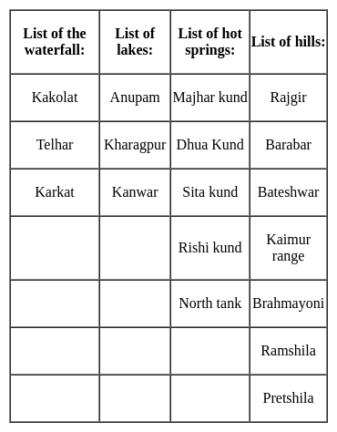
The correct answer is All of the above.

Key Points

Test: Bihar Specific (Physiographic Division of Bihar) - Question 5
Which of the following statements is true about the Tamasin Falls -
I. This waterfall is on the river Mahane
II. The height of this waterfall is about 50 feet
III. This waterfall is located on the border of Bihar and Jharkhand
Detailed Solution for Test: Bihar Specific (Physiographic Division of Bihar) - Question 5

Option 4 is correct,

  • The river falling from the rocks of the mountains is called the waterfall.
  • Major waterfalls in Bihar, their elevation (in feet), river and their position-

Note-

Durgavati River-

  • It flows through the Kaimur district of Bihar.
  • It is a tributary of the Karmnasha River.
Test: Bihar Specific (Physiographic Division of Bihar) - Question 6
Which of the following waterway passes through Bihar?
Detailed Solution for Test: Bihar Specific (Physiographic Division of Bihar) - Question 6

The correct answer is all of the above.

  • National Waterway 1 (NW-1) which connects Allahabad to Haldia Passes through Bihar.
  • Whereas the newly declared National Waterway – 37 (Gandak River) and National Waterway – 58 (Kosi river) are predominantly situated in Bihar with only a part of Gandak waterway proposed in Uttar Pradesh.

Key Points

  • National Waterway-1, declared a national waterway in 1986, is planned on Ganga –Bhagirathi and Hooghly river system and passes through the states of Uttar Pradesh, Bihar, Jharkhand, and West Bengal. 
  • A new surge in the developmental interventions in the rivers in India is seen with the implementation of the National Inland Waterways Act, 2016.
  • Under this Act, 138 stretches of the rivers, creeks, backwaters, estuaries, etc. in 24 states and 2 union territories will be developed as the ‘national inland waterways’ for the transportation of huge cargo and passenger vessels.
  • The development of these waterways will be controlled and regulated by the Inland Waterways Authority of India (IWAI). 

Important Points

  • Seven of the rivers of Bihar – Ganga, Gandak, Ghaghra, Kosi, Karamnasa, Sone, and Punpun are amongst the 111 declared national waterways of India.
  • The waterways planned on Ganga, Gandak, and Kosi rivers in Bihar are of specific strategic importance as these waterways are amongst the 37 waterways which have been prioritized for development by 2019.
  • The recent joint announcement by the Governments of India and Nepal has declared that Kosi and Gandak would be developed as international Indo-Nepal waterways, to provide sea connectivity to Nepal.

Additional Information

  • Streamer services are available at Bararighat near Bhagalpur.
  • In order to prevent boat accidents in Bihar, Model Boat Rules, 2011 have been framed under the Bengal Ferries Act, 1885.
  • Under which norms for crew members have been prescribed.
  • Under the Bihar Inland Water Vessels Rules, 2013 the inland vessels will get surveyed and registered in Bihar itself.
  • The National Inland Navigation Institute (NINI), Patna will conduct an exam, and the state government will issue a certificate of competency to the vessels staffs.
Test: Bihar Specific (Physiographic Division of Bihar) - Question 7
Which of the following statements is true -
I. Shivhar is a district with minimum forest area of Bihar.
II. Kaimur is the most forested district of Bihar
Detailed Solution for Test: Bihar Specific (Physiographic Division of Bihar) - Question 7

Option 3 is correct,

  • Districts with the highest forest area in Bihar - Kaimur and West Champaran.
  • Districts of minimum forest area in Bihar - Shivar and Sheikhpura.

NOTE

  • The total geographical area of Bihar - 94,163sq km.
  • Total forest area - 7288sq km.
  • Percentage of the total area of Bihar 7.74%
  • Highly compacted forest area - 248 sq km.
  • Protected forest area in the state- 3208.47sq km.
  • Non-protected forest area in the state - 76.3 sq km.
  • There are 2 types of forests found in Bihar -
    • Wet wood forest-
      • These forests are found in such places where the annual rainfall is more than 120 CM.
      • The major trees of this forest are - shisham, Shalem, shawl, khair.
    • Dry deciduous forest-
      • These forests are found in such places where the annual rainfall is less than 120 CM.
      • The major trees of this forest are Mahua, Mango, Jackfruit.
Test: Bihar Specific (Physiographic Division of Bihar) - Question 8
Which of the following irrigation projects is related to Bihar -
I. Punpun barrage scheme
II. North Koel Reservoir Scheme
III. Zamania Pump Canal Scheme
IV. Tilaiya diversion reservoir scheme
Detailed Solution for Test: Bihar Specific (Physiographic Division of Bihar) - Question 8

Option 4 is correct,

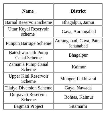
Latest irrigation projects of Bihar and related districts -

Test: Bihar Specific (Physiographic Division of Bihar) - Question 9
Which of the following districts of Bihar is irrigated by the western Kosi canal system?
I.  Madhubani
II. Darbhanga
III. Muzaffarpur
IV. Sarhasa
V. Purnia
Detailed Solution for Test: Bihar Specific (Physiographic Division of Bihar) - Question 9

Option 1 is correct,

 Key Points

  • Kosi multipurpose project is related to the Bihar state.
  • Kosi Multipurpose Project-
    • It is a joint water project of the Government of India and Nepal.
    • It was built in 1954 by the Government of India and the Government of Nepal under an agreement that was revised again in 1961.
  • The main objective of this project - flood control, irrigation, hydropower generation, and land conservation, etc.
  • This project is mainly divided into 2 parts -
  1. East Kosi Canal System -
    • With this canal system, irrigation is done in the districts of Madhepura, Saharsa, Purnia, Katihar, etc. in Bihar.
    • Its total length is 44km.
  2. Western Kosi Canal System -
    • With this canal system, irrigation is done in the districts of Madhubani, Darbhanga, Muzaffarpur, etc. in Bihar.
    • Its total length is 115km.
Test: Bihar Specific (Physiographic Division of Bihar) - Question 10
Which of the following district of Bihar is listed among the gold mineral producing places? 
Detailed Solution for Test: Bihar Specific (Physiographic Division of Bihar) - Question 10

The correct answer is Jamui.

Key Points

  • Gold reserve in Bihar 
    • Gold is a precious mineral used as an ornament and international currency. Also used in dentistry and carving.
    • Gold deposits are in Gaya, Nalanda and Jamui districts.
    • As per National Mineral Inventory, the total resources of primary gold ore in the country as of 1.4.2015 are estimated at 501.83 million tonnes with 654.74 tonnes of gold metal and out of this, Bihar is endowed with 222.885 million tonnes (44%) of ore containing 37.6 tonnes of metal.
    • The Indian Geological Survey [GSI] confirmed gold deposits in the Kabutra and Nakia hill regions of Rajgir and Karmatia, Rani hill, Badmaria, Marhi hill in Sono block in Jamui district.
Information about Test: Bihar Specific (Physiographic Division of Bihar) Page
In this test you can find the Exam questions for Test: Bihar Specific (Physiographic Division of Bihar) solved & explained in the simplest way possible. Besides giving Questions and answers for Test: Bihar Specific (Physiographic Division of Bihar), EduRev gives you an ample number of Online tests for practice
Download as PDF