Software Development Exam  >  Software Development Tests  >  Test: Bihar Specific (Rivers and Water Resources of Bihar) - Software Development MCQ

Test: Bihar Specific (Rivers and Water Resources of Bihar) - Software Development MCQ


Test Description

10 Questions MCQ Test - Test: Bihar Specific (Rivers and Water Resources of Bihar)

Test: Bihar Specific (Rivers and Water Resources of Bihar) for Software Development 2025 is part of Software Development preparation. The Test: Bihar Specific (Rivers and Water Resources of Bihar) questions and answers have been prepared according to the Software Development exam syllabus.The Test: Bihar Specific (Rivers and Water Resources of Bihar) MCQs are made for Software Development 2025 Exam. Find important definitions, questions, notes, meanings, examples, exercises, MCQs and online tests for Test: Bihar Specific (Rivers and Water Resources of Bihar) below.
Solutions of Test: Bihar Specific (Rivers and Water Resources of Bihar) questions in English are available as part of our course for Software Development & Test: Bihar Specific (Rivers and Water Resources of Bihar) solutions in Hindi for Software Development course. Download more important topics, notes, lectures and mock test series for Software Development Exam by signing up for free. Attempt Test: Bihar Specific (Rivers and Water Resources of Bihar) | 10 questions in 20 minutes | Mock test for Software Development preparation | Free important questions MCQ to study for Software Development Exam | Download free PDF with solutions
Test: Bihar Specific (Rivers and Water Resources of Bihar) - Question 1

Ganga river passes through How many districts in Bihar?

Detailed Solution for Test: Bihar Specific (Rivers and Water Resources of Bihar) - Question 1

The correct answer is 12

Key Points

  • The number of districts situated on the bank of the Ganga river in Bihar State is 12.
  • These districts are Buxar, Bhojpur, Saran, Patna, Vaishali, Samastipur, Begusarai, Munger, Khagaria, Katihar, Bhagalpur, Lakhisarai.
  • Ganga River:

  • The Ganga rises from the Gangotri glacier near Gomukh in the Uttarkashi district of the state of Uttarakhand.
  • The total length of the Ganga is about 2,525 km.
  • The river is bounded by the Himalayas on the north, by the Aravalli on the west, by the Vindhyas and Chhotanagpur plateau on the south, and by the Brahmaputra Ridge on the east.
  • Left Tributaries: Karnali, Mahakali, Gandak, Kosi Ramganga, Ghagra,Mahananda etc.
  • Right Tributaries: Yamuna, Son, Damodar, Ken.
Test: Bihar Specific (Rivers and Water Resources of Bihar) - Question 2

Which of the following statements is not true about the Sukhlhari Falls of Bihar -
I. This waterfall is on the river Mahane
II. The height of this waterfall is about 100 feet
III. This waterfall is located on the border of Bihar and Uttar Pradesh

Detailed Solution for Test: Bihar Specific (Rivers and Water Resources of Bihar) - Question 2

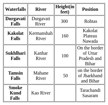
Option 3 is correct,

  • The river falling from the rocks of the mountains is called the waterfall.
  • Major waterfalls in Bihar, their elevation (in feet), river and their position-

Note-

Durgavati River-

  • It flows through the Kaimur district of Bihar.
  • It is a tributary of the Karmnasha River.
Test: Bihar Specific (Rivers and Water Resources of Bihar) - Question 3

Kabartal Wetland was designated as a Ramsar site in 2020. In which of the following states is it located?

Detailed Solution for Test: Bihar Specific (Rivers and Water Resources of Bihar) - Question 3

The correct answer is Bihar.

Key Points

  • Kabartal Wetland in Bihar was designated as a Ramsar site in 2020
    • The Site is one of 18 wetlands within an extensive floodplain complex.
    • This absorption of floodwaters is a vital service in Bihar State where 70% of the land is vulnerable to inundation.
    • During the dry season, areas of marshland dry out and are used for agriculture.
    • Significant biodiversity is present, with 165 plant species and 394 animal species recorded, including 221 bird species.
    • The Wetland is an important stopover along the Central Asian Flyway, with 58 migratory waterbirds using it to rest and refuel.

Additional Information

  • Ramsar Convention on Wetlands is an international treaty for “the conservation and sustainable use of wetlands”.
    • It is also known as the Convention on Wetlands and is named after the city of Ramsar in Iran.
    • The treaty was established in 1971 by UNESCO and came to force in 1975.
Test: Bihar Specific (Rivers and Water Resources of Bihar) - Question 4
In which of the following districts river Ganga enters into Bihar?
Detailed Solution for Test: Bihar Specific (Rivers and Water Resources of Bihar) - Question 4

The correct answer is Buxar​. 

Key Points

  • Ganga is the main river in Bihar that enters in the boundary of Bihar at Chausa, near Buxar after its confluence with Karmanasa.
  • Tributaries of Ganga includes - Gandak, Bagmati, Punpun, Sone, Karmanasa, Kosi, Kali.
  • Gandhi Setu was built over this river to connect North Bihar with the rest of Bihar.
  • River Ganga divides Bihar into two unequal parts North Bihar and South Bihar.
  • In Patna, the length of the River Ganga is maximum i.e 99 km.

Additional Information

  • About River Ganga
    • Ganga is a transboundary river in Asia.
    • It flows through India and Bangladesh
    • It originates in the western Himalayas in the state of Uttarakhand.
    • Ganga empties into the Bay of Bengal.
    • Its total length is 2,525 km.
    • It is the third-largest river on Earth by discharge.
Test: Bihar Specific (Rivers and Water Resources of Bihar) - Question 5
Which of the following lakes is situated in Bihar?
Detailed Solution for Test: Bihar Specific (Rivers and Water Resources of Bihar) - Question 5

The correct answer is Anupam Lake.

Key Points

  • Anupam Lake:
    • It is situated in the Kaimur Wildlife Sanctuary.
    • Kaimur Wildlife Sanctuary is situated in the Kaimur district of Bihar, near the town of Bhabhua.
    • It is the largest sanctuary in the state and covers an area of about 1,342 km2 (518 sq mi).
    • The government of Bihar has planned to construct it into Tiger Reserve.
    • There are three well-defined seasons: the hot-weather season, lasting from March to mid-June; the season of southwest monsoon rains, from mid-June to October; and the cold-weather season, from November to February.

Additional Information

  • Other Lakes and their locations:
  • Sambhar Lake - Jaipur, Rajasthan
  • Sukhna Lake - Chandigarh
  • Kama Lake - Russia
Test: Bihar Specific (Rivers and Water Resources of Bihar) - Question 6
In which district is the famous waterfall 'Kakolat' of Bihar located?
Detailed Solution for Test: Bihar Specific (Rivers and Water Resources of Bihar) - Question 6

The correct answer is Nawada.

  • Kakolat waterfall located in the Nawada district of Bihar, India.

Key Points

  • The Kakolat waterfall of Bihar cascades down from a height of between 150 and 160 feet and forms a natural reservoir at the base of the waterfall.
  • Legends are also associated with the Kakolat waterfall such as a Treta Yuga king who was cursed to take the shape of a python and live at the falls here, by a Hindu spiritualist. 
  • The place was then visited by the Pandavas during their exile and it was during that time that the python king got rid of the curse, and he proclaimed that any person who bathed in the waterfall would never be reborn as a snake.
Test: Bihar Specific (Rivers and Water Resources of Bihar) - Question 7
Which of the rivers flowing from Bihar has its origin in Amarkantak?
Detailed Solution for Test: Bihar Specific (Rivers and Water Resources of Bihar) - Question 7

The correct answer is Son.

  • Son River of central India is the second largest of the Ganges' southern tributaries after the Yamuna River.
  • Son River is a multi-state river which flows through Madhya Pradesh, Uttar Pradesh, Chhattisgarh, Bihar, and Jharkhand.
  • It originates from the Amarkantak region of Madhya Pradesh and flows up to Bihar and gets merged into Ganga.

Important Points

  • After starting its flow from Madhya Pradesh, it flows to the north in the Manpur area, and then it turns north-east before entering Bihar.
  • After entering Bihar, the Son River encounters the southwest-northeast of Kaimur range and then it joins the Ganga River in Patna after traveling 784 km course.
  • The coverage area system of Son River is surrounded by the Vindhyachal range in the north, Pun Pun River, and Chhota Nagpur plateau in the east.
  • From the southern side, Son River is surrounded by the Baghelkhand plateau, and the Mahadeva hills and forests of Maikal and Bhamver range from the western side.
  • Dehri on Sone and Sonbhadra are the major cities that are situated near Son River.
  • The first dam on Son River was built in 1873-74 at Dehri.

Famous bridges that are built on Son River are:

  • Abdul Bari Bridge near Arrah.
  • Nehru Setu at Dehri.

The chief tributaries of Son River are:

  • Rihand River
  • North Koel River
  • Kanhar

Additional Information

  • The famous cities like Dehri on Sone and Sonbhadra are situated on the banks of Son River and the Kabra Khurd is also located on the river's bank.
  • The flow of Son River is seasonal so, it is unsuitable for navigation.
Test: Bihar Specific (Rivers and Water Resources of Bihar) - Question 8
Barnal Reservoir Scheme is related to which district of which state of India?
Detailed Solution for Test: Bihar Specific (Rivers and Water Resources of Bihar) - Question 8

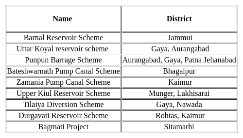
Option 3 is correct,

Latest irrigation projects of Bihar and related districts -

Test: Bihar Specific (Rivers and Water Resources of Bihar) - Question 9

Karkat waterfall is located in Which of the following states?

Detailed Solution for Test: Bihar Specific (Rivers and Water Resources of Bihar) - Question 9

The correct answer is option 4 i.e None of these

Key Points

  • Karkat waterfalls are located near Kaimur hills in the Kaimur district, Bihar.
  • It is located near the Kaimur Wildlife Sanctuary which is the largest wildlife habitat in Bihar,
  • Other famous waterfalls in Bihar are: Kakolat Waterfall, Telhar Waterfall, etc.

Bihar:

  • Capital: Patna
  • CM: Nitish Kumar
  • Governor: Rajendra Arlekar
Test: Bihar Specific (Rivers and Water Resources of Bihar) - Question 10
In Bihar, the rivers belonging to which one of the following groups join the Ganga or its tributaries flowing from the North? 
Detailed Solution for Test: Bihar Specific (Rivers and Water Resources of Bihar) - Question 10

The correct answer is Gandak, Kamla, Bhagmati

Key Points

 ​Ganga River System

  • The Ganges River originates in the Himalayan Mountains at Gomukh, the terminus of the Gangotri. When the ice of this glacier melts, it forms the clear waters of the Bhagirathi River. 
  •  As the Bhagirathi River flows down the Himalayas, it joins the Alaknanda River, officially forming the Ganges River.
  • The Ganges flows south and east from the Himalayas, forming a canyon as it leaves the mountain. It winds its way through northern India, eventually emptying into the Bay of Bengal. 
  • As the river empties into the Bay of Bengal, the mouth forms the Ganges River Delta, the largest river delta in the world.
  • Haridwar, Kanpur, Soron, Kannauj, Allahabad, Varanasi, Patna, Ghazipur, Bhagalpur, Mirzapur, Ballia, Buxar, Saidpur, and Chunar are the important towns.
  • Left Tributaries of Ganga
    • Ramganga, Gomti, Ghaghra, Gandak, Koshi, and Mahananda
  • Right Tributaries of Ganga
    • Yamuna, Tons, Karmnasa, Punpun, Damodar, and Rupnarayan

Important Points

  • Gandak
    • It is formed by the union of the Kali and Trisuli rivers, which rise in the Great Himalayan Range in Nepal.
    • From this junction to the Indian border the river is called the Narayani.
    • It enters the Ganga river opposite Patna in a place called Sonepur after a winding course of 765 km.
    • The upper catchment area of the river is bleak and desolate lying in the rain shadow area of the Himalayan range.
    • The river's middle and lower courses flow through the V-shaped valleys, incised meanders, and have paired and unpaired terraces on either side.
  • Kosi
    • Saptakoshi for its 7 Himalayan tributaries, it is an antecedent transboundary river flowing through Nepal and India.
    • Some of the rivers of the Kosi system, such as the Arun, the Sun Kosi, and the Bhote Koshi, originating in Tibet.
    • This 729km long river is one of the largest tributaries of the Ganga and joins it at Kursela in the Kathiar district.
    • The highest peak in the world, Mt.Everest and Kanchenjunga are in the Kosi catchment.
    • Bagmati is a major tributary of the Kosi.
    • Its unstable nature has been attributed to the heavy silt it carries during the monsoon season, Due to this, it is also termed as “The Sorrow of Bihar”.
  • Son
    • The Son, 784km long, originates near Amarkantak in MP, just east of the headwater of the Narmada River, and flows north-northwest through MP before turning sharply eastward where it encounters the southwest-northeast running Kaimur Range.
    • The Son parallels the Kaimur hills, flowing east-northeast through UP, Jharkhand, and Bihar states to join the Ganga just above Patna.
    • Its major tributaries are the Rihand and the North Koel
Information about Test: Bihar Specific (Rivers and Water Resources of Bihar) Page
In this test you can find the Exam questions for Test: Bihar Specific (Rivers and Water Resources of Bihar) solved & explained in the simplest way possible. Besides giving Questions and answers for Test: Bihar Specific (Rivers and Water Resources of Bihar), EduRev gives you an ample number of Online tests for practice
Download as PDF