Software Development Exam  >  Software Development Tests  >  Test: General Awareness (Indian Geography) - Software Development MCQ

Test: General Awareness (Indian Geography) - Software Development MCQ


Test Description

10 Questions MCQ Test - Test: General Awareness (Indian Geography)

Test: General Awareness (Indian Geography) for Software Development 2025 is part of Software Development preparation. The Test: General Awareness (Indian Geography) questions and answers have been prepared according to the Software Development exam syllabus.The Test: General Awareness (Indian Geography) MCQs are made for Software Development 2025 Exam. Find important definitions, questions, notes, meanings, examples, exercises, MCQs and online tests for Test: General Awareness (Indian Geography) below.
Solutions of Test: General Awareness (Indian Geography) questions in English are available as part of our course for Software Development & Test: General Awareness (Indian Geography) solutions in Hindi for Software Development course. Download more important topics, notes, lectures and mock test series for Software Development Exam by signing up for free. Attempt Test: General Awareness (Indian Geography) | 10 questions in 10 minutes | Mock test for Software Development preparation | Free important questions MCQ to study for Software Development Exam | Download free PDF with solutions
Test: General Awareness (Indian Geography) - Question 1

Which of the following crops is an example of Kharif Crops ?

Detailed Solution for Test: General Awareness (Indian Geography) - Question 1

The correct answer is Cotton.

Key Points

  • Cotton is a Kharif crop. It requires 6 to 8 months to mature.
  • Cotton is a water-thirsty crop and around 6% of the water for irrigation in is used for its cultivation. 
  • It grows in the major parts of the country viz. Punjab, Haryana, Rajasthan, Uttar Pradesh, Madhya Pradesh, Gujarat, Maharashtra and parts of Andhra Pradesh & Karnataka.
  • The irrigated crop is sown from March-May and the rain fed crop in June-July with the commencement of the monsoon.
  • Kharif Season:
    • Kharif crops also are known as monsoon crops as they are cultivated in the monsoon season.
    • These crops are sown at the beginning of the rainy season.
    • Rice, maize, bajra, ragi, sorghum, soybean, groundnut, cotton, etc. are all Kharif types of crops.

Additional Information

  • Zaid Season:
    • It is a short season between Kharif and Rabi season.
    • The crops grown during this season are known as Zaid crops.
    • Pumpkin, cucumber, watermelon, bitter gourd, etc. are all zaid types of crops. 
  • Rabi Season:
    • These are the crops that are sown at the end of the monsoon season or at the beginning of the winter season.
    • These crops also are known as winter crops.
    • Wheat, Mustard, Peas, Pulses, Barley, etc. are all Rabi types of crops.
Test: General Awareness (Indian Geography) - Question 2

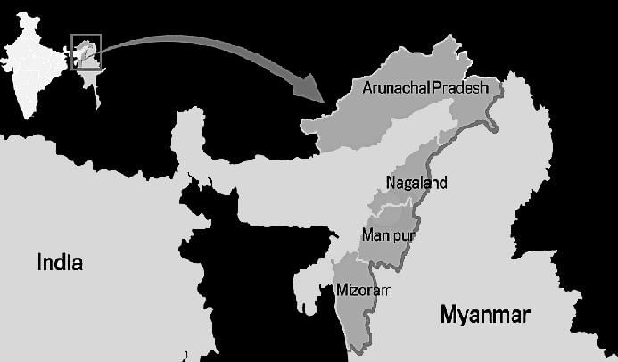
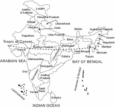
Which state does not share its boundary with Myanmar ?

Detailed Solution for Test: General Awareness (Indian Geography) - Question 2

The correct answer is Sikkim.

Key Points

  • Sikkim shares international boundaries with Bhutan, China, and Nepal.
  • Arunachal Pradesh, Nagaland, Manipur, and Mizoram share an international boundary with Myanmar.

Test: General Awareness (Indian Geography) - Question 3

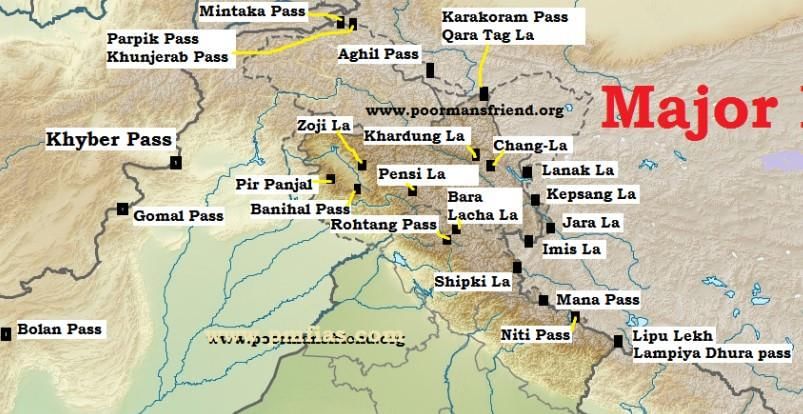
River Sutlej enters India through which pass?

Detailed Solution for Test: General Awareness (Indian Geography) - Question 3

The correct answer is Shipki la.

Key Points

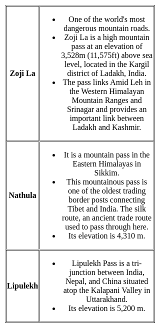
  • Shipki La is a mountain pass and border post on the India-Tibet border.
  • The river Sutlej enters India through this pass.
    • It is located in the Kinnaur district in the state of Himachal Pradesh, India, and Tibet.
  • This pass is India's third border post for trade with Tibet after Nathu La in Sikkim, and Lipulekh in Uttarakhand.

Important Points

Test: General Awareness (Indian Geography) - Question 4
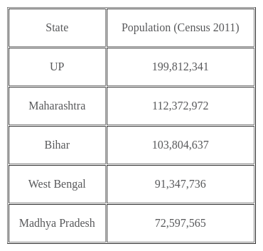
As per the 2011 Census, which of the following is the least populated state in India? 
Detailed Solution for Test: General Awareness (Indian Geography) - Question 4

The correct answer is Sikkim.

Key Points

  • Sikkim has a population of 6.11 Lakhs.
  • The Sikkim census of 2011 says the population of Sikkim is the least in all of India.
  • Prem Singh Tamang, better known as P. S. Golay, is an Indian politician and the current Chief Minister of Sikkim and leader and founder of the Sikkim Krantikari Morcha (SKM).
  • Governor of Sikkim: Lakshman Prasad Acharya (Dec 2023).

Additional Information

  • According to a 2011 census, in that year Mizoram's population was 1,091,014.
    • It is the 2nd least populous state in the country.
    • Lal Thanhawla is an Indian politician who is the Chief Minister of Mizoram.
  • As per details from Census 2011, Tripura has a population of 36.74 Lakhs.
    • Chief Minister: Manik Saha
    • Governor: Indrasena Reddy (As of 2023)
  • According to the 2011 Census of India, Uttarakhand has a population of 10,086,292.

Important Points

The highest population as per the 2011 census is observed in UP.

Test: General Awareness (Indian Geography) - Question 5

The Tropic of Cancer passes through how many states of India?

Detailed Solution for Test: General Awareness (Indian Geography) - Question 5

The correct answer is 8.

Key Points

  • The latitude approximately 23°27′ N of the terrestrial equator is called tropic of cancer.
  • There are 17 countries(Including Taiwan) through which the tropic of cancer passes.
  • The tropic of cancer is the only latitude pass through India.
  • The tropic of cancer passes through 8 Indian states.
  • The 8 Indian states through which tropic of cancer passes through are:
    1. Gujarat.
    2. Rajasthan.
    3. Madhya Pradesh.
    4. Chhatisgarh.
    5. Jharkhand.
    6. West Bengal.
    7. Tripura.
    8. Mizoram.

Important Points

  • Mahi River is the only river in India that cuts the Tropic of Cancer twice.
  • "Bhopal (capital of Madhya Pradesh)” and “Gandhinagar (capital of Gujarat)” is also located fairly close to the “Tropic of Cancer”.  
  • Tropic of Cancer passes through 17 countries, 3 Continents, 6 water bodies.

Test: General Awareness (Indian Geography) - Question 6
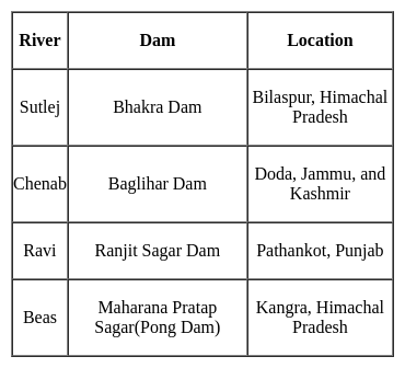
The Bhakra Nangal dam is situated on the ______ river.
Detailed Solution for Test: General Awareness (Indian Geography) - Question 6

The correct answer is Sutlej.

Test: General Awareness (Indian Geography) - Question 7
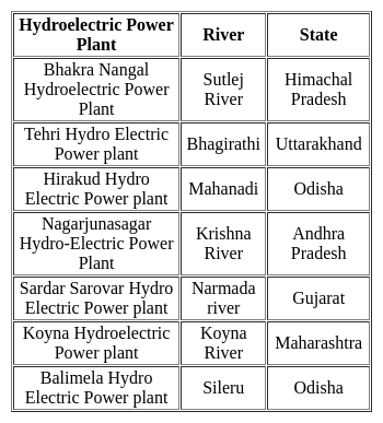
Srisailam Hydroelectric Power Plant is built on which river?
Detailed Solution for Test: General Awareness (Indian Geography) - Question 7

The correct answer is Krishna River.

Key Points

  • The Srisailam Dam is located in the Kurnool district of Andhra Pradesh.
  • Srisailam hydroelectric power project is constructed across the Krishna River.
  • The Srisailam project is the 12th largest capacity hydroelectric project in the country.
  • The 512 m long and 145 m high dam was constructed in a deep gorge.
  • The left bank hydroelectric power station generates 6 X 150 MW of power and the right bank generates 7 X 110 MW of power.
  • Srisailam dam forms the reservoir with a gross storage of 215 TMC ft.
  • The Srisailam hydroelectric power station is the third-largest construction project in India.

Important Points

  • The Koyna Hydroelectric Project is the largest completed hydroelectric plant in India.
  • Its power capacity is 1920 megawatts.
  • The first hydroelectric power station was the Shivanasamudra hydroelectric power station.
  • Tehri Hydro Power Plant is the tallest hydropower project in the country, and Terry Dam is also the tallest hydropower plant in India.
  • The Nathpa Jhakri Hydroelectric Power Plant is the largest underground hydroelectric project in the country.

Additional Information 

Test: General Awareness (Indian Geography) - Question 8
Saddle Peak' the highest peak of Andaman and Nicobar Islands is located in _________.
Detailed Solution for Test: General Awareness (Indian Geography) - Question 8
  • 'Saddle Peak' the highest peak of Andaman and Nicobar Islands is located in  Diglipur, a town in North Andaman Island.
  • It is the highest point of the archipelago in the Bay of Bengal with a length of 731 meters (2,418 feet) followed by Mount Thullier at 2,106 feet (642 meters) on Great Nicobar and Mount Harriet at 1,197 feet (365 meters) on South Andaman.
  • It is surrounded by Saddle Peak National Park.
Test: General Awareness (Indian Geography) - Question 9
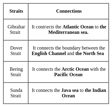
Which strait connects the Arctic Ocean with the Pacific Ocean?
Detailed Solution for Test: General Awareness (Indian Geography) - Question 9

The correct answer is Bering Strait.
Key Points

A Strait is a naturally formed, narrow, typically navigable waterway that connects two larger bodies of water.

Test: General Awareness (Indian Geography) - Question 10

Which among the following is the smallest wetland in India?

Detailed Solution for Test: General Awareness (Indian Geography) - Question 10

The correct answer is Renuka Wetland.

Key Points

  • Renuka Wetland in Himachal Pradesh is the smallest wetland in India.
  • It is in the Sirmaur district of Himachal Pradesh in India and it is 672 m above sea level.
  • It is a natural wetland with freshwater springs and inland subterranean karst formations, fed by a small stream flowing from the lower Himalayan out to the Giri river.
  • The lake is home to a variety of flora and fauna.
  • The site is managed by the Shimla Forest Department, Himachal Pradesh.

Additional Information

  • Any wetland site which has been listed under the Ramsar Convention that aims to conserve it and promote sustainable use of its natural resources is called a Ramsar Site.
  • Ramsar Convention is known as the Convention of Wetlands.
  • It was established in 1971 by UNESCO and came into force in 1975.
  • India is a party to the Ramsar Convention. India signed under it on 1st February 1982.
  • India has a network of 75 Ramsar sites (as of August 2022)
  • World Wetlands Day 2023 Theme - “It's Time for Wetlands Restoration,” which highlights the urgent need to prioritize wetland restoration.

Important Points

  • World Wetlands Day:
    • World Wetlands Day is celebrated every year on 2 February.  
    • The Theme of World Wetlands Day 2023 is “It's Time for Wetlands Restoration” 
    • This day marks the date of the adoption of the Convention on Wetlands on 2 February 1971, in the Iranian city of Ramsar on the shores of the Caspian Sea.
    • The first wetlands day was celebrated in 1997.
Information about Test: General Awareness (Indian Geography) Page
In this test you can find the Exam questions for Test: General Awareness (Indian Geography) solved & explained in the simplest way possible. Besides giving Questions and answers for Test: General Awareness (Indian Geography), EduRev gives you an ample number of Online tests for practice
Download as PDF