Software Development Exam  >  Software Development Tests  >  Test: Geography - II - Software Development MCQ

Test: Geography - II - Software Development MCQ


Test Description

20 Questions MCQ Test - Test: Geography - II

Test: Geography - II for Software Development 2025 is part of Software Development preparation. The Test: Geography - II questions and answers have been prepared according to the Software Development exam syllabus.The Test: Geography - II MCQs are made for Software Development 2025 Exam. Find important definitions, questions, notes, meanings, examples, exercises, MCQs and online tests for Test: Geography - II below.
Solutions of Test: Geography - II questions in English are available as part of our course for Software Development & Test: Geography - II solutions in Hindi for Software Development course. Download more important topics, notes, lectures and mock test series for Software Development Exam by signing up for free. Attempt Test: Geography - II | 20 questions in 20 minutes | Mock test for Software Development preparation | Free important questions MCQ to study for Software Development Exam | Download free PDF with solutions
Test: Geography - II - Question 1

How much percentage of the Haryana population is engaged in agriculture?

Detailed Solution for Test: Geography - II - Question 1

The correct answer is 70.

Key Points

  • The major crops of the state are wheat and rice.
  • Haryana is the second largest contributor to India’s central pool of food grains.
  • When the green revolution started in India in 1970, Haryana contributed significantly.
Test: Geography - II - Question 2

Samalkha subdivision of the Panipat district is famous for the foundry of which instruments? 

Detailed Solution for Test: Geography - II - Question 2

The correct answer is Agricultural products.

  • Panipat district is a part of the Karnal Lok Sabha Constituency.
  • There are four Vidhan Sabha constituencies in the Panipat district i.e Panipat Rural, Panipat City, Israna, Samalkha.
  • Panipat district is situated on Shershah Suri Marg (now known as G.T. road or NH-1), 90 KM north of Delhi.
  • On three sides, Panipat district boundaries touch other districts of Haryana, Karnal in the north, Jind in the west, and Sonipat in the south.
  • Panipat was a part of the Karnal district until 31 October 1989.
  • It was separated from Karnal, along with another subdivision, the Assandh tehsil. When the district was re-formed on 1 January 1992, the Assandh tehsil was excluded.
  • In 2011, Panipat had a population of 1,202,811 of which males and females were 646,324 and 556,487 respectively.
  • The urban population percentage in Panipat district was 45.97% and the rural population in the district was 54.03% according to the 2011 census.
  • The sex ratio in urban and rural areas of district Panipat was 864 and 858 respectively.
  • Panipat District population constituted 4.74 percent of the total Haryana population.
  • Panipat district has an area of around 1268 square kilometres.
  • The literacy rate of the Panipat district is 75.94%.
  • Panipat is a city of textiles and carpets. It is the biggest centre for quality blankets and carpets in India and has a handloom weaving industry.
  • The Samalkha subdivision of this district is famous for the Foundry of Agriculture instruments.
  •  Panipat city is the biggest center of “Shoddy Yarn” in the World.
  • There are five tehsils in district Panipat i.e Bapoli, Israna, Madlauda, Panipat, and Samalkha.
  • There are two municipalities in the district Panipat that are Municipal Committee Samalkha, Municipal Corporation Panipat.

About Haryana

  • Capital - Chandigarh
  • Chief Minister - Manohar Lal Khattar
  • Governor - Bandaru Dattacharya
Test: Geography - II - Question 3

Munak canal which was situated in Haryana originates from which district of Haryana?

Detailed Solution for Test: Geography - II - Question 3

The correct answer is Karnal.

  • Munak canal which was situated in Haryana originates from the Karnal district of Haryana.
  • It was built in 1819 and renovated in the year 2008.
  • It extends towards Delhi from the Karnal in Haryana and passes through the Jhajjar district.
  • It carries 700 cusecs of water towards Delhi, its water is used for drinking water supply in Delhi.

About Haryana

  • Capital - Chandigarh
  • 1st Chief Minister - Bhagwat Dayal Sharma (Indian National Congress)
  • 1st Governor - Dharma Vira
Test: Geography - II - Question 4
Bhakra canal has been drawn from which River near Nangal?
Detailed Solution for Test: Geography - II - Question 4

The correct answer is Satluj.

  • Bhakra canal has been drawn from the Satluj River near Nangal.

Key Points

  • It’s a concrete gravity dam located in Bilaspur, Himachal Pradesh.
  • Govind Sagar reservoir is formed by the dam.
  • The length of the dam is 518.25 m and the width of the dam is 9.1 m.
  • The reservoir of the dam is known as Govind Sagar.
  • Bhakra dam has created a 90 km long reservoir.
  • Pandit Jawaharlal Nehru described the dam as the “New temple of resurgent India”.
Test: Geography - II - Question 5
Rajiv Gandhi Thermal Power Plant a mega project in the field of electicity is situated in __________ .
Detailed Solution for Test: Geography - II - Question 5

The correct answer is Hisar.

Key Points

  • Rajiv Gandhi Thermal Power Station is located at Khedar in the Hisar district of Haryana.
  • It is a coal-based Power plant of the Haryana Power Generation Corporation Limited (HPGCL).
  • The plant gets coal from the Mahanadi coalfield Odisha.
  • It is the first mega power project of Haryana.
Test: Geography - II - Question 6
KMP Western Peripheral Expressway passes through how many districts of Haryana?
Detailed Solution for Test: Geography - II - Question 6

The correct answer is 5.

  • Kundli-Manesar-Palwal (KMP) Western Peripheral Expressway is the six-lane expressway passes through five districts in Haryana i.e Sonipat, Jhajjar, Gurugram, Mewat, and Palwal.
  • It will be connecting to four major highways i.e Delhi-Ambala-Amritsar, Delhi-Agra-Varanasi-Dankuni, Delhi-Jaipur-Ahmedabad-Mumbai, and the Delhi-Hisar-Fazilka-India-Pakistan border.
  • The expressway will provide an alternative route to vehicles, especially heavy vehicles to go towards Uttar Pradesh and Rajasthan through the national capital.
  • The total length of the expressway is approx. 135kms.
Test: Geography - II - Question 7
Bir Bara Ban Wildlife Sanctuary is situated in which district of Haryana?
Detailed Solution for Test: Geography - II - Question 7

The correct answer is Jind.

  • Bir Bara Ban Wildlife Sanctuary is in the Jind district of Haryana.
  • It was changed to a Sanctuary in October 2007.
  • About Jind - 
    • It is one of the 7 districts which were constituted with the establishment of Haryana.
    • It shares its border with 7 districts of Haryana namely Fatehabad, Hisar, Rohtak, Sonipat, Panipat, Karnal and Kaithal.
    • It also shares a border with Sangrur district of Punjab.
    • It was founded by Sikh King Raja Gajpat Singh in 1766.
    • According to the 2011 census, the 
      • Total population is 1,334,152.
      • Sex ratio is 871.
      • The literacy rate is 71.4%.
      • The population density is 494.
Test: Geography - II - Question 8
Deenbandhu Chhotu Ram Thermal Power Plant, is located in which district of Haryana?
Detailed Solution for Test: Geography - II - Question 8

The correct answer is Yamunanagar.

  • Deenbandhu Chhotu Ram Thermal Power Plant is located in the Yamunanagar district of Haryana.
  • It has a total installed capacity of 2x300 MW.
  • It spreads in the area of 1107 acres.
  • It is the first Power Project in the State Haryana to be awarded to Private Developer i.e. M/s Reliance Energy Ltd.
  • It is the first Project in the Country where BTG equipment was supplied by M/s Shanghai Electric Corp. China.
  • The first Unit of the plant was commissioned in a record period of 27 months which is the lowest for any coal-based greenfield project in the Country.
  • The Source of coal for the generation of power in the thermal power plant is from Central coalfields.

Test: Geography - II - Question 9
Which among the following is the first civil airport of Haryana?
Detailed Solution for Test: Geography - II - Question 9

The correct answer is Hisar Airport.

  • Hisar Airport is the first civil Airport of Haryana.
  • Airports in Haryana are:
    • Ambala Air Force Station
    • Bhiwani Airport
    • Bhilwara Airport
    • Hisar Airport
    • Kalka Airport
    • Karnal Airport
    • Sirsa Air Force Station
  • About Hisar:
    • It is the second-largest district of Haryana.
    • It is one of the 7 districts which was constituted with the establishment of Haryana.
    • It shares borders with Fatehabad, Jind, Rohtak and Bhiwani districts of Haryana.
    • It also shares a border with the state of Rajasthan.
    • It was established by Firozshah Tuglaq by the name "HISAR-I-FEROZA" in 1354 A.D.
    • According to the 2011 census,
      • The total population of Hisar is 1,743,931.
      • The Sex ratio of Hisar is 872.
      • The Literacy rate of Hisar is 72.89%.
      • The Population density of Hisar is 438.
Test: Geography - II - Question 10

Haryana is called as the

Detailed Solution for Test: Geography - II - Question 10

The correct answer is Breadbasket of India.

Key Points

  • Haryana is called the Breadbasket of India.
  • A breadbasket is a region of a nation producing large quantities of wheat or other grains due to the richness of the soil and the favorable climate.
  • In India, both Punjab and Haryana are referred to as Breadbasket.
    • Haryana accounts for about 9% of India's total wheat production. In the financial year 2019, over 12 million metric tons of wheat were produced in the northern state of Haryana in India. 

Additional Information

About Haryana

  • Capital - Chandigarh.
  • 1st Chief Minister - Bhagwat Dayal Sharma (Indian National Congress).
  • 1st Governor - Dharma Vira.
  •  Chief Minister(As of 12 March 2021): Manohar Lal Khattar.
  • Governor(July 2021):Bandaru Dattatreya.
Test: Geography - II - Question 11
This river enters Haryana near Kalesar forest
Detailed Solution for Test: Geography - II - Question 11

The correct answer is the Yamuna.

Key Points

  • Yamuna river enters Haryana near Kalesar forest.
    • Yamuna enters Haryana in Yamunanagar district.
    • It forms the eastern border of Haryana with Uttar Pradesh.
    • It flows through the eastern boundary of Yamunanagar, Karnal, Panipat, Sonipat districts and originates from Haryana near Hasanpur in the Faridabad district.
    • The waters of the Yamuna River are diverted to the Western Yamuna Canal for irrigation at the Tajewala Barrage (built-in 1876) in Yamunanagar district.
    • Its tributaries are Somb Thapna, Sahibi and Pathrala Rivers.

Additional Information

  • The Ghaggar enters Haryana near Pinjore, in Panchkula where it flows about 292 km South-West.
    • It originates from the Shivalik range near a place called Dagshai in the Solan district of Himachal Pradesh
    • After passing through Ambala, Kaithal, Fatehabad and Sirsa, it reaches Bikaner in Rajasthan and finally disintegrates in Hanumangarh in Rajasthan.
    • Jhagra,Markanda, Tangri, Chautang and Kaushalya are its tributaries.
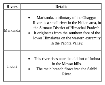
    • Markanda River originates from the lower Shivalik hills in the Paonta valley and enters Haryana near Ambala.
    • It runs through the districts of Ambala, Kaithal and Kurukshetra.
    • Its main tributaries are Tangri, Ran and Begna.
    • It joins the Saraswati at the Sanisa lake.
Test: Geography - II - Question 12
Aruna is the ancient name of which river?
Detailed Solution for Test: Geography - II - Question 12

The correct answer is Markanda.

Key Points

  • Aruna is the ancient name of Markanda river.
    • The Markanda river flows in Sirmaur district, Ambala district, and Markanda town in Kurukshetra district.
    • The river flows through Haryana and Himachal Pradesh.
    • The Markanda river originates from the Shivalik hills.
    • The total length of the river is 120 km out of which 90 km is in Haryana.
    • A barrage at Jalbehra in Kurukshetra district has been built on the river.
    • The Begna river is the main tributary of the Markanda river.

Important Points

  • The Sahibi River originates in Jaipur Distt. of Rajasthan and it passes through Alwar Distt. 
    • It drains into the Yamuna at Delhi, where its channelled course is also called the Najafgarh drain, which also serves as Najafgarh drain bird sanctuary.
  • The Ghaggar River rises in Shivalik hills in the Solan district of Himachal Pradesh.
    • It enters Haryana from the Panchkula district.
    • And at the end, the river leaves Sirsa District of Haryana State and reaches Sri Ganga Nagar district, Rajasthan.
    • Kaushalya river is a left bank tributary of Ghaggar River.
  • Yamuna River is the largest tributary of the Ganga River.
    • It originates from Yamunotri Glacier.
    • It meets the Ganges at the Sangam (where Kumbh Mela is held) in Prayagraj, Uttar Pradesh after flowing through Uttarakhand, Himachal Pradesh, Haryana and Delhi.
    • Length: 1376 km
    • Important Dam: Lakhwar-Vyasi Dam (Uttarakhand), Tajewala Barrage Dam (Haryana) etc.
    • Important Tributaries: Chambal, Sindh, Betwa and Ken.
Test: Geography - II - Question 13
The Dohan river originates from ________.
Detailed Solution for Test: Geography - II - Question 13
  • The Dohan river originates from the Aravalli Range.
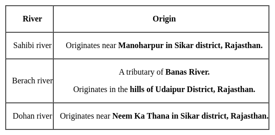
  • It is a rain-fed river that originates at Mandholi village, Rajasthan.
  • The Aravalli Range is also the oldest mountain range in the world.
  • Banas, Luni, and Sabarmati are the rivers that flow through this range.
Test: Geography - II - Question 14

Which of the following rivers does not have their origin in Aravali hills?

Detailed Solution for Test: Geography - II - Question 14
  • Chenab River does not have its origin in Aravali hills.
  • The other three rivers originate from Aravali hills.
  • Chenab River:-

A major river that flows in India and Pakistan, and is one of the 5 major rivers of the Punjab region.

Test: Geography - II - Question 15
Damdama lake is in which place of Haryana?
Detailed Solution for Test: Geography - II - Question 15
Damdamaa reservoir is in Sohna, Haryana. It is one of the biggest lakes in Haryana.
Test: Geography - II - Question 16
Sahibi river originates in which of the following districts?
Detailed Solution for Test: Geography - II - Question 16

The correct answer is Sikar.

Key Points

  • ​Sahibi river:
    • Place of Origin- Jitgarh and Manoharpur of Sikar district in Rajasthan.
    • Entry in Haryana- Kot Kasin Rewari.
    • Passes through districts- Rewari, Gurugram.
    • Tributaries – Sota, Barkania Nala, Indori Nala
    • Merging or ending - gets absorbed in the Najafgarh lake.

Additional Information

Some of the rivers are:

Test: Geography - II - Question 17
The eastern boundary of Haryana with Uttar Pradesh is defined by_________ river.
Detailed Solution for Test: Geography - II - Question 17
  • The eastern boundary of Haryana with Uttar Pradesh is defined by a stretch of about 200 km of Yamuna river.
  • Yamuna River also receives a heavy amount of industrial and domestic pollutants from Yamuna Nagar, Panipat, and Sonipat in this stretch.
Test: Geography - II - Question 18

Which of the following State shares its boundary with Haryana?

Detailed Solution for Test: Geography - II - Question 18

The correct answer is Himachal Pradesh.

  • Himachal Pradesh shares its boundary with Haryana.

Key Points

  • Haryana is a state in the northern region of India with 22 districts.
    • The State borders Punjab and Himachal Pradesh to the north and Rajasthan to the west and south.
    • The river Yamuna defines its eastern border with Uttarakhand and Uttar Pradesh.

Additional Information

  • Haryana also surrounds Delhi on three sides, forming the northern, western and southern borders of Delhi.
  • Consequently, a large area of Haryana is included in the National Capital Region.
Test: Geography - II - Question 19
In which of the following district Kalesar National Park is located?
Detailed Solution for Test: Geography - II - Question 19

The correct answer is Yamunanagar

  • There are two national parks in Haryana.
  • Kalesar National Park is situated in the foothills of Shiwalik ranges of mighty Himalayas. 
    • It falls under Yamunanagar District of Haryana, sharing boundary with three States viz., Himachal Pradesh, Uttranchal & U.P.
    • The Yamuna river forms the Eastern boundary with Uttar Pradesh, the main Shiwalik ridge separates State boundary among Haryana, Himachal Pradesh & Uttaranchal in the north.
  • Sultanpur National Park is a bird paradise for bird watchers.
    •  It is situated in Gurgaon district of Haryana on Gurgaon-Farrukh Nagar road. 
    • Park is famous for its migratory as well as resident birds.
    • Migratory species reach here after covering incredible distance since there homeland in Europe, Siberia and Central Asia become inhabitable due to cold temperature, snow-covered ground and frozen lakes.
    • A total of around 250 bird species have been reported in the park.
Test: Geography - II - Question 20

Which of the following districts of Uttar Pradesh touching the boundary of Haryana state?
1. Saharanpur
2. Shamli
3. Bagpat

Find the right code given below.

Detailed Solution for Test: Geography - II - Question 20

The correct answer is 1, 2, and 3.

Key Points

  • Uttar Pradesh:
    • Its borders touch with a total of 9 states including the Union Territory of Delhi.
    • Uttar Pradesh was formed on 24 January 1950.
    • Its capital is Lucknow.
    • The longest border of Uttar Pradesh touches Madhya Pradesh and the minimum borderline with Himachal Pradesh.
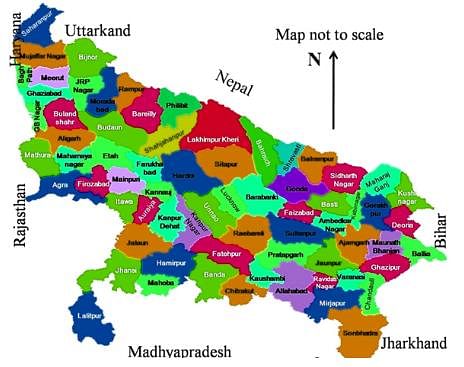
    • Uttar Pradesh borders Uttarakhand, Himachal Pradesh, Haryana, Rajasthan, Madhya Pradesh, Chhattisgarh, Jharkhand, Bihar, and Delhi.
    • Saharanpur, Shamli, Bagpat, Gautam Buddha Nagar, Aligarh, and Mathura shares a boundary with Harayana. Hence, Option 4 is correct.
    • Sonbhadra is the only district in Uttar Pradesh that touches most states. It touches Madhya Pradesh, Chhattisgarh, Jharkhand, and Bihar.
    • Uttar Pradesh boasts of rich history, magnificent cities, amazing tourist sites, and unique traditions and culture. Spread over an area of 243,286 sq. km, Uttar Pradesh is the fourth largest state in the country. Comprising a population of 19.98 crores, according to the 2011 census, the North Indian state of Uttar Pradesh is one of the most populous states in the country.
    • Uttar Pradesh shares its borders with Nepal and Uttarakhand in the north, Delhi and Haryana in the northwest, Rajasthan in the west, Madhya Pradesh in the southwest, Bihar in the east, and Jharkhand in the southeast.

Information about Test: Geography - II Page
In this test you can find the Exam questions for Test: Geography - II solved & explained in the simplest way possible. Besides giving Questions and answers for Test: Geography - II, EduRev gives you an ample number of Online tests for practice
Download as PDF