Class 6 Exam > Class 6 Tests > International Social Studies Olympiad for Class 6 > Test: Globes and Maps - 2 - Class 6 MCQ
Test: Globes and Maps - 2 - Class 6 MCQ
Test Description
10 Questions MCQ Test International Social Studies Olympiad for Class 6 - Test: Globes and Maps - 2
Test: Globes and Maps - 2 for Class 6 2024 is part of International Social Studies Olympiad for Class 6 preparation. The Test: Globes and Maps - 2 questions and answers have been
prepared according to the Class 6 exam syllabus.The Test: Globes and Maps - 2 MCQs are made for Class 6 2024 Exam. Find important
definitions, questions, notes, meanings, examples, exercises, MCQs and online tests for Test: Globes and Maps - 2 below.
Solutions of Test: Globes and Maps - 2 questions in English are available as part of our International Social Studies Olympiad for Class 6 for Class 6 & Test: Globes and Maps - 2 solutions in
Hindi for International Social Studies Olympiad for Class 6 course. Download more important topics, notes, lectures and mock
test series for Class 6 Exam by signing up for free. Attempt Test: Globes and Maps - 2 | 10 questions in 10 minutes | Mock test for Class 6 preparation | Free important questions MCQ to study International Social Studies Olympiad for Class 6 for Class 6 Exam | Download free PDF with solutions
Test: Globes and Maps - 2 - Question 1
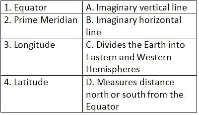
Match the following Earth motions with their descriptions


Detailed Solution for Test: Globes and Maps - 2 - Question 1
Test: Globes and Maps - 2 - Question 2
The tilt of Earth's axis is approximately ____________ degrees.
Detailed Solution for Test: Globes and Maps - 2 - Question 2
| 1 Crore+ students have signed up on EduRev. Have you? Download the App |
Test: Globes and Maps - 2 - Question 3
Equator is to latitude as Prime Meridian is to ____________.
Detailed Solution for Test: Globes and Maps - 2 - Question 3
Detailed Solution for Test: Globes and Maps - 2 - Question 4
Test: Globes and Maps - 2 - Question 5
Indian Standard Time (IST) is based on the standard meridian at ____________ degrees East.
Detailed Solution for Test: Globes and Maps - 2 - Question 5
Detailed Solution for Test: Globes and Maps - 2 - Question 6
Detailed Solution for Test: Globes and Maps - 2 - Question 7
Detailed Solution for Test: Globes and Maps - 2 - Question 8
Test: Globes and Maps - 2 - Question 9
What do we call a book of maps that contains many different kinds of maps?
Detailed Solution for Test: Globes and Maps - 2 - Question 9
Test: Globes and Maps - 2 - Question 10
What is the imaginary line on which the Earth rotates called?
Detailed Solution for Test: Globes and Maps - 2 - Question 10
|
1 docs|32 tests
|
Information about Test: Globes and Maps - 2 Page
In this test you can find the Exam questions for Test: Globes and Maps - 2 solved & explained in the simplest way possible.
Besides giving Questions and answers for Test: Globes and Maps - 2, EduRev gives you an ample number of Online tests for practice
|
1 docs|32 tests
|
Download as PDF


