UGC NET Exam  >  UGC NET Tests  >  UGC NET Mock Test Series 2024  >  UGC NET Paper 2 Geography Mock Test - 10 - UGC NET MCQ

UGC NET Paper 2 Geography Mock Test - 10 - UGC NET MCQ


Test Description

30 Questions MCQ Test UGC NET Mock Test Series 2024 - UGC NET Paper 2 Geography Mock Test - 10

UGC NET Paper 2 Geography Mock Test - 10 for UGC NET 2024 is part of UGC NET Mock Test Series 2024 preparation. The UGC NET Paper 2 Geography Mock Test - 10 questions and answers have been prepared according to the UGC NET exam syllabus.The UGC NET Paper 2 Geography Mock Test - 10 MCQs are made for UGC NET 2024 Exam. Find important definitions, questions, notes, meanings, examples, exercises, MCQs and online tests for UGC NET Paper 2 Geography Mock Test - 10 below.
Solutions of UGC NET Paper 2 Geography Mock Test - 10 questions in English are available as part of our UGC NET Mock Test Series 2024 for UGC NET & UGC NET Paper 2 Geography Mock Test - 10 solutions in Hindi for UGC NET Mock Test Series 2024 course. Download more important topics, notes, lectures and mock test series for UGC NET Exam by signing up for free. Attempt UGC NET Paper 2 Geography Mock Test - 10 | 100 questions in 120 minutes | Mock test for UGC NET preparation | Free important questions MCQ to study UGC NET Mock Test Series 2024 for UGC NET Exam | Download free PDF with solutions
UGC NET Paper 2 Geography Mock Test - 10 - Question 1

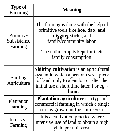
Assertion (A): Environmental and social impact assessments never overlap with each other.

Reason (R):  Environmental and social impact assessments are effectively opposite ends of the same spectrum.

Code:

Detailed Solution for UGC NET Paper 2 Geography Mock Test - 10 - Question 1

Assertion and reasoning type questions have one assertion (A) and one reason (R). We must first determine whether the statement is true. If the statement is true, we must next determine whether the reason correctly explains the assertion.

Key-Points

Assertion (A): Environmental and social impact assessments never overlap with each other.

  • Environmental Impact Assessment (EIA) is a process of evaluating the likely environmental impacts of a proposed project or development, taking into account inter-related socio-economic, cultural, and human-health impacts, both beneficial and adverse.
  • Whereas, Social Impact Assessment (SIA) is the process of identifying and managing the social impacts of industrial projects.
  • It can also be applied to policies, plans, and programs.
  • United Nations Conference on Environment and Development (UNCED) in Rio de Janeiro has stated that we can no longer think of the environment as well as economic and social development as separate fields. 
  • Therefore, Environmental and social impact assessment overlap with each other.

Hence, the statement provided in the assertion is false.

Reason (R):  Environmental and social impact assessments are effectively opposite ends of the same spectrum.

  • Environmental and social impact assessments are effectively opposite ends of the same spectrum.
  • Social impact assessment is less widely applied in EIA today, because of the lack of distinct separation between EIA and SIA. 
  • Thus, in agreement with Barrow, they should be seen as opposite ends of the same spectrum. 

Hence, the statement provided in the reason is true. 

Thus, environmental, and social impact assessments overlap, but they are still separate assessments. Hereby, we can conclude that (A) is false, but (R) is true.

UGC NET Paper 2 Geography Mock Test - 10 - Question 2

Consider the following statements regarding ' Sacred Groves' :

1. They are fragments of forests of special religious importance protected by local communities.

2. They are a type of ex-situ conservation of biodiversity.

Which of the statements given above is/are correct?

Detailed Solution for UGC NET Paper 2 Geography Mock Test - 10 - Question 2

The correct answer is 1 only.

Key Points

  • Sacred groves are fragments of forests protected by local communities.
    • They are also known as “Devaru kadu” in Kannada and “Kavu” in Malayalam.
    • Sacred groves are usually dedicated to local folk deities and protected by communities because of their religious beliefs.
    • Hence statement 1 is correct.
  • It helps in biodiversity conservation, recharge of aquifers, and soil conservation.
    • It is an in-situ method of conservation of biodiversity.
    • Hence statement 2 is not correct.​

Additional Information

  • Hunting and logging are not permitted in the sacred groves. 
  • Limited human interference is allowed in Sacred Groves. 
    • As a result, many sacred groves still exist in urban areas.
  • With increasing urbanization, urban sacred groves are becoming home to a large number of invasive ants.
  • It is a clear indicator of human disturbances in the habitat. 

Important Points

  • Sacred groves in India enjoy exclusive protection under the Wildlife Protection Act, 1972.
  • Himachal Pradesh state has the highest number of sacred groves.
  • 14,000 sacred groves are there in India
1 Crore+ students have signed up on EduRev. Have you? Download the App
UGC NET Paper 2 Geography Mock Test - 10 - Question 3

Which one of the following in the correct sequence of economic integration between countries?

Detailed Solution for UGC NET Paper 2 Geography Mock Test - 10 - Question 3

The Preferential Trade Area is the first step in economic integration. It gives preferred access regarding certain commodities to the participating countries. Free Trade Area is the second step gives reduced tariffs and lessened trade barriers which increases trade of goods and services. Customs Union is the next step after Free Trade area. It has common external tariff. It is designed to end re-exportation. A common market with a customs union forms an economic union. It is 6th stage in economic integration.

Thus, the correct answer is C.

UGC NET Paper 2 Geography Mock Test - 10 - Question 4
In the quaternary age what was the evidence of climate change?
Detailed Solution for UGC NET Paper 2 Geography Mock Test - 10 - Question 4

The quaternary or Pleistocene ice age witness the advance of huge glaciers or ice sheets from different centers. In north America, great glaciers spread out from the centers near the Hudson Bay which buried all set of eastern Canada, New England and much of middle west.

Thus, the Correct answer is A.

UGC NET Paper 2 Geography Mock Test - 10 - Question 5
In the UN’s sustainable development goals are intended to be achieved by the year
Detailed Solution for UGC NET Paper 2 Geography Mock Test - 10 - Question 5

 The sustainable development goals are set of 17 goals designed to achieve the measure and problems of society and the way to sustainable deal with the same. This was set in 2015 by the United Nation general assembly and intended to be achieved by the year 2030.

Thus, the Correct answer is D .

UGC NET Paper 2 Geography Mock Test - 10 - Question 6
Given below are two statements. One is labelled as Assertion (A) and the other is labelled as Reason (R).

Assertion (A): Anti-cyclone leads to violent thunderstorms.

Reason (R): Anti-cyclones have high pressure at its centre.

Select the correct answer from options given below:

Detailed Solution for UGC NET Paper 2 Geography Mock Test - 10 - Question 6

Anti-cyclones are circular patterns of air movement. It has a high-pressure cell at its centre. Anti-cyclones are generally associated with calm weather. They show persistent and yield dry air. Cyclones are generally accompanied with violent thunderstorms. Thus, (A) is false and (R) is true.

Thus, the correct answer is D.

UGC NET Paper 2 Geography Mock Test - 10 - Question 7
What is "Jhoom"?
Detailed Solution for UGC NET Paper 2 Geography Mock Test - 10 - Question 7

The correct answer is A form of agriculture.

Key Points

  • "Jhoom" is a form of agriculture.
  • In this agriculture farming method, the trees and other vegetation that are present on a particular land are cut down to create the field for crop cultivation.
  • "Jhoom" is one of the oldest practices of agriculture systems.
  • Jhoom farming is also known as 'slash and burn agriculture or 'fire-fallow cultivation.
  • It is mostly practiced by the tribal groups in the northeastern states of India like Arunachal Pradesh, Meghalaya, Mizoram, and Nagaland and also in the districts of Bangladesh like Khagrachari and Sylhet.

Additional Information

UGC NET Paper 2 Geography Mock Test - 10 - Question 8
Slum-dwellers in India regularly deal with problems such as:
Detailed Solution for UGC NET Paper 2 Geography Mock Test - 10 - Question 8

The correct answer is All of the above. 

 Key Points

Slum-dwellers in India regularly deal with problems such as

  • lack of clean water
  • constant migration to slums
  • no sewage or waste disposal facilities
  • pollution, and
  • unsanitary living conditions.
  • The basic characteristics of slum housing are:
    • High levels of pollution,
    • lack of basic needs, and
    • room-crowding 
UGC NET Paper 2 Geography Mock Test - 10 - Question 9

This ecosystem constitutes a systematic link between terrestrial and marine ecosystems

Detailed Solution for UGC NET Paper 2 Geography Mock Test - 10 - Question 9

An ecosystem is a geographic area where plants, animals, and other organisms, as well as weather and landscape, work together to form a bubble of life. Ecosystems contain biotic or living parts, as well as abiotic factors, or nonliving parts. Biotic factors include plants, animals, and other organisms. Abiotic factors include rocks, temperature, and humidity.

Mangroves are a group of trees and shrubs that live in the coastal intertidal zone, between land and sea, in the (sub) tropics.

  • All of these trees grow in areas with low-oxygen soil, where slow-moving waters allow fine sediments to accumulate.
  • Mangrove forests only grow at tropical and subtropical latitudes near the equator because they cannot withstand freezing temperatures.
  • They provide a wide range of ecosystem services, including coastal protection, carbon sequestration, and opportunities for biodiversity.
  • Animals found are similar to those commonly found in tropical terrestrial forests and marine ecosystems such as the giant centipede, Scolopendra, hunting spiders (Lycosidae), and octopus.
  • Mangrove forests stabilize the coastline, reducing erosion from storm surges, currents, waves, and tides.
  • The intricate root system of mangroves also makes these forests attractive to fish and other organisms seeking food and shelter from predators.

Hence, it is clear that Mangrove forests occur at the interface between land (terrestrial) and sea (marine), and as a consequence, these forests span both aquatic and terrestrial realms.

Additional Information

Evergreen forests are a category containing multi-story forests, where more than 80% of tree species keep their leaves during the entire year. In India, they are found in the Andaman and Nicobar Islands, the Western Ghats, which fringe the Arabian Sea, the coastline of peninsular India, and the greater Assam region in the north-east.
Rain forests are simply an area of tall, mostly evergreen trees and a high amount of rainfall. This dense rain forest is on the island of Borneo, which straddles two oceans (the Indian and the South Pacific) and is shared by three nations (Indonesia, Malaysia, and Brunei).

Mango forests- There no such category of the forest.

UGC NET Paper 2 Geography Mock Test - 10 - Question 10
The Concentric circle theory of city morphology was developed by:
Detailed Solution for UGC NET Paper 2 Geography Mock Test - 10 - Question 10

The correct answer is E. Burgess.
Important Points
Concentric circle theory

  • The Concentric Circle Theory of city morphology was developed by sociologist E. Burgess in 1925.
  • Burgess was interested in studying the social organization of cities, particularly the ways in which different social groups interacted with each other in urban areas.

According to Burgess, cities grow in a series of concentric circles, with each circle representing a different type of land use and social group.

  • The innermost circle is the central business district (CBD), which is the economic and commercial hub of the city. Surrounding the CBD is the zone of transition, which is a mixed-use area characterized by industrial and residential land uses.
  • Burgess argued that this area was often home to marginalized and transient populations, including recent immigrants, the working poor, and the homeless.

The next concentric circle is the zone of working-class homes,

  • which is a predominantly residential area characterized by low-income housing and blue-collar workers. Beyond this is the zone of better residences, which is a middle-class residential area characterized by single-family homes and a higher standard of living.

Finally, the outermost concentric circle is the commuter zone, which is a suburban area where people live who commute to the central city for work.

Burgess believed that this pattern of concentric circles was universal and could be observed in cities around the world. He argued that the concentric circle model reflected the natural tendency of social groups to sort themselves based on their socio-economic status and land use needs.

In conclusion, the Concentric Circle Theory of city morphology was developed by E. Burgess and proposes that cities grow in a series of concentric circles, each with a different type of land use and social group. The innermost circle is the CBD, followed by the zone of transition, zone of working-class homes, zone of better residences, and finally the commuter zone.

UGC NET Paper 2 Geography Mock Test - 10 - Question 11

Which of the following factors influence the distribution of the population?

1. Landforms

2. Minerals

3. Soils

4. Industrialization

Select the correct answer from the code given below:

Detailed Solution for UGC NET Paper 2 Geography Mock Test - 10 - Question 11

The correct answer is 1, 2, 3, and 4.

Important Points

FACTORS INFLUENCING THE DISTRIBUTION OF POPULATION:

  • Geographical Factors:
    • Availability of water: It is the most important factor for life. So, people prefer to live in areas where fresh water is easily available. Water is used for drinking, bathing, and cooking – and also for cattle, crops, industries, and navigation.
    • Landforms: People prefer living on flat plains and gentle slopes. This is because such areas are favorable for the production of crops and to build roads and industries.
    • Climate: An extreme climate such as very hot or cold deserts are uncomfortable for human habitation. Areas with a comfortable climate, where there is not much seasonal variation attract more people.
    • Soil: Fertile soils are important for agricultural and allied activities. Therefore, areas that have fertile loamy soils have more people living on them as these can support intensive agriculture.
  • Economic Factors:
    • Minerals: Areas with mineral deposits attract industries. Mining and industrial activities generate employment. So, skilled and semi-skilled workers move to these areas and make them densely populated.
    • Urbanisation: Cities offer better employment opportunities, educational and medical facilities, better means of transport and communication. It leads to rural to urban migration and cities grow in size.
    • Industrialisation: Industrial belts provide job opportunities and attract large numbers of people. These include not just factory workers but also transport operators, shopkeepers, bank employees, doctors, teachers, and other service providers.
  • Social and Cultural Factors:
    • Some places attract more people because they have religious or cultural significance.
    • In the same way – people tend to move away from places where there is social and political unrest.
UGC NET Paper 2 Geography Mock Test - 10 - Question 12

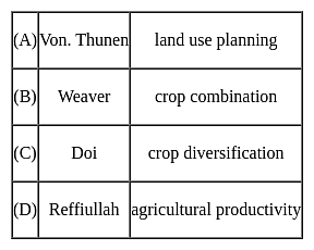
The following pairs are given about the contribution of geographer's in Agricultural geography and find out which is not correct?
Detailed Solution for UGC NET Paper 2 Geography Mock Test - 10 - Question 12

The correct answer is D.

Key Points

  • Von Thunen conceived the idea of a land-use model in both urban and rural landscapes around a city on an isotropic landscape. His idea is basically how economic rent decreases from the center of a city to its periphery. His system of land use around a city with no trade alliance with any other country is ring-shaped.
  • In the field of agricultural geography, Weaver (1954) was the first to use statistical techniques for the demarcation of crop combination regions of the Middle West (USA). In his attempt to demarcate the agricultural regions of the Middle West (USA), Weaver based his analysis on acreage statistics.
  • Crop diversification refers to the addition of new crops or cropping systems to agricultural production on a particular farm taking into account the different returns from value-added crops with complementary marketing opportunities. Crop diversification is a concept that is opposite to crop specialization. Farmers all over the world, especially in developing countries, try to grow several crops in their holdings in an agricultural year. For the measurement of crop diversification, Doi and Bhatia (1965) developed a formula based on the gross cropped area.
  • There are several ways to measure crop diversification, and the most important include Herfindahl Index, Simpson Diversity Index, Ogive Index, Margalef Index, Shannon Index, Berger-Parker Index, and Entropy Index.
  • Jasbir Singh has proposed a unique method for the measurement of Agricultural Productivity which is in terms of monetary value earned from agriculture per capital-labor employed.
  • He proposed that agricultural productivity is the summation of the product of the output of production of the crop and its market price, from which the cost of production is subtracted. Agricultural Productivity= ∑( Pij*Mij)-Cop- Here P is output or production in quantity of the crop, M is the Market price and Cop is the cost of Production.
UGC NET Paper 2 Geography Mock Test - 10 - Question 13
Which of the following is not a part of Social Geography?
Detailed Solution for UGC NET Paper 2 Geography Mock Test - 10 - Question 13
UGC NET Paper 2 Geography Mock Test - 10 - Question 14
The sum of deviations taken away from the mean is:
Detailed Solution for UGC NET Paper 2 Geography Mock Test - 10 - Question 14

The correct answer is option 1) always equal to 0.

Key Points

  • Deviation is the distance between each data point and the mean of the data set.
  • The sum of deviations taken away from the mean is calculated by adding up all the distances between each data point and the mean.
  • The sum of deviations taken away from the mean is always equal to 0, regardless of the data set.

Additional Information

  • This property of the sum of deviations from the mean is used to calculate variance and standard deviation, which are important statistical measures.
  • The formula for calculating the sum of deviations taken away from the mean is: ∑(Xi - X̄) = 0, where Xi represents each data point and X̄ represents the mean of the data set.
  • This property is a consequence of the fact that the mean is the balancing point of the data set, where the sum of deviations above the mean is equal to the sum of deviations below the mean.

Hence, the sum of deviations taken away from the mean is always equal to 0, regardless of the data set.

UGC NET Paper 2 Geography Mock Test - 10 - Question 15

The transition to renewable energy sources like solar and wind power is crucial for addressing global warming because they:

Detailed Solution for UGC NET Paper 2 Geography Mock Test - 10 - Question 15

Option 4) Both 2 and 3.

The transition to renewable energy sources such as solar and wind power is essential for mitigating global warming, as they offer a number of advantages over fossil fuels. These advantages include:

Key Points

  • Offer a readily available and abundant global energy source: Solar and wind energy are abundant and widely distributed, making them a sustainable and cost-effective alternative to fossil fuels.
  • Produce significantly less greenhouse gas emissions compared to fossil fuels: Renewable energy sources produce significantly lower greenhouse gas emissions than fossil fuels, making them a key solution to climate change.

Hence, the transition to renewable energy sources like solar and wind power is crucial for addressing global warming because they offer a readily available, abundant, and low-carbon energy source. By reducing our reliance on fossil fuels, we can reduce greenhouse gas emissions and mitigate the effects of climate change.

Important Points

Renewable energy sources also offer other benefits, such as:

  • Job creation: The renewable energy industry is a rapidly growing sector, creating new jobs in manufacturing, installation, and maintenance.
  • Reduced air pollution: Renewable energy sources do not produce air pollution, unlike fossil fuels, which can cause health problems and environmental damage.
  • Increased energy independence: By utilizing domestic renewable energy resources, countries can reduce their dependence on foreign oil and gas imports, enhancing their energy security.
UGC NET Paper 2 Geography Mock Test - 10 - Question 16

Which of the following is NOT a direct consequence of global warming?

Detailed Solution for UGC NET Paper 2 Geography Mock Test - 10 - Question 16

Option 4) Expansion of deserts and decrease in overall rainfall.

Global warming is a major threat to the planet, and it is already having a number of serious consequences. These consequences include rising sea levels, increased frequency and intensity of extreme weather events, and disruption of water supplies from melting glaciers. However, not all of the options listed in the query are direct consequences of global warming.

Key Points

Expansion of deserts and decrease in overall rainfall

  • Expansion of deserts and decrease in overall rainfall is not a direct consequence of global warming.
  • While climate change can affect precipitation patterns, it is not clear whether it will lead to an expansion of deserts and a decrease in overall rainfall.
  • Global warming is a serious threat to the planet, and it is important to take action to reduce greenhouse gas emissions and mitigate its effects.

Additional Information

Rising sea levels

Rising sea levels is a direct consequence of global warming. As the Earth's atmosphere warms, the oceans expand and glaciers melt, causing sea levels to rise. Rising sea levels can lead to flooding, erosion, and other coastal hazards.

Increased frequency and intensity of extreme weather events

Increased frequency and intensity of extreme weather events is a direct consequence of global warming. As the Earth's atmosphere warms, it can hold more moisture, which can lead to more frequent and intense storms, floods, and droughts.

Disruption of water supplies from melting glaciers

Disruption of water supplies from melting glaciers is a direct consequence of global warming. As glaciers melt, they can disrupt water supplies for communities and ecosystems downstream.

UGC NET Paper 2 Geography Mock Test - 10 - Question 17

Which is not an effect of ocean current on the socio-economic and climatic condition of the coastal region?

Detailed Solution for UGC NET Paper 2 Geography Mock Test - 10 - Question 17

Ocean currents

  • Ocean currents are like rivers flowing in oceans.
  • They represent a regular volume of water in a definite path and direction.
  • Ocean currents are influenced by two types of forces namely :
    • Primary forces that initiate the movement of water;
    • Secondary forces that influence the currents to flow

Important Point

​​The primary forces that influence the currents are

  • Heating by solar energy
  • Wind
  • Gravity

Coriolis force

  • The Coriolis force intervenes and causes the water to move to the right in the northern hemisphere and to the left in the southern hemisphere.
  • These large accumulations of water and the flow around them are called Gyres.
  • These produce large circular currents in all the ocean basins.

Key Points

Effects of Ocean Currents

  • Ocean currents have a number of direct and indirect influences on human activities.
  • West coasts of the continents in tropical and subtropical latitudes (except close to the equator) are bordered by cool waters.
    • Their average temperatures are relatively low with narrow diurnal and annual ranges.
    • There is fog, but generally, the areas are arid.
  • West coasts of the continents in the middle and higher latitudes are bordered by warm waters which cause a distinct marine climate.
    • They are characterized by cool summers and relatively mild winters with a narrow annual range of temperatures.
  • Warm currents flow parallel to the east coasts of the continents in tropical and subtropical latitudes.
    • This results in warm and rainy climates.
    • These areas lie in the western margins of the subtropical anti-cyclones.
  • The mixing of warm and cold currents helps to replenish the oxygen and favor the growth of planktons, the primary food for the fish population.
    • The best fishing grounds of the world exist mainly in these mixing zones.

Hence, it is can be concluded from the above discussion that the deflection of wind due to the Coriolis force is not an effect of ocean current.

UGC NET Paper 2 Geography Mock Test - 10 - Question 18
Which of the following local winds is also called "Doctor Wind"?
Detailed Solution for UGC NET Paper 2 Geography Mock Test - 10 - Question 18
  • The Harmattan Wind in Niger which is also known as "the Doctor wind”, is a cool wind that brings relief from the major heat.
  • It is named so because of its invigorating dryness compared to the humid tropical air.
  • The Harmattan wind stream during the northern winter generally extends south of the equator as an upper air wind over the south-westerly monsoon.
UGC NET Paper 2 Geography Mock Test - 10 - Question 19
Which one of the following is the major characteristic of deciduous trees?
Detailed Solution for UGC NET Paper 2 Geography Mock Test - 10 - Question 19

The correct answer is They shed their leaves annually.

  • Deciduous trees:
    • Deciduous trees are trees that drop their leaves for part of the year.
    • They are found in temperate and tropical climates all over the world.
    • Deciduous trees have broad flat leaves that catch a lot of light and require a great amount of water.
    • In some cases, leaf loss coincides with winter - namely in temperate or polar climates when there is less sunlight for the process of photosynthesis.
    • In other parts of the world, including tropical, subtropical, and arid regions, deciduous trees lose their leaves during the dry season or other seasons, depending on variations in rainfall.
    • This allows the trees to enter a dormant period during the difficult times as a means of survival.
    • The process of shedding unneeded parts, such as leaves, is known as abscission.

Important Points

  • Note: Unlike deciduous trees, evergreen trees, such as pine and cedar trees, keep their needles year-round.
UGC NET Paper 2 Geography Mock Test - 10 - Question 20
Which of the following type was not included in seven-fold system of land classification given by L.D. Stamp?
Detailed Solution for UGC NET Paper 2 Geography Mock Test - 10 - Question 20

Correct Answer: Rural areas.

Key Points

  • In general, land use classification has two components, under The assessment of physical quality and the agricultural potential of the land. This is also known as ‘land capability’. The physical properties of land are almost unchangeable. In fact, the character and quality of land and its soil depend on the parent material, temperature, rainfall, water-retaining capacity, soil texture, soil structure, and humus contents. These properties of land do not change over a shorter period of time.
  • The assessment of land quality under the prevailing set of socioeconomic circumstances including farm structure, availability of irrigation, the relative cost of labor, capital inputs, level of technology, and price stability. The economic and social controls on production are more variable. A number of land use classification systems are in vogue in different countries of the world.
  • The first systematic land classification was done by L.D. Stamp.
  • In his land classification of Britain, Stamp adopted a seven-fold system, i.e. Arable, Heath and rough, Pastures, Orchards and nurseries, Meadowland, Forest and woodland, and Urban areas.
  • The details and justification of this classification in Stamp’s monumental work The Land of Britain: Its Use and Misuse. This classification helped in overcoming many of the problems pertaining to the demand of land after the Second World War.
  • Subsequently, Coleman, a student of Stamp, adopted a classification of 13 major classes with various subdivisions, making 70 land-use types in all. The International Geographical Union (IGU) resolved to produce a unified classification system for the whole world but in the absence of adequate and reliable data, particularly about developing countries, it could not become possible.

Additional Information

  • In India, M. Shafi is the pioneer of land use studies. He published the Land Use Survey in Eastern Uttar Pradesh in 1962. Under his supervision, over two dozen students completed their doctoral theses in the field of agricultural land use studies. The availability of satellite imageries has revolutionized the whole technique of land use classification. The main weakness of the traditional land use survey is that it gives only a static description of existing land use and is very time, effort and money consuming.
UGC NET Paper 2 Geography Mock Test - 10 - Question 21

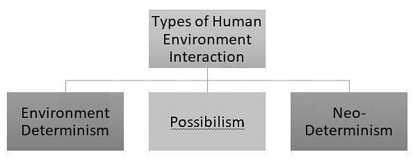
Which of the following are Model(s) of interaction between Human and Environment?

Detailed Solution for UGC NET Paper 2 Geography Mock Test - 10 - Question 21

UGC NET Paper 2 Geography Mock Test - 10 - Question 22
Which of the following statements about spatial data is true?
Detailed Solution for UGC NET Paper 2 Geography Mock Test - 10 - Question 22

The correct answer is option 2.

Concept:

Spatial data:

Spatial data is any kind of data that refers to a certain geographical region or place, either directly or indirectly. Spatial data, also known as geospatial data or geographic information, can quantitatively represent a physical item in a geographic coordinate system so spatial data mean data that has positional values.

  • The internet of things requires spatial data (IoT).
  • It enables IoT protocols to collect data for geographical analysis via remote sensing.
  • Spatial data is also utilised in transportation and logistics to assist firms to identify which machine would operate best in a given place, produce precise delivery time estimates, and track deliveries in real-time.

Hence the correct answer is By 'spatial data' we mean data that has positional values.

UGC NET Paper 2 Geography Mock Test - 10 - Question 23
Which of the following industries is NOT a significant contributor to the economy of Bihar?
Detailed Solution for UGC NET Paper 2 Geography Mock Test - 10 - Question 23

The correct answer is Automobile Manufacturing

Key Points

  • Bihar, an eastern state of India, has a diverse economy with several key industries. Agriculture is a major sector, with a significant portion of the population engaged in farming. The state is a major producer of crops like rice, wheat, and maize.
  • The food processing industry is another major contributor, closely linked with agriculture. It involves the processing of fruits, vegetables, dairy products, meat, and grains, adding value to agricultural produce and creating employment opportunities.
  • The textile industry, particularly silk and cotton, is also significant in Bihar. The state is known for its Bhagalpuri silk, and the textile industry provides employment to a large number of people and contributes to the state's exports.
UGC NET Paper 2 Geography Mock Test - 10 - Question 24
Choose the correct option:-
Detailed Solution for UGC NET Paper 2 Geography Mock Test - 10 - Question 24

The international trade is termed as the Economic barometer of a country because when one country exchanges goods with another country, it is known as foreign trade. This trade leads to economic prosperity and is important both as a source of imports and exports. The international trade is termed as an economic barometer as it shows the trend of the exports and imports and general economy.

From 2000-01, India's foreign trade grew up to a great extent, improved global growth and various policy initiatives were responsible for the improved exports. Another reason that led to this performance was that the value of exports had increased.

UGC NET Paper 2 Geography Mock Test - 10 - Question 25

A tourist in Mumbai observes high tide near Gateway of India at 7.00 AM. At what time, he should expect another high tide on the same day?

Detailed Solution for UGC NET Paper 2 Geography Mock Test - 10 - Question 25

Most coastal areas experience two high and two low tides per day. One of these high tides is at the point on the earth which is closest to the moon (sub lunar) and other high tide is at the opposite point on the earth (antipodal). One tidal cycle comprises two high tides and two low tides. One tidal cycle completes in 24 hours and 50.4 minutes. This is because of the revolution of Moon around the earth and both earth’s rotation and moon revolution are in same direction. (Moon is not stationary, so there is a difference, if moon were stationary the high tides would have occurred exactly in 12 hours). The high tides occur at an interval of 12 hours and 25.2 minutes. This means that if there is a high tide is at 7.00 am, next high tide would be at 7.25 pm and next would be at 7.50 am, and so on. The time difference between two high tides is called “Tidal Interval”. The tidal cycle in this pattern is called semidiurnal. However, most of the enclosed water bodies or away from the open ocean such as Caribbean Sea or Caspian Sea, there are only one high tide and one low tide. This pattern is called Diurnal tides. At the coast of the oceans, there may be two high tides, of unequal length. This is called Mixed Tides.

UGC NET Paper 2 Geography Mock Test - 10 - Question 26
Given below are the two statements, one labelled as Assertion (A) and the other labelled as Reason (R). Select your answer from the code given below:

Assertion (A)- Habitat shifts provide important evidence of population changes.

Reason (R) - Habitats are ecological space that are composed of multiple dimensions, each representing a biotic or abiotic ecological variable.

Detailed Solution for UGC NET Paper 2 Geography Mock Test - 10 - Question 26

The habitat of specie describes the environment over which a species is known to occur and type of community that is formed as a result. Habitats can be defined as regions on ecological space that are composed of multiple dimensions, each representing a biotic or abiotic ecological variable. Habitat shifts gives the information about various population changes relative to habitats that most other individuals of species occupy.

Thus, the Correct answer is A.

UGC NET Paper 2 Geography Mock Test - 10 - Question 27
Which of the following statement best characterizes New International Division of Labour?
Detailed Solution for UGC NET Paper 2 Geography Mock Test - 10 - Question 27

The New International Division of Labour (NIDL), is the consequence of globalization and is referred to as the characteristic feature of the Post-Fordist era. The high paying jobs are still concentrated in the core economies and the low-paying jobs within the same industry is concentrated in the third world countries. Example, the shoemaking will be done in cottage industries of Bangladesh for large MNCs whose headquarter and the R&D wing is situated in United States.

UGC NET Paper 2 Geography Mock Test - 10 - Question 28
Which of the following is NOT a reason for a glacial lake outburst flood?
Detailed Solution for UGC NET Paper 2 Geography Mock Test - 10 - Question 28

The Glacial Lake outburst flow (GLOF) occurs when the dam that contains the glacial lake falls. It can occur due to an avalanche of heavy snow and rock, an earthquake or volcanic eruption under the ice, erosion, pressure due to buildup of water, etc.

UGC NET Paper 2 Geography Mock Test - 10 - Question 29

Heritage power project Sonapani mini-hydel power project is located in which state?

Detailed Solution for UGC NET Paper 2 Geography Mock Test - 10 - Question 29

Sonapani Power Project is the name of a British Era heritage mini-hydel project located at Lum Kshaid in Meghalaya. It was set up in 1925, abandoned in 1982, and again construction started in 2001. The heritage project of 1.5 MW capacity was recommissioned in December 2011.

UGC NET Paper 2 Geography Mock Test - 10 - Question 30

India's population growth is characterized by

Detailed Solution for UGC NET Paper 2 Geography Mock Test - 10 - Question 30

India's population growth is characterised by decadal (on every 10 year basis) growth of population on every census basis, which is based on an increase in the birth rate and decrease in death rate.

View more questions
16 docs|120 tests
Information about UGC NET Paper 2 Geography Mock Test - 10 Page
In this test you can find the Exam questions for UGC NET Paper 2 Geography Mock Test - 10 solved & explained in the simplest way possible. Besides giving Questions and answers for UGC NET Paper 2 Geography Mock Test - 10, EduRev gives you an ample number of Online tests for practice

Top Courses for UGC NET

Download as PDF

Top Courses for UGC NET