Civil Engineering (CE) Exam  >  Civil Engineering (CE) Tests  >  Geomatics Engineering (Surveying)  >  Test: Contouring - Civil Engineering (CE) MCQ

Test: Contouring - Civil Engineering (CE) MCQ


Test Description

10 Questions MCQ Test Geomatics Engineering (Surveying) - Test: Contouring

Test: Contouring for Civil Engineering (CE) 2024 is part of Geomatics Engineering (Surveying) preparation. The Test: Contouring questions and answers have been prepared according to the Civil Engineering (CE) exam syllabus.The Test: Contouring MCQs are made for Civil Engineering (CE) 2024 Exam. Find important definitions, questions, notes, meanings, examples, exercises, MCQs and online tests for Test: Contouring below.
Solutions of Test: Contouring questions in English are available as part of our Geomatics Engineering (Surveying) for Civil Engineering (CE) & Test: Contouring solutions in Hindi for Geomatics Engineering (Surveying) course. Download more important topics, notes, lectures and mock test series for Civil Engineering (CE) Exam by signing up for free. Attempt Test: Contouring | 10 questions in 30 minutes | Mock test for Civil Engineering (CE) preparation | Free important questions MCQ to study Geomatics Engineering (Surveying) for Civil Engineering (CE) Exam | Download free PDF with solutions
Test: Contouring - Question 1

Which of the following type of levelling is necessary across a river ravine or any obstacle requiring a long site between two points?

Detailed Solution for Test: Contouring - Question 1

When it is necessary to carry a levelling across a river ravine or any obstacle requiring a long site between two points so situated that no place for the level can be found from which the lens of foresight and backsight will be even approximately equal, special method that is reciprocal levelling must be used. It is used to obtain better accuracy.

Test: Contouring - Question 2

According to the basic principles of contouring, which of the following is true?

Detailed Solution for Test: Contouring - Question 2

Contour:
Line joining points of the same elevation are called contour lines.
Contour Interval

  • A contour interval is a vertical distance or difference in elevation between contour lines.
  • It is always kept the same or constant for a map.

The contour interval depends upon the following factors

  • The scale of the map
    • The contour interval normally varies inversely to the scale of the map i.e., if the scale of the map is large, the contour interval is considered to be small and vice versa.
  • Purpose of the map
    • For a very important and detailed design, contour intervals should be kept small.
  • Nature of ground
    • For flat ground, a small contour interval is chosen whereas, for undulating and broken ground, a greater contour interval is adopted.
  • Time & Cost
    • If the contour interval is small, greater time and funds will be required in the field survey, in reduction, and in plotting the map. If the time and funds available are limited, the contour interval may be kept large.
  • Slope
    • Contour interval is directly proportional to the slope. Contour intervals for flat countries are generally small, e.g. 0.25 m, 0.5 m, 0.75 m, etc. Contour interval in hilly areas is generally greater, e.g. 5 m, 10 m, 15 m, etc.

Additional Information
Characteristics of contour lines

  • Two contour lines do not intersect each other except in the case of an overhanging cliff and a cave penetrating a hill.
  • All lines close themselves within the map boundaries or outside it.
  • If the contour lines are very close to each other, this indicates a steep slope.
  • If the contour lines are at a very large distance from each other, this indicates a gentle slope.
  • If the closed lines have higher elevation in the center then it represents the hill or mountain.
  • If the closed line has increasing elevation as we move away, then it represents a pond or a depression in the ground profile.
  • The direction of the steepest slope is along with the shortest between the contours.
1 Crore+ students have signed up on EduRev. Have you? Download the App
Test: Contouring - Question 3

Which of the following type of levelling is used when two points so situated that no place for the level can be found from which the lens of foresight and backsight will be even approximately equal?

Detailed Solution for Test: Contouring - Question 3

When it is necessary to carry a levelling across a river ravine or any obstacle requiring a long site between two points so situated that no place for the level can be found from which the lens of foresight and backsight will be even approximately equal, special method that is reciprocal levelling must be used. It is used to obtain better accuracy.

Test: Contouring - Question 4

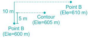
For locating contours by indirect method, two guide points A (Elevation = 600 m) and B (Elevation = 610 m) are established. The horizontal distance between the two points on the plan is 1 cm. Find the distance of the contour of 605 m from point A (on the plan).

Detailed Solution for Test: Contouring - Question 4

Given data:
Elevation of point A (Elev.A) = 600 m
Elevation of point B (Elev.B) = 610 m
The horizontal distance between point A and point B on the plan = 1 cm
Distance of the contour of 605 m from point A on the plan =?
The vertical distance (interval) between point A and point B
= Elevation of point B - Elevation of point A 

The vertical distance (interval) between point A and point B = 610 - 600 = 10 m
10 m vertical distance is equal to 1 cm horizontal distance on the plan.
1 m vertical distance = 0.1 cm (horizontal distance on plan)
The vertical distance (interval) between point A and the contour of 605 m = 605 - 600 = 5 m
5 m vertical distance = 5 × 0.1 = 0.5 cm (horizontal distance on plan)
The horizontal distance of the contour of 605 m from point A on the plan is 0.5 cm.

Test: Contouring - Question 5

Which of the following error cannot be eliminated in reciprocal levelling?

Detailed Solution for Test: Contouring - Question 5

Reciprocal levelling must be used to obtain better accuracy. It is also used to eliminate error in instrument adjustment, combined effect of earth’s curvature and refraction of atmosphere, variations in average refraction.

Test: Contouring - Question 6

Which of the following method is used for locating points on the ground by distance measurement and finding their elevations using a level.

Detailed Solution for Test: Contouring - Question 6

Contouring

  • Contour line is an important aspect of surveying which basically involves the determination of the height of different points on the ground after fixing the points of equal horizontal position in the contour map. Or in other words, the determination of elevation of various points on the land (ground) using a leveling instrument and fixing these points of the same horizontal positions in the contour map. A contour can be defined as an imaginary line that passes through points of equal elevation.

Traversing

  • A traverse is a series of connected lines whose lengths and directions are to be measured and the process of surveying to find such measurements is known as traversing.

Leveling

  • Levelling or leveling is a branch of surveying, which aims to establish or verify or measure the height of specified points relative to a datum.

Theodolite

  • A theodolite is a precision optical instrument used for measuring angles both horizontally and vertically.
Test: Contouring - Question 7

When an instrument is at P the staff readings on P is 1.824 and on Q is 2.748. When the instrument at Q the staff readings on P is 0.928 and Q is 1.606. Distance between P and Q is 1010 mts. R.L. of P is 126.386. Find true R.L. of Q?

Detailed Solution for Test: Contouring - Question 7

When observations are taken from P the apparent difference in elevation between P and Q is 2.748 – 1.824 = 0.924. When observations are taken from Q the apparent difference in elevation between P and Q is 1.606 – 0.928 = 0.678. Hence true difference in elevation is (0.924 +0.678)/2 = 0.801 m. Therefore true elevation of Q is 126.386 – 0.801 = 125.585 m.

Test: Contouring - Question 8

Under which of the following circumstances can the contour lines of different elevations intersect each other?

Detailed Solution for Test: Contouring - Question 8

Contour lines are the lines joining the points of equal elevation on the ground surface.
Characteristic of the contour lines are:

  • Two contour lines of different elevation cannot cross each other.
  • Contour lines of different elevations can unite to form one line only in case of a vertical cliff.
  • However, contour lines of different elevations can intersect only in case of an overhanging Cliff and a cave.
  • Contour lines crosses a valley or ridge line at 90º.
  • Closed contours show either hill or pond.
Test: Contouring - Question 9

When instrument is at P the staff readings on P is 1.824 and on Q is 2.748. When instrument at Q the staff readings on P is 0.928 and Q is 1.606. Distance between P and Q is 1010 mts. R.L. of P is 126.386. Find combined correction for curvature and refraction?

Detailed Solution for Test: Contouring - Question 9

Combined correction for curvature and refraction is 0.06728 d2 = 0.06728(1.010)2 = 0.069 mts.

Test: Contouring - Question 10

The suitable contour interval for a map with scale 1: 10,000 is

Detailed Solution for Test: Contouring - Question 10

Concept:
Contour Interval = 25/(No. of cm per km) (metres)
Also Contour Interval = 50/(No. of inches per mile) (feet)
Calculation:
For the scale of 1: 10000.
1 cm represents 10000 cm
∴ 1 cm represents 10000 × 10-5 km = 0.1 km
∴ 1 cm represents 0.1 km. So 1 km represent 10 cm
∴ Contour interval = 25/10 = 2.5 meters
Hence, the most appropriate answer is option 1.

19 videos|31 docs|35 tests
Information about Test: Contouring Page
In this test you can find the Exam questions for Test: Contouring solved & explained in the simplest way possible. Besides giving Questions and answers for Test: Contouring, EduRev gives you an ample number of Online tests for practice

Up next

Download as PDF

Up next