UPSC  >  Geography for UPSC CSE  >  Test: Drainage - 2 Download as PDF

Test: Drainage - 2 - UPSC


Test Description

30 Questions MCQ Test Geography for UPSC CSE - Test: Drainage - 2

Test: Drainage - 2 for UPSC 2023 is part of Geography for UPSC CSE preparation. The Test: Drainage - 2 questions and answers have been prepared according to the UPSC exam syllabus.The Test: Drainage - 2 MCQs are made for UPSC 2023 Exam. Find important definitions, questions, notes, meanings, examples, exercises, MCQs and online tests for Test: Drainage - 2 below.
Solutions of Test: Drainage - 2 questions in English are available as part of our Geography for UPSC CSE for UPSC & Test: Drainage - 2 solutions in Hindi for Geography for UPSC CSE course. Download more important topics, notes, lectures and mock test series for UPSC Exam by signing up for free. Attempt Test: Drainage - 2 | 30 questions in 30 minutes | Mock test for UPSC preparation | Free important questions MCQ to study Geography for UPSC CSE for UPSC Exam | Download free PDF with solutions
1 Crore+ students have signed up on EduRev. Have you? Download the App
Test: Drainage - 2 - Question 1

Which of the following is the result of concern over rising pollution in our rivers?

Detailed Solution for Test: Drainage - 2 - Question 1

The Government of India and many concerned state governments have started implementing various programmes to deal with the problems arising out of river pollution. They have made action plans and are vigorously implementing these plans.

Test: Drainage - 2 - Question 2

Which of the following affects the self-cleansing capacity of the river?

Detailed Solution for Test: Drainage - 2 - Question 2

The self cleansing capacity of a river refers to the natural ways in which the river gets rid of the pollutants discharged into it. The flow of the river, the presence of bacteria which decompose the pollutants and make them into harmless substances, are some factors which contribute to the self cleansing capacity of the river. But this can work to a certain limit only. Natural processes can help to keep the river clean to a certain extent but they cannot overcome uncontrolled pollution.

Test: Drainage - 2 - Question 3

Which of the following is not one of the causes of river pollution?

Detailed Solution for Test: Drainage - 2 - Question 3

The aquatic organisms cause no harm to rivers it’s the human activities that causes pollution to happen breaking the ecosystem balance.

Test: Drainage - 2 - Question 4

Which one of the following cities of India is not located on a riverbank?

Detailed Solution for Test: Drainage - 2 - Question 4

To identify the city in India that is not located on a riverbank, we need to examine the given options and determine which city does not have a river flowing through it.
1. Haridwar: This city is located in the state of Uttarakhand and is situated on the banks of the Ganges River. Therefore, it is located on a riverbank.
2. Allahabad: Now known as Prayagraj, this city is located in the state of Uttar Pradesh. It is situated at the confluence of the Ganges, Yamuna, and Saraswati rivers. Hence, it is also located on a riverbank.
3. Shillong: This city is the capital of the Indian state of Meghalaya. Unlike Haridwar and Allahabad, Shillong is not located on a riverbank. It is situated on the Shillong Plateau, surrounded by hills. Therefore, Shillong is the correct answer as it is not located on a riverbank.
4. Varanasi: Also known as Banaras or Kashi, Varanasi is a city in Uttar Pradesh. It is situated on the banks of the Ganges River, making it another city located on a riverbank.
Answer: The city of Shillong in India is not located on a riverbank.
Test: Drainage - 2 - Question 5

Lakes are of great value to human beings. Which of the following statements about lakes given below is incorrect?

Detailed Solution for Test: Drainage - 2 - Question 5
Incorrect Statement: B. It results in flooding.
Explanation:
Lakes are indeed of great value to human beings. They provide numerous benefits and services to both the environment and society. However, statement B, which claims that lakes result in flooding, is incorrect.
Here is a detailed explanation of the correct statements about lakes:
A. Helps to regulate the flow of rivers:
- Lakes act as natural reservoirs, storing water during periods of high rainfall and releasing it during dry periods.
- This helps to regulate the flow of rivers, ensuring a more consistent water supply downstream.
C. Can be used for developing hydel power:
- Lakes with sufficient water volume and elevation difference can be utilized for hydropower generation.
- Water from the lake is directed through turbines, which in turn generate electricity.
D. Enhances natural beauty:
- Lakes are visually appealing and often serve as recreational areas for boating, fishing, swimming, and other outdoor activities.
- The presence of lakes can enhance the natural beauty of an area and attract tourists.
Therefore, the incorrect statement is B. It is important to note that lakes do not inherently cause flooding. Flooding can occur due to various factors such as excessive rainfall, inadequate drainage systems, or human activities that disrupt the natural flow of water. Lakes themselves play a crucial role in regulating water flow and can help mitigate flooding by storing excess water during heavy rainfall events.
Test: Drainage - 2 - Question 6

Why have the river banks attracted settlers from ancient times?

Detailed Solution for Test: Drainage - 2 - Question 6

The correct option is Option D.

Rivers have been of fundamental importance throughout human history. Water from the rivers is a basic natural resource, essential for various human activities. The river banks have attracted settlers from ancient times. These settlements have also become big cities, that is why rivers are considered the lifelines of human civilization.

Test: Drainage - 2 - Question 7

In which of the following states are Nainital and Bhimtal located?

Detailed Solution for Test: Drainage - 2 - Question 7
Bhimtal is a town and a nagar panchayat in Nainital district in the state of Uttarakhand, India, situated at an altitude of 1370 meters above sea level and is about 22 kilometers from Nainital. The major attraction in Bhimtal is the Bhimtal Lake, which has an island at its centre. Besides tourism, Bhimtal has also now become a mini district headquarters since most of the district administration offices have been shifted to the newly constructed Vikas Bhawan, the building complex for district administrative offices.
Test: Drainage - 2 - Question 8

Which of the following is an artificial lake located in Andhra Pradesh?

Detailed Solution for Test: Drainage - 2 - Question 8

Nagarjuna Sagar Dam is one of the world's largest and tallest Masonry dams built across the Krishna river at Nagarjuna Sagar which straddles the border between Nalgonda District, Telangana State, India and Guntur district, Andhra Pradesh State, India. Constructed between 1955 and 1967, the dam created a water reservoir with gross storage capacity of 11.472 billion cubic metres (405.1×10⁹ cu ft). The dam is 590 feet (180 m) tall from its deepest foundation and 0.99 miles (1.6 km) long with 26 flood gates which are 42 feet (13 m) wide and 45 feet (14 m) tall.

Nagarjuna Sagar was the earliest in a series of large infrastructure projects termed as "modern temples" initiated for achieving the Green Revolution in India. It is also one of the earliest multi-purpose irrigation and hydro-electric projects in India. The dam provides irrigation water to the Nalgonda, Suryapet, Krishna, Khammam, West Godavari, Guntur and Prakasam districts along with hydro electricity generation. Nagarjuna Sagar dam is designed and constructed to use all the water impounded in its reservoir of 312 TMC gross storage capacity which is the second biggest water reservoir in India.

Test: Drainage - 2 - Question 9

Which one of the following is not a lake created by human beings?

Detailed Solution for Test: Drainage - 2 - Question 9

Barapani Lake is not created by human being. It’s a Natural Lake. Located at a distance of around 15 km from Shillong, Barapani Lake is a picnic spot. It is also known as Umiam Lake.

Test: Drainage - 2 - Question 10

Which one of the following freshwater lakes is the largest?

Detailed Solution for Test: Drainage - 2 - Question 10

Wular Lake (also spelt Wullar) is one of the largest fresh water lakes in Asia. It is sited in Bandipora district in the Indian state of Jammu and Kashmir. The lake basin was formed as a result of tectonic activity and is fed by the Jhelum River.

Test: Drainage - 2 - Question 11

Where does the Tapi river rise -      

Detailed Solution for Test: Drainage - 2 - Question 11

Tapi river rises near Multai in the Betul district of Madhya Pradesh at an elevation of about 752 m and flows for about 724 km before outfalling into the Arabian Sea through the Gulf of Cambay.

Test: Drainage - 2 - Question 12

Where are most of the freshwater lakes located ?       

Detailed Solution for Test: Drainage - 2 - Question 12

India's most freshwater lakes are found in the Himalayan region. Because they are of glacial origin which means that they were formed when glaciers dug out a basin which was later filled with snow melt.

Test: Drainage - 2 - Question 13

Which is the largest natural fresh water lake of India -           

Detailed Solution for Test: Drainage - 2 - Question 13

Wular Lake (also spelt Wullar) is one of the largest freshwater lakes in Asia. It is sited in Bandipora district in the Indian state of Jammu and Kashmir. The lake basin was formed as a result of tectonic activity and is fed by the Jhelum River.

Test: Drainage - 2 - Question 14

"The river rises in Tibet, near lake Manasarovar and flows into Arabian Sea". Identify the river

Detailed Solution for Test: Drainage - 2 - Question 14
Indus River originates near Manasarovar Lake from Mount Kailash of China. It flows through Leh in India and later through Pakistan before emptying into the Arabian Sea. Its major tributaries are divided into 2 groups. Panjnad includes the famous Ravi, Chenab, Jhelum, Beas and Sutlej.
Test: Drainage - 2 - Question 15

"On reaching the Namcha Barwa (7757 m) the river takes a 'U' turn and enters India in Arunachal Pradesh through a gorge". Identify the river -           

Detailed Solution for Test: Drainage - 2 - Question 15
The Brahmaputra originates in the Mansarovar lake, also the source of the Indus and the Satluj. It is slightly longer than the Indus, but most of its course lies outside India. It flows eastward, parallel to the Himalayas. Reaching Namcha Barwa (7757 m), it takes a U-turn around it and enters India in Arunachal Pradesh and known as dihang. The undercutting done by this river is of the order of 5500 metres. In India, it flows through Arunachal Pradesh and Assam, and is joined by several tributaries.
Test: Drainage - 2 - Question 16

Which of the following rivers has a braided Channel?

Detailed Solution for Test: Drainage - 2 - Question 16

Brahmaputra is a braided river because it one of the number of channel type and has a channel which consists of network of small channels which are separated by small islands which braids.

Test: Drainage - 2 - Question 17

Which of the following pair of rivers flow west and make esturies ?           

Detailed Solution for Test: Drainage - 2 - Question 17

Answer:


Pair of rivers: Narmada and Tapi


Direction of flow: West


Formation: Estuaries


Explanation:


The correct pair of rivers that flow west and make estuaries is Narmada and Tapi. Here's a detailed explanation:


Narmada River:


  • Originates in the Amarkantak Hills in Madhya Pradesh, India.

  • Flows westwards and forms an estuary where it meets the Arabian Sea in Gujarat, India.

  • The Narmada estuary is known as the Gulf of Khambhat.

  • The Narmada River is the fifth-largest river in the Indian subcontinent.


Tapi River:


  • Originates in the Betul district of Madhya Pradesh, India.

  • Flows westwards and forms an estuary where it meets the Arabian Sea in Gujarat, India.

  • The Tapi estuary is known as the Gulf of Khambhat.

  • The Tapi River is the second-longest river in Gujarat, India.


Therefore, the correct answer is option A: Narmada and Tapi. These rivers flow westwards and form estuaries where they meet the Arabian Sea.

Test: Drainage - 2 - Question 18

"The river rises in the Amarkantak hills in Madhya Pradesh and flows towards the west in a rift valley formed due to faulting". Identify the river -           

Detailed Solution for Test: Drainage - 2 - Question 18
The drainage basins of the peninsular rivers are comparatively small in size. The Narmada rises in the Amarkantak hills in Madhya Pradesh. It flows towards the west in a rift valley formed due to faulting.

Test: Drainage - 2 - Question 19

Which of the following rivers is known as the 'Dakshin Ganga' ?           

Detailed Solution for Test: Drainage - 2 - Question 19

The Godavari flows from North to South in Dharmapuri, hence the river is locally called 'Dakshina Vahini' Kaleshwaram – Sri Kaleswara Mukhteswara Swamy Temple is situated here on the banks of Triveni sangamam of rivers Godavari and pranahita. 

Test: Drainage - 2 - Question 20

Which of the following rivers do not form delta ?
(i) Tapi
(ii) Narmada 
(iii) Yamuna
(iv) Ganga           

Detailed Solution for Test: Drainage - 2 - Question 20

Narmada and tapi are western rivers and Western rivers do not form Delta whereas they form Estuaries because Hard Rocks of Western ghat don't allow Western flowing rivers to widen their mouth into sea, so these rivers form Estuaries whereas Eastern rivers flow through broken hills and mountain ranges.

Test: Drainage - 2 - Question 21

Which one of the following describes the drainage patterns resembling the branches of a tree ?           

Detailed Solution for Test: Drainage - 2 - Question 21
Dendritic or tree-shaped drainage pattern is the most common and widespread pattern to be found on the earth’s surface. The pattern is called dendritic on the ground that the network of tributaries of various orders and magnitudes of the trunk or master stream resembles the branches and roots and rootlets of a tree.
Test: Drainage - 2 - Question 22

In which of the following states in\s the Wular lake located?           

Detailed Solution for Test: Drainage - 2 - Question 22
Wular Lake is one of the largest fresh water lakes in Asia. It is sited in Bandipora district in the Indian state of Jammu and Kashmir. The lake basin was formed as a result of tectonic activity and is fed by the Jhelum River. 
Test: Drainage - 2 - Question 23

The river Narmada has its sources at:           

Detailed Solution for Test: Drainage - 2 - Question 23
Amarkantak is a pilgrimage known for the source of the river Narmada – the fifth largest in India. Located in Madhya Pradesh at an elevation of 3500 feet. Relatively remote, the nearest railway station is Pendra road, 48kms from Amarkantak. There are road connections from Jabalpur, Kati and Pendra.
Test: Drainage - 2 - Question 24

Which one of the following lakes is a salt water lake?           

Detailed Solution for Test: Drainage - 2 - Question 24
Answer:


The correct answer is option A: Sambhar.


Explanation:


Saltwater lakes are bodies of water that contain a high concentration of dissolved salts. They are typically found in arid or desert regions where the rate of evaporation is higher than the rate of water inflow. Here's a detailed explanation of each option:
- Sambhar: Sambhar Lake is the largest inland saltwater lake in India. It is located in the state of Rajasthan and has a high concentration of salt due to the arid climate and high evaporation rate.
- Dal: Dal Lake is a freshwater lake located in the state of Jammu and Kashmir in India. It is known for its scenic beauty and is famous for its houseboats and shikaras (traditional wooden boats).
- Wular: Wular Lake is a freshwater lake located in the state of Jammu and Kashmir in India. It is one of the largest freshwater lakes in Asia and is known for its rich biodiversity.
- Govind Sager: Govind Sager is a freshwater lake located in the state of Uttarakhand in India. It is formed by the damming of the Alaknanda River and is known for its scenic beauty and the surrounding mountains.
Therefore, the correct answer is option A: Sambhar, as it is a saltwater lake.
Test: Drainage - 2 - Question 25

Which one of the following is the largest river of the Peninsular India?           

Detailed Solution for Test: Drainage - 2 - Question 25
The Godavri basin is the largest river basin in peninsular India. The Godavari is the second longest river in India after the river Ganga. It starts in Maharashtra and flows for 1,465 kilometres (910 mi) into the Bay of Bengal via the states of Telangana and Andhra Pradesh. It forms one of the largest river basins in India.

Test: Drainage - 2 - Question 26

Which one of the following rivers flows through a rift valley?           

Detailed Solution for Test: Drainage - 2 - Question 26

The Narmada, also called the Rewa, is a river in central India and the fifth longest river in the Indian subcontinent. It is the third longest river that flows entirely within India, after the Godavari, and the Krishna. It is one of only three major rivers in peninsular India that run from east to west (longest west flowing river), along with the Tapti River and the Mahi River. It is one of the rivers in India that flows in a rift valley, flowing west between the Satpura and Vindhya ranges. The other rivers which flow through rift valley include Damodar River in Chota Nagpur Plateau and Tapti. The Tapti River and Mahi River also flow through rift valleys, but between different ranges.

Test: Drainage - 2 - Question 27

Which one of the following rivers have Nagarjun Sagar Dam, a river valley project?           

Detailed Solution for Test: Drainage - 2 - Question 27

Nagarjuna Sagar Dam is a masonry dam across the Krishna river at Nagarjuna Sagar which straddles the border between Guntur district, Andhra Pradesh and Nalgonda district, Telangana.

Test: Drainage - 2 - Question 28

What is the name of the river, which rises at Yamunotri glacier?           

Detailed Solution for Test: Drainage - 2 - Question 28
The name of the river which rises at Yamunotri glacier is the Yamuna.
Explanation:
The Yamuna river is one of the major rivers in northern India. It originates from the Yamunotri glacier in the Uttarakhand state of India. Here is a detailed explanation:
- The Yamuna river is considered sacred in Hinduism and is an important pilgrimage site.
- It flows through the states of Uttarakhand, Himachal Pradesh, Haryana, Delhi, and Uttar Pradesh.
- The Yamunotri glacier, located in the Garhwal Himalayas, is the source of the river.
- The glacier is situated at an altitude of about 6,387 meters (20,955 feet) and is surrounded by snow-capped peaks.
- The river starts its journey from the glacier and flows downwards, forming the Yamuna valley.
- It passes through several towns and cities, including Yamunotri, Dehradun, Delhi, and Agra.
- The Yamuna river is a tributary of the Ganges river and meets it at Allahabad (now Prayagraj) in Uttar Pradesh.
- The confluence of the Yamuna and Ganges rivers is considered highly auspicious and is known as the Triveni Sangam.
- The river plays a significant role in the irrigation of agricultural lands and provides water for domestic and industrial use.
- However, the Yamuna river is also highly polluted, mainly due to untreated sewage and industrial waste.
In conclusion, the river that rises at Yamunotri glacier is the Yamuna. It holds immense religious and ecological importance in northern India.
Test: Drainage - 2 - Question 29

Which of the following rivers rises in Nasik?

Detailed Solution for Test: Drainage - 2 - Question 29
Godavari River: The Godavari is the second longest river in India after the riverGangeshaving its source at Triambakeshwar, Maharashtra. It starts in Maharashtra and flows east for 1,465 kilometers (910 mi) emptying intoBay of Bengal. The four places where the nectar fell are at the banks of river Godavari in Nashik, river Kshipra in Ujjain, river Ganges in Haridwar and at Triveni Sangam of Ganga, Yamuna and invisible Saraswati River in Allahabad.
Test: Drainage - 2 - Question 30

The area drained by a single river system is called a –           

Detailed Solution for Test: Drainage - 2 - Question 30

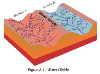
The term drainage describes the river system of an area. Look at the physical map. You will notice that small streams flowing from different directions come together to form the main river, which ultimately drains into a large water body such as a lake or a sea or an ocean. The area drained by a single river system is called a drainage basin. A closer observation on a map will indicate that any elevated area, such as a mountain or an upland, separates two drainage basins. Such an upland is known as a water divide (Figure 3.1).


163 videos|485 docs|256 tests
Information about Test: Drainage - 2 Page
In this test you can find the Exam questions for Test: Drainage - 2 solved & explained in the simplest way possible. Besides giving Questions and answers for Test: Drainage - 2, EduRev gives you an ample number of Online tests for practice
163 videos|485 docs|256 tests
Download as PDF

How to Prepare for UPSC

Read our guide to prepare for UPSC which is created by Toppers & the best Teachers
Download free EduRev App
Track your progress, build streaks, highlight & save important lessons and more!