SSC CGL Exam  >  SSC CGL Tests  >  SSC CGL Tier 2 - Study Material, Online Tests, Previous Year  >  Prelims Map Based Questions - 7 - SSC CGL MCQ

Prelims Map Based Questions - 7 - SSC CGL MCQ


Test Description

20 Questions MCQ Test SSC CGL Tier 2 - Study Material, Online Tests, Previous Year - Prelims Map Based Questions - 7

Prelims Map Based Questions - 7 for SSC CGL 2024 is part of SSC CGL Tier 2 - Study Material, Online Tests, Previous Year preparation. The Prelims Map Based Questions - 7 questions and answers have been prepared according to the SSC CGL exam syllabus.The Prelims Map Based Questions - 7 MCQs are made for SSC CGL 2024 Exam. Find important definitions, questions, notes, meanings, examples, exercises, MCQs and online tests for Prelims Map Based Questions - 7 below.
Solutions of Prelims Map Based Questions - 7 questions in English are available as part of our SSC CGL Tier 2 - Study Material, Online Tests, Previous Year for SSC CGL & Prelims Map Based Questions - 7 solutions in Hindi for SSC CGL Tier 2 - Study Material, Online Tests, Previous Year course. Download more important topics, notes, lectures and mock test series for SSC CGL Exam by signing up for free. Attempt Prelims Map Based Questions - 7 | 20 questions in 25 minutes | Mock test for SSC CGL preparation | Free important questions MCQ to study SSC CGL Tier 2 - Study Material, Online Tests, Previous Year for SSC CGL Exam | Download free PDF with solutions
Prelims Map Based Questions - 7 - Question 1

Consider the following statements regarding Sinai Peninsula:

  1. Sinai Peninsula located in the Asian part of Egypt between the Mediterranean Sea to the north, and the Red Sea to the south.
  2. It shares maritime or territorial boundary with Israel, Jordan and Gaza Strip.

Which of the above statement/s is/are correct?

Detailed Solution for Prelims Map Based Questions - 7 - Question 1

Sinai Peninsula

  • Sinai Peninsula located in the Asian part of Egypt between the Mediterranean Sea to the north, and the Red Sea to the south. The Sinai Peninsula is defi ned by the Suez Canal and the Gulf of Suez in west and the Gulf of Aqaba in south east.
  • Countries with international borders to Sinai are Palestinian territories (Gaza Strip) and Israel, Egypt shares maritime borders in the Sinai with Jordan and Saudi Arabia.
Prelims Map Based Questions - 7 - Question 2

Aral Sea is enclosed between which of the following two countries?

Detailed Solution for Prelims Map Based Questions - 7 - Question 2

Option (c) is correct: Aral Sea is enclosed between Uzbekistan and Kazakhstan.

Aral Sea

  • Once the fourth-largest freshwater lake in the world, the Aral Sea today is a tenth of its original size.
  • The North Aral Sea – the top half of the body of water – lies in Kazakhstan. The South Aral Sea, which consist of a strip of water in the west and a dried-out basin in the east, sits in Uzbekistan.
1 Crore+ students have signed up on EduRev. Have you? Download the App
Prelims Map Based Questions - 7 - Question 3

Consider the following statements:

  1. Dardanelles Strait links Sea of Marmara with Aegean Sea.
  2. The Aegean is located between between the mainlands of Greece,Bulgaria and Turkey.

Which of the above statement/s is/are correct?

Detailed Solution for Prelims Map Based Questions - 7 - Question 3

Statement 2 is incorrect: The Aegean is located between the mainland of Greece and Turkey, respectively.

Dardanelles Strait and the Aegean Sea

  • Dardanelles is a narrow strait in northwestern Turkey linking the Aegean Sea with the Sea of Marmara.
  • The Aegean Sea is an elongated embayment of the Mediterranean Sea and an important natural feature of the Mediterranean region.
  • The Aegean is located between the southern Balkan and the Anatolian peninsulas, between the mainlands of Greece and Turkey, respectively. In the north, it is connected to the Marmara Sea and the Black Sea by the Dardanelles and the Bosporus.
Prelims Map Based Questions - 7 - Question 4

Which of the following Indian states shares a land boundary with Myanmar?

  1. Arunachal Pradesh
  2. Nagaland
  3. Manipur
  4. Tripura
  5. Mizoram

Select the correct answer using the code given below:

Detailed Solution for Prelims Map Based Questions - 7 - Question 4

Option (d) is correct: Myanmar is bordered in the northwest by the Chittagong Division of Bangladesh and the Mizoram, Manipur, Nagaland and Arunachal Pradesh states of India.

Prelims Map Based Questions - 7 - Question 5

Arrange the following mountain passes from west to east direction?

  1. Jelep La
  2. Bum La
  3. Naku La
  4. Nathu La

Select the correct answer using the code given below:

Detailed Solution for Prelims Map Based Questions - 7 - Question 5

Naku La

  • Indian Army and the Chinese PLA clashed at Naku La in northern Sikkim on 20 January. According to the Indian Army spokesman, there was a “minor faceoff ” and the issues were resolved “by local commanders as per established protocols.” India has acknowledged that no weapons were used and that there had been injuries on both sides, but they were “insignifi cant and minor.”
Prelims Map Based Questions - 7 - Question 6

The Tsari Chu valley, in news recently, is situated in which of the following states/UTs?

Detailed Solution for Prelims Map Based Questions - 7 - Question 6

Option (c) is correct: The Tsari Chu valley is in Arunachal Pradesh.

Prelims Map Based Questions - 7 - Question 7

A Shitalakshya River is a distributary of which of the following river?

Prelims Map Based Questions - 7 - Question 8

Which of the following pairs is/are correctly matched?

Select the correct answer using the code given below:
Detailed Solution for Prelims Map Based Questions - 7 - Question 8

Pair 1 is incorrectly matched: Ken-Betwa  - Uttar Pradesh and Madhya Pradesh

Pair 3 is incorrectly matched: Par-TapiNarmada – Maharashtra, and Gujarat

Prelims Map Based Questions - 7 - Question 9

Which of the following countries fall in Golden Triangle?

Detailed Solution for Prelims Map Based Questions - 7 - Question 9

Option (a) is correct: Golden triangle comprises of Laos, Thailand and Myanmar.

Prelims Map Based Questions - 7 - Question 10

Which of the following island nations form the “Vanilla Islands” grouping?

  1. Madagascar
  2. Maldives
  3. Mauritius
  4. Chagos Archipelago
  5. Kerguelen Islands 6. Mayotte

Select the correct answer using the code given below:

Prelims Map Based Questions - 7 - Question 11

The Atal Tunnel has been inaugurated recently. Consider the following statements regarding Atal Tunnel:

  1. The tunnel will reduce the distance between Manali and Ladhak and will be operational throughout the year.
  2. The tunnel is built with ultra-modern specifi cations in the Pir Panjal range of Himalayas.

Which of the above statement/s is/are correct?

Detailed Solution for Prelims Map Based Questions - 7 - Question 11

Statement 1 is incorrect: The tunnel will reduce the distance between Manali and Leh.

Prelims Map Based Questions - 7 - Question 12

Consider the following islands:

  1. Paracel Islands
  2. Pratas Islands
  3. Spratly Islands
  4. Senkaku Islands

If one is travelling from South China Sea to East China Sea, arrange the following islands one will encounter in sequential order and select the correct option from the codes given below:

Detailed Solution for Prelims Map Based Questions - 7 - Question 12

Option (a) is the correct: Spratly IslandsParacel Islands-Pratas Islands-Senkaku Islands

Prelims Map Based Questions - 7 - Question 13

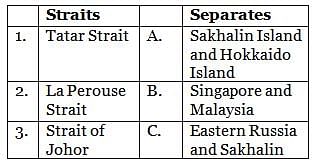
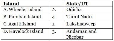
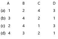
Match the following correctly:

Select the correct option from the codes given below:

Prelims Map Based Questions - 7 - Question 14

Katchall Island, seen in news recently, is located in:

Detailed Solution for Prelims Map Based Questions - 7 - Question 14

Katchall Islan

  • An Indian Coast Guard (ICG) ship has towed away a tanker, containing 910 tonnes of bunker fuel, from waters close to ecosensitive Katchall Island in the Nicobar archipelago, towards which it was drifting after a total power failure.
  • The Dubai-bound ‘MT Anasthasia-1’, with 24 crew members aboard, was posing a danger of running aground, risking oil spillage in the island, after experiencing total power failure since November 19.
  • In a swift sea-air coordinated operation on November 22, a Coast Guard team from ICG multi-mission vessel ‘Vishwast’ boarded the 243 m-long tanker, repaired its systems and towed it to safe water.
Prelims Map Based Questions - 7 - Question 15

Sigur Plateau is located in the state of:

Detailed Solution for Prelims Map Based Questions - 7 - Question 15

Sigur Plateau

  • The Supreme Court appointed conservationist Nandita Hazarika as Member of a Technical Committee constituted by it on October 14 last year to hear complaints by land owners against the action taken by the Nilgris Collector, which included “arbitrary variance in acreage of the elephant corridor.”
  • On October 14, the top court upheld the Tamil Nadu government’s authority to notify an ‘elephant corridor’ and protect the migratory path of the animals through the Nilgiri biosphere reserve, the largest protected forest area in India, spanning across Tamil Nadu, Karnataka and Kerala.
  • The corridor is situated in the ecologically fragile Sigur plateau.  Sigur Plateau is a plateau in the north and east of Nilgiri District in the Nilgiri Hills of Tamil Nadu.
  • It connects the Western and the Eastern Ghats and sustains elephant populations and their genetic diversity.
  • It has the Nilgiri Hills on its southwestern side and the Moyar River Valley on its northeastern side. The elephants cross the plateau in search of food and water.
Prelims Map Based Questions - 7 - Question 16

Match the following:

Select the correct answer using the code given below:

Detailed Solution for Prelims Map Based Questions - 7 - Question 16

Prelims Map Based Questions - 7 - Question 17

Consider the following statements:

  1. Shinkun La Tunnel is the world’s longest highaltitude tunnel.
  2. It is constructed by Border Roads Organization (BRO).

Which of the above statements is/are correct?

Detailed Solution for Prelims Map Based Questions - 7 - Question 17

Statement 2 is incorrect: It will be constructed by National Highways & Infrastructure Development Corporation Limited (NHIDCL) under Ministry of Road, Transport & Highways.

Prelims Map Based Questions - 7 - Question 18

Arrange the following glaciers in the order north to south:

  1. Machoi
  2. Zemu
  3. Pindari
  4. Siachen

Select the correct answer using the code given below:

Prelims Map Based Questions - 7 - Question 19

“Crimea” is situated between which of the following sea(s)?

Detailed Solution for Prelims Map Based Questions - 7 - Question 19

Option (a) is correct: Crimea is situated between Black sea and Sea of Azov.

Prelims Map Based Questions - 7 - Question 20

Which of the following statements about Feni River is/are correct?

  1. It is a trans-boundary river which originates in Bangladesh and enters India before fl owing into Bay of Bengal
  2. Muhuri River is its right bank tributary.

Select the correct answer using the code given below:

Detailed Solution for Prelims Map Based Questions - 7 - Question 20

Statement 1 is incorrect: It is a transboundary river which originates in South Tripura district and fl ows through Sabroom town and then enters Bangladesh.

1365 videos|1312 docs|1010 tests
Information about Prelims Map Based Questions - 7 Page
In this test you can find the Exam questions for Prelims Map Based Questions - 7 solved & explained in the simplest way possible. Besides giving Questions and answers for Prelims Map Based Questions - 7, EduRev gives you an ample number of Online tests for practice

Top Courses for SSC CGL

Download as PDF

Top Courses for SSC CGL