UGC NET Exam  >  UGC NET Tests  >  UGC NET Mock Test Series 2024  >  UGC NET Paper 2 Geography Mock Test - 3 - UGC NET MCQ

UGC NET Paper 2 Geography Mock Test - 3 - UGC NET MCQ


Test Description

30 Questions MCQ Test UGC NET Mock Test Series 2024 - UGC NET Paper 2 Geography Mock Test - 3

UGC NET Paper 2 Geography Mock Test - 3 for UGC NET 2024 is part of UGC NET Mock Test Series 2024 preparation. The UGC NET Paper 2 Geography Mock Test - 3 questions and answers have been prepared according to the UGC NET exam syllabus.The UGC NET Paper 2 Geography Mock Test - 3 MCQs are made for UGC NET 2024 Exam. Find important definitions, questions, notes, meanings, examples, exercises, MCQs and online tests for UGC NET Paper 2 Geography Mock Test - 3 below.
Solutions of UGC NET Paper 2 Geography Mock Test - 3 questions in English are available as part of our UGC NET Mock Test Series 2024 for UGC NET & UGC NET Paper 2 Geography Mock Test - 3 solutions in Hindi for UGC NET Mock Test Series 2024 course. Download more important topics, notes, lectures and mock test series for UGC NET Exam by signing up for free. Attempt UGC NET Paper 2 Geography Mock Test - 3 | 100 questions in 120 minutes | Mock test for UGC NET preparation | Free important questions MCQ to study UGC NET Mock Test Series 2024 for UGC NET Exam | Download free PDF with solutions
UGC NET Paper 2 Geography Mock Test - 3 - Question 1

Which of these layers of the atmosphere is composed of the ozone layer which is responsible for absorbing ultraviolet (UV) light?

Detailed Solution for UGC NET Paper 2 Geography Mock Test - 3 - Question 1

The ozone layer is primarily located in the stratosphere, which is the second major layer of Earth's atmosphere.

Key Points

  •  Ozone molecules in the stratosphere absorb and block a significant portion of the sun's ultraviolet (UV) radiation.
  • This absorption of UV light is crucial for protecting life on Earth from the harmful effects of excessive UV radiation.

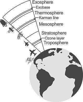
Additional InformationEarth's atmosphere is divided into several layers, each with distinct characteristics. From the surface of the Earth going outward, the main layers are:

  • Troposphere: The layer closest to the Earth's surface where weather events occur. It contains approximately 75% of the atmosphere's mass and is where we live and experience weather phenomena.
  • Stratosphere: Above the troposphere, this layer contains the ozone layer, which absorbs and scatters ultraviolet solar radiation. Commercial jet aircraft often fly in the lower stratosphere.

  • Mesosphere: Above the stratosphere, temperatures decrease with altitude in this layer. It is where most meteorites burn up upon entering the Earth's atmosphere.

  • Thermosphere: Characterized by a rapid increase in temperature with height due to the absorption of high-energy solar radiation. The northern and southern lights (auroras) occur in the thermosphere.

  • Exosphere: The outermost layer where the atmosphere gradually transitions into space. It contains very few gas molecules, and its upper boundary is not well-defined.

These layers collectively play essential roles in regulating temperature, weather patterns, and protecting life on Earth from harmful solar radiation.

UGC NET Paper 2 Geography Mock Test - 3 - Question 2

Western disturbances are extratropical storms that bring sudden winter rain to the northern parts of India. They originate in ______.

Detailed Solution for UGC NET Paper 2 Geography Mock Test - 3 - Question 2

The correct answer is the Mediterranean Sea.

Key PointsWestern disturbances are extratropical storms that bring sudden winter rain to the northern parts of India. They originate in the Mediterranean Sea

Western Disturbances

  • Western Disturbances form in the mid-latitude area, situated north of the Tropic of Cancer. This is why they are referred to as mid-latitude storms or extra-tropical storms
  • Western Disturbances are low-pressure systems, embedded in western winds (westerlies)  that flow from west to east.

Arrival in India

  • Western Disturbances begin is a low-pressure system that originates in the Mid-latitude region near the Atlantic Ocean and Europe.
  • The low pressure typically forms over the Mediterranean Sea and travels over Iran, Iraq,  Afghanistan, and Pakistan before entering India loaded with moisture.
  • These moisture-laden western disturbances eventually come up against the Himalayas and get blocked, as a consequence, the moisture gets trapped and precipitation is shared in the form of snow and rain over Northwest India and other parts of North India. 
  • An average of 4-5 western disturbances form during the winter season and the rainfall distribution and amount varies with every western disturbance.
  • The word 'Western' refers to the direction from which they originate in India.
  • The word 'disturbance' is used because the air within the low-pressure systems tends to be unstable or disturbed.
  • When western disturbances become more intense in the Indian Region, they can extend even up to 15 degrees north, resulting in rainfall up to north Maharashtra,  Gujarat, and the entire Madhya Pradesh to the south.

Impact

  • Western Disturbances are the cause of most winter and pre-monsoon season rainfall across North-West India.
  • This phenomenon is usually associated with a cloudy sky, higher night temperatures, and unusual rain.
  • It is estimated that India gets close to 5-10% of its total annual rainfall from western disturbances.
  • In winter, western winds bring moderate to heavy rain in low-lying areas and heavy snow to mountainous areas of the Indian subcontinent. 
  • India is a rain-dependent country and while the southwest monsoon covers most of India, parts of North India don’t get much rain from it.
  • These regions depend upon snow and rain from western disturbances during the winter season from November to March.
  • Precipitation during the winter season has great importance in agriculture particularly for rabi crops including wheat, which is one of the most important Indian crops.
  • They start declining after winter.
  • During the summer months of April and May, they move across North India and at times help in the activation of monsoon in certain parts of northwest India.
  • During the monsoon season, western disturbances may occasionally cause dense clouding and heavy precipitation.
  • Weak western disturbances are associated with crop failure and water problems across north India.
  • Strong western disturbances can help residents, farmers and governments avoid many of  the problems associated with water scarcity.

Additional Information

  • The Mediterranean Sea is located between Eurasia and Africa, mostly surrounded by land.
  • It shares borders with 21 countries: Albania, Algeria, Bosnia and Herzegovina, Croatia, Cyprus, Egypt, France, Greece, Israel, Italy, Lebanon, Libya, Malta, Monaco, Montenegro, Morocco, Slovenia, Spain, Syria, Tunisia, and Turkey.
  • To the west, it connects to the Atlantic Ocean via the Strait of Gibraltar.
  • To the east, it is linked to the Black Sea through the Dardanelles Straits.
  • To the south, it is connected to the Red Sea through the Suez Canal.
  • The Nile River in Africa drains into the Mediterranean Sea.

1 Crore+ students have signed up on EduRev. Have you? Download the App
UGC NET Paper 2 Geography Mock Test - 3 - Question 3

Carbon dioxide contributes in trapping the heat radiated from the earth. It is known called

Detailed Solution for UGC NET Paper 2 Geography Mock Test - 3 - Question 3

Carbon dioxide contributes in trapping the heat radiated from the earth. It is known called green house effect.

Key Points Green house effect: 

  • A greenhouse stays warm inside, even during the winter. In the daytime, sunlight shines into the greenhouse and warms the plants and air inside.
  • At nighttime, it's colder outside, but the greenhouse stays pretty warm inside.
  • That's because the glass walls of the greenhouse trap the Sun's heat.
  • The greenhouse effect works much the same way on Earth.
  • Gases in the atmosphere, such as carbon dioxide, trap heat similar to the glass roof of a greenhouse.
  • These heat-trapping gases are called greenhouse gases.
  • Human activities are changing Earth's natural greenhouse effect.
  • Burning fossil fuels like coal and oil puts more carbon dioxide into our atmosphere.

Some of the infrared radiation from the Sun passes through the atmosphere, but most is absorbed and re-emitted in all directions by greenhouse gas molecules and clouds. The effect of this is to warm the Earth's surface and the lower atmosphere.

UGC NET Paper 2 Geography Mock Test - 3 - Question 4

Study the following pairs (P, Q, R, S) with respect to GPS receivers used in GPS surveys and select the correct answer based on the matching.

P : GPS receivers : L-band radio processor

Q : Self-contained GPS receivers : Also known as 'GPS mice'

R : Dual-frequency receivers : Survey grade GPS, position accuracy according to differential correction within sub-centimetre

S : Carrier phase receivers : GPS receivers with 10 to 30 cm position accuracy with differential correction

Detailed Solution for UGC NET Paper 2 Geography Mock Test - 3 - Question 4

Explanation

GPS Receivers -  A GPS receiver is an L-band radio processor. It processes the signal broadcast by GPS satellites, solves the equations for navigation so that user can easily compute their position, precise time & velocity.

Types of GPS Receivers

  1. On the basis of features
  2. On the basis of level of accuracy


Types of GPS Receivers on the basis of features-

  • Not-self-contained receivers: also known as 'GPS mice'. These are without screen and are need to be connected to a computer for the purpose of visualization of real position of GPS receiver.Bluetooth (wireless) can be the link of connection between the GPS and computer. This type is best used in car-navigation systems.
  • Self contained receivers: have a screen and is integrated with the computer itself. Sometimes. additional features e.g. electronic compass, barometer etc. are found in this type. It is primarily used in boating and aviation.
  • Sophisticated receivers: are meant for professional use. e.g. in the field of mapping & GIS. transportation safety, crop & agriculture etc. Though the working principle remains the same as others, the only important difference is its storage capacity and higher accuracy, which helps to store a larger amount of data that can be treated later in the office.

Types of GPS Receivers on the basis of different levels of accuracy-

  • C/A Code receivers: These receivers have the accuracy of 1 to 5 m related to position and differential correction so that getting an occupation time of 5 seconds. The recent advancement in the GPS receiver design now enables it to provide sub-meter accuracy down to 30 cm.
  • Carrier Phase receivers: These receivers provide 10-30 cm GPS position accuracy with differential correction. The distance from the receiver to the satellite is measured by determining the total number of waves which supports the C/A code signal, which is more accurate and takes about 5 minutes of the occupation time.
  • Dual-Frequency receivers: provide GPS position accuracy according to differential correction within sub centimeter & accuracy according to survey grade. These receivers are presented with the signals from satellites on the basis of two frequencies at the same time. The use of two frequencies will help in omission of atmospheric and other errors and thus improving the accuracy.
UGC NET Paper 2 Geography Mock Test - 3 - Question 5
Which of the following statements is incorrect regarding endogenic processes inside the earth?
Detailed Solution for UGC NET Paper 2 Geography Mock Test - 3 - Question 5

The correct answer is None of the above.

Key Points

  • The endogenic and exogenic forces can cause changes in the configuration of the surface of the earth and refer to as geomorphic processes. 
    • The energy originating from within the earth is the main force behind endogenic geomorphic processes.
    • This energy is mostly produced by rotational and tidal friction, radioactivity, and primordial heat from the origin of the earth.
    • This energy due to geothermal gradients and heat flow from within induces diastrophism and volcanism in the lithosphere.
  • The energy emanating from within the earth is the main force behind endogenic geomorphic processes.
  • The earth movements are mainly of two types: diastrophism and sudden movements
  • Diastrophism:
    • All processes that move, elevate or build up portions of the earth’s crust come under diastrophism. 
    • Diastrophism is further classified into orogenic (involving mountain buildings), epeirogenic (upliftment or warping of large parts of the earth's crust), earthquake, and plate tectonic activities.
  • Sudden movements:
    • They cause considerable deformation over a short span of time and may be of two types: earthquakes and volcanoes.
UGC NET Paper 2 Geography Mock Test - 3 - Question 6
Cloudy nights are warmer than clear nights because
Detailed Solution for UGC NET Paper 2 Geography Mock Test - 3 - Question 6

The correct answer is it acts as a hindrance to terrestrial radiation.

Key Points

  • Cloudy nights are warmer compared to clear cloudless nights, because clouds Reflect back the heat given off by earth.
  • The cloudy skies are like a blanket and the warmer air on the ground with us tries to leave and the clouds stop it from leaving.
  • Warmer air will always try to move up and it cannot do so because of the clouds. That's why you might notice that cloudy nights are warmer than clear nights.
  • If skies are clear, heat emitted from the earth\'s surface freely escapes into space, resulting in colder temperatures.
UGC NET Paper 2 Geography Mock Test - 3 - Question 7

The following item consists of two statements, statement I and statement II. Examine these two statements carefully and select the correct answer from the code given below.

Statement I:

Summer is the favourable season for lumbering activity.

Statement II:

The Siberian region has a thriving lumbering industry.

Detailed Solution for UGC NET Paper 2 Geography Mock Test - 3 - Question 7

The Correct Answer is Option 4.

Important Points

  • Lumbering is defined as the felling of economic trees in the forest, which can be used for domestic, industrial, or commercial purposes.
  • Factors that favour lumbering :
    • Limited species forests such as coniferous forests.
    • Lumbering is normally carried out in the winter when the sap ceases to flow. This makes felling much simpler. Hence, statement I is incorrect.
  • The snow-covered ground makes logging and haulage [commercial transport of goods] a relatively easy job.
  • The logs are dragged to the rivers and float to the saw-mills downstream when the rivers thaw [unfreeze] in spring. This has greatly assisted the lumbering industry in eastern Canada and Sweden.
  • Cheap hydroelectricity for driving the saw-mills is harnessed in the mountainous uplands of North America and Europe and have greatly assisted the lumbering industry.
  • Factors hindering Lumbering :
    • High species diversity as seen in Equatorial and Tropical forests.
    • The heaviness of the tropical hardwoods makes them unable to float in rivers, thus requiring the development of various modes of transport in the forests. 
  • It is the most important occupation of the Siberian type of climate. Hence, statement II is correct.
UGC NET Paper 2 Geography Mock Test - 3 - Question 8

Who among the following is known as the '‘father of exceptionalism’?

Detailed Solution for UGC NET Paper 2 Geography Mock Test - 3 - Question 8

Key Points

  •  The scholar who influenced the geographical scholarship in the preclassical period was Immanuel Kant (1724 – 1804).
  • His early works like ‘General Natural History and the Theory of the Heavens’ (1755) did not have much to do with geography and was more related to speculative astronomy.
  • Immanuel Kant may rightly be regarded as the ‘father of exceptionalism’ as he was opposed to generalisations and believed that history and geography were

methodologically different from the other sciences as, they were concerned with the study of the unique and the ‘exceptional.’

Additional Information

  •  Humboldt:  Alexander von Humboldt (1769-1859) was a German naturalist, explorer, and geographer who is considered to be the father of modern geography.
  • Ritter: Carl Ritter (1779-1859) was a German geographer and founder of modern scientific geography.  The principle of unity in diversity was the fundamental principle developed by Ritter
  • Ratzel: Friedrich Ratzel (1844-1904) was a German geographer, ethnologist, and anthropologist who is considered to be the father of political geography.
UGC NET Paper 2 Geography Mock Test - 3 - Question 9

What did Ratzel compare a state to in his work "Political Geography"

Detailed Solution for UGC NET Paper 2 Geography Mock Test - 3 - Question 9

Answer: 4) A living Organism.

Key Points

  • Fredrich Ratzel is the founder of modern human geography.
  • He has extended significant contribution in the development of human geography.
  • Ratzel wrote an epic named “Anthropogeography”.
  • In his work "Political Geography", Ratzel compared a state to a living organism. He believed that states, like living organisms, are born, grow, and eventually die.
  • He also believed that states, like living organisms, need to adapt to their environment in order to survive.
  • Ratzel's analogy between states and living organisms was controversial at the time, but it has since become a widely accepted concept in political geography. Today, it is common to refer to states as "political organisms" or "geopolitical entities".

Therefore, the correct answer is option 4) A living organism. Ratzel compared a state to a living organism in his work "Political Geography".

UGC NET Paper 2 Geography Mock Test - 3 - Question 10

Match the List - I with List - II and select the correct answer from the code given below:

Detailed Solution for UGC NET Paper 2 Geography Mock Test - 3 - Question 10

iii. Decomposition releases CH4 or methane.
iv. Transpiration releases Water vapour.
i. Respiration releases CO2 or carbon dioxide
ii. Photosynthesis releases O2 or oxygen.

Thus, the Correct answer is C.

UGC NET Paper 2 Geography Mock Test - 3 - Question 11
Which zone is referred to as the Zone of Comparative intensity depending on the intensity and frequency of earthquakes?
Detailed Solution for UGC NET Paper 2 Geography Mock Test - 3 - Question 11

The earthquakes that strike this zone are of moderate intensity of 6-6.5 . The extent of this zone runs to the south of the Himalayan zone and runs parallel to it. The earthquakes are quite devastating due to high density of population.

UGC NET Paper 2 Geography Mock Test - 3 - Question 12
Asthenosphere is a part of ______________.
Detailed Solution for UGC NET Paper 2 Geography Mock Test - 3 - Question 12

The correct answer is Earth's Mantle.

Key Points

  • Asthenosphere:
    • The asthenosphere is the denser, weaker layer beneath the lithospheric mantle.
    • It lies between about 100 kilometers (62 miles) and 410 kilometers (255 miles) beneath Earth's surface.
    • The temperature and pressure of the asthenosphere are so high that rocks soften and partly melt, becoming semi-molten.
    • The asthenosphere is generally more viscous than the lithosphere, and the lithosphere-asthenosphere boundary (LAB) is the point where geologists and rheologists, scientists who study the flow of matter mark the difference in ductility between the two layers of the upper mantle.

So, it is clear that the Asthenosphere is located beneath the crust and the crustal plates are moving over this layer.

UGC NET Paper 2 Geography Mock Test - 3 - Question 13

Which type of settlement pattern is having the following features?

1. narrow meandering streets and lanes

2. high population density

3. the high degree of nucleation

4. most common in India

Select the correct answer using the code given below.

Detailed Solution for UGC NET Paper 2 Geography Mock Test - 3 - Question 13

The correct answer is a Rectangular pattern.

Key Points

Rectangular pattern: 

  • The settlements with rectangular patterns have a high degree of nucleation.
  • More than 50% of the world's population lives in such settlements.
  • This pattern of settlement is most common in India.
  • This pattern of settlement is found where the land capability is high
  • The areas having this pattern of settlement have a high degree of clustering and high population density.
  • The shape of the cultivated land is rectangular.
  • Examples (India)
    • Most North Indian villages have rectangular patterns dominated by caste groups.
    • Ganga-Yamuna-Doab, Eastern Uttar Pradesh villages, Western Bihar villages.
  • Regions with high population density like well-planned settlements of Germany, Russia, China, Israel, France, etc. (these are the places with planned settlements)
  • The settlements with rectangular patterns have narrow meandering streets and lanes.
  • In the central part, the village headman or old Zamindar house with his own caste man has greater nucleation while away from the centre spacing between house increases.
UGC NET Paper 2 Geography Mock Test - 3 - Question 14

Consider the following statements:

1. Culture adapted to the dictates of Nature.

2. Culture is determined by Social Conditions.

Which of the above statement(s) is correct about Determinism?
Detailed Solution for UGC NET Paper 2 Geography Mock Test - 3 - Question 14
Environmental determinism
  • In the early stages of their interaction with their natural environment humans were greatly influenced by it. They adapted to the dictates of Nature.
  • This philosophy says that aspects of physical geography, particularly climate, influenced the psychological mind-set of individuals, which in turn defined the behaviour and culture of the society that those individuals formed. 
  • The core philosophy is that the supreme achievements of civilisation in any region were always bound up with a particular type of climate and variation in climate led to pulsations in the history and culture of the people.
  • These geographers who propound this theory say that the civilisations of Egyptians, Mesopotamians, Indus-valley, disappeared because of the climatic changes.
UGC NET Paper 2 Geography Mock Test - 3 - Question 15
The world's largest continental shelf extends ________ from the coast of Siberia into the Arctic Ocean.
Detailed Solution for UGC NET Paper 2 Geography Mock Test - 3 - Question 15

The correct answer is '1,500 km'.

Key PointsSiberian Shelf

  • The Siberian Shelf is a coastal shelf in the Arctic Ocean and is the largest continental shelf of the Earth, a part of the continental shelf of Russia.
  • It extends from the continent of Eurasia in the general area of North Siberia (hence the name) into the Arctic Ocean.
  • It stretches 1,500 kilometres (930 miles) offshore.
  • It is relatively shallow, with an average depth of 100 m.
  • A number of islands are within the shelf, including Wrangel Island, Novaya Zemlya, and the New Siberian Islands.
  • It is encompassed by the Kara Sea, Laptev Sea, and the East Siberian Sea, and respectively subdivided into the Kara Shelf, the Laptev Shelf and the East Siberian Shelf.
  • Eastwards it merges into the Chukchi Shelf (of the Chukchi Sea) shared by Eurasia and North America (i.e., by Russia and the United States).
  • Westwards it merges into the Barents Shelf of the Barents Sea.
  • According to the split of the high Arctic by the Lomonosov mid-ocean ridge into the Eurasian Basin and Amerasian Basin, the Siberian Shelf is split between the Eurasian Shelf and the Amerasian Shelf.

Thus, the correct answer is 1,500 km.

Additional InformationContinental Shelf

  • A continental shelf is a shelf of the earth underwater in an ocean or ocean, which is a part of a continent's elevation below sea level.
  • The depth of the water on the continental shelf decreases and from the end of the shelf, the depth starts increasing on the continental slope. This place is called the shelf break. Beyond this comes a zone of continental rise that transforms into an abyssal plain on the deep ocean floor.
  • During the ice ages, when some of the seawater accumulated in ice, the sea level fell and a large part of the continental shelf rose above the water and becomes the earth.
  • Continental Shelf depths are approximately the same throughout the world and are found at 140 m (460 ft).
  • This is an astonishing phenomenon, and geologists speculate that it may have been the surface of oceans around the world during the Ice Age.
UGC NET Paper 2 Geography Mock Test - 3 - Question 16

Match the following correctly:

Detailed Solution for UGC NET Paper 2 Geography Mock Test - 3 - Question 16

The correct answer is (a) - (iii), (b) - (iv), (c) - (ii), (d) - (i).
Key Points

UGC NET Paper 2 Geography Mock Test - 3 - Question 17
Geography studies the
Detailed Solution for UGC NET Paper 2 Geography Mock Test - 3 - Question 17

The correct answer is A and B.

Key Points

  • Spatial organization is the study of geography expressed in the pattern and process of phenomena. It is to understand the form or nature and cause of the areal differentiation or variation on the surface of the earth.
  • American Science Congress 1965 defined geography as the study of ‘Patterns and Processes’. This definition is an attempt to reinstate the past glory of time and space perspective in the study of the subject.
  • The concept of spatial organization talks about the spatial dimensions and manifestations of phenomena. The process is the temporal aspect of the result of a certain explicit expression.
  • The face of the earth is divided into various units/ regions/areas/ natural landscapes at times cultural and social landscapes based on areal differentiation, present a spatial synthesis. Spatial synthesis here concerns the ‘complex whole made up of several parts unified.
  • To study the spatial organization of the phenomena, geography sought to frame generalized laws through a nomothetic or law-formulating approach. The chorological science approach translated into regional geography while the spatial science approach through the methods of systematic science prelude the initiation of a systematic approach in geography.
  • Spatial integration expresses the opportunities for and level of (economic, cultural) interaction within and between areas and may reflect the willingness to cooperate.
  • It also indicates, for example, the level of connectivity between transport systems of different geographical scales.
  • Spatial integration is positively influenced by the presence of efficient administrative bodies, physical and functional complementarity between areas, and the absence of cultural and political controversies.
UGC NET Paper 2 Geography Mock Test - 3 - Question 18

The dust and ash material hurled from the volcanoes are termed as:

Detailed Solution for UGC NET Paper 2 Geography Mock Test - 3 - Question 18

The correct answer is Pyroclastic.

Key Points

  • Pyroclastic flows contain a high-density mix of hot lava blocks, pumice, ash, and volcanic gas. They move at very high speed down volcanic slopes, typically following valleys.
  • Pelean and Plinian eruptions are the most dangerous and explosive of the eruption types.
  • Pelean eruptions are named for the catastrophic eruption on the island of Martinique in the Caribbean Sea in 1902. The eruption and the pyroclastic flow that followed killed 29,000 people almost instantly.

Additional Information

  • Volcanoes:
    • A volcano is a vent or fissure in Earth’s crust through which lava, ash, rocks, and gases erupt.
  • The other types of volcanoes are Shield Volcanoes and Composite Volcanoes.
  • Shield volcanoes:
    • These are the largest of all the volcanoes on the earth.
    • These volcanoes are made up of basalt.
    • Eg: Hawaiian shield volcanoes.
  • Flood Basalt volcanoes:
    • These volcanoes discharge highly fluid lava that flows for long distances.
    • Most parts of the world are covered by thick basalt lava flows.
UGC NET Paper 2 Geography Mock Test - 3 - Question 19

In which layer the maximum part of the atmosphere (by mass) is found?

Detailed Solution for UGC NET Paper 2 Geography Mock Test - 3 - Question 19

The Correct Answer is Troposphere.

Key Points

  • Troposphere
    • The troposphere is the lowest portion of Earth’s atmosphere and contains approximately 80% of the atmosphere’s mass and 99% of its water vapor and aerosols.
    • The average depth of the troposphere is approximately 17 km in the middle latitudes.
    • The characteristic features of the Troposphere are its great density.
    • In addition to nitrogen and oxygen, carbon dioxide, and water vapor (nearly all of the water vapor contained in the atmosphere is concentrated in the troposphere) and numerous particles of various origin
    • It thickness of the Troposphere is maximum at the equator, deeper in the tropics, up to 20 km, and shallower near the polar regions, at 7 km in summer, and indistinct in winter.
    • In India, it is taken to be around 16 Kilometers.
    • The thickness of the troposphere and consequently the atmosphere is maximum at the equator.
    • Almost all clouds are found in the troposphere.

Additional Information

  • Stratosphere
    • It is the second layer of the atmosphere found above the troposphere.
    • It extends up to 50 km in height.
    • This layer is very dry as it contains little water vapour.
    • This layer provides some advantages for flight because it is above stormy weather and has steady, strong, horizontal winds.
    • The ozone layer is found in this layer.
    • The ozone layer absorbs UV rays and safeguards the earth from harmful radiation.
    • Stratopause separates Stratosphere and Mesosphere.
  • Mesosphere
    • It is the coldest of the atmospheric layers.
    • The mesosphere starts at 50 km above the surface of Earth and goes up to 85 km.
    • The temperature drops with altitude in this layer.
    • By 80 km it reaches -100 degrees Celsius.
    • Meteors burn up in this layer.
    • Mesopause separates Mesosphere and Thermosphere.
  • Thermosphere
    • This layer is found above Mesopause from 80 to 400 km.
    • Radio waves that are transmitted from the earth are reflected by this layer.
    • The temperature increases with height.
    • Satellites occur in this layer.
  • Exosphere
    • It is the outermost layer of the atmosphere.
    • The zone where molecules and atoms escape into space is mentioned as the exosphere.
    • It extends from the top of the thermosphere up to 10,000 km.

UGC NET Paper 2 Geography Mock Test - 3 - Question 20

Which of the following is true about Tropical Rain forest?

(A) These forest are called evergreen forests.

(B) The trees in these forests shed their leaves at different times of the year.

(C) Sal, Teak and Shisham are important trees of these forests.

(D) These forests are called monsoon forests.

Choose the correct option

Detailed Solution for UGC NET Paper 2 Geography Mock Test - 3 - Question 20

The correct answer for the given question is option 1, which includes options (A) and (B).

Key Points

  • Tropical rainforests are called evergreen forests because they have high annual rainfall and consistent temperature, which allows the trees to retain their leaves throughout the year.
  • The trees in tropical rainforests do not shed their leaves at the same time, but rather at different times of the year, which is known as deciduousness.
  • Sal, Teak, and Shisham are not important trees in tropical rainforests. These trees are commonly found in dry deciduous forests and savannas.
  • Tropical rainforests are not called monsoon forests. Monsoon forests are a type of tropical seasonal forest that experiences a distinct wet and dry season.

Additional Information

Additional information about the other options mentioned in the question are: - Option 2, which includes options (A) and (C), is incorrect because Sal, Teak, and Shisham are not important trees in tropical rainforests. - Option 3, which includes options (B) and (D), is incorrect because tropical rainforests are not called monsoon forests. - Option 4, which includes options (C) and (D), is incorrect because Sal, Teak, and Shisham are not important trees in tropical rainforests and tropical rainforests are not called monsoon forests. Key points for the correct options are: - Tropical rainforests are called evergreen forests because they have high annual rainfall and consistent temperature. - The trees in tropical rainforests do not shed their leaves at the same time, but rather at different times of the year. - Tropical rainforests are characterized by high biodiversity and complex ecosystems. - Tropical rainforests are vital for regulating the global climate and providing ecosystem services such as carbon storage, water cycling, and habitat for wildlife.

UGC NET Paper 2 Geography Mock Test - 3 - Question 21

Select the ocean currents related to the Indian Ocean

Detailed Solution for UGC NET Paper 2 Geography Mock Test - 3 - Question 21

Currents of the Indian Ocean:

  • The pattern of circulation of ocean currents in the Indian Ocean differs from the general pattern of circulation in the Atlantic and the Pacific Oceans.
  • This is because the Indian Ocean is blocked by the continental masses in the north.
  • The general pattern of circulation in the southern hemisphere of the Indian Ocean is anti-clockwise as that of the other oceans.
  • In the northern hemisphere, there is a clear reversal of currents in the winter and summer seasons.
  • These are completely under the influence of the seasonal changes of monsoon winds.

Key Points

Indian Ocean: northern hemisphere during winter

  • During winter, Sri Lanka divides the currents of the Arabian Sea from those of the Bay of Bengal.
  • The North-East Monsoon Drift flows westward just south of Sri Lanka with a countercurrent flow between it and the South Equatorial Current.
  • During the winter season, in the northern section, the Bay of Bengal and the Arabian Sea are under the influence of North East Monsoon Winds.
  • These North East Monsoon winds drive the waters of the Bay of Bengal and the Arabian Sea westward to circulate in an anti-clockwise direction.

Indian Ocean: northern hemisphere during summer

  • In summer, the northern part comes under the influence of the South West Monsoon.
  • It results in an easterly movement of water in the Bay of Bengal and the Arabian Sea in a clockwise direction.
  • This current is called the South West Monsoon Drift.
  • In the Indian Ocean, the summer currents are more regular than those of the winter.

Indian Ocean: southern hemisphere

  • In the southern part, the South Equatorial Current which flows from east to west is strengthened by its corresponding current of the Pacific Ocean.
  • It then turns southward along the coast of Mozambique in Africa.
  • A part of this current moving in between the African mainland and Mozambique is called the warm Mozambique Current.
  • After the confluence of these two parts, the current is called Agulhas Current.
  • Agulhas Current merges with the West Wind Drift when it crosses the Indian Ocean.
  • A branch of this merged current flows along the western coast of Australia as cold West Australian Current.
  • It later joins with the South Equatorial Current to complete the circuit.

Thus, the Indian Ocean currents are West Australian Current, Agulhas Current, South West Monsoon Drift.

UGC NET Paper 2 Geography Mock Test - 3 - Question 22

Statement I: The Doldrums is a low-pressure area around the Equator where the prevailing winds are calm

Statement II: Low pressure is caused by the heat at the Equator which makes the air rise and travel both Northwards and Southwards

Detailed Solution for UGC NET Paper 2 Geography Mock Test - 3 - Question 22

The correct answer is 1.

Key Points

  • Equatorial Low-Pressure Belt or ‘Doldrums’-
    • It is located in the vicinity of the geographical equator between 5° North and 5° South latitude.
    • Width may vary between 5°N and 5°S and 20°N and 20°S.
    • This belt is also called the Doldrums, because of the extremely calm air movements. Hence, statement 1 is correct.
    • It is the region of convergence of trade winds blowing equatorward from the sub-tropical belts of high pressure in the northern and southern hemispheres. Hence, statement 2 is correct and Statement 2 is the correct explanation of Statement 1.
    • The position of the belt varies with the apparent movement of the Sun.

Important Points

  • Formation of Equatorial Low-Pressure Belt
    • As this region lies along the equator, it receives the highest amount of insolation.
    • Due to intense heating, the air gets warmed up and rises over the equatorial region (convection).
    • Whenever there is a vertically upward movement of air, the region at the surface will be at low pressure. Thus the belt along the equator is called the equatorial low-pressure belt.
UGC NET Paper 2 Geography Mock Test - 3 - Question 23
Which of the following option is correct regarding Penck’s Theory?
Detailed Solution for UGC NET Paper 2 Geography Mock Test - 3 - Question 23

The German Geomorphologist, Walther Penck proposed that the geomorphic forms are an expression of the phase and rate of uplift and in relation to the rate of degradation or erosion. This explains that the interaction between upliftment and degradation are always coexistent. These are the basic premises of the Penckian model. Accordingly, Primarumpf is referred to as the formation which can be seen before the stage of upliftment. Similarly, just like the other theories, after continued upliftment and erosional factors, the landscape gets reduced to the low plain known as endrumpf. This theory contrasts with the Davisian cycle of erosion.

UGC NET Paper 2 Geography Mock Test - 3 - Question 24

Given below are two statements. One is labelled as Assertion (A) and the other is labelled as Reason (R).

Assertion(A)- Standard Deviation is superior than the other measures of dispersion.

Reason(R)- It possesses almost all the requisites of a good measure of dispersion.

Select the correct answer from options given below:

Detailed Solution for UGC NET Paper 2 Geography Mock Test - 3 - Question 24

Standard Deviation is truly superior than the other measures of dispersion as it contains all the properties of a good measure of dispersion. Some properties are:- 1. It is rigidly defined. 2. It is based on all the observations as even if one observation is changed, S.D. changes. Range and Quartile Deviation do not possess this property. 3. Although not so simple as range or Q.D., the calculation of S.D. is not so difficult and doesn’t require any special technique. 4. It is amenable to algebraic treatment.

UGC NET Paper 2 Geography Mock Test - 3 - Question 25
Sir Isaac Newton has improvised on the work of
Detailed Solution for UGC NET Paper 2 Geography Mock Test - 3 - Question 25

Varenius is famous for his book Geographica Generalis. It is divided into three sections of absolute geography, comparative geography and relative geography. It is head as an important addition to the knowledge about comparative and scientific geography. Sir Isaac Newton made a lot of improvisation on the 1672 Cambridge edition of this book.

UGC NET Paper 2 Geography Mock Test - 3 - Question 26

Given below are two statements. One is labelled as Assertion (A) and the other is labelled as Reason (R).

Assertion (A): Development in ICT has led to increase in technical field of education in India.

Reason (R) : There has been increase in investment in ICT sector in India.

Select the correct answer from options given below:

Detailed Solution for UGC NET Paper 2 Geography Mock Test - 3 - Question 26

The Information and communication is a sector developing at a stupendous rate globally. The Foreign Direct Investment in India has been done most in the ICT sector. Thus, investment in the area has increased considerably. This has led to requirement of skilled workforce for ICT. So, there has been progress in technical education in India, specifically ICT sector due to enormous employment opportunities. Thus, (R) is the correct explanation of (A).

UGC NET Paper 2 Geography Mock Test - 3 - Question 27
Among these, which one of the following variables will the slope character and formation depend on?
Detailed Solution for UGC NET Paper 2 Geography Mock Test - 3 - Question 27

The slope characteristics will depend on these three factors along with Base-level changes, geomorphological changes, vegetation cover, tectonic movement. Rock types influence the slope angle directly and through its control on the nature of superficial deposits. Resistant rocks normally produce slopes that are steeper than these on weak rock types. Climate has been known to influence weathering and runoff processes, hence it can be said that it also influences slope form. But there is not much evidence regarding this factor.

UGC NET Paper 2 Geography Mock Test - 3 - Question 28

Match List-I with List-II and select the correct answer from the codes given below :

Choose the correct options from the following:

Detailed Solution for UGC NET Paper 2 Geography Mock Test - 3 - Question 28

Universal Geography is the work of Elisee Recule published in the year 1894

La reform Sociale is the work by Le play published in the year 1864

Du serment decisoir is the work by Paul de Rousiers published in the year 1878

Histoire de France is the work of Edmond demolins published in the year 1879

UGC NET Paper 2 Geography Mock Test - 3 - Question 29
The Chaudhary Charan Singh Airport is located in
Detailed Solution for UGC NET Paper 2 Geography Mock Test - 3 - Question 29

Chaudhary Charan Singh International Airport is located in Uttar Pradesh and serves Lucknow. It was earlier known as Amausi airport.

UGC NET Paper 2 Geography Mock Test - 3 - Question 30

The winds that blow from the sea contain …………….. moisture

Detailed Solution for UGC NET Paper 2 Geography Mock Test - 3 - Question 30

The winds that blow from the sea contain more moisture. The wind will blow from the higher pressure over the water to lower pressure over the land causing the sea breeze. The sea breeze strength will vary depending on the temperature difference between the land and the ocean. At night, the roles reverse. The air over the ocean is now warmer than the air over the land.

View more questions
16 docs|120 tests
Information about UGC NET Paper 2 Geography Mock Test - 3 Page
In this test you can find the Exam questions for UGC NET Paper 2 Geography Mock Test - 3 solved & explained in the simplest way possible. Besides giving Questions and answers for UGC NET Paper 2 Geography Mock Test - 3, EduRev gives you an ample number of Online tests for practice

Top Courses for UGC NET

Download as PDF

Top Courses for UGC NET