UGC NET Exam  >  UGC NET Tests  >  UGC NET Mock Test Series 2024  >  UGC NET Paper 2 Geography Mock Test - 5 - UGC NET MCQ

UGC NET Paper 2 Geography Mock Test - 5 - UGC NET MCQ


Test Description

30 Questions MCQ Test UGC NET Mock Test Series 2024 - UGC NET Paper 2 Geography Mock Test - 5

UGC NET Paper 2 Geography Mock Test - 5 for UGC NET 2024 is part of UGC NET Mock Test Series 2024 preparation. The UGC NET Paper 2 Geography Mock Test - 5 questions and answers have been prepared according to the UGC NET exam syllabus.The UGC NET Paper 2 Geography Mock Test - 5 MCQs are made for UGC NET 2024 Exam. Find important definitions, questions, notes, meanings, examples, exercises, MCQs and online tests for UGC NET Paper 2 Geography Mock Test - 5 below.
Solutions of UGC NET Paper 2 Geography Mock Test - 5 questions in English are available as part of our UGC NET Mock Test Series 2024 for UGC NET & UGC NET Paper 2 Geography Mock Test - 5 solutions in Hindi for UGC NET Mock Test Series 2024 course. Download more important topics, notes, lectures and mock test series for UGC NET Exam by signing up for free. Attempt UGC NET Paper 2 Geography Mock Test - 5 | 100 questions in 120 minutes | Mock test for UGC NET preparation | Free important questions MCQ to study UGC NET Mock Test Series 2024 for UGC NET Exam | Download free PDF with solutions
UGC NET Paper 2 Geography Mock Test - 5 - Question 1

Who propounded the concept of 'Geographical Pivot of History'?

Detailed Solution for UGC NET Paper 2 Geography Mock Test - 5 - Question 1

The correct answer is Halford J. Mackinder.

Key Points

  • In "The Geographical Pivot of History," published in 1904, Halford J. Mackinder proposed the concept of the "Geographical Pivot of History" which is often referred to as "Heartland Theory".
  • The theory argues that the key to controlling the world is to control the interior of Eurasia, known as the Heartland. 

Thus "The Geographical Pivot of History."  was propounded by Halford j. Mackinder

Additional Information The Heartland Theory is a geographical theory proposed by British geographer Halford J. Mackinder in 1904. It is also known as the "Geographical Pivot of History" theory

Mackinder postulated the following, which became known as the Heartland Theory:

  • ​Who rules Eastern Europe commands the Heartland
  • Who rules the Heartland commands the World-Island
  • Who rules the World-Island commands the world

UGC NET Paper 2 Geography Mock Test - 5 - Question 2

For interpolation of satellite data used for monitoring dynamic changes that occur on the earth surface, the most suitable orbit for the satellite is:

Detailed Solution for UGC NET Paper 2 Geography Mock Test - 5 - Question 2

Sun-synchronous orbit

  • Sun-synchronous orbits are designed to synchronize with the Sun's position in the sky, allowing the satellite to pass over any given point on the Earth's surface at the same local solar time during each orbit.
  • This ensures consistent lighting conditions, making it ideal for monitoring and imaging purposes.
  • The regularity of lighting is crucial for comparing images and data collected over time.

Additional Information

Near polar orbit 

  • Near polar orbits are characterized by a satellite orbiting the Earth from pole to pole.
  • These orbits are often used for Earth observation satellites because they provide global coverage.
  • Near polar orbits are suitable for monitoring dynamic changes as they allow the satellite to observe different parts of the Earth's surface during each orbit.

Circular orbit

  • A circular orbit is one in which the satellite travels in a path that is a perfect circle.
  • While circular orbits have their uses, they might not be the most suitable for monitoring dynamic changes on the Earth's surface because they do not provide a consistent illumination angle and lighting conditions.
1 Crore+ students have signed up on EduRev. Have you? Download the App
UGC NET Paper 2 Geography Mock Test - 5 - Question 3

As per the theory of demographic transition, the post-transitional stage of demographic transition is characterised by ______. 

Detailed Solution for UGC NET Paper 2 Geography Mock Test - 5 - Question 3

The correct answer is low and nearly equal birth and death rates.

Key Points 

  • Demographic Transition Theory
    • It predicts the shift in the population (birth and death rate) of an area.
    • This theory also studies the relationship between economic development and population growth.
  • The Demographic Transition Model was developed by the American demographer Warren Thompson in 1929.

Additional Information 

  • There are 5 stages of Demographic Transition :
  • Stage 1: High Population Growth Potential
    • This is a state of high birth and death rates resulting in low population growth overall.
  • Stage 2: Population Explosion
    • With a consistently high birth rate and decreasing death rate, population growth surges.
  • Stage 3: Population Growth reaches a steady rate
    • As the birth rate falls and the death rate remains low, the population continues to increase.
  • Stage 4: Stationary Population
    • Traditionally considered to be the final stage, this is one of demographic stabilization, in which both birth and death rates are low.
    • This means that the overall population stays fairly low.
  • Stage 5Further Changes in Birth Rates

The third stage of demographic transition is characterized by a low and nearly equal birth and death rates

UGC NET Paper 2 Geography Mock Test - 5 - Question 4
Rimland theory was presented by M. J. Spykman in
Detailed Solution for UGC NET Paper 2 Geography Mock Test - 5 - Question 4

Rimland theory 

  • Nicholas John Spykman (1893 - 1943), an American political scientist propounded Rimland's theory in 1942.
  • It was published in 1944 in his book entitled The Geography of Peace

Hence, option 2 is the correct answer.

Main concept:

  • It is basically the opposite of the Heartland theory by Mackinder
  • The inner crescent of the Heartland theory is considered as the Rimland here
  • Topography, terrain, and climate are considered an important determinant of foreign policy
  • Peace is possible by collective security arrangement or international balance of power arrangement
  • Unified Rimland: strong land power the USA and the Soviet Union
  • He gave more emphasis on sea power
  • Seapower possible to conceive of the Eurasian continent as a unit
  • Defines the relationship between the old and new world
  • These regions have more potential than the Heartland
  • It is an intermediate region between Heartland and marginal sea region

The rimland:

The inner marginal crescent was divided into three parts in Rimland theory

  1. European land
  2. The Arabian middle eastern desert
  3. Asiatic monsoon land

Premises:

  • Who controls the Rimland rules Eurasia
  • Who rules Eurasia controls the destinies of the world
UGC NET Paper 2 Geography Mock Test - 5 - Question 5
Given below are the two statements, one labelled as Assertion (A) and the other labelled as Reason (R). Select your answer from the code given below:

Assertion (A)- All living things have intrinsic value.

Reason (R) - Diversity of life forms contribute to the realization of these values .

Detailed Solution for UGC NET Paper 2 Geography Mock Test - 5 - Question 5

Deep ecology is an environmental philosophy promoting the worth of human beings. It states that the environment is a balance of complex interrelationship where the existence of organism is dependent on the existence of others within ecosystem. Thus, overuse and over utilization and destruction of environment not only disturbs the environment but also the other organisms in the ecosystem.

Thus, the Correct answer is A.

UGC NET Paper 2 Geography Mock Test - 5 - Question 6
Given below are two statements. One is labelled as Assertion (A) and the other is labelled as Reason (R).

Assertion (A): The River Ganga has a deep but narrow channel at Rishikesh.

Reason (R) : Lateral cutting occurs at the youthful stage in rivers.

Select the correct answer from options given below:

Detailed Solution for UGC NET Paper 2 Geography Mock Test - 5 - Question 6

 The River Ganga originates at Gangotri glacier in the Himalayas. It is in its youthful stage in the mountains of Himalayas. A river does downward cutting in its youthful stage while it does lateral cutting in later stages. At Rishikesh, the channel of Ganga is narrow and deep due to downward cutting done by river Ganga.

Thus, the correct answer is C.

UGC NET Paper 2 Geography Mock Test - 5 - Question 7
Given below are two statements. One is labelled as Assertion (A) and the other is labelled as Reason (R).

Assertion (A): The hilly topography of Jammu and Kashmir is most favorable for development of ground water resources.

Reason (R) : Groundwater level is falling rapidly all over the country.

Select the correct answer from options given below:

Detailed Solution for UGC NET Paper 2 Geography Mock Test - 5 - Question 7

 The groundwater level in the country is falling at an alarming rate in country due to over exploitation of the same. In some districts of Haryana and Punjab, the level is decreasing at over 1 meter per year. The Hilly terrains of Jammu and Kashmir make it very hard to develop the groundwater resources in the area. Thus, (R) is true and (A) is false.

Thus, the correct answer is D.

UGC NET Paper 2 Geography Mock Test - 5 - Question 8
‘The structure of movement and household travel behavior’ was given by
Detailed Solution for UGC NET Paper 2 Geography Mock Test - 5 - Question 8

M.E. Hurst was an American geographer who focused on transport geography and gave emphasis on behavioral geography. In his paper of the same name, he published the structure of movement and household travel behavior where he took into consideration the factors motivating household travels.

Thus, the correct answer is D.

UGC NET Paper 2 Geography Mock Test - 5 - Question 9
The heights of any place on the land are measured from,
Detailed Solution for UGC NET Paper 2 Geography Mock Test - 5 - Question 9

The correct answer is mean sea level.

Key Points

  • The heights of any place on the land are measured from mean sea level.
  • This is because sea is a continuous water body and its surface tends to seek the same level throughout the world.
  • Mean sea level is an average surface level of one or more among Earth's coastal bodies of water from which heights such as elevation may be measured.
  • A common mean sea level standard is the midpoint between a mean low and mean high tide at a particular location.

 Thus, we can say that the heights of any place on the land are measured from the mean sea level.

Additional Information

  • A plain is a broad area of relatively flat land.
  • A slope is the rise or fall of the land surface.
UGC NET Paper 2 Geography Mock Test - 5 - Question 10

Consider the following States:

1. Karnataka

2. Andhra Pradesh

3. Goa

4. Rajasthan 

Which of the above are the major maize-producing states?

Detailed Solution for UGC NET Paper 2 Geography Mock Test - 5 - Question 10

The correct answer is Option 4.

  • In India, maize is grown in Karnataka, Madhya Pradesh, Maharashtra, Telangana, Rajasthan, Tamil Nadu, Bihar, Uttar Pradesh, and Gujarat.​

Key PointsMaize

  • In India, maize is the third most important food crop after rice and wheat.
  • Maize in India contributes nearly 9% of the national food basket.
  • In addition to staple food for human beings and quality feed for animals,
  • It serves as a basic raw material ingredient in industrial products, including-
    • starch, oil, protein, alcoholic beverages, food sweeteners, pharmaceutical, cosmetic, film, textile, gum, package and paper industries, etc.
  • The predominant maize-growing states that contribute more than 80 % of the total maize production are:
    •  Andhra Pradesh (20.9 %), Karnataka (16.5 %), Rajasthan (9.9 %), Maharashtra (9.1 %), Bihar (8.9 %), Uttar Pradesh (6.1 %), Madhya Pradesh (5.7 %), Himachal Pradesh (4.4 %).
  •  Apart from these states, maize is also grown in Jammu and Kashmir, and North-Eastern states.
  • Hence, maize has emerged as an essential crop in non-traditional regions.
  • State like Andhra Pradesh which ranks 5th in the area (0.79 m ha) has recorded the highest production (4.14 mt) and productivity (5.26 t/ha ) in the country.

Additional InformationRequirement for maize production:

  • It is a Kharif crop.
  • Irrigation facilities, usage of fertilizers, and usage of High Yielding Variety (HYV) seed contributed to the massive increase in maize production in India.
  • Maize grows well in temperatures ranging from 21°C to 27°C.
  • It grows well in old alluvial soil.
  • maize is a warm-weather crop
  • it cannot survive freezing
  • Therefore, the best soils for maize growth should have a sufficient ability to hold water and efficient drainage.
UGC NET Paper 2 Geography Mock Test - 5 - Question 11
Which one of the following climates are found in the coastal areas of California in North America, Chile in the middle of South America, and the southwest end of Western Australia?
Detailed Solution for UGC NET Paper 2 Geography Mock Test - 5 - Question 11

The Correct Answer is the Mediterranean.

Key Points

  • Mediterranean climates are found in coastal areas of California in North America, Central Chile in South America, and the South-West tip of West Australia. Winter precipitation is primarily the result of cold fronts that move across the Pacific Northwest and northern California.
  • The monthly average temperature in summer is around 25°C and in winter below 10°C.
  • The annual precipitation ranges from 35 - 90 cm.

Additional Information

  • Tropical savanna
    • A tropical wet and dry climate predominates in areas covered by savanna growth.
    • Mean monthly temperatures are at or above 64° F and annual precipitation averages between 30 and 50 inches.
    • For at least five months of the year, during the dry season, less than 4 inches a month are received.

  • humid continental climate
    • A humid continental climate is a climatic region defined by Russo-German climatologist Wladimir Köppen in 1900, typified by four distinct seasons and large seasonal temperature differences, with warm to hot summers and freezing cold winters.
  • Low latitude step
    • There are four low-latitude climates: wet equatorial, monsoon, and trade-wind coastal, wet-dry tropical, and dry tropical.
UGC NET Paper 2 Geography Mock Test - 5 - Question 12

Which of the following is/are included in National Population Policy (NPP) 2000?

1. Promoting delayed marriage for girl

2. Free and compulsory school education up to 14 years of age

3. Protection from unwanted pregnancies

4. Providing nutritional services

Select the correct answer from the codes given below.

Detailed Solution for UGC NET Paper 2 Geography Mock Test - 5 - Question 12

The correct answer is 1, 2, 3 and 4.

  • The Family Welfare Programme has sought to promote responsible and planned parenthood on a voluntary basis.
  • The National Population Policy (NPP) 2000 is a culmination of years of planned efforts.

Key Points

National Population Policy 2000 provides a policy framework for imparting:

  1. Free and compulsory school education up to 14 years of age,
  2. Reducing infant mortality rate to below 30 per 1000 live births,
  3. Achieving universal immunisation of children against all vaccine-preventable diseases,
  4. Promoting delayed marriage for girls,
  5. Making family welfare a people-centred programme

Policy for adolescents: NPP 2000 identified adolescents as one of the major sections of the population that need greater attention. Its emphasis on the following issues,

  1. Nutritional requirements
  2. Protection from unwanted pregnancies
  3. Protection from sexually transmitted diseases (STDs).
  4. Programs that aim towards encouraging delayed marriage and child-bearing
  5. Education of adolescents about the risks of unprotected sex,
  6. Making contraceptive services accessible and affordable,
  7. Providing food supplements, nutritional services,
  8. Strengthening legal measures to prevent child marriage.

People are the nation’s most valuable resource. A well-educated healthy population provides potential power.

UGC NET Paper 2 Geography Mock Test - 5 - Question 13
Which of the following coastal region in India, receives rainfall from the North-Eastern monsoon?
Detailed Solution for UGC NET Paper 2 Geography Mock Test - 5 - Question 13

The correct answer is Coromandel Coast.

Key Points

  • Coromandel Coast
    • It is the coastal plain in eastern Tamil Nadu state.
    • It is bounded by the Utkal Plains to the north, the Bay of Bengal to the east, and the Kaveri delta to the south and the Eastern Ghats to the west, extending over an area of about 22,800 square kilometres.
    • The northeast monsoon winds pick up moisture from the Bay of Bengal. These winds are blocked by the mountains on the coromandel coast.
    • Because of the obstruction created by the Eastern Ghats, the Coromandel coast receives rainfall during the winter season.
    • We can also say that the Coromandel coast receives rainfall from the Retreating Monsoon during the winter season.
UGC NET Paper 2 Geography Mock Test - 5 - Question 14
Isohalines are lines joining equal:
Detailed Solution for UGC NET Paper 2 Geography Mock Test - 5 - Question 14

The correct answer is salinity.

Key Points

  • Isohalines
    • It is used on maps to show the salinity of different places. Hence, Option 4 is correct.
    • The average salinity of the ocean is 3.5% or 35 parts of salt in 1000 parts of water.
    • The salinity of the Great Salt Lake, (Utah, USA), the Dead Sea, and the Lake Van in Turkey are 220, 240, and 330 respectively.
    • The oceans and salt lakes are becoming saltier as time goes on because the rivers dump more salt into them, while freshwater is lost due to evaporation.
  • The more frequently drawn isopleths include:
    • Isotherm (equal temperature)
    • Isobar (equal pressure)
    • Isohyets (equal rainfall)
    • Isonephs (equal cloudiness)
    • Isohels (equal sunshine)
    • contours (equal heights)
    • Isobaths (equal depths)
UGC NET Paper 2 Geography Mock Test - 5 - Question 15
Trough and ridge are
Detailed Solution for UGC NET Paper 2 Geography Mock Test - 5 - Question 15

The correct answer is option 1.

  • A trough is an elongated area of relatively low pressure extending from the centre of a region of low pressure.
  • A ridge is an elongated area of relatively high pressure extending from the centre of a high-pressure region.

Key Points

  • Troughs and ridges are pressure field qualities that can be noticed on a weather map.
  • Troughs are found in low-pressure locations, whereas ridges are found in high-pressure areas.
  • Troughs are elongated areas of low pressure that generally occur before a cold front. A trough is sometimes a sign of impending clouds, precipitation, or a change in wind direction.
  • Ridges are extended areas of relatively high pressure in the weather. As a result, the area around them becomes dry. They can also bring onshore breezes, which can cause coastal rains.
  • Troughs are notorious for providing cool, cloudy weather, whereas ridges typically offer warmer, drier weather. This phenomenon occurs when the air in a high-pressure area or ridge compresses and warms as it falls. When this happens, cloud production is slowed, therefore sunny skies are more frequent in high-pressure areas. When it comes to low-pressure areas, the opposite is true.

UGC NET Paper 2 Geography Mock Test - 5 - Question 16
Harlan Barrows in the 1940s, for the first time proposed which term that encompasses the study of how human responses to the environment reflect the specific composition of the culture group involved?
Detailed Solution for UGC NET Paper 2 Geography Mock Test - 5 - Question 16

The correct answer is Cultural Ecology.

Important Points

  • Culture, behavior peculiar to Homo sapiens, together with material objects used as an integral part of this behavior. Thus, culture includes language, ideas, beliefs, customs, codes, institutions, tools, techniques, works of art, rituals, and ceremonies, among other elements.

Key Points

  • Cultural ecology is a methodological approach to investigating the relationship between humans and environments, considering culture as a key to understanding the evolutionary process, differently from other living beings.
  • Human ecology, man’s collective interaction with his environment. Influenced by the work of biologists on the interaction of organisms within their environments, social scientists undertook to study human groups similarly.
  • Human ecology, in the social sciences is the study of how the social structure adapts to the quality of natural resources and the existence of other human groups. When this study is limited to the development and variation of cultural properties, it is called cultural ecology.
  • Harlan Barrows in the 1940s, for the first time proposed a culture ecology term that encompasses the study of how human responses to the environment reflect the specific composition of the culture group involved.
  • Human ecology views the biological, environmental, demographic, and technical conditions of the life of any person as an interrelated series of determinants of form and function in human cultures and social systems.
  • It recognizes that group behavior is dependent upon resources and associated skills and upon a body of emotionally charged beliefs; these together give rise to a system of social structures.

Additional Information

  • Cultural diffusion describes the spread of one culture's practices, beliefs, and/or items, like food, music, or tools. This spread can be among members of the same culture or to completely different cultures around the world. Cultural diffusion is why many cultures around the world share similarities.
UGC NET Paper 2 Geography Mock Test - 5 - Question 17
The famous book 'Geography of Town' was written by
Detailed Solution for UGC NET Paper 2 Geography Mock Test - 5 - Question 17

The correct answer is ​A.E. Smailes.

Key Points

  • "The Geography of Towns" Edited By Arthur E. Smailes.
  • The Geography of Towns provides a concise but thorough introduction to the important subject of urban geography.
  • It traces the development of urban areas from the earliest sites of Nineveh, Aleppo, and Agade to modern megalopolises and strip cities, and deals authoritatively with problems of classification and ranking, location and type, origins, and course of development, and the relationship of the city to its region and nation.
  • All facets of urban geography are covered, including the core, integuments, population structure, land-use patterns, enclaves, and town structure.
  • Population mobility and the continual crisscross circulation of populations within and between towns and regions are seen as important forces affecting the internal geography of towns.
  • The author questions the usefulness or validity of such terms as "neighborhood" and stresses the need for more meaningful conceptualizations and vocabulary.
  • One of the fundamental problems connected with urban geography is assisting in the planning of future cities.
  • This book contributes substantially to an understanding of the interrelations of town and region and to an understanding of the components of the city itself which are essential to intelligent planning for the future.
  • Arthur E. Smailes (1911-1984) was a professor of geography, at the University of London.
  • He was a founder member of the Institute of British Geographers and also served as its secretary.
  • In his career, he was granted a chair at Queen Mary College which later became the first chair of geography, and was the recipient of the Research Medal of the Royal Scottish Geographical Society.
UGC NET Paper 2 Geography Mock Test - 5 - Question 18
Who in 1905 clearly expressed the logical arguments concerning the place of the Earth’s body in the field of Geography?
Detailed Solution for UGC NET Paper 2 Geography Mock Test - 5 - Question 18

Hettner in 1905 clearly expressed the logical arguments concerning the place of the Earth’s body in the field of Geography.

Key Points

Alfred Hettner (August 6, 1859 – August 31, 1941):

  • Alfred Hettner was a German geographer.
  • He is known for his concept of chorology, the study of places and regions, a concept that influenced both Carl O. Sauer and Richard Hartshorne.
  • Apart from Europe, his fieldwork concentrated mainly on Colombia, Chile, and Russia.
  • Alfred Hettner, who obtained his PhD from the University of Strasbourg, was also a pupil of Ferdinand von Richthofen and Friedrich Ratzel in Leipzig—where he obtained his habilitation.
  • His book Europe was published in 1907.
  • According to him, geography is a chorological science or it is a study of regions.
  • In his view, geography was fundamentally chorology, or the study of geographic distributions over the Earth’s surface. It was concerned with human interconnection and interaction with the natural environment, but it should also take into account the arrangement, by area, of the Earth’s physical phenomena. The study of local differences in phenomena over the Earth’s surface was the keynote of this concept.
  • Hettner rejected the view that geography could be either general or regional. Geography, like other fields of learning, must deal in both unique things (regional geography) and with the universal (general geography), but the study of regions — especially in the form of his Länderkunde approach — is the main field of geography.
  • For more than 40 years Hettner’s principal medium for disseminating his ideas on the scope and methodology of geography was the influential Geographische Zeitung (“Geographical Journal”), first published in 1899.
  • The first volume of his Grundzüge der Länderkunde (1907; “Foundations of Regional Geography”) dealt with Europe, but its companion volume, on other regions, did not appear until 1924.
  • He also wrote Vergleichende Länderkunde, 4 vol. (1933–35; “Comparative Regional Geography”).
  • One of the major works of geographic literature, the 11-volume Handbuch der Geographischen Wissenschaft (“Handbook of Geographical Science”), completed in 1940, was his conception.
  • Hettner supervised, among others, the PhDs of Oskar Schmieder, Friedrich Metz, and Heinrich Schmitthenner.
UGC NET Paper 2 Geography Mock Test - 5 - Question 19

Given below are two statements, one is labelled as Assertion (A) and the other is labelled as Reason (R). Read the statements and choose the correct answer using the code given below.

Assertion (A) :Nearest Neighbor Analysis measures the spread or distribution of something over geographical space

Reason (R) : The Rn value determines the randomness of the given settlements.

Detailed Solution for UGC NET Paper 2 Geography Mock Test - 5 - Question 19

The correct answer is Both (A) and (R) are true, but (R) is the correct explanation of (A).
Key Points

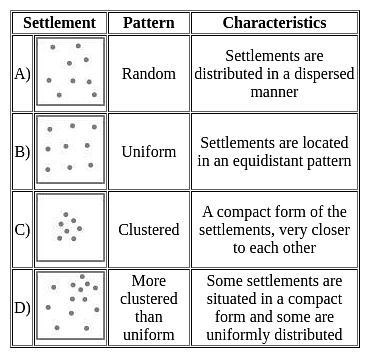
Nearest Neighbor Analysis

  • An example of the search for order in settlement or other patterns in the landscape is the use of a technique known as nearest neighbour analysis.
  • This attempts to measure the distributions according to whether they are clustered, random or regular. Nearest neighbour analysis may be used in sand dune vegetation succession studies to test the hypothesis that 'the stone pine woodland forms the climax community'.

Assertion (A) :Nearest Neighbor Analysis measures the spread or distribution of something over geographical space

  • Nearest Neighbor Analysis measures the spread or distribution of something over geographical space.
  • It provides a numerical value that describes the extent to which a set of points are clustered or uniformly spaced.
  • This command uses the Clark and Evans (1954) aggregation index R as the basis for a crude test of clustering or order of a point pattern with the help of point, line, and area.

Hence, the assertion is correct.

Reason (R) : The Rn value determines the randomness of the given settlements.

  • The Rn value determines the randomness of the given settlements.
  • For this two things are requires, Area (a) and the length between settlements.
  • The formula is,
  • Where, a = total area, n = number of settlement, D = mean distance

Hence, the reason is also correct.
Additional Information

UGC NET Paper 2 Geography Mock Test - 5 - Question 20

Identify the option that arranges the following states' literacy rates in descending order, according to Census 2011.

A. Kerala

B. Himachal Pradesh

C. Haryana

Detailed Solution for UGC NET Paper 2 Geography Mock Test - 5 - Question 20
The correct answer is (A), (B), (C).
Key Points
  • According to Census 2011, the literacy rates of the states in descending order are Kerala, Himachal Pradesh, and Haryana.
  • Kerala has the highest literacy rate of 94% among all the states in India.
  • Haryana has a literacy rate of 75.6%.
  • Himachal Pradesh has a literacy rate of 82.80%.

Additional Information

  • The Indian Census is the largest single source of a variety of statistical information on different characteristics of the people of India.
  • The first census of India was conducted by Lord Mayo in 1872.
  • The first official census was started by Lord Ripon in 1881.
  • In 2011 it is 15 census of India.
  • It comes to the Ministry of Home Affairs From 1961.
  • The slogan of the 2011 Census is Our Census Our Future.
  • C M Chandramauli was the Registrar General and Census Commissioner of India for the 2011 Indian Census.
UGC NET Paper 2 Geography Mock Test - 5 - Question 21
Which of the following is measured on Richter's scale?
Detailed Solution for UGC NET Paper 2 Geography Mock Test - 5 - Question 21

The Correct Answer is the Intensity of earthquakes

Key Points

  • The Intensity of the earthquake is measured on the Richter scale
  • Charles F. Richter developed the Richter Scale in 1935.
  • It is measured using a machine called a seismometer which produces a seismograph. A Richter scale is normally numbered 1-10, though there is no upper limit.
  • This information comes from seismographs, which collect data and directly measure the amount of ground shaking.

Additional Information

  • An earthquake is known as a quake, tremor, or temblor. It is ​a sudden release of energy in the Earth's lithosphere that creates seismic waves.
  • There are three types of earthquake waves:
    • P waves or longitudinal waves
    • S waves or transverse waves
    • L waves or surface waves
UGC NET Paper 2 Geography Mock Test - 5 - Question 22

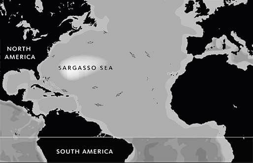
Sargasso sea is characterised by

Detailed Solution for UGC NET Paper 2 Geography Mock Test - 5 - Question 22

The correct answer is typical marine vegetation.

Key Points

  • Sargasso Sea:
    • While there are many different types of algae found floating in the ocean all around world, the Sargasso Sea is unique in that it harbors species of sargassum that are 'holopelagic' — this means that the algae not only freely floats around the ocean, but it reproduces vegetatively on the high seas.
    • The mean annual temperature is 28 degrees C.
    • Sea is covered with rootless seaweeds which obstruct navigation.
    • It is a spawning site for threatened and endangered Eels, as well as white Marlin, porbeagle Shark, and Dolphinfish.
    • Hence, Option 4 is correct.

UGC NET Paper 2 Geography Mock Test - 5 - Question 23
Which of the following question is related to the causal relationships between features?
Detailed Solution for UGC NET Paper 2 Geography Mock Test - 5 - Question 23

The correct answer is Why.

Key Points

  • A causal relationship exists when one variable in a data set has a direct influence on another variable. Thus, one event triggers the occurrence of another event.
  • A causal relationship is also referred to as cause and effect that realization to why.
  • Causal relationships in real-world settings are complex, and statistical interactions of variables are assumed to be pervasive (e.g., Brunswick 1955, Cronbach 1982). This means that the strength of a causal relationship is assumed to vary with the population, setting, or time represented within any given study, and with the researcher's choices about treatments and measurement of outcomes.
  • Without a sensitive assessment of such interactions, true effects can be obscured or causal claims can be overgeneralized to a wider range of people, settings, times, treatments, or outcome constructs than is warranted. Unfortunately, the number of possible interactions is endless, posing problems to the analyst that are insuperable, at least in theory (Cook 1993).
  • The practical task is to assess the most plausible interactions within a given research area. Interactions occur often between treatment, populations, measures, and context, posing the most plausible threats to external validity (Campbell and Stanley 1966, Cook and Campbell 1979). Because external validity specifies the conditions under which an internally valid relationship can be reproduced, threats to external validity necessarily invoke internal validity.
  • A causal generalization, e.g., that smoking causes lung cancer, is not about a particular smoker but states a special relationship exists between the property of smoking and the property of getting lung cancer.
  • To establish causality you need to show three things–that X came before Y, that the observed relationship between X and Y didn't happen by chance alone, and that there is nothing else that accounts for the X -> Y relationship.
UGC NET Paper 2 Geography Mock Test - 5 - Question 24

The histogram is the most useful to find the value of:

Detailed Solution for UGC NET Paper 2 Geography Mock Test - 5 - Question 24

The correct answer is Mode.

Key Points

  • HIstogram
    • A Histogram is an approximate representation of the distribution of numerical data.
    • It was first introduced by Karl Pearson.
    • Its purpose is to roughly assess the probability distribution of a given variable by depicting the frequencies of observations occurring in certain ranges of values.
    • Histograms are sometimes confused with bar charts.
    • It is used for continuous data, where the bins represent ranges of data while a bar chart is a plot of categorical variables.
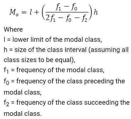
  • Mode
    • Mode is the value that appears most often in a set of data values.
    • The mode is the way of expressing in a single number, important information about a random variable or a population.
    • For a systematic histogram, the values of mode are all the same and are all located at the center of the distribution, the mode always occurs at the highest point of the peak.

Additional Information

  • Arithmetic mean
    • Arithmetic mean is the mean or the average or the sum of a collection of numbers divided by the numbers in the collection.
    • The term Arithmetic mean is preferred in some contexts in mathematics and statistics, because it helps distinguish it from other means, such as the geometric mean and the harmonic mean.
    • It is the most commonly used and readily understood measure of central tendency in a data set.

  • Median
    • The median is the middle number in a sorted ascending or descending, list of numbers and can be more descriptive of that data set than the average.
    • The median is sometimes used as opposed to the mean when there are outliers in the sequence that might skew the average of the values.
    • The median is of central importance in robust statistics, as it is the most resistant statistic.

UGC NET Paper 2 Geography Mock Test - 5 - Question 25
Which fault line is the most active fault line in Himalaya system?
Detailed Solution for UGC NET Paper 2 Geography Mock Test - 5 - Question 25

 The Main Central Thrust (MCT) lies between Greater Himalayas and Lesser Himalayas. Many earthquakes have occurred along this fault line. Some of these include earthquakes at Srinagar in 2005, Kandla in 1905, Uttarkashi in 1993 and Kathmandu in 2015. It is the most active fault line in Himalayan mountain system.

Thus, the correct answer is A.

UGC NET Paper 2 Geography Mock Test - 5 - Question 26

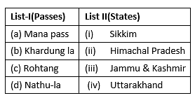
Match List-I with List-II :

Select the correct answer from the options given below:

Detailed Solution for UGC NET Paper 2 Geography Mock Test - 5 - Question 26
  • The Mana pass derives from a name of a village with the same name in Uttarakhand. It’s last village on the border of Uttarakhand. Trade here is carried out with the help of mules.
  • Khardung la is a pass in Jammu & Kashmir. At 18000 ft above the sea level, it’s the highest motor able road in the world.
  • The famous Rohtang pass in Himachal Pradesh connects the Kullu Valley with Spiti and Lahual Valley.
  • Nathu la is a pass in Sikkim that lies in East Sikkim district and serves as one of the open trading posts on the border with China.

Thus, the correct answer is B.

UGC NET Paper 2 Geography Mock Test - 5 - Question 27

Which state is the largest producer of wheat in India ?

Detailed Solution for UGC NET Paper 2 Geography Mock Test - 5 - Question 27

Uttar Pradesh is the largest Wheat producing state of India, followed by Punjab, Haryana and Madhya Pradesh.

UGC NET Paper 2 Geography Mock Test - 5 - Question 28

Area between two breaker zones is called

Detailed Solution for UGC NET Paper 2 Geography Mock Test - 5 - Question 28

The outer limit of the breaker zone (or surf zone) is called the breaker line. However, the instantaneous width of the breaker zone varies with the instantaneous wave conditions and water level.

UGC NET Paper 2 Geography Mock Test - 5 - Question 29

Deutsche mark is the currency of

Detailed Solution for UGC NET Paper 2 Geography Mock Test - 5 - Question 29

D-Mark (Deutsche Mark) was the official currency of the Federal Republic of Germany until 2002. First issued in 1948, it was the official currency of West Germany, and later, the unified German state until the final adoption of the euro (EUR) in 2002. The official currency code is DEM.

UGC NET Paper 2 Geography Mock Test - 5 - Question 30

When was the first modern paper mill of the country set up?

Detailed Solution for UGC NET Paper 2 Geography Mock Test - 5 - Question 30

Paper and Paper Board is a forest-based industry. In 1832 the first modern paper mill of the country was set up at Serampore in West Bengal.

View more questions
16 docs|120 tests
Information about UGC NET Paper 2 Geography Mock Test - 5 Page
In this test you can find the Exam questions for UGC NET Paper 2 Geography Mock Test - 5 solved & explained in the simplest way possible. Besides giving Questions and answers for UGC NET Paper 2 Geography Mock Test - 5, EduRev gives you an ample number of Online tests for practice

Top Courses for UGC NET

Download as PDF

Top Courses for UGC NET