UGC NET Exam  >  UGC NET Tests  >  UGC NET Mock Test Series 2024  >  UGC NET Paper 2 Geography Mock Test - 7 - UGC NET MCQ

UGC NET Paper 2 Geography Mock Test - 7 - UGC NET MCQ


Test Description

30 Questions MCQ Test UGC NET Mock Test Series 2024 - UGC NET Paper 2 Geography Mock Test - 7

UGC NET Paper 2 Geography Mock Test - 7 for UGC NET 2024 is part of UGC NET Mock Test Series 2024 preparation. The UGC NET Paper 2 Geography Mock Test - 7 questions and answers have been prepared according to the UGC NET exam syllabus.The UGC NET Paper 2 Geography Mock Test - 7 MCQs are made for UGC NET 2024 Exam. Find important definitions, questions, notes, meanings, examples, exercises, MCQs and online tests for UGC NET Paper 2 Geography Mock Test - 7 below.
Solutions of UGC NET Paper 2 Geography Mock Test - 7 questions in English are available as part of our UGC NET Mock Test Series 2024 for UGC NET & UGC NET Paper 2 Geography Mock Test - 7 solutions in Hindi for UGC NET Mock Test Series 2024 course. Download more important topics, notes, lectures and mock test series for UGC NET Exam by signing up for free. Attempt UGC NET Paper 2 Geography Mock Test - 7 | 100 questions in 120 minutes | Mock test for UGC NET preparation | Free important questions MCQ to study UGC NET Mock Test Series 2024 for UGC NET Exam | Download free PDF with solutions
UGC NET Paper 2 Geography Mock Test - 7 - Question 1

Match List-I and List-II and select the correct answer using the codes given below:

Detailed Solution for UGC NET Paper 2 Geography Mock Test - 7 - Question 1

The correct answer is (a) - (3), (b) - (4), (c) - (1), (d) - (2).

Key Points

  • Geosynclinal Theory -
    • The major mountain-building idea that was supported from the 19th century and into the 20th is the geosynclinal theory.
    • The fundamental concepts for geosynclinal theory were introduced in James Hall’s presidential address to the Geological Society of America at the meeting of the American Association for the Advancement of Science in Montreal in 1857.
    • His ideas were extravagant at the time; therefore, he was urged in a friendly letter by the secretary of the GSA, Joseph Henry, to introduce it slowly. Because of this, his address was not published until 1882. A principle concept of the theory is that the direction of a given mountain chain corresponds to the original line of greatest sediment accumulation.
    • James Dana helped clarify the theory in his final edition (1895) of the Manual of Geology. In this piece, he recognized Hall’s beginnings and concisely formulated the theory. 
  • Tetrahedral Hypothesis -
    • The tetrahedral hypothesis is an obsolete scientific theory attempting to explain the arrangement of the Earth's continents and oceans by referring to the geometry of a tetrahedron.
    • Although it was a historically interesting theory in the late 19th and early 20th century, it was superseded by the concepts of continental drift and modern plate tectonics.
    • The theory was first proposed by William Lowthian Green in 1875.
  • Stationary Wave Theory -
    • R.A. Harris of the U.S. Coast and Geodetic Survey propounded the concept of stationary waves as opposed to progressive waves.
    • This theory offers an almost satisfactory explanation for local differences in tides, their types, and their age.
    • According to Harris tide, phenomena are not due to progressive waves which originate in the southern oceans as claimed by William Whewell but are due to stationary waves which originate independently in each ocean.
    • In other words, tide phenomena are regional phenomena. The stationary wave theory can be explained with the help of an experiment.
    • If a rectangular tank or ‘developing tray’ containing water is rocked from one side to the other or is simply tilted, the water level rises along one side of the tray but falls along the other side.
    • This generates oscillation in the water contained in the tray. Such oscillations in the water are called stationary waves.
    • There is a center in the middle of the tray where there is no change in the level of water. This point is called the nodal point
    • . The water level moves rhythmically from one end of the tray to the other end along a line which is called the nodal line.
  • Subsidence Theory -
    • The subsidence hypothesis of coral reef development was proposed by Charles Darwin and was formulated during his voyage on the Beagle.
    • It envisaged that fringing reefs, barrier reefs, and atolls represent successive stages in an evolutionary sequence.
    • In a remarkable deduction, Charles Darwin proposed that different types of coral reefs observed in mid-ocean came about through the subsidence of underlying volcanic foundations.
    • He envisaged that fringing reefs, barrier reefs, and atolls represented different stages as a result of the vertical growth of reefs on subsiding basements. Subsequent drilling has provided support for this idea, which can be integrated into plate tectonic theory and can also accommodate many factors associated with changes in sea level.
UGC NET Paper 2 Geography Mock Test - 7 - Question 2

Which one of the following indices is used to indicate if the optimal location was closer to either raw material source or the market?

Detailed Solution for UGC NET Paper 2 Geography Mock Test - 7 - Question 2

Material Index was devised by Alfred Weber to indicate if the optimal location was closer to either raw material source or the market.

The Material Index is part of the least cost location principle and defined as the ratio of the weight of localised materials used in the industry to the weight of the product.

The material index equals 1 when there is no weight loss in the production, while if the material index is higher than 1, there is substantial weight loss.

  • Material Index = Weight of localized materials/weight of the finished products.  
  • If material index > 1 then the plant would be located near the sources of materials. 
  • If material index < 1 then the plant would be located near to the market.
1 Crore+ students have signed up on EduRev. Have you? Download the App
UGC NET Paper 2 Geography Mock Test - 7 - Question 3

Major constituent gasses of the atmosphere are _____________.

Detailed Solution for UGC NET Paper 2 Geography Mock Test - 7 - Question 3

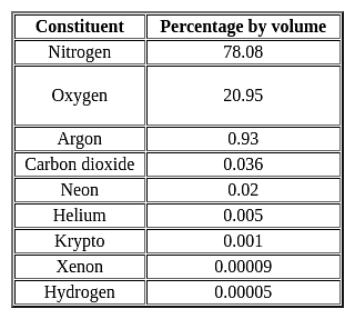
Atmosphere: The earth is surrounded by a layer of gas called the atmosphere. This thin blanket of air is an integral and important aspect of the planet.

Key-Points

Gaseous composition of the atmosphere:

  • The air in the atmosphere is a mixture of many gases like nitrogenoxygen, carbon dioxide, and water vapors.
  • The atmosphere is composed mainly of nitrogen and oxygen
  • Nitrogen and oxygen are two gases that make up the bulk of the atmosphere.
  • Carbon dioxide, helium, ozone, argon, and hydrogen are found in lesser quantities.
  • Nitrogen is the most plentiful gas in the air. It comprises 78% of the total composition of air.
  • Oxygen holding the second position by volume constitutes 21% of the atmosphere.

Hence, option 2 is the correct answer.

Important Point

UGC NET Paper 2 Geography Mock Test - 7 - Question 4

Match the list one with list two.

Choose the correct option from below :
Detailed Solution for UGC NET Paper 2 Geography Mock Test - 7 - Question 4

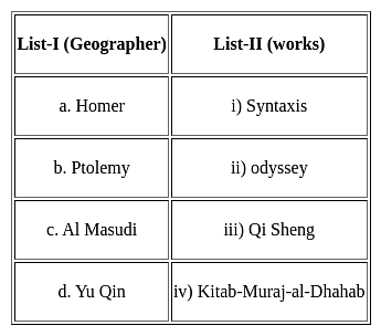
In the ancient period geography grew out of exploration, mapping of areas and materials collected. Some of the most prominent geographers of the ancient times were Arabs, Greeks, Chinese, Indians and Romans.

Odyssey is the work of Homer who is a Roman geographer.

Syntaxis is the work of Ptolemy who is a Greek geographer.

Kitab-Muraj-al-Dhahab is the work of Al Masudi who is an Arab Geographer

Qi Sheng is the work of Yu Qin who is a Chinese geographer

Thus, the Correct answer is B.

UGC NET Paper 2 Geography Mock Test - 7 - Question 5
Which of the following is a major reason for the rising development of the cotton textile industry of Mumbai?
Detailed Solution for UGC NET Paper 2 Geography Mock Test - 7 - Question 5

Among these factors, Humid climate is a major reason since this type of climate prevails in Mumbai and is essential as thread does not break frequently in such conditions. Other reasons include cheap hydroelectricity from the nearby areas and presence of black-cotton soil from the hinterland of Mumbai.

UGC NET Paper 2 Geography Mock Test - 7 - Question 6
Which one of the following is a major plate?
Detailed Solution for UGC NET Paper 2 Geography Mock Test - 7 - Question 6

The correct answer is option 4.

Key Points

Tectonic Plates:

  • A tectonic plate (also called a lithospheric plate) is a massive, irregularly-shaped slab of solid rock, generally composed of both continental and oceanic lithosphere.
  • A tectonic plate may be a continental plate or an oceanic plate, depending on which of the two occupies the larger portion of the plate.

The Major and Minor Plates: The Earth’s lithosphere is divided into seven major and some minor plates.

  • Young Fold Mountain ridges, oceanic trenches, and/or transform faults surround the major plates. These include:
    • The Antarctic (and the surrounding oceanic) plate. Hence, option 4 is correct.
    • The North American plate (with the western Atlantic floor separated from the South American plate along the Caribbean islands)
    • The South American plate (with the western Atlantic floor separated from the North American plate along the Caribbean islands)
    • The Pacific plate
    • The India-Australia-New Zealand plate
    • Africa with the eastern Atlantic floor plate
    • Eurasia and the adjacent oceanic plate
  • Some important minor plates include:
    • Cocos plate: Between Central America and the Pacific plate
    • Nazca plate: Between South America and the Pacific plate
    • Arabian plate: Mostly the Saudi Arabian landmass
    • Philippine plate: Between the Asiatic and Pacific plate
    • Caroline plate: Between the Philippine and Indian plates (North of New Guinea)
    • Fuji plate: North-east of Australia
    • Juan De Fuca plate: South-East of North American Plate. Hence, options 1, 2 and 3 are not correct.


UGC NET Paper 2 Geography Mock Test - 7 - Question 7
According to Malthus theory - 
Detailed Solution for UGC NET Paper 2 Geography Mock Test - 7 - Question 7

Concept:

Malthus Theory:

  • The theory of exponential population and arithmetic food supply growth is the Malthusian theory of population.
  • Thomas Robert Malthus proposed this theory.
  • It was believed by him that preventive and positive checks are the two factors that can establish a balance between population growth and food supply.

Major elements of Malthus' theory:

  • Checks on Population
    • When the increasing population rate is greater than the food supply, there exists a condition of disequilibrium.
    • The result of this is that people will not get enough food even for survival.
    • People will die due to a lack of food supply.
    • Adversities such as epidemics, wars, starvation, famines, and other natural calamities are named positive checks by Malthus.
    • Then there are man-made checks which are named preventive checks by Malthus.

Explanation:

Key points of Malthus' theory:

  • Thomas Malthus warned that without any checks, the population would theoretically grow at an exponential rate, rapidly exceeding its ability to produce resources to support itself.
  • Malthus argued that an exponentially growing population will self-correct through war, famine, and disease.
  • Malthus stated that to avoid a catastrophe such as famine and war, people should opt an intentional population control, such as birth control and celibacy.
  • Malthusian catastrophes refer to naturally occurring checks on population growth such as famine, disease, or war.
  • These Malthusian catastrophes have not taken place on a global scale due to progress in agricultural technology.
  • However, many argue that future pressures on food production, combined with threats such as global warming, make overpopulation a still more serious threat in the future.

Key terms:

  • Carrying capacity: The number of individuals of a particular species that an environment can support.
  • Exponential growth: The growth in the value of a quantity, in which the rate of growth is proportional to the instantaneous value of the quantity.
  • Malthusian catastrophes: Naturally occurring checks on population growth such as famine, disease, or war are termed Malthusian catastrophes.

Thus, according to Malthus's theory population grows geometrically whereas resources grow arithmetically.

UGC NET Paper 2 Geography Mock Test - 7 - Question 8

Identify the INCORRECT statement(s) (S1, S2, S3) pertaining to the Vector data Model in GIS.

S1 : Topology is static and any updation /editing of vector data requires re-building of topology.

S2: Accurate geographic location of data can be maintained.

S3 : Continuous data like elevation data can be effectively represented in vector form.

Detailed Solution for UGC NET Paper 2 Geography Mock Test - 7 - Question 8

Explanation:

GIS (Geographical Information System):

  • Geographical Information Systems (GIS) is defined as the capturing, storing, processing, and presentation of spatially referenced data.

  • This spatial data can be manipulated in different formats and patterns. One of the most important formats is the vector data model which holds topological relationships between geographic features.

  • These vector data can be derived from different methods, for example, using scanning of analog maps into raster formats and then digitizing them into vector forms.

Vector Data Model:

  • Vector data is used in GIS because of the precise nature of its representation method, storage efficiency, the quantity of its cartographic output, and the availability of functional tools for operations like map projection, overlay, and analysis.
  • In vector data models, points, lines, and polygons are used to represent spatial features or objects with clear spatial locations and boundaries.

  • Examples of vector data features are; boreholes as point features, drainage gutters as line features, and buildings as polygon features.

  • Vector data structure can be grouped into four classes namely:

  1. Simple features (non-topological).

  2. Topological features.

  3. Network data model and TIN data model.

  4. Georelational data model and Object-Based Data Model.

UGC NET Paper 2 Geography Mock Test - 7 - Question 9

Consider the following statements regarding Census-2011:

1. The percentage decadal growth of population during 2001-2011 has registered the sharpest decline since independence.

2. It created the National Population Register (NPR) which will build up a comprehensive identity database of usual residents of the country.

3. Census 2011 was conducted in two phases - the house listing phase and the population enumeration phase.

Which of the above statements is/are correct?
Detailed Solution for UGC NET Paper 2 Geography Mock Test - 7 - Question 9
  • Census 2011 was conducted in two phases:
  1. The first phase, called the House Listing or Housing Census was conducted between April and September, 2010 across the country, depending on the convenience of different States/UTs.
  2. The second phase, called the Population Enumeration, began simultaneously all over the country from February 9, 2011 and continued up to February 28, 2011.
  • The landmark of Census 2011 is the creation of the National Population Register (NPR) which will build up a comprehensive identity database of usual residents of the country. It will have the biometric data and Unique Identification (UID) number of every person (15 years and above).
  • National Identity Cards will be given in a phased manner to all usual residents by the Office of the Registrar General and Census Commissioner, India.
  • India's population as on 1 March 2011 stood at 1,210,193,422 (623.7 million males and 586.4 million females) in comparison to a total of 1, 028, 737, 436 in the year 2001. In absolute terms, the population of India has increased by more than 181 million during the decade 2001-2011.
  • The percentage decadal growth of population during 2001-2011 has registered the sharpest decline since independence. It declined from 23.87 per cent for 1981-1991 to 21. 54 per cent for the period 1991-2001, a decrease of 2.33 per cent. For 2001-2011, decadal growth has become 17.64 per cent, a further decrease of 3.90 percentage point.
UGC NET Paper 2 Geography Mock Test - 7 - Question 10

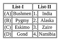
Match List - I and List - II and select the correct answer from the code given below:
Detailed Solution for UGC NET Paper 2 Geography Mock Test - 7 - Question 10

The correct answer is option 4.

Key Points

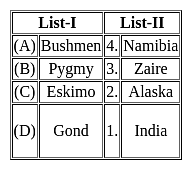
  • Bushmen are southern Africa's original inhabitants and have done so for tens of thousands of years. In Botswana, Namibia, South Africa, and Angola, there are 100,000 Bushmen.
  • An ethnic group known as the Pygmies is present in the Central African Republic, Congo, Cameroon, Gabon, Zaire, Rwanda, and Uganda.
  • Eskimo, are a group of culturally and linguistically distinctive Indigenous peoples of the Arctic and subarctic regions. Their ancestral lands include Arctic Canada, northern and southwestern Alaska in the United States, and a portion of Chukotka in Russia's Far East.
  • The Gond are a group of indigenous people who live in central and south-central India and are now formally recognised as Scheduled Tribes.
UGC NET Paper 2 Geography Mock Test - 7 - Question 11

Which of the following statements relating to Ratzel's concept of Lebensraum, is not correct?

(a) It is the geographical area within which living organisms develop.

(b) It is the economic and cultural activity of the people outside their enclosed settled area.

(c). It deals with the relation between human society and a spatial organization and its physical setting.

(d). It is a geopolitical term that studies space from the viewpoint of the state.

Choose the correct option from below:

Detailed Solution for UGC NET Paper 2 Geography Mock Test - 7 - Question 11

The correct answer is (b) and (d).
Key Points

  • The German concept of Lebensraum comprises policies and practices of settler colonialism that proliferated in Germany from the 1890s to the 1940s.
  • For Ratzel, the Lebensraum was of fundamental significance when the scientist wants to understand the spatial characteristics of life, as life cannot be separated from its spatial requirements.
  • In Ratzel’s own words: “ new form of life needs space in order to come into existence, and yet more space to establish and pass on its characteristics”
  • For Ratzel the same laws that governed organic differentiation governed the differentiation of human societies and states.
  • The focus on overpopulation and its detrimental effects were common in nineteenth-century social science.
  • The key event influencing and to some degree shaping German geographical thought during the second half of the 19th century was the publication of Charles Darwin’s On the Origin of Species by Means of Natural Selection or the Preservation of Favoured Races in the Struggle for Life.

Hence, options (a) and (c) only are correct only to Ratzel's concept of Lebensraum.

UGC NET Paper 2 Geography Mock Test - 7 - Question 12
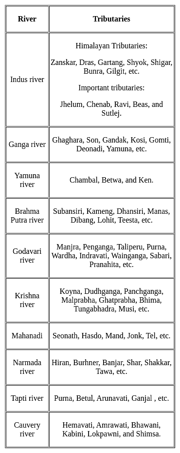
The Koyna, Tungabhadra and Bhima rivers are the major tributaries of the river ___________.
Detailed Solution for UGC NET Paper 2 Geography Mock Test - 7 - Question 12

The correct answer is Krishna.

Key Points

UGC NET Paper 2 Geography Mock Test - 7 - Question 13
According to Francois Perroux's growth pole theory, what is the primary driver of economic growth and development in a region?
Detailed Solution for UGC NET Paper 2 Geography Mock Test - 7 - Question 13

Answer: Option 3) Concentration of economic activity in specific geographic areas

The growth pole theory, developed by French economist Francois Perroux, emphasizes the role of concentrated economic activity in specific geographic areas, known as growth poles, in driving regional development.

Key Points
  • According to Perroux's theory, the primary driver of economic growth and development in a region is:
  • Concentration of economic activity in specific geographic areas: Perroux argued that economic growth is not evenly distributed across a region, but rather tends to concentrate in certain geographic areas due to the presence of agglomeration economies and other factors. These growth poles, characterized by the presence of large-scale industries, infrastructure, and skilled labor, generate positive externalities and spillover effects that spread to surrounding areas, stimulating economic growth and development.
  • Perroux's growth pole theory has been influential in regional development planning and policy. It has been used to justify government policies aimed at promoting the development of growth poles and linking them to surrounding regions.
  • Critics of the growth pole theory argue that it can lead to increased inequality between regions, as growth tends to be concentrated in a few select areas.
Additional Information
Balanced growth across all sectors: While balanced growth across all sectors is desirable, it is not always feasible or necessary for regional development. Perroux's theory recognizes that economic growth often occurs in a concentrated manner, with certain sectors and regions taking the lead.
Even distribution of income and resources: Even distribution of income and resources is a desirable goal, but it is not the primary driver of economic growth according to Perroux's theory. He argued that concentration of economic activity in growth poles can lead to increased productivity and innovation, which in turn can benefit the entire region.
Government intervention and central planning: While government intervention and central planning can play a role in regional development, Perroux's theory does not emphasize these factors as the primary drivers of growth. He believed that the private sector, driven by market forces and agglomeration economies, is the main engine of economic growth.
UGC NET Paper 2 Geography Mock Test - 7 - Question 14
According to Gunnar Myrdal's theory of circular cumulative causation, what is the main driver of economic growth?
Detailed Solution for UGC NET Paper 2 Geography Mock Test - 7 - Question 14

Answer: Option 4) Self-reinforcing processes leading to cumulative growth.

Gunnar Myrdal, a Swedish economist and social scientist, developed the theory of circular cumulative causation to explain the persistence of poverty and inequality in developing countries. This theory emphasizes the self-reinforcing nature of economic growth and decline.
Key Points
  • According to Myrdal, the main driver of economic growth is:
  • Self-reinforcing processes leading to cumulative growth: Myrdal argued that economic growth is not a smooth and evenly distributed process, but rather a cumulative one, where certain factors and processes reinforce each other, leading to increasing disparities and imbalances. He identified several mechanisms through which this cumulative process operates:
  • Spread effects: Positive developments in one sector or region can spread to other sectors and regions, leading to a virtuous cycle of growth.
  • Backwash effects: Negative developments in one sector or region can have negative impacts on other sectors and regions, leading to a vicious cycle of decline.
  • Linkages: Economic activities in different sectors and regions are interconnected, and growth in one sector can lead to increased demand for goods and services from other sectors, creating a multiplier effect.
Important Points
  • Myrdal's theory has been influential in development economics, and has been applied to various contexts, including regional development, industrialization, and poverty reduction.
  • Critics of Myrdal's theory argue that it is too deterministic and does not adequately account for the role of government intervention and policy in shaping economic outcomes.
  • Despite these criticisms, Myrdal's theory remains a valuable framework for understanding the complex dynamics of economic growth and decline.
UGC NET Paper 2 Geography Mock Test - 7 - Question 15
The innermost layer of the earth is called
Detailed Solution for UGC NET Paper 2 Geography Mock Test - 7 - Question 15

The correct answer is Core.

  • The innermost layer of the earth is called the Core.

Key Points

  • Core:
    • The core is the innermost layer of the earth and the earth's centre.
    • It is about 3500 km in radius.
    • The outer part of the core is believed to have the properties of a liquid and the innermost part of the core may be called solid or crystalline.
    • This layer is also known as Nife (nickel and iron).
    • The temperature of the core is between 2200°C and 2750°C.
    • The density of this part of the earth is 17.2 gm/cm3.

Additional Information

  • The outermost solid cover or shell of the earth is known as the earth’s crust.
    • This layer is also called Sial (silica and aluminum).
  • The mantle is the intermediate layer of the earth in terms of both its location and density.
    • The mantle layer is also known as Sima (silica and magnesium).
UGC NET Paper 2 Geography Mock Test - 7 - Question 16

From the given processes below choose the processes involved in a water cycle.

A. Condensation

B. Insolation

C. Evaporation

D. Precipitation

Detailed Solution for UGC NET Paper 2 Geography Mock Test - 7 - Question 16

Condensation, evaporation and precipitation are the processes involved in a water cycle.

Key Points

  • The process by which water continually changes its form and circulates between oceans, atmosphere and land is known as the water cycle.
  • At first, the sun’s heat causes evaporation of water into vapour. This process is called as evaporation.
  • When the water vapour cools down, it condenses and forms clouds. It is called condensation.
  • From there it may fall on the land or sea in the form of rain, snow or sleet. This is known as precipitation.
  • Given below diagram explains about the water cycle:

Hence, we can conclude that the processes involved in a water cycle are evaporation, condensation and precipitation.

UGC NET Paper 2 Geography Mock Test - 7 - Question 17
Why do coastal areas experience less contrasts in temparature conditions?
Detailed Solution for UGC NET Paper 2 Geography Mock Test - 7 - Question 17

The correct answer is due to moderating effect of the seas.

Key Points

  • Coastal areas experience fewer contrasts in temperature conditions because of the moderating effect of the seas.
  • The large water bodies help in moderating temperature.
  • Water has a higher heat capacity than soil and rock, so the ocean takes longer to heat and cool the land.
  • It means that the water takes more time to get hot or cold than land.
  • Thus on hot days, water absorbs heat keeping the air cool.
  • When the air gets cool, water slowly releases heat into the atmosphere, raising air temperatures.
  • The temperatures on land change more rapidly than temperatures on water.

Thus, we can say the coastal areas experience fewer contrasts in temperature conditions due to the moderating effect of the seas.

UGC NET Paper 2 Geography Mock Test - 7 - Question 18
The term ‘Geopolitics’ was coined by:
Detailed Solution for UGC NET Paper 2 Geography Mock Test - 7 - Question 18

The correct answer is J R Kjellen.
Key Points

  • The word geopolitics was originally coined by the Swedish political scientist Rudolf Kjellén about the turn of the 20th century, and its use spread throughout Europe in the period between World Wars I and II (1918–39) and came into worldwide use during the latter.

Geopolitics

  • Geopolitics is a concept that emerged in the early 20th century and has become increasingly relevant in today's world. It is a framework that helps us understand how countries, businesses, and other groups attempt to achieve their political goals by controlling geographic features of the world.
  • These features are referred to as geographical entities and include places, regions, territories, scales, and networks that make up the world.
  • Geopolitics focuses on the use of power and how countries and other groups compete to control these entities within the international community.
  • The control of geographical entities is seen as a means to achieve political objectives, and therefore, geopolitics is always looked at from an international and global dimension.
  • It involves the struggle for the control of geographical entities with the use of such entities for political advantage.
UGC NET Paper 2 Geography Mock Test - 7 - Question 19
Which of the research areas led to the growth of urban political geography?
Detailed Solution for UGC NET Paper 2 Geography Mock Test - 7 - Question 19

The two main research areas, urban conflicts and the development of the concepts of electoral geography such as the geography of voting, geographical influences in voting, the geography of representation led to the development of urban political geography. Radical geography was created as after the political events of the Cold war, the geography became more politicized and this also led to Marxist geography.

UGC NET Paper 2 Geography Mock Test - 7 - Question 20
Given below are two statements- one is labelled as Assertion (A) and the other is labelled as Reason (R):

Assertion(A)- Wegener was of the view that western and eastern coastlines of the Atlantic Ocean are in Jig-saw fit.

Reason(R)- The Continental drift theory was based primarily on two premises, which were polar wandering and matching of geological formations.

Choose the correct option:

Detailed Solution for UGC NET Paper 2 Geography Mock Test - 7 - Question 20

Alfred Wegener based his theory of the basis of the following premises. Firstly, the geological formations and fossil remains of the present far away continents showed similarities. Secondly, some of the continents showed complementary coastlines, such as the East coast of South America matches the West coast of Africa. Polar Wandering or Paleomagnetism and geological matching are some of the evidences which were cited by Wegener to show that the continents were close once.

UGC NET Paper 2 Geography Mock Test - 7 - Question 21
Most tsunamis occur in
Detailed Solution for UGC NET Paper 2 Geography Mock Test - 7 - Question 21

The Pacific Ocean is a geologically active area. There are many active fault lines in the area of ring of fire and several active volcanoes. Thus, the Pacific Ocean has the most number of tsunamis, nearly 80 %.

Thus, the correct answer is C.

UGC NET Paper 2 Geography Mock Test - 7 - Question 22
Given below are two statements- one is labelled as Assertion (A) and the other is labelled as Reason (R):

Assertion(A)- The Sugar industry in southern regions of India is more productive.

Reason(R)- Sugar industry is gradual shifting from North India to the peninsular India.

Choose the correct option:

Detailed Solution for UGC NET Paper 2 Geography Mock Test - 7 - Question 22

There are a certain number of reasons behind this shifting which are:- Peninsular Indian comprises of a tropical climate which provides higher yield per unit area. Secondly, the sucrose content is high; Thirdly, large sugar lobby and better managed cooperative sugar mills in the south are also a reason.

UGC NET Paper 2 Geography Mock Test - 7 - Question 23
The process in which the outer layers of rocks are peeled off from the main mass of the rock in the form of concentric shells is known as:
Detailed Solution for UGC NET Paper 2 Geography Mock Test - 7 - Question 23

Exfoliation is one of the processes of Mechanical weathering where the expansion and contraction phases occur more on the outer rock layers than in the inner layers due to which the layers of concentric shells get peeled off from the main rock mass.

UGC NET Paper 2 Geography Mock Test - 7 - Question 24
Given below are two statements. One is labelled as Assertion (A) and the other is labelled as Reason (R).

Assertion (A): The Puranas name the region of Madagascar and Eastern Africa as Shalmali.

Reason (R) : The region of East-Africa is rich in silk-cotton trees.

Select the correct answer from options given below:

Detailed Solution for UGC NET Paper 2 Geography Mock Test - 7 - Question 24

As per the Puranas, the East African and Madagascar region was called as Shalmali. The silk-cotton was called salmala and it was found in the said region. The area had moderate rainfall and was located on margin of equatorial region, which led to blossom of silk-cotton trees. Thus, both (A) and (R) are true and (R) is the correct explanation of (A).

Thus, the correct answer is A.

UGC NET Paper 2 Geography Mock Test - 7 - Question 25
The swamp forests of India are found in delta of
Detailed Solution for UGC NET Paper 2 Geography Mock Test - 7 - Question 25

The swamp forests are found in and around deltas, estuaries and creeks. In India, they are confined to deltas of Ganga, Mahanadi, Godavari, Krishna and Cauvery. The can survive in fresh as well as brackish waters. The most prominent example is Sunderban forest in the delta of Ganga River.

UGC NET Paper 2 Geography Mock Test - 7 - Question 26

At which among the following places, Brahamputra takes a U-turn at the time of entering into India?

Detailed Solution for UGC NET Paper 2 Geography Mock Test - 7 - Question 26

Namcha Barwa is a mountain in the Tibetan Himalaya. The traditional definition of the Himalaya extending from the Indus River to the Brahmaputra would make it the eastern anchor of the entire mountain chain, and it is the highest peak of its own section as well as Earth's easternmost peak over 7,600 metres (24,900 ft)

UGC NET Paper 2 Geography Mock Test - 7 - Question 27

Which of the following tribes is not found in Central India ?

Detailed Solution for UGC NET Paper 2 Geography Mock Test - 7 - Question 27

Todas tribes is not found in Central India. Toda Tribe is the most ancient and unusual tribe of Nilgiri Hills of Tamil nadu. The todas have their own language.

UGC NET Paper 2 Geography Mock Test - 7 - Question 28

The famous “Chatham Saw Mill” is located in which among the following states / union territories of India?

Detailed Solution for UGC NET Paper 2 Geography Mock Test - 7 - Question 28

Chatham Saw Mill is the saw mill situated in Chatham Island of Andaman and Nicobar Islands in India. It was set up in 1883 with the primary objective to meet the local requirements of saw and timber for the constructional works.

UGC NET Paper 2 Geography Mock Test - 7 - Question 29

The average air pressure at the sea level is ……………… millibars

Detailed Solution for UGC NET Paper 2 Geography Mock Test - 7 - Question 29

Standard sea-level pressure, by definition, equals 760 mm (29.92 inches) of mercury, 14.70 pounds per square inch, 1,013.25 × 103 dynes per square centimetre, 1,013.25 millibars, one standard atmosphere, or 101.325 kilopascals.

UGC NET Paper 2 Geography Mock Test - 7 - Question 30

The difference between maximum and minimum temperature of the day is called …………..

Detailed Solution for UGC NET Paper 2 Geography Mock Test - 7 - Question 30

The temperature of air measured using a maximum-minimum thermometer can be used to show the difference in temperature over a period of time, usually one day. The difference between the daily maximum and the daily minimum is called the diurnal range.

View more questions
16 docs|120 tests
Information about UGC NET Paper 2 Geography Mock Test - 7 Page
In this test you can find the Exam questions for UGC NET Paper 2 Geography Mock Test - 7 solved & explained in the simplest way possible. Besides giving Questions and answers for UGC NET Paper 2 Geography Mock Test - 7, EduRev gives you an ample number of Online tests for practice

Top Courses for UGC NET

Download as PDF

Top Courses for UGC NET