UGC NET Exam  >  UGC NET Tests  >  UGC NET Mock Test Series 2024  >  UGC NET Paper 2 Geography Mock Test - 9 - UGC NET MCQ

UGC NET Paper 2 Geography Mock Test - 9 - UGC NET MCQ


Test Description

30 Questions MCQ Test UGC NET Mock Test Series 2024 - UGC NET Paper 2 Geography Mock Test - 9

UGC NET Paper 2 Geography Mock Test - 9 for UGC NET 2024 is part of UGC NET Mock Test Series 2024 preparation. The UGC NET Paper 2 Geography Mock Test - 9 questions and answers have been prepared according to the UGC NET exam syllabus.The UGC NET Paper 2 Geography Mock Test - 9 MCQs are made for UGC NET 2024 Exam. Find important definitions, questions, notes, meanings, examples, exercises, MCQs and online tests for UGC NET Paper 2 Geography Mock Test - 9 below.
Solutions of UGC NET Paper 2 Geography Mock Test - 9 questions in English are available as part of our UGC NET Mock Test Series 2024 for UGC NET & UGC NET Paper 2 Geography Mock Test - 9 solutions in Hindi for UGC NET Mock Test Series 2024 course. Download more important topics, notes, lectures and mock test series for UGC NET Exam by signing up for free. Attempt UGC NET Paper 2 Geography Mock Test - 9 | 100 questions in 120 minutes | Mock test for UGC NET preparation | Free important questions MCQ to study UGC NET Mock Test Series 2024 for UGC NET Exam | Download free PDF with solutions
UGC NET Paper 2 Geography Mock Test - 9 - Question 1

Which is of the following is negative consequence of migration?

I. It put pressure on social and physical infrastructure in the urban areas

II. It creates anonymity, which creates social vacuum and sense of dejection among individuals

III. Remittances from the international migrants are one of the major sources of foreign exchange

Detailed Solution for UGC NET Paper 2 Geography Mock Test - 9 - Question 1

Option 2 is correct, i.e I and II.

  • Migration creates both benefits and problems for the areas, people migrate from and migrate to.
  • Consequences can be observed in economic, social, cultural, political and demographic terms
  • A major benefit for the source region is the remittance sent by migrants.
  • Remittances from international migrants are one of the major sources of foreign exchange.
  •  It has serious negative consequences such as anonymity, which creates a social vacuum and a sense of dejection among individuals.
  • A continued feeling of dejection may motivate people to fall into the trap of anti-social activities like crime and drug abuse.
  • Overcrowding of people due to rural-urban migration has put pressure on the existing social and physical infrastructure in the urban
    areas.
  • This ultimately leads to unplanned growth of urban settlement and the formation of slums shanty colonies.
UGC NET Paper 2 Geography Mock Test - 9 - Question 2

Which type of sensors used the man-made source of energy for data collection?

Detailed Solution for UGC NET Paper 2 Geography Mock Test - 9 - Question 2

Explanation:

There are two types of sensors in remote sensing:

1) Passive remote sensing (Sensor):

  • It depends on a natural source to provide energy for data collection. Sun is the most commonly used source of energy for passive remote sensing.
  • However, passive remote sensing can be done in absence of the Sun. In this case, the target material itself is the source of energy, and the sensor records primarily emitted radiation.
  • Examples: Return bram vidicon, Electro-optical scanner, and Electro-optical radiometer use light as the primary source.

2) Active remote sensing (Sensor):

  • It uses a man-made source of energy. In this case, humans can manipulate the nature of source energy (wavelength, power, duration).
  • Examples: Radar
1 Crore+ students have signed up on EduRev. Have you? Download the App
UGC NET Paper 2 Geography Mock Test - 9 - Question 3

Consider the following statements:

1. Indian Mahogany species is well-known for its dense, redwood.

2. Mahogany can be found in almost every part of India.

3. Indian scientists discovered that the mahogany tree emits a sulphur compound that can help to reduce atmospheric warming caused by greenhouse gases.

4. Mahogany is considered a Mesophyte.

5. It is a fast-growing upright tree with an outwardly rounded symmetrical crown.

How many of the above statements are correct? 

Detailed Solution for UGC NET Paper 2 Geography Mock Test - 9 - Question 3

The correct answer is All five.

Key Points

Indian mahogany trees

  • It can grow to be 30-40 feet tall.
  • It is a fast-growing upright tree with an outwardly rounded symmetrical crown. Hence, Statement 5 is correct.
  • It has a spread of 20-30 feet.
  • The fruit is a large greenish-brown capsule that splits into five sections, each containing flat, long-winged, light brown seeds.
  • It is made of red-brown Indian-mahogany-trees wood. On the same plant, both male and female flowers are produced.
  • Mahogany is considered a Mesophyte. Hence, Statement 4 is correct.
  • The bark is smooth and dark brown. The leaves are pinnate and range in length from 12 to 25 cm, with four to eight leaflets.
  • The species is well-known for its dense, redwood. Hence, Statement 1 is correct.
  • Initially, the Spanish and English used mahogany to build ships. Then it was used in furniture.
  • The Spanish were the first to do this, but English workshops used it extensively in the 18th and early 19th centuries. This epoch is known as the "Age of Mahogany."
  • Other names for Indian Mahogany include Mahogany, West Indian Mahogany, Spanish mahogany, Madeira redwood, acajou, caoba, caoba de Santo, cheria mahogany, Cuban mahogany, American mahogany, True mahogany, small leaf mahogany, and Dominican mahogany.
  • Mahogany can be found in almost every part of India. It is also found in India's Thattekkad Wildlife Sanctuary, Kaziranga National Park, and Corbett National Park. Hence, Statement 2 is correct.
  • Indian scientists discovered that the mahogany tree emits a sulphur compound that can help to reduce atmospheric warming caused by greenhouse gases. Hence, Statement 3 is correct.
UGC NET Paper 2 Geography Mock Test - 9 - Question 4

Himalayan Yew is an important plant for medicinal plants found in various parts of Himachal Pradesh and Arunachal Pradesh. It has been characterized as endangered by IUCN due to

1. Depletion of an inter-species gene bank of Yew.

2. Threat of bio-piracy.

3. Soaking of groundwater in areas where it is present.

Detailed Solution for UGC NET Paper 2 Geography Mock Test - 9 - Question 4

The correct answer is None of the above.

Important Points

  • Yew has undergone a recent, range-wide population decline of at least 50% as per IUCN. 
  • Throughout its range in the western Himalayas, it is declining in response to a range of threats.
  • In Afghanistan, up to 50% of the forests where it occurs have been destroyed or heavily logged (UNEP 2003) over the last 30 years.
  • In northwest India and western Nepal, exploitation associated with Taxol production has led to a national decline of up to 90% in Taxus populations throughout the country.
  • Also, in other countries such as Pakistan, overexploitation for fuel, fodder, and medicinal use has led to a significant decline.
  • The decline is continuing and while the causes are largely understood, in many areas they will not be reversible. On this basis, an assessment of Endangered is warranted. So, options 1, 2 and 3 are NOT correct.
UGC NET Paper 2 Geography Mock Test - 9 - Question 5
Natural change and ______ are the two factors that affect population change for a particular area.
Detailed Solution for UGC NET Paper 2 Geography Mock Test - 9 - Question 5

Three primary factors account for population change, or how much a population is increasing or decreasing. These factors are birth rate, death rate, and migration.

  • Births and deaths are natural causes of population change. The difference between the birth rate and the death rate of a country or place is called the natural increase. The natural increase is calculated by subtracting the death rate from the birth rate.

Key Points

  • Human migration involves the movement of people from one place to another with intention of settling, permanently or temporarily, at a new location.

Additional Information

  • Zero population growth refers to a population that is unchanging – it is neither growing nor declining; the growth rate is zero.
  • Immigration is the international movement of people to a destination country of which they are not natives or where they do not possess citizenship in order to settle as permanent residents or naturalized citizens.

Natural change and Migration are the two factors that affect population change for a particular area. Therefore Option 4 is the correct answer.

UGC NET Paper 2 Geography Mock Test - 9 - Question 6
Which one of the following statements correctly depicts the threshold according to Central Place Model ?
Detailed Solution for UGC NET Paper 2 Geography Mock Test - 9 - Question 6

Important PointsCentral place theory:

  • Central Place Theory is a spatial theory in urban geography and urban economics.
  • CPT explains the spatial arrangements, patterns, and distribution of urban areas and human settlements. 
  • Central place theory was given by Walter Christaller in 1933 on the basis of settlement patterns in southern Germany.
  • This study included analyzing the relationships between settlements of different sizes and related their economic activities (market) with the population. 
  • It is based upon the central place system and city size distribution.
  • Various geographers and urban planners study such theories and urban development models as a part of urban studies, regional science and hierarchical arrangement of human settlements.
Key Points

The theory then relied on two concepts: threshold and range.

  • The threshold is the minimum market size (population) needed to support a central place function (service).
  • The range is the maximum distance people are willing to travel to obtain a central place function (service).

There are three fundamental concepts

  • Concept of centrality: it means the importance of the central or focal point which offers goods and services to the complementary area
  • Complementary area: the area served by the central place
  • Concept of hierarchy: the arrangement of the settlement based on their number and size. Generally, there are seven or more levels in a meso-region. In India, there are six levels of settlements.

Hence, the threshold is the minimum number of people needed to support a service.

UGC NET Paper 2 Geography Mock Test - 9 - Question 7
Who among the following is considered as the father of Plate Tectonics?
Detailed Solution for UGC NET Paper 2 Geography Mock Test - 9 - Question 7

The correct answer is Alfred Wegener.

Key Points

  •  Continental Drift Theory (Alfred Wegener).
    • Continental drift theory was proposed by Alfred Wegener in 1912
    • It was first put forward by Abraham Ortelius in 1596 before fully being developed by Albert Wegener.
    • The theory deals with the distribution of the oceans and the continents.
    • According to Wegener’s Continental Drift theory, all the continents were one single continental mass (called a Supercontinent) – Pangaea and a Mega Ocean surrounded this supercontinent. The Mega Ocean is known by the name Panthalassa.
    • Although Wegener's initial theory did not cover mantle convection until Arthur Holmes later proposed the theory.
    • According to this theory, the supercontinent, Pangaea, began to split some two hundred million years back.
    • Pangaea first split into 2 big continental masses known as Gondwanaland and Laurasia forming the southern and northern modules respectively.
    • Later, Gondwanaland and Laurasia continued to break into several smaller continents that exist today.

Additional Information

UGC NET Paper 2 Geography Mock Test - 9 - Question 8

Given below are two statements. One is labelled as Assertion (A) and the other is labelled as Reason (R).

Assertion(A) : Unsupervised Classification normally requires only a minimal amount of input from the analyst.

Reason(R) : A priori knowledge of the scene or training sites are required to run this classification.
Select the correct answer from options given below :

Detailed Solution for UGC NET Paper 2 Geography Mock Test - 9 - Question 8

Unsupervised classification is a process whereby numerical operations are performed by the computer system itself that search for the natural groupings of the spectral properties of pixels in the multi spectral feature space. This method doesn't require much initial output and a priori knowledge of the scene as clustering does not involve training data.

Thus, the Correct answer is C.

UGC NET Paper 2 Geography Mock Test - 9 - Question 9
Match List-I with List-II

Code:

Detailed Solution for UGC NET Paper 2 Geography Mock Test - 9 - Question 9

  • 21st March is the day of equinox. The sun is directly above the equator. The equinox also occurs on 23rd September. The day and night last12 hours each on these days.
  • 1st June is the day that is expected arrival of monsoon in India. Though this just expected date, usually monsoon arrives later.
  • 22nd Dec is winter solstice. This is supposed to be the longest night. On this day, the sun is overhead at the tropic of Capricorn.
  • 21st June the day of longest summer solstice. The sun is overhead the tropic of cancer on the day of summer solstice.

Thus, the correct answer is A.

UGC NET Paper 2 Geography Mock Test - 9 - Question 10
The ratio of agricultural inputs to agricultural outputs is the measurement for _________.
Detailed Solution for UGC NET Paper 2 Geography Mock Test - 9 - Question 10

The concept of agricultural productivity is not synonymous to fertility. Agricultural productivity can be measured by calculating the ratio of agricultural inputs such as land, labour, capital, etc. to the agricultural output such as produce yielded, measured in calories or monetary value. As per the 23rd Annual Conference of the Indian Society of Agricultural Economics, yield per hectare in a region is considers as a representation of agricultural productivity.

Thus, the correct answer is B.

UGC NET Paper 2 Geography Mock Test - 9 - Question 11
Consider the following statements:-

a) L.C . King’s theory is based on the arid topography as well as the semi-arid regions of South Africa.

b) He mentioned that the profile of an ideal hillslope must consist of summit, scarp, slope and pediments.

c) According to King, the African landscape consisted of scarps which have steep slopes and varied in angle from 15-30 degree.

d) He also did explain the presence of Yardangs and Zuegen as prime features of the African Landscape.

Which of the following options are correct?

Detailed Solution for UGC NET Paper 2 Geography Mock Test - 9 - Question 11

L.C. King never gave any explanation regarding the presence of Yardangs or Zuegen. King said that the African Landscape consists of three basic elements, such as Rock pediments with a concave slope, scarps with a steep slope and inselbergs which are steep residual hills that vary in size and shape.

UGC NET Paper 2 Geography Mock Test - 9 - Question 12
Which period in demographic history of India is known as the 'demographic divide'?
Detailed Solution for UGC NET Paper 2 Geography Mock Test - 9 - Question 12

The period of stagnant population or the year of 1921 is referred to as the demographic divide. During most of the 19th century India witnessed a slow growth of population which continued till the year 1921. The population was more or less stagnant, and the high birth rate was counterbalanced by high death rate. Large scale abnormal deaths were present in this period. The census year of 1921 witnessed only a negative growth rate of -0.31% which was observed only once in India.

UGC NET Paper 2 Geography Mock Test - 9 - Question 13
The classical theory of Indian Monsoon was explained by
Detailed Solution for UGC NET Paper 2 Geography Mock Test - 9 - Question 13

 Although there are mentions of Indian Monsoon in the Rig Veda and Al Masudi’s works, the concept of Indian Monsoon was explained in 1686 by Sir Edmund Halley. Halley said that monsoon resulted due to thermal contrast between continents and oceans because of differential heating.

Thus, the correct answer is B.

UGC NET Paper 2 Geography Mock Test - 9 - Question 14
Geographical transfer of culture traits by movements of people across space is which kind of diffusion-
Detailed Solution for UGC NET Paper 2 Geography Mock Test - 9 - Question 14

The correct answer is Relocative
Key Points

Relocative:

  • It is the geographical transfer of culture traits by movements of people across space.
  • As the location continuously changes, this type of diffusion is coined relocation diffusion.
  • An example is the movement of a bush fire, which has burned out at the origin but continues to spread at the periphery.
  • Immigration from country to country, city to city, etc.
  • As they relocate to a new location, they bring their ideas, cultural tradition such as food, music, and more.

Additional InformationCulture diffusion

  • Culture diffusion, also often called cultural diffusion or transcultural diffusion, is a term from anthropology, specifically cultural anthropology, a subfield that focuses on how cultures vary among the human population. Cultural diffusion describes the spread of one culture’s practices, beliefs, and/or items, like food, music, or tools.
  • Hierarchical Diffusion
  1. It is when an idea spreads by passing first among the most connected individuals, then spreading to other individuals.
  2. Think of the chain of command in businesses, and the government.
  3. There’s somewhat of a hierarchy in terms of position of authority.

Expansion Diffusion

  1. Expansion diffusion is the spread of a factor or an innovation from a centre with the concentration of things being diffused throughout the society.

Contagious Diffusion

  1. It is the expansion which affects all the individuals and areas uniformly from a source region.
  2. The introduction of a new fashion trend which spreads like a wildfire through various social media sites can be cited as an example.
UGC NET Paper 2 Geography Mock Test - 9 - Question 15
In GIS, interpolation is made possible by a principle called
Detailed Solution for UGC NET Paper 2 Geography Mock Test - 9 - Question 15

Explanation:

Spatial Autocorrelation:

  • Interpolation is made possible by a principle called spatial autocorrelation.
  • The term spatial autocorrelation refers to the presence of systematic spatial variation in a mapped variable. Where adjacent observations have similar data values the map shows positive spatial autocorrelation. Where adjacent observations tend to have very contrasting values then the map shows negative spatial autocorrelation.

Spatial autocorrelation may arise from any one of the following situations:

  • the difference between the (large) scale of variation of a phenomenon and the (small) scale of the spatial framework used to capture or represent that variation
  • measurement error
  • spatial diffusion, spillover, interaction, and dispersal processes
  • inheritance by one variable through causal association with another; and
  • model misspecification

Thematic Correlation:

  • Thematic correlation involves an analysis of relevant themes and motifs within a passage and that passage's contribution to the broader biblical message pertaining to those motifs.
UGC NET Paper 2 Geography Mock Test - 9 - Question 16
Which one of the following in the leading producer of coffee?
Detailed Solution for UGC NET Paper 2 Geography Mock Test - 9 - Question 16

The correct answer is Karnataka.

Key Points

  • The state of Karnataka is the leading producer of coffee in India.
  • Karnataka is the country's largest coffee-producing state, accounting for nearly 71 per cent.
  • The Karnataka districts of Chikmagalur, Kodagu, and Hassan are major coffee-producing regions of the state. 
  • In the latest financial year, Karnataka produced 2.33 Lakh Metric Tonnes of coffee.
  • In Karnataka, coffee is cultivated in a wide area and accounts for over 60 % of the total area under coffee cultivation in India.
  • The key factors for the production of coffee in large quantities in Karnataka is the required temperature, climate, and rainfall.

Additional Information

  • Kerala:​
    • Arabica and Robusta coffee beans are grown in the Malabar region of Kerala.
    • Kerala, across the hills of the Wayanad district near Kalpetta, accounts for 21% of India's coffee production. 
  • Tamil Nadu:
    • The state of Tamil Nadu accounts for 5% of India's total coffee production in the Nilgiris District, Yercaud, and Kodaikanal.
    • In the Eastern Ghats, the Shevaroy Hills have many old coffee plantations in Tamil Nadu.
  • Maharashtra:
    • Maharashtra's Chikhaldara Hill Station is the only coffee-growing area in Maharashtra and a must-see destination to visit from October to June.
UGC NET Paper 2 Geography Mock Test - 9 - Question 17

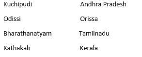
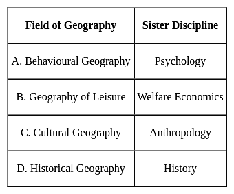
Which of the following is not correctly matched?
Detailed Solution for UGC NET Paper 2 Geography Mock Test - 9 - Question 17
UGC NET Paper 2 Geography Mock Test - 9 - Question 18

For finding Mode from formula class interval should be

Detailed Solution for UGC NET Paper 2 Geography Mock Test - 9 - Question 18

For finding Mode from the formula class interval should be overlapping.

UGC NET Paper 2 Geography Mock Test - 9 - Question 19

According to Malthus, what are preventive checks in the context of population control?

Detailed Solution for UGC NET Paper 2 Geography Mock Test - 9 - Question 19

Option 2) Measures taken by individuals to control their own reproduction.

Thomas Malthus was an English economist and demographer who developed the Malthusian Theory of Population in the late 18th century. Malthus believed that population growth was exponential, while the growth of resources was arithmetic. This meant that population growth would eventually outstrip the growth of resources, leading to famine, disease, and other social problems.

Key Points

Measures taken by individuals to control their own reproduction.

  • This is a correct definition of preventive checks.
  • Preventive checks are measures that individuals take to control their own reproduction, such as birth control, late marriage, and abstinence.
  • Malthus also believed that there were two types of checks on population growth: preventive checks and positive checks.
  • Preventive checks are measures that individuals take to control their own reproduction, while positive checks are factors that limit population growth, such as famine, disease, and war.

Additional Information

  • Natural phenomena limiting population growth.

This is not a correct definition of preventive checks. Natural phenomena are positive checks on population growth, not preventive checks.

  • Technological advancements in agriculture.

This is not a correct definition of preventive checks. Technological advancements in agriculture can increase the growth of resources, but they do not prevent population growth.

  • Positive checks on population growth.

This is not a correct definition of preventive checks. Positive checks are factors that limit population growth, such as famine, disease, and war. Preventive checks are measures that individuals take to control their own reproduction.

Important Points

  • Malthus believed that preventive checks were more effective than positive checks in controlling population growth.
  • He argued that positive checks were often brutal and inhumane, while preventive checks were voluntary and more likely to be accepted by individuals.
UGC NET Paper 2 Geography Mock Test - 9 - Question 20

What is the primary assertion of the Malthusian Theory of Population?

Detailed Solution for UGC NET Paper 2 Geography Mock Test - 9 - Question 20

Resources grow exponentially, while population grows at an arithmetic rate.

The Malthusian Theory of Population is a theory of population growth that was developed by Thomas Malthus in the late 18th century. The theory states that population growth is exponential, while the growth of resources is arithmetic. This means that population growth will eventually outstrip the growth of resources, leading to famine, disease, and other social problems.

Key Points

Resources grow exponentially, while population grows at an arithmetic rate.

  • This is the primary assertion of the Malthusian Theory of Population.
  • Malthus believed that population growth was exponential, meaning that it would increase by a fixed percentage each year.
  • He also believed that the growth of resources was arithmetic, meaning that it would increase by a fixed amount each year.
  • This meant that population growth would eventually outstrip the growth of resources, leading to famine, disease, and other social problems.
  • The Malthusian Theory of Population has been criticized by many economists and demographers.
  • However, it remains an important theory in the study of population growth

Additional Information

  • Resources and population grow at the same rate.

This is not a correct statement of the Malthusian Theory of Population. Malthus believed that population growth was exponential, while the growth of resources was arithmetic. This meant that population growth would eventually outstrip the growth of resources.

  • Population growth is exponential, and resources grow at a faster rate.

This is not a correct statement of the Malthusian Theory of Population. Malthus believed that population growth was exponential, while the growth of resources was arithmetic. This meant that population growth would eventually outstrip the growth of resources.

  • Both population and resources grow at an unpredictable rate.

This is not a correct statement of the Malthusian Theory of Population. Malthus believed that population growth was exponential, while the growth of resources was arithmetic. This meant that population growth would eventually outstrip the growth of resources.

UGC NET Paper 2 Geography Mock Test - 9 - Question 21

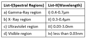
Match the List-I with List-II two.

Choose the correct answer form the code given below:

Detailed Solution for UGC NET Paper 2 Geography Mock Test - 9 - Question 21

In remote sensing technique, the electromagnetic radiation emitted or reflected from the objects must pass through atmosphere before it is detected by the remote sensor. Remote sensing by satellite involve atmospheric degradation. Hence the atmospheric conditions determine the effective use of electromagnetic spectrum for remote sensing.

  • Wavelength of visible region is 0.4-0.7µm.
  • Wavelength of ultraviolet region is 0.3 to 4µm.
  • Wavelength of X ray region is 0.03to 3.0 nm.
  • Wavelength of gamma ray region is less than 0.03nm.

Thus, the Correct answer is A.

UGC NET Paper 2 Geography Mock Test - 9 - Question 22
Given below are two statements. One is labelled as Assertion (A) and the other is labelled as Reason (R).

Assertion (A): The temperature increases in the stratosphere.

Reason (R) : The boundary between stratosphere and mesosphere is called as stratopause.

Select the correct answer from options given below:

Detailed Solution for UGC NET Paper 2 Geography Mock Test - 9 - Question 22

The stratosphere has the additional ozone layer. This layer absorbs the harmful ultraviolet rays of the sun. That leads to increase in the temperature of the stratosphere. The boundary between mesosphere and stratosphere is called stratopause, which is located at about 50 km from the earth’s crust. Thus, both (A) and (R) are true, but (R) is not the correct explanation of (A).

Thus, the correct answer is B.

UGC NET Paper 2 Geography Mock Test - 9 - Question 23
Which of the following statements are true?

(a) The western coast of Mahrashtra is the region most prone to cyclonic storms.

(b) The river Chambal in the North Indian plain is susceptible to frequent flooding.

(c) The north-eastern states lie in the earthquake prone region.

(d) The eastern coast of India has most vulnerability to cyclones.

Detailed Solution for UGC NET Paper 2 Geography Mock Test - 9 - Question 23

 The eastern coast of India has always been prone to cyclonic storms. The major ones include like Fani and Gaja most recently. Western coast of Mahrashtra on the other hand does not have much vulnerability to cyclones. The coastline of Gujarat is more vulnerable to cyclones. The north-eastern states lie in the Arkan Yoma mountain range and has had earthquakes like Tura(8.7-1897) and Cachar(7.5-1869) and more recently, on India-Nepal Border near Sikkim(7.1-2011). The river Chambal in North-Indian plains is not susceptible to floods on a frequent basis.

Thus, the correct answer is D.

UGC NET Paper 2 Geography Mock Test - 9 - Question 24

Two statements are given below. One is Assertion (A) and other is Reason (R):

Assertion(A)-El-Nino causes change in atmospheric circulation and water temperature.

Reasoning(R)-There is an increased Rainfall in eastern pacific.

Choose the correct answer:

Detailed Solution for UGC NET Paper 2 Geography Mock Test - 9 - Question 24

The change in the atmospheric circulation and water temperature results in increased rainfall in the eastern pacific and decreased rainfall in the western pacific. This effects the monsoon current over the Indian sub-continent resulting in low rainfall during the monsoon season.

UGC NET Paper 2 Geography Mock Test - 9 - Question 25
Match List-I with List-II:

Choose the correct option from the code given below:

Detailed Solution for UGC NET Paper 2 Geography Mock Test - 9 - Question 25

C.G. Bates in 1935 proposed that drought happens when the annual precipitation is 75% or less than normal precipitation and monthly precipitation is 60% or less than of normal monthly precipitation.

J.C. Hoyt in 1936 explained that drought occurs when annual and monthly rainfall is less than 85% of normal rainfall.

According to V.A. Conard in 1944, period of 20 or more consecutive days without 0.25 inch precipitation in 24 hours during the months of march -September.

D.A. Ramdas in 1950 claimed that drought occurs when the rainfall for a week is half normal or less.

UGC NET Paper 2 Geography Mock Test - 9 - Question 26
Given below are the two statements, one labelled as Assertion (A) and the other labelled as Reason (R). Select your answer from the code given below:

Assertion (A): The gradual increase in depth of river valleys has occurred in the youthful stage of rivers.

Reason (R): The channel gradient is steep in the youthful stage of the river.

Detailed Solution for UGC NET Paper 2 Geography Mock Test - 9 - Question 26

As per W. M. Davis, the cycle of erosion is divided into three stages, namely, youthful stage, mature stage and old stage. In the youthful stage, the channel gradient and slope are very steep in the youthful stage. This leads to an increase in kinetic energy and velocity of the river. This causes the transportation capacity of the river to increase. The river can carry the big boulders due to their high speed. These big boulders cause the vertical erosion of valleys. Thus, a gradual increase in depth of valleys is caused in the youthful stage of the river.

UGC NET Paper 2 Geography Mock Test - 9 - Question 27

Match List-I with List-II

Select the correct answer from the options given below:

Detailed Solution for UGC NET Paper 2 Geography Mock Test - 9 - Question 27
  • The largest producer of Barley in the country is Rajasthan. It produces nearly 40% of the total production. Tonk, Sawai Madhopur, Bharatpur are major Barley producing region of the Rajasthan.
  • West Bengal is the largest producer of jute. It produces three-fourths of the total jute of the country and has two-third of the total area under jute production.
  • Uttar Pradesh is the largest producer of sugar cane In India. It accounts for 36% of the total production and has nearly 43% of the total area in sugar cane production.
  • Andhra Pradesh leads in the production of groundnut. It produces nearly 23%of the total production of India. Chitoor, Kunoor and Anantapur districts are the districts which have groundnut.
UGC NET Paper 2 Geography Mock Test - 9 - Question 28

Which of the following statements is NOT true?

Detailed Solution for UGC NET Paper 2 Geography Mock Test - 9 - Question 28

Photochemical smog always contains Ozone, The toxic effect of Carbon Monoxide is due to its greater affinity for haemoglobin as compared to oxygen, Lead is the most hazardous metal pollutant of automobile exhaust. all are true.

UGC NET Paper 2 Geography Mock Test - 9 - Question 29

Use the maps below to answer the question that follows.
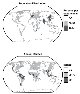
Which of the following statements most accurately interprets information shown in the two maps?

Detailed Solution for UGC NET Paper 2 Geography Mock Test - 9 - Question 29

This question requires the examinee to demonstrate knowledge of the effects of physical factors such as climate, topography, and location on population distribution, patterns of work, industry, agriculture, and transportation. Information presented in the two maps shows that population densities of 0-5 persons per square mile are most common in regions that receive 0-2 inches of rainfall annually.

UGC NET Paper 2 Geography Mock Test - 9 - Question 30

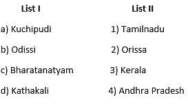
Match list I correctly with list II and select your answer using the codes given below
     

Detailed Solution for UGC NET Paper 2 Geography Mock Test - 9 - Question 30

View more questions
16 docs|120 tests
Information about UGC NET Paper 2 Geography Mock Test - 9 Page
In this test you can find the Exam questions for UGC NET Paper 2 Geography Mock Test - 9 solved & explained in the simplest way possible. Besides giving Questions and answers for UGC NET Paper 2 Geography Mock Test - 9, EduRev gives you an ample number of Online tests for practice

Top Courses for UGC NET

Download as PDF

Top Courses for UGC NET