UGC NET Exam  >  UGC NET Tests  >  UGC NET Mock Test Series 2024  >  UGC NET Paper 2 Geography Mock Test - 4 - UGC NET MCQ

UGC NET Paper 2 Geography Mock Test - 4 - UGC NET MCQ


Test Description

30 Questions MCQ Test UGC NET Mock Test Series 2024 - UGC NET Paper 2 Geography Mock Test - 4

UGC NET Paper 2 Geography Mock Test - 4 for UGC NET 2024 is part of UGC NET Mock Test Series 2024 preparation. The UGC NET Paper 2 Geography Mock Test - 4 questions and answers have been prepared according to the UGC NET exam syllabus.The UGC NET Paper 2 Geography Mock Test - 4 MCQs are made for UGC NET 2024 Exam. Find important definitions, questions, notes, meanings, examples, exercises, MCQs and online tests for UGC NET Paper 2 Geography Mock Test - 4 below.
Solutions of UGC NET Paper 2 Geography Mock Test - 4 questions in English are available as part of our UGC NET Mock Test Series 2024 for UGC NET & UGC NET Paper 2 Geography Mock Test - 4 solutions in Hindi for UGC NET Mock Test Series 2024 course. Download more important topics, notes, lectures and mock test series for UGC NET Exam by signing up for free. Attempt UGC NET Paper 2 Geography Mock Test - 4 | 100 questions in 120 minutes | Mock test for UGC NET preparation | Free important questions MCQ to study UGC NET Mock Test Series 2024 for UGC NET Exam | Download free PDF with solutions
UGC NET Paper 2 Geography Mock Test - 4 - Question 1

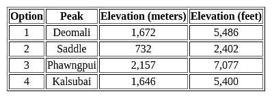
Which among the following is the highest peak of Andaman and Nicobar Islands?

Detailed Solution for UGC NET Paper 2 Geography Mock Test - 4 - Question 1

The correct answer is option 2 Saddle.

Key Points

  • The highest peak of the Andaman and Nicobar Islands is Saddle.
  • The saddle has an elevation of approximately 732 meters (2,402 feet) above sea level.
  • Located on North Andaman Island, Saddle is the highest point in the entire archipelago.
  • It is a part of the Great Nicobar Biosphere Reserve, which is known for its rich biodiversity.
  • The saddle offers stunning views of the surrounding landscapes and is a popular destination for trekkers and nature enthusiasts.

Additional Information

  • Deomali: Deomali is the highest peak in the Indian state of Odisha, not in the Andaman and Nicobar Islands.
  • Phawngpui: Phawngpui, also known as Blue Mountain, is the highest peak in the state of Mizoram, not in the Andaman and Nicobar Islands.
UGC NET Paper 2 Geography Mock Test - 4 - Question 2

A narrow passage of water connecting two large water bodies like seas and oceans is called ________.

Detailed Solution for UGC NET Paper 2 Geography Mock Test - 4 - Question 2

The correct answer is option 4 i.e., Strait.

  • A narrow passage of water connecting two large water bodies like seas and oceans is called strait.
  • Example - Strait of Malacca.
  • A lagoon is a water body separated from larger water bodies by a natural barrier.
  • A narrow strip of land that separates two water bodies and connects two larger landmasses is known as an isthmus.
  • Example - Isthmus of Panama.
  • A broad inlet or a small water body that is set off from a larger water body where the land curves inward is known as a bay.
  • Example- Bay of Bengal.
1 Crore+ students have signed up on EduRev. Have you? Download the App
UGC NET Paper 2 Geography Mock Test - 4 - Question 3

Consider these following statements and choose the correct option.

(A) A population pyramid that is broader at the base indicates an expanding labour force in the future.

(B) A country having a large number of younger children will have an economic advantage in the labour market.

(C) The bottom of the population pyramid reflects the level of deaths while the top reflects the number of births.

Detailed Solution for UGC NET Paper 2 Geography Mock Test - 4 - Question 3

The correct answer is Only (A) is true.

Key Points

  • A population pyramid is a graphical illustration of the distribution by age group and sex.
  • The shape of the pyramid indicates the characteristics of the population.
  • If the pyramid has a broad base, it indicates that a relatively high proportion of the population lives at the youngest age of 0 to 14 years.
  • A broader base indicates an expanding labour force in the future.

Additional Information

  • The population pyramid of a country in which death rates and birth rates are both high is broad at the base and narrows towards the top.

 Thus, we can say that the above statement  A is correct.

UGC NET Paper 2 Geography Mock Test - 4 - Question 4

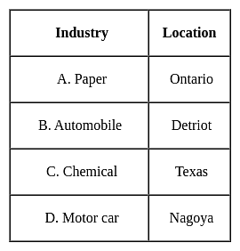
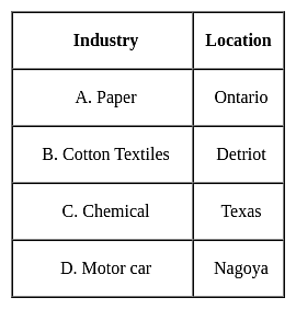
Which one of the following pairs is not correctly matched?
Detailed Solution for UGC NET Paper 2 Geography Mock Test - 4 - Question 4

The correct answer is B.
Key Points

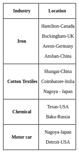
  • The correct order is as follows -

Important Points

  • Other important industrial centers of the world are:-
UGC NET Paper 2 Geography Mock Test - 4 - Question 5

When does most of the rainfall occur over a large part of the Indian region? 

Detailed Solution for UGC NET Paper 2 Geography Mock Test - 4 - Question 5

Answer: Option 3) June-September

Key Points

INDIAN MONSOON:

The Indian region experiences a wide range of climatic conditions, including tropical, subtropical, and temperate climates. The monsoonal climate is one of the most significant features of India's climate, and it is characterized by distinct wet and dry seasons.

  • Option 1: October–November

This option is incorrect. While some parts of India do receive rainfall during October and November, most of the rainfall over a large part of the Indian region occurs during the summer monsoon season.

  • Option 2: December–February

This option is incorrect. The winter months (December-February) are generally dry in most parts of India.

  • Option 3: June–September

This option is correct. Most of the rainfall over a large part of the Indian region occurs during the summer monsoon season, which typically lasts from June to September. Monsoon or rainy season, lasting from June to September. The season is dominated by the humid southwest summer monsoon, which slowly sweeps across the country beginning in late May or early June. Monsoon rains begin to recede from North India at the beginning of October. South India typically receives more rainfall.

  • Option 4: March–May

This option is incorrect. The pre-monsoon season (March-May) is generally characterized by dry and hot weather in most parts of India.

Hence,

The correct answer is Option 3: June–September.

UGC NET Paper 2 Geography Mock Test - 4 - Question 6

Consider the following statements. Identify the right ones: 
I. Monsoon refers the climate associated with seasonal reversal in the direction of winds.
II. India has hot monsoonal climate.

Detailed Solution for UGC NET Paper 2 Geography Mock Test - 4 - Question 6

The term "monsoon" refers to a seasonal reversal in the direction of winds, which is accompanied by significant changes in precipitation patterns. Monsoonal climates are characterized by distinct wet and dry seasons, with the wet season coinciding with the period when the winds blow from the ocean towards the land. India, located in South Asia, experiences a monsoonal climate. 

Key Points

1. Monsoon refers the climate associated with seasonal reversal in the direction of winds.

  •  Monsoon indeed refers to the climate associated with the seasonal reversal in the direction of winds.
  • This seasonal reversal is driven by the differential heating of land and water bodies, which creates pressure gradients that cause winds to change direction.

2. India has hot monsoonal climate.

  • India has the climate of Tropical monsoon due to its peculiar position in the Asian continent and the Indian Ocean.
  • The Indian subcontinent has hot summers and moderately cold winters.
  • In the Himalayas, winters are extremely cold while summers are moderately hot.  This happens due to the differential heating of land and water bodies and pressure situations.
  • In India, the monsoon usually lasts from July to September and 80 to 90 per cent of rainfall is due to the monsoon.

Hence,

The correct answer is Option 3 Both.  Monsoon refers to the climate associated with the seasonal reversal in the direction of winds, and India experiences a monsoonal climate. The statement "India has a hot monsoonal climate" is correct due to its peculiar position in the Asian continent and the Indian Ocean. The Indian subcontinent has hot summers and moderately cold winters.

UGC NET Paper 2 Geography Mock Test - 4 - Question 7
Which one of the following instrument is used for determination of degree of stability or instability of an air parcel?
Detailed Solution for UGC NET Paper 2 Geography Mock Test - 4 - Question 7

 Radiosondes are balloons which fly at different levels to sense different weather phenomena, like stability and unstability of weather. Thus, radiosondes with help of radio waves measure the various weather formations.

Thus, the Correct answer is B.

UGC NET Paper 2 Geography Mock Test - 4 - Question 8

Which of the following states is sole producer of agate, chalk, and perlite in India?

Detailed Solution for UGC NET Paper 2 Geography Mock Test - 4 - Question 8

Gujarat is the sole producer of agate, chalk, and perlite and is leading producer of fluorite (concentrate), fireclay, silica sand, lignite, laterite, petroleum and natural gas and bauxite in the country. State is the sole holder of country’s resources of perlite, 66% of fluorite, 28% of diatomite, 18% of bentonite and 12% of wollastonite. [Ministry of Mines]

So, the correct option is C.

UGC NET Paper 2 Geography Mock Test - 4 - Question 9
Given below are two statements. One is labelled as Assertion (A) and the other is labelled as Reason (R).

Assertion(A)- According to Anthony Giddens human agency and social structure are not two separate concepts.

Reason(R)- Structure is a continuous process which is carried out in a flow.

Select the correct answer from options given below:

Detailed Solution for UGC NET Paper 2 Geography Mock Test - 4 - Question 9

Structuration theory was majorly propounded by Giddens and Bourdieu. According to Giddens human agency and social structure are not two separate concepts or constructs, but these are together produced by social action and interaction. He states it as an outcome of a continuous process or flow of process.

Thus, the Correct answer is A.

UGC NET Paper 2 Geography Mock Test - 4 - Question 10
Whose stream ordering technique is most often considered in drainage basin studies?
Detailed Solution for UGC NET Paper 2 Geography Mock Test - 4 - Question 10

The stream order method by Strahler is the most common technique used in various applications. Here, the small permanent streams are called 1st order streams. Two 1st order streams join to form a larger order, second order stream; two 2nd order streams join to form a 3rd order and so on.

UGC NET Paper 2 Geography Mock Test - 4 - Question 11
Which types of weather is mainly witnessed in the case of anticyclones?
Detailed Solution for UGC NET Paper 2 Geography Mock Test - 4 - Question 11

The convergence of air towards the centre accompanied by lift of air and adiabatic cooling which produces cloudiness and precipitation in cyclone and on the other hand much fair and sunny weather is associated with travelling anticyclones in which the air tends to subside and spread outward, causing adiabatic warning, a progress that is unfavourable to the development of clouds and precipitation.

Thus, the Correct answer is A .

UGC NET Paper 2 Geography Mock Test - 4 - Question 12

Consider the following statements about anticyclones :
1. Anticyclones are high pressure systems.
2. Air in the centre of the system must be subsiding.
3. Anticyclones are characterized by converging winds.

How many of the above statements is/are correct?

Detailed Solution for UGC NET Paper 2 Geography Mock Test - 4 - Question 12

The correct answer is 2.

Key Points

Anticyclones:

  • Anticyclones are centres of high pressure. Hence, statement 1 is correct.
  • They are surrounded by closed isobars having decreasing pressure outward.
  • The circulation is from central high pressure towards the periphery in such a way that air blows outwards in a clockwise direction in the Northern hemisphere and anticlockwise direction in the southern hemisphere.
  • Due to Coriolis force, blowing winds are deflected from their paths to the right in the Northern hemisphere and left in the Southern hemisphere,  that’s how it gets circular with a flowing system.
  • The difference in pressure between the centre and periphery of anticyclone ranges between 10 to 20 mb and sometimes higher.
  • There are much larger in size and area than temperate cyclones as the diameter is 75% larger than that of temperate cyclones.
  • Anticyclones originated due to the descent of either polar cold air mass or warm tropical air mass.
  • These anticyclones are high-pressure systems and are more common in subtropical high-pressure belts and polar high-pressure belts where the air is sinking from the upper troposphere to the lower troposphere but are practically absent in equatorial regions(centre). Hence, statement 2 is correct.
  • Anticyclones are characterized by diverging winds. Hence, statement 3 is not correct.

Hence 2 statements are correct. (Statement 1 & 2)

UGC NET Paper 2 Geography Mock Test - 4 - Question 13
A greenhouse gas like CO2, absorbs:
Detailed Solution for UGC NET Paper 2 Geography Mock Test - 4 - Question 13

Concept:

Greenhouse gas:

  • carbon dioxide and methane are commonly known as greenhouse gases.
  • Because they are responsible for the greenhouse effect.

Explanation:

Greenhouse effect: 

  • The greenhouse effect is a naturally occurring phenomenon that is responsible for the heating of the Earth’s surface and atmosphere.
  • Clouds and gases reflect about one-fourth of the incoming solar radiation and absorb some of it but almost half of the incoming solar radiation falls on Earth’s surface heating it, while a small proportion is reflected back.
  • Earth’s surface re-emits heat in the form of infrared radiation but part of this does not escape into space as atmospheric greenhouse gases (e.g., carbon dioxide, methane, etc.) absorb a major fraction of it.
  • The molecules of these gases radiate heat energy a major part of which again comes to Earth’s surface, thus heating it up once again.
  • An increase in the level of greenhouse gases has led to considerable heating of the Earth leading to global warming.

Thus, a greenhouse gas like CO2 absorbs heat.

Additional InformationMoisture:

  • The presence of a liquid, especially water, even in minute amounts, is referred to as moisture.
  • For instance, little amounts of water can be found in the air, food, etc.
  • The amount of water vapour in the air is also referred to as moisture.

Oxygen:

  • The chemical element with the atomic number 8 and symbol O is called oxygen.
  • Approximately 78% of the air in Earth's atmosphere is nitrogen, while 21% is oxygen.

Hydrogen:

  • While hydrogen is abundant on Earth in combination with other elements, such as in water and hydrocarbons.
  • It is incredibly rare and only makes up 0.00005 per cent of our atmosphere.
UGC NET Paper 2 Geography Mock Test - 4 - Question 14

Which Indian state produces the largest quantity of pulses?

Detailed Solution for UGC NET Paper 2 Geography Mock Test - 4 - Question 14

The correct answer is Madhya Pradesh.

Key Points

  • Madhya Pradesh is the largest producer of pulses in India at 24.7% of total production.
  • India is the largest producer (25% of total production), a consumer (27% of world consumption), and an importer (14%) of pulses in the world.
  • Madhya Pradesh (24.7%) is the largest pulse producer followed by Maharashtra (15%) and Rajasthan (12.4%).
  • India ranks first in the Global average under pulses accounting for 35% of the global average.
  • Dominant Rabi and Kharif pulses are Gram (72%) and Tur/Arhar (48%) in terms of production.
  • Pulses:
    • These are a major source of protein.
    • These have low-fat content and high fiber content.
    • These are Grown in both the rabi season and the Kharif season.

Additional Information

  • Major Kharif pulses include:

  • Major rabi/summer pulses include:

UGC NET Paper 2 Geography Mock Test - 4 - Question 15
A recurring climate pattern involving changes in the temperature of waters in the central and eastern tropical Pacific Ocean is known as:
Detailed Solution for UGC NET Paper 2 Geography Mock Test - 4 - Question 15

The correct answer is ENSO

Key Points

  • The El Niño-Southern Oscillation (ENSO) is a recurring climate pattern involving changes in the temperature of waters in the central and eastern tropical Pacific oceans.
  • The Southern Oscillation is a change in air pressure over the tropical Pacific Ocean.
  • When coastal waters become warmer in the eastern tropical Pacific (El Niño), the atmospheric pressure above the ocean decreases.
  • El Niño and La Niña are the extreme phases of the ENSO cycle; between these two phases is a third phase called ENSO-neutral.
Additional Information
  • ENSO is one of the most important climate phenomena on Earth due to its ability to change the global atmospheric circulation, which in turn, influences temperature and precipitation across the globe.
  • El Niño:
    • A warming of the ocean surface, or above-average sea surface temperatures (SST), in the central and eastern tropical Pacific Ocean.
    • Over Indonesia, rainfall tends to become reduced while rainfall increases over the central and eastern tropical Pacific Ocean.
    • In general, the warmer the ocean temperature anomalies, the stronger the El Niño.
  • La Niña:
    • Cooling of the ocean surface, or below-average sea surface temperatures (SST), in the central and eastern tropical Pacific Ocean.
    • Over Indonesia, rainfall tends to increase while rainfall decreases over the central and eastern tropical Pacific oceans. The normal easterly winds along the equator become even stronger.
    • In general, the cooler the ocean temperature anomalies, the stronger the La Niña (and vice-versa).
  • Neutral:
    • Neither El Niño or La Niña. Often tropical Pacific SSTs are generally close to average.
    • However, there are some instances when the ocean can look like it is in an El Niño or La Niña state, but the atmosphere is not playing along (or vice versa).
UGC NET Paper 2 Geography Mock Test - 4 - Question 16
Harmattan' warm and dry wind is a local wind found in
Detailed Solution for UGC NET Paper 2 Geography Mock Test - 4 - Question 16

The correct answer is the Sahara desert of Africa.

Key Points

  • Harmattan wind
    • It is found over the Sahara desert of Africa during summer.
    • It changes warm and moisture climatic conditions of the western coast of Africa into warm and dry.
    • These are also called doctor winds.
    • It reduces the visibility to zero.

Additional Information

  • Norwester is a warm wind found in New Zealand.
  • Santa Ana is a warm wind found in South California.
  • Chinook is the warm and dry wind blowing on the leeward side Rocky Mountains.
UGC NET Paper 2 Geography Mock Test - 4 - Question 17
The Red Data Book which lists the endangered species is maintained by which of the following organisation?
Detailed Solution for UGC NET Paper 2 Geography Mock Test - 4 - Question 17

The Red Data Book which lists the endangered species is maintained by IUCN.

Important Points

The International Union for Conservation of Nature (IUCN) maintains the Red List of Threatened Species, also known as the Red Data Book. This list is the world's most comprehensive inventory of the global conservation status of plant and animal species.

Red Data Books:

  • The "Red Data Books" published by the International Union for Conservation of Nature and Natural Resources (IUCN) is the world's most comprehensive inventory of the global conservation status of plant and animal species.
  • A red data book is beneficial for providing detailed information for studies and research. It also helps in monitoring programs on rare and endangered species. It thus helps in protecting the species that are on the verge of extinction
  • IUCN is a network of environmental organizations founded as the International Union for the Protection of Nature in October 1948 in Fontainebleau, France.
  • It promotes nature conservation and the ecologically sustainable use of natural resources.
  • It changed its name to the International Union for Conservation of Nature and Natural Resources (IUCN) in 1956.
  • IUCN is composed of both government and civil society organizations which harness the experience, and resources.
  • Headquarters: Gland, Switzerland.
  • The IUCN maintains the IUCN Red List of Threatened Species, which was established in 1964.
  • IUCN also played a fundamental role in the creation of key international conventions, including the Ramsar Convention on Wetlands (1971), the World Heritage Convention (1972), the Convention on International Trade in Endangered Species, (1974), and the Convention on Biological Diversity (1992), UNFCCC, etc.
  • Caring for the Earth was published by the three organizations in the run-up to the 1992 Earth Summit.

Additional Information

UNO: The United Nations Organization (UNO)

  • It is an intergovernmental organization that was established in 1945 after World War II to promote international peace, security, and cooperation.
  • It is composed of member states from around the world and has various specialized agencies, programs, and funds that work on a wide range of issues, including human rights, economic development, health, and the environment.

WHO: The World Health Organization (WHO)

  • It is a specialized agency of the United Nations that is concerned with international public health.
  • It was established in 1948 and is responsible for providing leadership on global health matters, shaping the health research agenda, setting norms and standards, articulating evidence-based policy options, and monitoring and assessing health trends.

WWF: The World Wildlife Fund (WWF)

  • It is an international conservation organization that works to protect the environment and endangered species.
  • It was established in 1961 and has worked to protect biodiversity, conserve natural habitats, reduce pollution and wasteful consumption, and promote sustainable development.
  • The WWF operates in over 100 countries and has been instrumental in the creation of protected areas and the conservation of endangered species, such as pandas, tigers, and elephants.
UGC NET Paper 2 Geography Mock Test - 4 - Question 18
According to World Human Development Index-2013, the rank of India was
Detailed Solution for UGC NET Paper 2 Geography Mock Test - 4 - Question 18

India ranked 135 on Human Development Index in 2013.

Key Points

  • The HDI was created to shift conversations about development progress away from GDP and toward a metric that really counts on the lives of individuals.
  • The Human Development Index (HDI) was developed by the Human Development Report Office (HDRO) in 1990 to offer a straightforward indicator of human progress.
  • The HDI is based on the freedom of individuals to lead the lives they choose and has become well-known for its straightforward yet thorough formula that evaluates a population's average longevity, education, and income.

Additional Information

  • A long and healthy life, access to information, and a reasonable level of living are the three fundamental elements of human development that the HDI measures in summary form over time.
  • Life expectancy is a measure of a long and healthy life.
  • Access to learning and knowledge is measured by expected years of schooling for children of school-entry age, which is the total number of years of schooling a child of school-entry age can expect to receive if current patterns of age-specific enrolment rates remain constant throughout the year. The knowledge level is determined by mean years of schooling among the adult population, which is the average number of years of schooling received in a lifetime by people aged 25 years and older.
  • Gross National Income (GNI) per capita expressed in constant 2017 foreign dollars converted using purchasing power parity (PPP) conversion rates is a measure of standard of life.

Thus we know that India ranked 135 on Human Development Index in 2013.

UGC NET Paper 2 Geography Mock Test - 4 - Question 19

Consider the following statements regarding the Remote Sensing Survey:

1) Information transfer is accomplished by the use of electromagnetic radiation

2) Remote Sensing from space is done by satellites

3) Remote Sensing has no application in Earthquake prediction

Which of the above statements are correct?

Detailed Solution for UGC NET Paper 2 Geography Mock Test - 4 - Question 19

Remote sensing survey:

It is the art and science of obtaining information about an object or feature without physically coming in contact with that object.

Characteristics of remote sensing

  1. The data collected using it is in various forms such as variations in acoustic wave distributions (SONAR), variations in force distributions (gravity meter), variations in electromagnetic energy distributions.
  2. The remote sensing is the process of inferring surface parameters from measurements of the electromagnetic radiation (EMR) from the Earth’s surface.
  3. In space-borne remote sensing, sensors are mounted on a satellite orbiting the earth.

Advantages of remote sensing are:

  1. The current situation of remote sensing application for earthquake research indicates a few phenomena, related with earthquakes, particularly the Earth's surface deformation, surface temperature and humidity, atmosphere temperature and humidity, gas and aerosol content. Both horizontal and vertical deformations scaled from tens of centimeters to meters are recorded after the shock
  2. Remote sensing provides data on large areas.
  3. It can be used to obtain data of very remote and inaccessible regions.
  4. It is relatively cheap when compared to employing a team of surveyors.
  5. Easy and rapid collection of data.
  6. Rapid production of maps for interpretation.
UGC NET Paper 2 Geography Mock Test - 4 - Question 20
Which is the shallowest part of the ocean, showing an average gradient of 1° or even less and it typically ends at a very steep slope?
Detailed Solution for UGC NET Paper 2 Geography Mock Test - 4 - Question 20

The correct answer is Continental Shelf.

Key Points

  • Continental Shelf is the shallowest part of the ocean, showing an average gradient of 1° or even less and it typically ends at a very steep slope.
  • Continental Shelf:
    • It is the gently sloping seaward extension of the continental plate.
    • It is the shallowest part of the ocean.
    • These are created due to sedimentation from the continents.
    • Continental Shelf is the gently sloping seaward extension of the continental plate.
    • The continental shelves are covered with variable thicknesses of sediments brought down by rivers, glaciers, etc.
    • The shelves are almost absent or very narrow along some of the margins like the coasts of Chile, the west coast of Sumatra, etc. [Ocean - Continent Convergence and Ocean - Ocean Convergence].
    • Continental shelves are located in photic zones, so have rich marine ecology.
    • The Continental Shelf of all oceans together covers 7.5% of the total area of the oceans.

Additional Information

  • Ocean Floor Division can be divided into various parts such as Continental Shelf, Continental Slope, Continental Rise or Foot, Deep Ocean basins, Abyssal plains or Deep Sea plain, Oceanic Trenches, Seamounts, and Guyots.
  • Deep-Sea Plain or Abyssal plain:
    • These plains are gently sloping areas of the ocean basins.
    • These are the flattest and smoothest regions of the world.
    • It is an underwater plain on the deep ocean floor, usually found at depths between 3,000 and 6,000m.
    • These plains are covered with fine-grained sediments like clay and silt.
    • Lying generally between the foot of a continental rise and a mid-ocean ridge, abyssal plains cover more than 50% of the Earth's surface.
  • Oceanic Deeps or Trenches:
    • These areas are the deepest parts of the oceans.
    • The trenches are relatively steep-sided, narrow basins.
    • They are some 3-5 km deeper than the surrounding ocean floor.
    • They occur at the bases of continental slopes and along island arcs and are associated with active volcanoes and strong earthquakes.
  • Continental Slope:
    • The continental slope ties the continental shelf and the rising of the continent.
    • The continental shelf stops as the slope rises sharply. From here, the continental slope begins.
    • A sudden change in the gradient to around 1 in 20 occurs. With young mountain ranges and narrow continental shelves, the slope gradient is highest off coasts and lowest off stable coasts without large rivers.
    • Most Pacific slopes are steeper than Atlantic slopes.
UGC NET Paper 2 Geography Mock Test - 4 - Question 21

Which of the following is/are true about the Amazon basin?

(A) The river Nile flows through this region.

(B) Both days and nights weather is almost equally hot and humid here.

(C) At night, the temperature goes down, but the humidity remains high.

Choose the correct option.

Detailed Solution for UGC NET Paper 2 Geography Mock Test - 4 - Question 21

The correct answer is (B) and (C) are true.

Key Points

  • The correct answer for the question is option 4, which is "(B) and (C) are true".
  • Explanation:
    • Option (A) is incorrect because the river Nile doesn't flow through the Amazon basin.
    • The Amazon River is the main river in this region.
    • Option (B) is true because the Amazon basin has a tropical climate with high temperatures and humidity throughout the year.
    • Option (C) is also true because although the temperature drops at night, the humidity remains high in the Amazon basin due to the region's dense forest cover and proximity to the equator.

Additional Information

  • The Amazon basin is located in South America and covers an area of approximately 7 million square kilometers.
  • The region is known for its dense rainforest and diverse wildlife, including species like jaguars, anacondas, and macaws.
  • The Amazon River is the second longest river in the world and is a significant source of freshwater for the region.
UGC NET Paper 2 Geography Mock Test - 4 - Question 22

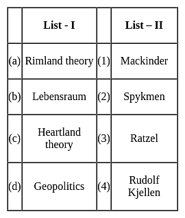
Match the concepts (List - I) with their proponents (List - II) selecting correct answer from the codes given below :
Detailed Solution for UGC NET Paper 2 Geography Mock Test - 4 - Question 22

The correct answer is (a) - (2), (b) - (3), (c) - (1), (d) - (4)

Key Points

  • Heartland theory was given by British political geographer H J Mackinder in the year 1904. "The Geographical Pivot of History" is an article submitted by Halford John Mackinder in 1904 to the Royal Geographical Society that advances his heartland theory. In this article, Mackinder extended the scope of geopolitical analysis to encompass the entire globe.
  • Heartland theory believed that whoever controls the heartland( Siberia and part of central Asia) will control the world islands whereas rimland theory believed that whoever controls the rimland (Inner marginal crescent) comprised Europe, North Africa, West Asia, India, South East Asia, and part of China will control the world islands
  • Spykeman propounded the Rimland theory in opposition to the Heartland theory of Mackinder. Spykman proposed a theory that countered Mackinder's Heartland Theory. According to his rimland theory, the coastal areas or littorals of Eurasia are key to controlling the World Island, not the Heartland. As per Spykman, landlocked states usually faced security challenges from their immediate neighbors.
  • The ideology of Nazism Party workers and also Adolf Hitler was Lebensraum which meant that the living space or territory area extended to enable the material resources and the power of the German Nation and also established the new territory for their people settlement.
  • The term Lebensraum was coined by the German geographer, Friedrich Ratzel (1844-1904). During the last two decades of the 19th century, Ratzel developed a theory according to which the development of all species, including humans, is primarily determined by their adaptation to geographic circumstances.
  • Geopolitics, analysis of the geographic influences on power relationships in international relations.
  • The word geopolitics was originally coined by the Swedish political scientist Rudolf Kjellén about the turn of the 20th century, and its use spread throughout Europe in the period between World Wars I and II (1918–39) and came into worldwide use during the latter.
UGC NET Paper 2 Geography Mock Test - 4 - Question 23
Read the following statements and select the correct answer from the code given below.

(a) Ratzel applied organic theory to biogeography.

(b) Humboldt was of the opinion that life of people living in islands, plains and mountains was similar.

(c) Kant described the impact of environment in late 18th century.

(d) Darwin’s theory of origin of species is dependent on the idea that the nature changes with time.

Code:

Detailed Solution for UGC NET Paper 2 Geography Mock Test - 4 - Question 23

Ratzel developed the concept of Lebensraum (living space). In that he applied the concepts of organic theory to Political Geography. Humboldt travelled extensively through the world and noted that the mode of life was different in different places, such as coastal plains differed from islands, river basins or mountainous regions. Immanuel Kant, in 18th century concluded from his research that environment had a huge impact on human lifestyle. Charles Darwin, in his book Origin of species claimed that things in nature change with time.

Thus, the correct answer is D.

UGC NET Paper 2 Geography Mock Test - 4 - Question 24

Which of the following statements represent the Peninsular River system?

a) This is a consequent drainage river system

b) The rivers receive water only from rainfall.

c) They follow more or less straight courses.

d) These rivers form big deltas at their mouths.

Select the correct option-

Detailed Solution for UGC NET Paper 2 Geography Mock Test - 4 - Question 24


Statements a, b and c are correct in the case of Peninsular Rivers as they have those characteristics. Firstly, these rivers flow in comparatively shallow and graded valleys. The rivers have little erosional activity to perform and hence these suggest a consequent drainage. Secondly, the rivers are seasonal and non-perennial. Water flows through these rivers only during the rainy season. Thirdly, the hard rock surface and non-alluvial character of the plateau does not allow for the formation of meanders and hence they follow a more or less straight course.

  • The major rivers of the peninsula, such as the Mahanadi, Godavari, Krishna, and Cauvery, predominantly flow eastward and discharge into the Bay of Bengal, forming deltas at their mouths.


UGC NET Paper 2 Geography Mock Test - 4 - Question 25
Given below are two statements, one labelled as assertion(A) and other labelled as reason(R).

Assertion(A)- Principal component analysis identifies duplicate data over several datasets.

Reasoning(R)-It aggregates only essential information .

Detailed Solution for UGC NET Paper 2 Geography Mock Test - 4 - Question 25

Sometimes, variables are highly correlated in such a way that it would be duplicate information found in another variable. Principal component analysis identifies duplicate data over several datasets. It creates a new dataset with only the essential information.

Thus, the correct answer is A.

UGC NET Paper 2 Geography Mock Test - 4 - Question 26

Match List-I with List-II

Code:

Detailed Solution for UGC NET Paper 2 Geography Mock Test - 4 - Question 26
  • Humid Warm Summer climate is denoted by Da. It has hot summers. Summers are ideal for rapid growth of crops. Winters have very less vegetation.
  • Dry subtropical climate is also called Mediterranean climate. It is shown by abbreviation Cs and covers 1.7% of world’s total area. Winters here are mild and rainy while summers are hot and dry.
  • Tropical desert is shown with abbreviation BWh. The average rainfall here is less than 35 cm. There is little vegetation and most of it is drought resistant. Thar Desert in Rajasthan is an example of BWh climate.
  • The Aw is the Tropical Savannah Climate. It has alternate wet and dry seasons. The length of the day and night is nearly equal. Total annual rainfall is between 100 and 150 cm.

Thus, the correct answer is C.

UGC NET Paper 2 Geography Mock Test - 4 - Question 27
Which of the following agro-climatic regions practices shifting agriculture?
Detailed Solution for UGC NET Paper 2 Geography Mock Test - 4 - Question 27

The Eastern Himalayan region has rugged topography, steep slopes, thick forests and swift flowing rivers. The area has red brown soil and has shifting cultivation. It is called jhumming locally. Rice, maize, potato and fruits are the main crops here.

UGC NET Paper 2 Geography Mock Test - 4 - Question 28
Who propounded the concept of paradigm?
Detailed Solution for UGC NET Paper 2 Geography Mock Test - 4 - Question 28

There have been various evolutionary phases in geography. It passed from descriptive and teleological phase to the quantitative radical and dialectical materialism stage. There was a shift of approaches that were conventionally used to a set of new ways of approaches. This was called paradigm which was for the first time propounded by Thomas Kuhn in 1962.

UGC NET Paper 2 Geography Mock Test - 4 - Question 29

Match List-I with List-II and select the correct answer from the codes given below :

Choose the correct option from below:

Detailed Solution for UGC NET Paper 2 Geography Mock Test - 4 - Question 29

Post modernism is an approach in human geography. It is against the concept of modernism and rejects all the statements the theory gives.

La condition postmorderne was the work of Jean Francois Lyotard.

Madness and civilization is the work of Michel Foucalt.

Postmodern Ethics is the work of Zygmunt Bauman.

Approaches to human geography is the work of Aitken S.

UGC NET Paper 2 Geography Mock Test - 4 - Question 30

In an ecotone, the species which become abundant are called:

Detailed Solution for UGC NET Paper 2 Geography Mock Test - 4 - Question 30

An ecotone is a transition area between two biomes but different patches of the landscape, such as forest and grassland. The ecotone contains not only species common to the communities on both sides; it may also include a number of highly adaptable species that tend to colonize such transitional areas. This can produce an edge effect along the boundary line, with the area displaying a greater than usual diversity of species. The phenomenon of increased variety of plants as well as animals at the community junction is called the “edge effect” and is essentially due to a locally broader range of suitable environmental conditions or ecological niches.

View more questions
16 docs|120 tests
Information about UGC NET Paper 2 Geography Mock Test - 4 Page
In this test you can find the Exam questions for UGC NET Paper 2 Geography Mock Test - 4 solved & explained in the simplest way possible. Besides giving Questions and answers for UGC NET Paper 2 Geography Mock Test - 4, EduRev gives you an ample number of Online tests for practice

Top Courses for UGC NET

Download as PDF

Top Courses for UGC NET