BSF Head Constable Mock Test - 7 - BSF Head Constable MCQ
30 Questions MCQ Test BSF Head Constable Mock Test Series 2024 - BSF Head Constable Mock Test - 7
It is a political organisation that subscribes to a particular ideology and seeks to attain political power
Who was the Viceroy of India when the Rowlatt Act was passed?
| 1 Crore+ students have signed up on EduRev. Have you? Download the App |
Who was the first Indian batsman to hit a century on Test debut against England at England's home?
The major harmful gas emitted by automobile vehicles which causes air pollution is –
In which year, the 73rd Constitutional Amendment Act (1972) was assented by the President?
What was the purpose of the Maritime Partnership Exercise (MPX) conducted by India and France in the Bay of Bengal?
Who has been appointed as the Chief Financial Officer (CFO) of State Bank of India (SBI)?
What was the theme of the UAE-India Economic Summit held in Abu Dhabi?
Who has been re-appointed as the Solicitor General of India?
Which state-owned coal mining major appointed PM Prasad as its Chairman and Managing Director (CMD)?
60 litres of a 75% solution of wine is taken into a laboratory. 4 litres of the solution is flushed and 4 litres of water is added to compensate the loss. Then 5 litres of the solution is flushed again and 5 litres of water is added. Again 6 litres of the solution is flushed and 6 litres of water is added. The final concentration of wine in the solution is
A vessel contains a mixture of two liquids A and B in the ratio of 4:1. When 10 litres of the mixture is replaced with liquid B, the ratio becomes 2:3. How many litres of liquid A was present in the jar initially?
Twenty workers can finish a piece of work in 30 days. After how many days should 5 workers leave the job so that the work is completed in 35 days?
Subhash can copy 50 pages in 10 hours; Subhash and Prakash together can copy 300 pages in 40hours. In how much time can Prakash copy 30 pages?
If the places of last two-digits of a three digit number are interchanged, a new number greater than the original number by 36 is obtained. What is the difference between the last two digits of that number?
Three buckets contains balloons filled with water. First bucket contains 243 balloons. Second contains 304 balloons and last bucket contains 127 balloons. Find the largest number of balloons that can be given equally to the children such that 3, 4 and 7 balloons are left in first, second and third bucket respectively?
40% of the women are above 30 years of age and 80 percent of the women are less than or equal to 50 years of age. 20 percent of all women play basketball.If 30 percent of the women above the age of 50 plays basketball, what percent of players are less than or equal to 50 years?
Of all the students in a certain dormitory, half are first-year students and the rest are second-year students. If 4/5 of the first-year students have not declared a major and the fraction of second-year students who have declared a major is 3 times the fraction of the first-year students who have declared a major, then what fraction of all the students in the dormitory are second-year students who have not declared a major?
If the cost price of 15 tables is equal to the selling price of 20 tables, then the loss percentage in the transaction is
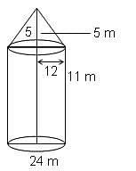
A tent is in the form of a right circular cylinder surmounted by a cone. The diameter of the cylinder is 24 m. The height of the cylindrical portion is 11 m, while the vertex of the cone is 16 m above the ground. What is the area of the curved surface for the conical portion?

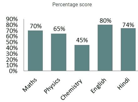
Directions: Study the following bar chart carefully and answer the questions given beside.
The chart given below shows the percentage marks of a student in five different subjects. The maximum marks in each subject are 150.

Q. The total marks deducted in Maths and Hindi is what percent of the score obtained in Maths?
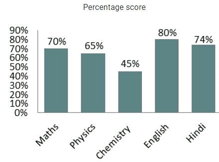
Directions: Study the following bar chart carefully and answer the questions given beside.
The chart given below shows the percentage marks of a student in five different subjects. The maximum marks in each subject are 150.

Q. What is the aggregate percentage score of all the subjects combined?
Find the word most appropriate for Blank no. 20
The (11)____ citizen who has to get everyday jobs done by various municipal and government departments is (12)____ driven up a tree, first (13)____ them, second explaining to them what is (14)____ and lastly, getting the job done.
If this week I (15)____ some personal experience in this column, it is because I can document them. It is not to ask for any special (16)____ or voice personal (17)____ but to bring into public view the experience of hundreds, if not thousands of citizens everyday of the year and express the collective (18)____ of all of them. Because one’s usual experience is that when such complaints are (19)____ in such columns, the departments rush to (20)____
DIRECTIONS: The following question contains an idiom and its usage in a sentence, followed by four possible meanings labelled A, B, C, and D. Pick out the right meaning of the idiom in question and mark your answer accordingly.
Q.
On the wane.
The days of this actor are "on the wane".
DIRECTIONS: The following question contains an idiom and its usage in a sentence, followed by four possible meanings labelled A, B, C, and D. Pick out the right meaning of the idiom in question and mark your answer accordingly.
Q.
Elbow grease.
He has reached this high stature through "elbow grease".
Direction: The sentences given in the question, when properly sequenced, form a coherent paragraph. Each sentence is labeled with a letter. Choose the most logical order of sentences from the given choices to construct a coherent paragraph.
A. Not long after their victory, the Greeks began to think that they would never stack up to the glories of the past.
B. Throughout antiquity, those warriors, especially the Marathonomachai, who fought and defeated the Persian troops in the 490 BCE Battle of Marathon, would be revered as Athens’ Greatest Generation.
C. Even in the mid-fifth century BCE, Athenians were already looking back with longing.
D. A few decades earlier, Athenian citizen-soldiers had helped to rout the Persian invaders of Greece.
Directions: Read the following passage carefully and answer the questions given beside.
Remote sensing and GIS are promising tools for handling spatial and temporal data and help in integrating them for successful planning of natural resources. It is the science of measuring the earth using sensors mounted on high-flying aircrafts or satellites. These sensors collect data in the form of images and provide insights for manipulating, analysing and visualising those images. Since natural resources are not uniformly distributed and are spatially varied, it is challenging to capture the correct picture. Management of natural resources calls for scientific tools for timely and accurate dissemination of information. In natural resource management, remote sensing and GIS are mainly used in the mapping process. These techniques are useful in management of land, soil, coastal, watershed, urban and many more.
In India, the agriculture sector alone sustains the livelihood of around 50 percent of the population. Therefore, an increase in crop productivity has been a major concern. Since, the scope for increasing area under agriculture is limited, advanced crop production forecasting is required for better policymaking. Indian Space Research Agency (ISRO) and Indian Council of Agricultural Research (ICAR) successful experiment-Agricultural Resource Inventory and Survey Experiment (ARISE) used aerial colour photographs to estimate crop acreage in many states of India. Other Important uses of remote sensing include crop identification, stress detection, and crop yield modelling, drought monitoring, land degradation mapping and more. Urbanisation is important and inevitable for development, but its proper planning and management is crucial for sustenance. One of the important features of GIS is multilayered mapping. This kind of mapping helps municipal corporations, town planning boards to build cities that are better organised. The information systems with socio-economic data overlaid upon satellite data makes urban planning cost-effective and accurate.
Coastal ecosystems have high ecological significance. GIS and remote sensing data are used to study coastal ecosystems and marine living resources which include habitats like mangroves, coral reefs and more. Apart from this, suspended shoreline dynamics can be studied and climatic changes leading to cyclones and sea level rise may be of special interest too. Geospatial data is effective in the analysis and determination of factors that affect the utilisation of these resources. The technologies provide a platform through which we can generate information that can be used to make sound decisions for sustainable development of the natural resources of India.
Q. In the given context of the passage, why are GIS and remote sensing tools crucial in the agriculture sector?
I. This sector alone sustains the livelihood of around 50 percent of the population.
II. GIS and remote sensing would help in advanced crop production forecasting.
III. Drought monitoring can be done using GIS and remote sensing tools.
Directions: Read the following passage carefully and answer the questions given beside.
Remote sensing and GIS are promising tools for handling spatial and temporal data and help in integrating them for successful planning of natural resources. It is the science of measuring the earth using sensors mounted on high-flying aircrafts or satellites. These sensors collect data in the form of images and provide insights for manipulating, analysing and visualising those images. Since natural resources are not uniformly distributed and are spatially varied, it is challenging to capture the correct picture. Management of natural resources calls for scientific tools for timely and accurate dissemination of information. In natural resource management, remote sensing and GIS are mainly used in the mapping process. These techniques are useful in management of land, soil, coastal, watershed, urban and many more.
In India, the agriculture sector alone sustains the livelihood of around 50 percent of the population. Therefore, an increase in crop productivity has been a major concern. Since, the scope for increasing area under agriculture is limited, advanced crop production forecasting is required for better policymaking. Indian Space Research Agency (ISRO) and Indian Council of Agricultural Research (ICAR) successful experiment-Agricultural Resource Inventory and Survey Experiment (ARISE) used aerial colour photographs to estimate crop acreage in many states of India. Other Important uses of remote sensing include crop identification, stress detection, and crop yield modelling, drought monitoring, land degradation mapping and more. Urbanisation is important and inevitable for development, but its proper planning and management is crucial for sustenance. One of the important features of GIS is multilayered mapping. This kind of mapping helps municipal corporations, town planning boards to build cities that are better organised. The information systems with socio-economic data overlaid upon satellite data makes urban planning cost-effective and accurate.
Coastal ecosystems have high ecological significance. GIS and remote sensing data are used to study coastal ecosystems and marine living resources which include habitats like mangroves, coral reefs and more. Apart from this, suspended shoreline dynamics can be studied and climatic changes leading to cyclones and sea level rise may be of special interest too. Geospatial data is effective in the analysis and determination of factors that affect the utilisation of these resources. The technologies provide a platform through which we can generate information that can be used to make sound decisions for sustainable development of the natural resources of India.
Q. What can be the most appropriate title for the passage?
Directions: Out of the given alternatives, choose the one which can be substituted for the given words/sentence.
Made or done without previous preparation


