TS TET Exam  >  TS TET Tests  >  TS SET Mock Test Series 2024  >  TS SET Paper 2 Mock Test - 7 (Geography) - TS TET MCQ

TS SET Paper 2 Mock Test - 7 (Geography) - TS TET MCQ


Test Description

30 Questions MCQ Test TS SET Mock Test Series 2024 - TS SET Paper 2 Mock Test - 7 (Geography)

TS SET Paper 2 Mock Test - 7 (Geography) for TS TET 2024 is part of TS SET Mock Test Series 2024 preparation. The TS SET Paper 2 Mock Test - 7 (Geography) questions and answers have been prepared according to the TS TET exam syllabus.The TS SET Paper 2 Mock Test - 7 (Geography) MCQs are made for TS TET 2024 Exam. Find important definitions, questions, notes, meanings, examples, exercises, MCQs and online tests for TS SET Paper 2 Mock Test - 7 (Geography) below.
Solutions of TS SET Paper 2 Mock Test - 7 (Geography) questions in English are available as part of our TS SET Mock Test Series 2024 for TS TET & TS SET Paper 2 Mock Test - 7 (Geography) solutions in Hindi for TS SET Mock Test Series 2024 course. Download more important topics, notes, lectures and mock test series for TS TET Exam by signing up for free. Attempt TS SET Paper 2 Mock Test - 7 (Geography) | 100 questions in 120 minutes | Mock test for TS TET preparation | Free important questions MCQ to study TS SET Mock Test Series 2024 for TS TET Exam | Download free PDF with solutions
TS SET Paper 2 Mock Test - 7 (Geography) - Question 1

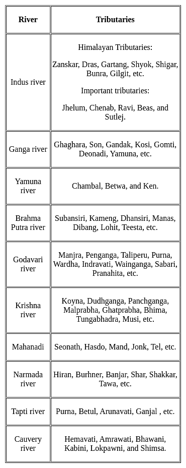
The Koyna, Tungabhadra and Bhima rivers are the major tributaries of the river ___________.

Detailed Solution for TS SET Paper 2 Mock Test - 7 (Geography) - Question 1

The correct answer is Krishna.

Key Points

TS SET Paper 2 Mock Test - 7 (Geography) - Question 2

Which one of the following is not a result of erosion by running water?

Detailed Solution for TS SET Paper 2 Mock Test - 7 (Geography) - Question 2

The correct answer is Natural levees.Key Points

  • Natural levees are a depositional feature found along the banks of large rivers.
  • These are ridges of coarse deposits lying parallel to the river.

Important Points

  • Valleys are formed due to erosion by the river.
    • The river widens and deepens the floor to make valleys.
  • A canyon is a kind of valley that is wide at its top than at its bottom.
    • These are formed in horizontal bedded sedimentary rocks.

Additional Information

  • Other erosional features made by running water are:
    • Gorges, potholes, plunge pools, river terraces.
  • Other depositional features made by running water are:
    • ​Alluvial fans, deltas, floodplains, point bars, meanders, oxbow lake.
1 Crore+ students have signed up on EduRev. Have you? Download the App
TS SET Paper 2 Mock Test - 7 (Geography) - Question 3

According to Wegener, which of the following arrangements fall under the southern part of Pangaea?

Detailed Solution for TS SET Paper 2 Mock Test - 7 (Geography) - Question 3

Alfred Wegener revealed that several continental landmasses together formed one Supercontinent during the Upper Carboniferous period and was hence termed as Pangaea by Wegener. However, continents such as South America, Africa, Peninsular India, Australia and Antarctica together formed the southern part of Pangaea while the northern part of Pangaea comprised of North America, Europe, and Asia. The northern part was known as Laurasia and the southern part was known as Gondwanaland.

TS SET Paper 2 Mock Test - 7 (Geography) - Question 4

Which metal is the most abundant in the earth crust?

Detailed Solution for TS SET Paper 2 Mock Test - 7 (Geography) - Question 4

Most abundant element is Oxygen followed by Silicon. Both of these are non-metals. Silicon is followed by Aluminium which is most abundant metal.

TS SET Paper 2 Mock Test - 7 (Geography) - Question 5
Which is the lowest layer of the atmosphere?
Detailed Solution for TS SET Paper 2 Mock Test - 7 (Geography) - Question 5

The correct answer is Troposphere.

Key Points

  • Troposphere
    • The troposphere is the lowest layer of the Earth's atmosphere.
    • The air is very well mixed and the temperature decreases with altitude.
    • The air in the troposphere is heated from the ground up.
    • The surface of the Earth absorbs energy and heats up faster than the air does.

Additional Information

  • The different layers of the atmosphere are listed below:
    • Exosphere
      • This is the upper limit of our atmosphere.
      • It extends from the top of the thermosphere up to 10,000 km (6,200 mi).
    • Thermosphere
      • The thermosphere starts just above the mesosphere and extends to 600 km (372 miles) high.
      • Aurora and satellites occur in this layer.
    • Mesosphere
      • The mesosphere starts just above the stratosphere and extends to 85 km (53 miles) high.
      • Meteors burn up in this layer.
    • Stratosphere
      • The stratosphere starts just above the troposphere and extends to 50 km (31 miles) high.
      • The ozone layer, which absorbs and scatters the solar ultraviolet radiation, is in this layer.
    • Ionosphere
      • The ionosphere is an abundant layer of electrons and ionized atoms and molecules that stretches from about 48 km.
      • The ionosphere is a critical link in the chain of Sun-Earth interactions.
      • This region is what makes radio communications possible.

TS SET Paper 2 Mock Test - 7 (Geography) - Question 6
Which of the following statements are true about Von Thunen’s model of regional land use?

(a) Raw materials are available at one fixed point.

(b) There is perfect competitive pricing

(c) The demand for the product is not constant.

(d) Transport rated may vary according to climatic and socio-economic conditions.

Detailed Solution for TS SET Paper 2 Mock Test - 7 (Geography) - Question 6

Alfred Weber’s Industrial location theory is also called as least-cost theory. In this theory Weber explains how the industrial location will be based on the transport cost, labour cost and agglomeration cost. The assumptions made by him include things such as ‘Raw materials will be taken from a fixed source location’ and ‘perfect competitive pricing’. But they also include stipulations like the demand and the market will be constant and transport rates will remain same everywhere, but transport cost will vary according to weight and distance.

Thus, the correct answer is C.

TS SET Paper 2 Mock Test - 7 (Geography) - Question 7

With reference to Land breeze, Consider the following:

1. It occurs during the night.

2. The air flows from the high pressure over the sea to the low pressure over the land.

3. Land breezes are more prevalent during the winter seasons.

Which of the statements given above is/are correct?

Detailed Solution for TS SET Paper 2 Mock Test - 7 (Geography) - Question 7

The correct answer is 1 and 3 only.

Key Points

Land Breeze:

  • This process takes place for the duration of the night. Hence statement 1 is correct.
  • Both, the land and the sea start cooling down when the sunsets.
  • As the heat capacity of the land is different from the sea it cools down quicker.
  • Thus, a low-pressure develops over the sea as the temperature above it is higher when compared to the land.
  • Due to this, the air flows from the land to the sea which is termed the land breeze. Hence statement 2 is not correct.
  • Land breezes can occur at any time of year but are more prevalent during the fall and winter seasons when water temperatures are still fairly warm and nights are cool. Hence statement 3 is correct.

Additional Information

​Sea Breeze:

  • This process takes place for the duration of the day.
  • Both the sea and the land surface is heated up by the sun.
  • The sea heats up slower than the land because it has a much higher heat capacity.
  • Thus, the temperature over the land surface increases, in turn, heating up the surrounding air.
  • Expansion occurs in the less dense warm air and an area over the land having low pressure is developed.
  • At the same time on the top of the sea, a high-pressure area develops.
  • Due to the difference in pressure and the air flows from the high pressure over the sea to the low pressure over the land.
  • This flow of air from the sea to the land is termed the sea breeze.

TS SET Paper 2 Mock Test - 7 (Geography) - Question 8

Which of the following statement is correct related to the rocks?

1. Rocks formed out of solidification of magma and lava and are known as igneous rocks.

2. Acidic rocks does not constitute the sial portion of the crust.

Detailed Solution for TS SET Paper 2 Mock Test - 7 (Geography) - Question 8

The correct answer is 1 only.

Key Points

Igneous Rocks or Primary Rocks

  • The solidification of magma formed the first rocks on earth.
  • Rocks formed out of solidification of magma (molten rock below the surface) and lava (molten rock above the surface) and are known as igneous or primary rocks. Hence, Statement 1 is correct.
  • Having their origin under conditions of high temperatures the igneous rocks are unfossiliferous.
  • Granite, gabbro, and basalt are some examples of igneous rocks.
  • There are three types of igneous rocks based on the place and time taken in cooling of the molten matter, plutonic rocks, volcanic rocks and intermediate rocks.
  • There are two types of rocks based on the presence of acid-forming radicals, silicon, acidic rocks and basic rocks.

Acidic Rocks

  • Acidic rocks are characterised by a high content of silica (quartz and feldspar) — up to 80 per cent.
  • The rest is divided among aluminium, alkalis, magnesium, iron oxide, lime etc.
  • These rocks have a lesser content of heavier minerals like iron and magnesium. Hence, they are less dense and are lighter in colour than basic rocks.
  • These rocks constitute the sial portion of the crust. Hence, Statement 2 is not correct.
  • Due to the excess of silicon, acidic magma cools fast, and it does not flow and spread far away.
  • High mountains are formed of this type of rock.
  • Add rocks are hard, compact, massive and resistant to weathering.
  • Granite, quartz and feldspar are typical examples.

Additional Information

Sedimentary rocks

  • It is formed by lithification ― consolidation and compaction of sediments.
  • Hence, they are layered or stratified of varying thicknesses. Example: sandstone, shale etc.
  • Sediments are a result of denudation (weathering and erosion) of all types of rocks.
  • These types of rocks cover 75 per cent of the earth’s crust but volumetrically occupy only 5 per cent (because they are available only in the upper part of the crust).
  • Ice deposited sedimentary rocks are called till or tillite. Wind-deposited sediments are called loess.
TS SET Paper 2 Mock Test - 7 (Geography) - Question 9
In GIS, interpolation is made possible by a principle called
Detailed Solution for TS SET Paper 2 Mock Test - 7 (Geography) - Question 9

Explanation:

Spatial Autocorrelation:

  • Interpolation is made possible by a principle called spatial autocorrelation.
  • The term spatial autocorrelation refers to the presence of systematic spatial variation in a mapped variable. Where adjacent observations have similar data values the map shows positive spatial autocorrelation. Where adjacent observations tend to have very contrasting values then the map shows negative spatial autocorrelation.

Spatial autocorrelation may arise from any one of the following situations:

  • the difference between the (large) scale of variation of a phenomenon and the (small) scale of the spatial framework used to capture or represent that variation
  • measurement error
  • spatial diffusion, spillover, interaction, and dispersal processes
  • inheritance by one variable through causal association with another; and
  • model misspecification

Thematic Correlation:

  • Thematic correlation involves an analysis of relevant themes and motifs within a passage and that passage's contribution to the broader biblical message pertaining to those motifs.
TS SET Paper 2 Mock Test - 7 (Geography) - Question 10
Dardic group of language belongs to which language family?
Detailed Solution for TS SET Paper 2 Mock Test - 7 (Geography) - Question 10

The correct answer is Indo European.

Key Points

  • Dardic languages are a subgroup of Indo Aryan languages.
  • It comes into the Indo-European linguistic family.
  • It is spoken in Gilgit Baltistan and Khyber Pakhtunkhwa, Northern India's Kashmir Valley and Chenab Valley and parts of Eastern Afghanistan.
  • The terms "Dardic" and "Dardistan" were coined by G. W. Leitner.

Additional Information

  • Dardic people live in Ladhak and Kashmir valley regions in India.
  • The Dards historically practised Hinduism along with Buddhism. The vast majority of Dardic peoples are now Muslim.
TS SET Paper 2 Mock Test - 7 (Geography) - Question 11
Given below are two statements- one is labelled as Assertion (A) and the other is labelled as Reason (R):

Assertion (A)- The forest resources are unevenly distributed in India.

Reason(R)- Forest cover must be kept in check regularly.

Choose the correct option:

Detailed Solution for TS SET Paper 2 Mock Test - 7 (Geography) - Question 11

The forests comprise only 23.28% of our geographical area and has a much less forest cover in comparison to the other countries. This is much below the average of 30.4% for the world. Uneven distribution of forests is also quite common in the Indian states. Madhya Pradesh has the largest area of about 76 thousand sq. km. under forests. The other states have a considerable area such as Arunachal Pradesh, Chhattisgarh, Odisha, Maharashtra and Andhra Pradesh. Each of these states vary considerably in terms of forest cover.

The thoughtless and rapid exploitation of the forest resources due to increasing demand of forest products and overgrazing practices has led to a lot of damage to the ecosystem. Thus, forest conservation practices and social forestry practices must be considered.

TS SET Paper 2 Mock Test - 7 (Geography) - Question 12

…………….. clouds are associated with rainfall, thunder and lightning

Detailed Solution for TS SET Paper 2 Mock Test - 7 (Geography) - Question 12

Towering cumulus, or cumulus congestus, may generate rain; they may also develop into the even larger, more energetic cumulonimbus. Cumulonimbus clouds, sometimes called "thunderheads," are associated with thunderstorms, lightning and intense, heavy rains as well as hail.

TS SET Paper 2 Mock Test - 7 (Geography) - Question 13
La Terre is authored by whom of the following?
Detailed Solution for TS SET Paper 2 Mock Test - 7 (Geography) - Question 13

Correct Answer: Reclus.

Key Points

  • Élisée Reclus, French geographer and anarchist who was awarded the gold medal of the Paris Geographical Society in 1892 for La Nouvelle Géographie universelle.
  • He was educated at the Protestant college of Montauban and studied geography under Carl Ritter in Berlin. Having identified himself with the republicans of 1848, he was obliged to leave France after the coup d’etat of 1851. He spent the years 1852–57 visiting the British Isles, the United States, Central America, and Colombia.
  • Returning to France, he applied himself to geography, publishing La Terre, description des phénomènes de la vie du globe, 2 vol. (1867–68; The Earth: A Descriptive History of the Phenomena of the Life of the Globe, 4 vol., 1871–73) and Histoire d’un ruisseau (1869; “History of a Brook”). 
  • His great work, La Nouvelle Géographie universelle, la terre et les hommes, 19 vol. (1875–94; The Earth and Its Inhabitants, 1878–94), is profusely illustrated with maps, plans, and engravings and characterized by a brilliance of exposition that gives his work permanent scientific value.

​ Additional Information

  • ​Pyotr Alexeyevich Kropotkin was a Russian anarchist, socialist, revolutionary, historian, scientist, philosopher, and activist who advocated anarcho-communism. Kropotkin was a proponent of a decentralized communist society free from central government and based on voluntary associations of self-governing communities and worker-run enterprises.
  • Thomas Henry Huxley proposed connections between the development of organisms and their evolutionary histories, critiqued previously held concepts of homology, and promoted Charles Darwin's theory of evolution. Many called him Darwin's Bulldog. 
TS SET Paper 2 Mock Test - 7 (Geography) - Question 14
Patkai hills, and the Naga hills are part of
Detailed Solution for TS SET Paper 2 Mock Test - 7 (Geography) - Question 14

The correct answer is Purvachal hills.

Key Points

  • The Purvanchal Range, or Eastern Mountains, is a sub-mountain range of the Himalayas in North-East India.
  • The Purvanchal comprises :
    • The Patkai Hills
    • The Naga Hills
    • Manipur Hills
    • The Mizo Hills
  • The Patkai Hills:
    • The Patkai Hills are the hills on India's north-eastern border with Burma or Myanmar.
  • The Naga Hills:
    • The Naga Hills lies on the border of India and Burma.
  • The Mizo Hills:
    • Mizo Hills is a mountain range in southeastern Mizoram state.
    • Mizo Hills form part of the north Arakan Yoma system.
  • The range is an eastern extension of the Himalayan Range System, in northeastern India.
  • It bends sharply to the south beyond the Dihang River gorge and spreads along the eastern boundary of India with Myanmar. 
  • The Purvanchal includes the hill of the Patkai hills, Naga Hills, Mizo Hills, and Manipur hills.

Hence, the correct answer is Purvachal hills.

TS SET Paper 2 Mock Test - 7 (Geography) - Question 15

Statements (A) and (B) are the main features of which of the following continents?

(A) The Continent is bound by oceans and seas on all sides.

(B) Tropic of Cancer, The Equator and Tropic of Capricorn pass through this continent.

Detailed Solution for TS SET Paper 2 Mock Test - 7 (Geography) - Question 15

The correct answer is Africa.

Key Points

  • The correct answer is Option 4 in Africa, which is the correct answer because it is the only continent bound by oceans and seas on all sides, and the Tropic of Cancer, Equator, and Tropic of Capricorn all pass through it.

  • African Countries on the Tropic of Cancer - Western Sahara, Niger, Algeria, Mauritania, Egypt, Libya, and Mali.
  • African countries on the Equator - Gabon, Congo, Democratic Republic of Congo, Uganda, Kenya, Sao Tome and Principe, and Somalia
  • African Countries on the Tropic of Capricorn - Namibia, Botswana, South Africa, Mozambique, and Madagascar

Additional Information

  • Asia is the largest continent in terms of land area and population.
  • Australia is the smallest continent in terms of land area and is also the world's smallest continent in terms of population.
  • South America is the fourth largest continent in terms of land area and the fifth most populous continent in the world.
TS SET Paper 2 Mock Test - 7 (Geography) - Question 16

In the history of India population, which duration period is referred to as 'A great leap forward'?

Detailed Solution for TS SET Paper 2 Mock Test - 7 (Geography) - Question 16

A great leap forward' in context of Indian population census in considered the decadal growth from 1951 to 1961.

TS SET Paper 2 Mock Test - 7 (Geography) - Question 17
Human geography is human ecology. Who gave this definition?
Detailed Solution for TS SET Paper 2 Mock Test - 7 (Geography) - Question 17

The correct answer is H. H. Barrows.

Key Points 

  • H. H. Barrows. was an American Geographer who believed in Social Darwinism.
  • Human Ecology studies the behavior of humans and their social, and cultural environment.

Additional Information 

Ratzel:

  • He is known as the founder of the 'New Determinism'.
  • He also added the elements from Charles Darwin's Social Darwinism.
  • According to him, similar geographical or physical locations lead to a similar type of lifestyles.

Wiedel de la Blash

  • He is also known as the 'Father of French Geography'.
  • He added to Febure's understanding in the sense that, nature sets limits and offers possibilities or options for humans to develop.
TS SET Paper 2 Mock Test - 7 (Geography) - Question 18

Consider the following statements

  1. Active remote sensing uses the sun as a source of electromagnetic energy.
  2. Passive remote sensing is significantly affected by adverse weather conditions.
  3. Active remote sensing can collect data at day and night hence having more working timeframe.
  4. Active remote sensing requires less amount of energy to generate adequate electromagnetic radiation for illumination.

Choose the incorrect statements.

Detailed Solution for TS SET Paper 2 Mock Test - 7 (Geography) - Question 18

Concept:

Remote sensing refers to the act of recording information about the earth’s surface by the use of sensors attached to satellites. Remote sensing plays a vital role in collecting information over large surface areas, characterizing natural features on the earth, observing and monitoring the earth and objects’ changes over time, and availing this information for processing and analysis. In remote sensing, The sun is the ultimate source of energy and is very useful for illumination. Satellites have imaging sensors used to monitor the earth through imagery collection.

Active and passive remote sensing

1. Source of Energy

Active remote sensing uses its energy source to illuminate electromagnetic radiation to the target and record the reflected radiation measurement. In contrast, passive remote sensing has to use naturally occurring energy that illuminates the target and reflects the electromagnetic radiation to the remote senor to record the electromagnetic radiation. The primary source of energy in passive remote sensing is sunlight.

2. Time of Recording

Passive remote sensing can only function when the natural energy source is available, i.e., in most cases, the sun is only present during the daytime, limiting the working timeframe. However, active remote sensing can measure radiation anytime despite what time of day, night, or season since they have their energy source, which emits their electromagnetic radiation to obtain a measurement, hence strong capabilities of collecting imagery day and night.

3. Weather Conditions

Active remote sensing is not affected by poor weather conditions since it emits its energy directly to the target with no interference by adverse weather. However, Passive remote sensing is significantly affected by adverse weather conditions like heavy clouds, which may block enough sunlight illuminating the target; hence, remote sensors cannot capture the correct reading of the electromagnetic radiation reflected.

4. Amount of Energy
Active remote sensing requires a large amount of energy to generate adequate electromagnetic radiation for illumination. However, passive remote sensing only requires sunlight to obtain reflection of electromagnetic radiation, to record measurements from the illuminated object.

5. Areas of Survey
Passive remote sensing focuses on land use, land cover analysis, and small-scale mapping requirements. On the other hand, active remote sensing targets areas like flooding, geological data, volcanic eruptions, earthquake disaster management, soil study, and mapping of mineral zones.

TS SET Paper 2 Mock Test - 7 (Geography) - Question 19

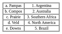
Match the following -

Detailed Solution for TS SET Paper 2 Mock Test - 7 (Geography) - Question 19

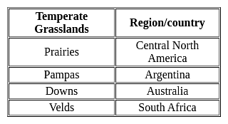
Important PointsTemperate Grasslands:

  • Temperatures vary much more in temperate grasslands than they do in savannas.
  • Savannas are in warm climates with average annual temperatures that only vary between 21 and 26 degrees Celsius (70 and 78 degrees Fahrenheit).
  • They typically have only two seasons, a wet and a dry season.
  • Temperate grasslands have hot summers where temperature can exceed 38 degrees Celsius (100 degrees Fahrenheit) and cold winters that can drop below negative 40 degrees Celsius (negative 40 degrees Fahrenheit).

Key Points


Hence, the correct matching is a - 1, b - 5, c - 4, d - 3, e - 2

TS SET Paper 2 Mock Test - 7 (Geography) - Question 20

Consider the following statements: 

A. Relict Mountain are formed by differential erosion because of differing solubility and erodibility of rocks in the region.

B. Converging boundary volcanism produces island arch like the Japanese arc

C. Alps, Andes, Appalachian and Ural are the examples of Block mountains.

D. GK Gilbert gave the Thermal Contraction Theory in 1890.

Which of the following are Incorrect? 

Detailed Solution for TS SET Paper 2 Mock Test - 7 (Geography) - Question 20

Answer: 3) Only C and D.

Key Points

  • Statement C is incorrect because Alps, Andes, Appalachian, and Ural are not examples of block mountains. They are examples of fold mountains.
  • Statement D is incorrect because G.K. Gilbert gave the Glacial rebound theory in 1890, not the Thermal Contraction Theory.
  • Thermal Contraction Theory was given by H. Jeffreys in his famous book, The Earth: Its origin history and physical constitution.

Additional Information 

Relict mountains are mountains that have been worn down by erosion over time. They are typically rounded and have gentle slopes.

Converging boundary volcanism occurs when two tectonic plates collide, causing one plate to be forced beneath the other. This process can create island arcs, which are chains of volcanic islands.

Block mountains are formed when large blocks of the Earth's crust are uplifted or tilted by tectonic forces.

Thermal Contraction Theory states that the Earth's crust has contracted as the Earth has cooled, causing mountains to form.

Glacial rebound theory states that the Earth's crust has rebounded after the weight of glaciers has been removed, causing mountains to form.

TS SET Paper 2 Mock Test - 7 (Geography) - Question 21
Biomagnification means an increase in the
Detailed Solution for TS SET Paper 2 Mock Test - 7 (Geography) - Question 21

Biomagnification means an increase in the concentration of pollutants in living organisms.

  • Biomagnification is a process by which contaminant concentrations increase in the tissue of higher species of the food chain.
  • Biomagnification, also known as bio amplification or biological magnification, is any concentration of a toxin, such as pesticides, in the tissues of tolerant organisms at successively higher levels in a food chain.
  • This increase can occur as a result of:
    • Persistence – where the substance cannot be broken down by environmental processes
    • Food chain energetics – where the substance's concentration increases progressively as it moves up a food chain
    • Low or non-existent rate of internal degradation or excretion of the substance – mainly due to water-insolubility
  • Biological magnification often refers to the process whereby certain substances such as pesticides or heavy metals work their way into lakes, rivers, and the ocean, and then move up the food chain in progressively greater concentrations as they are incorporated into the diet of aquatic organisms such as zooplankton, which in turn are eaten perhaps by fish, which then may be eaten by bigger fish, large birds, animals, or humans.
  • The substances become increasingly concentrated in tissues or internal organs as they move up the chain.
  • Bioaccumulants are substances that increase in concentration in living organisms as they take in contaminated air, water, or food because the substances are very slowly metabolized or excreted.

Thus, option 1 is the correct answer.

TS SET Paper 2 Mock Test - 7 (Geography) - Question 22
Which of the following is NOT mentioned as a challenge for the tourism industry?
Detailed Solution for TS SET Paper 2 Mock Test - 7 (Geography) - Question 22

Answer: 4) Growing preference for virtual experiences over physical travel.

The tourism industry faces numerous challenges that can impact its growth and sustainability. These challenges range from external geopolitical factors to internal shifts in consumer preferences. It's essential to identify the specific hurdles the industry must navigate to adapt effectively and continue thriving.
Key Points
Growing preference for virtual experiences over physical travel:
  • While there has been an increase in the availability and quality of virtual experiences, particularly accelerated by the COVID-19 pandemic, this trend is not commonly cited as a significant challenge to the traditional tourism industry.
  • Virtual experiences offer supplementary options for exploration and can even stimulate interest in physical travel by providing a taste of what real-world destinations have to offer.
  • They can also serve as an accessible means for those unable to travel due to financial, health, or other constraints.
  • Virtual tourism might complement rather than compete directly with physical travel experiences.
Additional Information
Competition from emerging travel destinations:
  • This is a real challenge as new and previously less-known destinations become more accessible and market themselves more effectively.
  • Competition requires established travel destinations to innovate and improve their offerings to retain and attract tourists.
  • It pushes the industry to focus on differentiation and enhancing visitor experiences to stay competitive.

Geopolitical conflicts impacting travel safety and accessibility:
  • Geopolitical conflicts and tensions can significantly impact the tourism industry by making certain destinations less safe or entirely inaccessible.
  • This challenge forces the industry to be adaptable and responsive to changing global dynamics, impacting everything from travel advisories to insurance costs and overall tourist preferences.
Increasing demand for responsible and sustainable travel practices:
  • The growing awareness and concern over environmental issues and local community impacts have led to a demand for more responsible and sustainable travel practices.
  • This challenge requires the industry to innovate and implement practices that minimize negative impacts while maximizing positive contributions to conservation efforts and local economies.
  • It signifies a shift in how travel experiences are designed, marketed, and delivered.
Important Points
  • While the tourism industry faces these and other challenges, addressing them effectively is crucial for long-term sustainability and success.
  • The ability to adapt and respond to changing consumer preferences, global situations, and calls for responsible practices will distinguish industry leaders.
  • Embracing innovation and sustainability can transform challenges into opportunities for growth and positive impact.
TS SET Paper 2 Mock Test - 7 (Geography) - Question 23
What BEST describes the impact of technology on the tourism industry?
Detailed Solution for TS SET Paper 2 Mock Test - 7 (Geography) - Question 23

Answer: 3) It offers both opportunities for personalized experiences and privacy concerns.

The profound impact of technology on the tourism industry cannot be overstated. It has revolutionized how services are delivered, enhanced the customer experience, and also introduced new challenges. Among these impacts, the ability to offer personalized travel experiences alongside emerging privacy concerns stands out as especially significant.
Key Points
It offers both opportunities for personalized experiences and privacy concerns:
  • Advanced data analytics and AI enable travel companies to tailor their offerings to individual preferences, improving customer satisfaction and engagement.
  • From personalized travel recommendations to targeted marketing, technology makes it possible to cater to the unique desires of each traveler.
  • However, this customization relies on collecting and analyzing vast amounts of personal data, raising legitimate concerns about privacy and data protection.
  • As companies navigate these opportunities, they must also address the ethical considerations and regulatory requirements associated with handling personal information.
Additional Information
INCOREECT OPTIONS:
It primarily leads to job losses in the travel industry:
  • While technology has automated certain functions that previously required manual effort, suggesting that it primarily leads to job losses oversimplifies its impact.
  • Technology also creates new opportunities and jobs within the industry, such as in digital marketing, data analysis, and IT support.
  • Furthermore, by improving efficiency and customer experiences, technology can drive growth and demand, potentially leading to job creation in other areas of the tourism sector.
It solely benefits large travel companies and booking platforms:
  • Although large travel companies and booking platforms have indeed benefited from technological advancements, they are not the sole beneficiaries.
  • Technology has also empowered smaller operators by leveling the playing field, enabling them to reach a global audience through social media, online marketplaces, and affordable travel technologies.
  • Startups and innovative enterprises can disrupt the market with new ideas and services, indicating that the benefits of technology in tourism are more widely distributed.
It has minimal impact on travel planning and booking processes:
  • This statement underestimates the dramatic transformation technology has brought to planning and booking travel.
  • Online booking platforms, mobile apps, virtual reality previews, and user-generated content on social media have all made researching and booking travel more accessible, convenient, and informative for consumers.
  • The shift towards online and mobile channels has fundamentally changed how travelers interact with the industry, making technology's impact far from minimal.
Important Points
  • The intersection of technology and tourism continues to evolve, offering immense potential to enhance the travel experience while posing new challenges.
  • As the industry adapts to these changes, the focus should remain on harnessing technology to improve services and operational efficiency, while also prioritizing ethical considerations and customer trust, particularly concerning privacy.
TS SET Paper 2 Mock Test - 7 (Geography) - Question 24
Consider the following statements:-

a) Close to the equator, tropical cyclones do not occur because of excessive humidity.

b) The largest number of temperate cyclones originate mostly over the North Atlantic Ocean.

c) The central low-pressure core of a tropical cyclone is called depression.

d) The Polar frontal theory or the wave theory provides an adequate explanation of the origin of extra tropical cyclones.

Which of the following statements are correct?

Detailed Solution for TS SET Paper 2 Mock Test - 7 (Geography) - Question 24

In the North Atlantic region high frequencies of tropical cyclones are found in the months of August, September and October. The period from December to May is free from cyclones. In the south western North Pacific greatest frequency is seen from July to October. There are no cyclones in the South Atlantic and the reason behind the absence of the tropical cyclones is that the intertropical convergence zone remains to the north of the equator so that no weak tropical disturbance develops over this ocean. Moreover, the sea surface temperature is comparatively low in the low latitudes.

TS SET Paper 2 Mock Test - 7 (Geography) - Question 25

A rise in sea level near shore due to strong winds is called

Detailed Solution for TS SET Paper 2 Mock Test - 7 (Geography) - Question 25

A storm surge is a rise in sea level that occurs during tropical cyclones, intense storms also known as typhoons or hurricanes. The storms produce strong winds that push the water into shore, which can lead to flooding.

TS SET Paper 2 Mock Test - 7 (Geography) - Question 26
The social theory that appeared as the sequel to Behaviouralism is
Detailed Solution for TS SET Paper 2 Mock Test - 7 (Geography) - Question 26

Correct Answer: Game theory.

Key Points

  • Game theory is a theory of social interaction, which attempts to explain the interaction people have with one another. As the name of the theory suggests, game theory sees human interaction as just that: a game.
  • It was initially developed to understand a large variety of economic behaviors, including the behavior of firms, markets, and consumers.
  • The use of the game theory has since expanded in the social sciences and has been applied to political, sociological, and psychological behaviors as well.
  • Game theory was first used to describe and model how human populations behave and, Game the social theory that appeared as the sequel to Behaviouralism.
  • Some scholars believe that they can predict how actual human populations will behave when confronted with situations analogous to the game being studied.

​ Additional Information

  • Behaviorism focuses on the idea that all behaviors are learned through interaction with the environment. This learning theory states that behaviors are learned from the environment, and says that innate or inherited factors have very little influence on behavior.
  • The radical approach to geography developed in the 1970s as a reaction to ‘quantitative revolution’ and positivism which tried to make geography a spatial science, with great emphasis on locational analysis. It began as a critique within the contemporary liberal capitalistic society but later coalesced around a belief in the power of Marxian analysis.
  • Structuralism is an approach within geography that is characterized by the fact that the belief that to understand the surface patterns of human behavior, it is necessary to know the structures underlying them which produce or shape human actions.
  • Feminism is a broad, complex, contested term that comprises both an intellectual and a political project that seeks to identify, understand, and dismantle inequalities between men and women.


TS SET Paper 2 Mock Test - 7 (Geography) - Question 27
Which of the following is a cause of Global warming?
Detailed Solution for TS SET Paper 2 Mock Test - 7 (Geography) - Question 27

Global warming refers to increase in average temperature of the earth. Melting of glaciers and lack of snowfall are effects of global warming. Deforestation on the other hand leads to increase in carbon dioxide and ultimately to global warming.

Thus, the correct answer is D.

TS SET Paper 2 Mock Test - 7 (Geography) - Question 28
The principle of GPS positioning is:
Detailed Solution for TS SET Paper 2 Mock Test - 7 (Geography) - Question 28

Explanation:

GPS:

  • The Global Positioning System (GPS) is a satellite-based navigation and surveying system for the determination of precise position and time, using radio signals from the satellites, in real-time or in post-processing mode.
  • GPS is being used all over the world for numerous navigational and positioning applications, including navigation on land, in the air and at sea, determining the precise coordinates of important geographical features as an essential input to mapping and Geographical Information systems (GIS), along with its use for precise cadastral surveys, vehicle guidance in cities and on highways using GPS-GIS integrated systems, earthquake and landslide monitoring, etc.

GPS Positioning:

  • GPS is a constellation of 24 or more satellites flying 20,350 km above the surface of the earth. Each one circle the planet twice a day in one of six orbits to provide continuous, worldwide coverage.
  • The absolute coordinates of the antenna position (centered over the survey station) are determined using a single GPS receiver, by a method similar to the resection method used in plane tabling.

How GPS Works:

  1. GPS satellites broadcast radio signals providing their locations, status, and precise time (t1) from onboard atomic clocks.
  2. The GPS radio signals travel through space at the speed of light (c), more than 299,792 km/second.
  3. GPS device receives the radio signals, noting their exact time of arrival (t2), and uses these to calculate its distance from each satellite in view.
  4. Once a GPS device knows its distance from at least four satellites, it can use geometry to determine its location on Earth in three dimensions
TS SET Paper 2 Mock Test - 7 (Geography) - Question 29

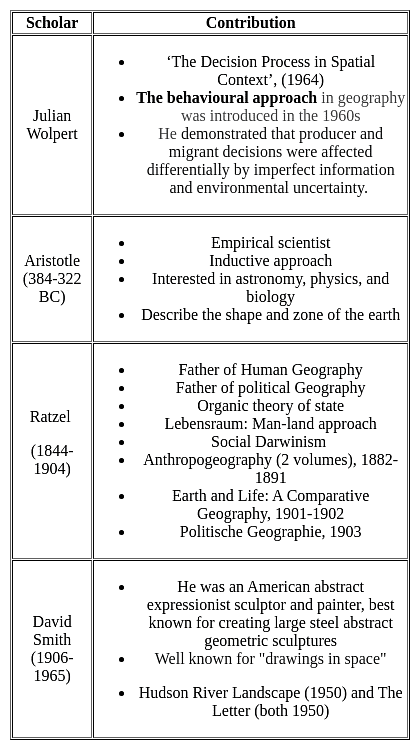
Which one of the following pairs is NOT matched correctly?

Detailed Solution for TS SET Paper 2 Mock Test - 7 (Geography) - Question 29

David Smith : Marxist perspective is NOT matched correctly
Important Point

TS SET Paper 2 Mock Test - 7 (Geography) - Question 30

It is essential to pay more regard to which of the following two things while classifying maps into different categories?

Detailed Solution for TS SET Paper 2 Mock Test - 7 (Geography) - Question 30

Scales are required to navigate maps correctly. It gives you an accurate understanding of distance. For example if the scale on a map states: 1:100000 or is 1:100000 scale map. Then that would mean that 1cm on the map would equal 1 km scale on the ground.

View more questions
60 tests
Information about TS SET Paper 2 Mock Test - 7 (Geography) Page
In this test you can find the Exam questions for TS SET Paper 2 Mock Test - 7 (Geography) solved & explained in the simplest way possible. Besides giving Questions and answers for TS SET Paper 2 Mock Test - 7 (Geography), EduRev gives you an ample number of Online tests for practice

Top Courses for TS TET

Download as PDF

Top Courses for TS TET