TS TET Exam  >  TS TET Tests  >  TS SET Mock Test Series 2024  >  TS SET Paper 2 Mock Test - 6 (Geography) - TS TET MCQ

TS SET Paper 2 Mock Test - 6 (Geography) - TS TET MCQ


Test Description

30 Questions MCQ Test TS SET Mock Test Series 2024 - TS SET Paper 2 Mock Test - 6 (Geography)

TS SET Paper 2 Mock Test - 6 (Geography) for TS TET 2025 is part of TS SET Mock Test Series 2024 preparation. The TS SET Paper 2 Mock Test - 6 (Geography) questions and answers have been prepared according to the TS TET exam syllabus.The TS SET Paper 2 Mock Test - 6 (Geography) MCQs are made for TS TET 2025 Exam. Find important definitions, questions, notes, meanings, examples, exercises, MCQs and online tests for TS SET Paper 2 Mock Test - 6 (Geography) below.
Solutions of TS SET Paper 2 Mock Test - 6 (Geography) questions in English are available as part of our TS SET Mock Test Series 2024 for TS TET & TS SET Paper 2 Mock Test - 6 (Geography) solutions in Hindi for TS SET Mock Test Series 2024 course. Download more important topics, notes, lectures and mock test series for TS TET Exam by signing up for free. Attempt TS SET Paper 2 Mock Test - 6 (Geography) | 100 questions in 120 minutes | Mock test for TS TET preparation | Free important questions MCQ to study TS SET Mock Test Series 2024 for TS TET Exam | Download free PDF with solutions
TS SET Paper 2 Mock Test - 6 (Geography) - Question 1

Which of the following periods is referred to as a period of stagnant or stationary phase of growth of India’s population?

Detailed Solution for TS SET Paper 2 Mock Test - 6 (Geography) - Question 1

The correct answer is 1901 - 1921.

Key Points

  • Period of stagnant:-
    • The period referred to as a "stagnant or stationary phase of growth" of India's population is a demographic concept known as the "demographic transition."
    • This refers to the transition from a high birth rate and high death rate society to a low birth rate and low death rate society, typically accompanied by an intermediate phase of rapid population growth.
    • During the early stages of demographic transition, a country experiences high birth rates due to factors such as lack of family planning, high infant mortality rates (leading to a need for larger families), and traditional cultural norms.
    • 1901 - 1921 is referred to as a period of stagnant or stationary phase of growth of India’s population.

Additional Information

  • Census 2011:-
    • It was the 15th Census of India and the 7th Census of Independent India.
    • Census 2011 Commissioner: C. Chandramouli
    • Slogan: Our Census, Our Future
    • No. of districts: 640
    • No. of towns: 7933
    • No.of villages: 640930
    • The total population of India as per the Census 2011 is 1210.19 million of which 623.7 million were males and 586.46 million were females.
    • Sex Ratio: 943 Females/1000
    • Child Sex Ratio: 919( Rural- 923, Urban- 905)
    • The density of Population: 382 Person/Km2
    • Literacy Rate: 74.04% of the total population( males: 82.14% and females: 65.46%)
    • Population Growth Rate during the decade: 17.7%
TS SET Paper 2 Mock Test - 6 (Geography) - Question 2

Which of the following model is an example of spatial interaction?

Detailed Solution for TS SET Paper 2 Mock Test - 6 (Geography) - Question 2

Spatial interaction models aim to explain the flow of people, resources or ideas from one geographical space to another. The gravity model is a type of models based on Sir Isaac Newton’s low of gravitation. It can show trade, migration, between two cities. The gravity model is thus an example of spatial interaction.

TS SET Paper 2 Mock Test - 6 (Geography) - Question 3

Given below are two statements, one is labelled as Assertion (A) and the other is labelled as Reason (R). Read the statements and choose the correct answer using the code given below.

Assertion (A) : Central Business District (CBD) of a city has high concentration of wholesale stores, offices and cultural and recreational activities.

Reason (R) : Prices and demand of real increases as distance towards CBD reduces.

Detailed Solution for TS SET Paper 2 Mock Test - 6 (Geography) - Question 3
Key Points

Assertion (A): Central Business District (CBD) of a city has a high concentration of wholesale stores, offices, and cultural and recreational activities.

The concept of CBD:

  • The term Central Business District (CBD) is a widely used term in commercial real estate and is defined as the functional area of a city that has the maximum concentration of commercial, retail, and business centers.
  • Geographically, it coincides with the city center and is the focal point for the transportation networks of the city.
  • It has maximum urban density than other districts of the town and offers a healthy environment for carrying out various commercial activities.
  • Today, CBDs are a diverse region in metro cities that not only include retail spaces, commercial, offices, financial institutions, government centres, and medical centres, but also entertainment hubs, restaurants, hotels, and residential area

Hence, the assertion is correct.

Reason (R): Prices and demand of real increases as distance towards CBD reduces.

Price and demand relationship:

  • In ancient times, CBDs were the market squares where merchants and customers gathered to sell and buy things.
  • However, as cities evolved, land scarcity and increasing demand reduced horizontal expansions and gave way to vertical developments.
  • The relationship of land price and distance to CBD is significant and negative, which means indicating the decreasing of land price by increasing distance from the CBD.
  • Market price gives the same result as the appraised price which is the effect of distance on land values is significant and negative.

Hence, the reason is also correct.

Therefore, Both (A) and (R) are true and (R) is the correct explanation of (A).

TS SET Paper 2 Mock Test - 6 (Geography) - Question 4
The point above which the satellite or any celestial body lies is known as _____________
Detailed Solution for TS SET Paper 2 Mock Test - 6 (Geography) - Question 4

Nadir:

It is the point on the lower portion of the celestial sphere marked by a plumb line, below the observer. It is the point above which the satellite or any celestial body lies.

Zenith:

It is the point on the upper portion of the celestial sphere marked by a plumb line, above the observer. It is the point that is present above the celestial body.

Important Astronomical Terms:

Azimuth:

The azimuth of a heavenly body is the angle between the observer’s meridian and the vertical circle passing through the heavenly body.

Celestial Horizon:

A plane tangential to Earth's surface at the observer's location cuts the celestial sphere at the celestial horizon. it cuts the universe into two for the observer.

Declination Circle:

It is a great circle passing through the center of the celestial sphere and the celestial poles.

Declination Angle:

It is the angle measured from the celestial equator, along the declination circle passing through the star under consideration.

Co Declination:

It is the distance of the star from the celestial pole and it is also known as polar distance.

Altitude:

It is the angle measured from the celestial horizon through the vertical circle passing through the star.

Co Altitude:

It is the angular distance of a star measured from Zenith along the vertical circle through the star, it is also known as zenith distance.

Hour Angle:

The angle was measured between the observer's meridian and the declination circle through the star.

TS SET Paper 2 Mock Test - 6 (Geography) - Question 5
As per the census of 2011, what is the annual growth rate in population of India from 2001 to 2011?
Detailed Solution for TS SET Paper 2 Mock Test - 6 (Geography) - Question 5
The correct answer is 1.64 percent.Key PointsThe annual population growth rate of India according to Census 2011 is 1.64 percent.Growth of population is the change in the number of people living in a particular area between two points of time. Its rate is expressed in percentage. The Census was first started under British Viceroy Lord Mayo in 1872. It helped in framing new policies, government programs to uplift areas of improvement in the community.First synchronized census in India took place in 1881. Since 1901, it has been taking place after every decade.Census 2011 is the 15th Census, and 7th after Independence.The slogan of census 2011 is “Our Census, Our Future”.According to the Census 2011, there are 53 (million-plus) cities in India as compared to 35 on census 2001.The 15th Census of India was conducted in 2011.Additional InformationKEY POINT OF CENSUS OF INDIA 2011 Total Population of India – 1,21,08,54,977Sex Ratio (females per 1000 males) – 943Density – 382 persons per sq. kmInfant Mortality Rate (2006) – 57 per 1000 live birthsMaternal Mortality Rate – 407 per lakh live birthsLiteracy Rate of the country – 74.04%Highest literacy – Kerala (94%)Lowest literacy – Bihar ( 61.8%)Highest female literacy – Kerala (92.1 %)Lowest female literacy – Rajasthan (57.6%)Highest Population – Uttar Pradesh (19,98,12,341)Lowest Population – Sikkim ( 6,10,577)Highest Population Density – Bihar (1106)Lowest Population Density – Arunachal Pradesh (17)Highest Sex Ratio – Kerala (1084)State having lowest Sex Ratio – Haryana (879)Life Expectancy at Birth – 66.1 years, Male – 64.6 years and Female – 67.7 years.Decadal growth rate in Population – 17.7%Highest SC population is in UP.Highest ST population is in Madhya Pradesh.
TS SET Paper 2 Mock Test - 6 (Geography) - Question 6
Which of the following option is correct in the case of fronts and frontogenesis?
Detailed Solution for TS SET Paper 2 Mock Test - 6 (Geography) - Question 6

The term Frontogenesis was first used by Tor Bergeron for the creation of new fronts. Later, it was extended to include the process of regeneration of old and decaying fronts. The term is a Latin derived term. Frontogenesis occurs when the wind blows in such a way that the isotherms become packed along the leading edge of the intruding air mass.

Generally, the isobars in an air mass are smooth curves and there are no sharp bends in them. And frontal activity is always associated with cloudiness and precipitation. Since warm air moves up along the frontal surface, it cools adiabatically and thus results in cloudy condensation and precipitation.

The appearance of warm front is mostly observed by the presence of cirrus clouds.

TS SET Paper 2 Mock Test - 6 (Geography) - Question 7
Sir Isaac Newton has improvised on the work of
Detailed Solution for TS SET Paper 2 Mock Test - 6 (Geography) - Question 7

Varenius is famous for his book Geographica Generalis. It is divided into three sections of absolute geography, comparative geography and relative geography. It is head as an important addition to the knowledge about comparative and scientific geography. Sir Isaac Newton made a lot of improvisation on the 1672 Cambridge edition of this book.

TS SET Paper 2 Mock Test - 6 (Geography) - Question 8

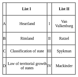
Match List I with List II:

Choose the correct answer from the options given below:

Detailed Solution for TS SET Paper 2 Mock Test - 6 (Geography) - Question 8

Therefore the correct option is A-IV, B - III, C- I, D - II

TS SET Paper 2 Mock Test - 6 (Geography) - Question 9
Which period in demographic history of India is known as the 'demographic divide'?
Detailed Solution for TS SET Paper 2 Mock Test - 6 (Geography) - Question 9

The period of stagnant population or the year of 1921 is referred to as the demographic divide. During most of the 19th century India witnessed a slow growth of population which continued till the year 1921. The population was more or less stagnant, and the high birth rate was counterbalanced by high death rate. Large scale abnormal deaths were present in this period. The census year of 1921 witnessed only a negative growth rate of -0.31% which was observed only once in India.

TS SET Paper 2 Mock Test - 6 (Geography) - Question 10
In India, rigid and stable elevated lands, denuded rocks and series of scarps are the features of which of the following?
Detailed Solution for TS SET Paper 2 Mock Test - 6 (Geography) - Question 10

The correct answer is the Peninsular plateau.

Key Points

  • Peninsular plateau
    • The land of India is characterized by great diversity in its physical features.
    • The north has a vast expanse of rugged topography consisting of a series of mountain ranges with varied peaks, beautiful valleys, and deep gorges.
    • The south consists of stable tableland with highly dissected plateaus, denuded rocks, and developed series of scarps. In between these two lies the vast north Indian plain. Hence, Option 2 is correct.
    • The Peninsular plateau is a tableland made up of crystalline, igneous, and metamorphic rocks. It was produced by the breakup and drifting of the Gondwana continent, making it the oldest landmass on the planet. Tors, block mountains, rift valleys, spurs, bare rocky formations, series of hummocky hills, and wall-like quartzite dykes are some of the region's key physiographic characteristics, which provide natural water storage sites.
    • It was developed as a result of the breakup and drifting of the Gondwana continent, making it one of the oldest landmasses.
    • The plateau has large and shallow valleys as well as rounded hills.
    • This plateau is divided into two sections: the Central Highlands and the Deccan Plateau.
    • The Central Highlands are the parts of the Peninsular plateau to the north of the Narmada river that cover a large portion of the Malwa plateau.
    • The general height of the plateau is from west to east, as seen by the direction of river flow.
    • This Peninsular plateau has seen recurring periods of uplift and submergence, which have been accompanied by crustal faulting and fractures.
    • The relief of the Peninsular plateau has become more diverse as a result of these spatial variations.

Additional Information

  • Northern mountains
    • The northern mountain complex contains the Himalayas, Trans Himalayas and Purvachal.
    • The Himalayas are in the north, Hindukush and Sulaiman are in the northwest and Purvachal in the east.
    • The Himalayas are true mountains. They are formed from the continent-continent plate collision. They have sediments of marine origin. It is not a single range but a series of ranges.
    • The Himalayas have three ranges namely the great Himalayas [Himadri], middle or lesser Himalayas [Himachal] and outer Himalayas [Shiwaliks].
  • Northern Plain
    • Youngest physiographic feature in India. Depositional flood plain created by Himalayan rivers like Indus, Ganga, Brahmaputra and Yamuna.
    • Densely populated with 30% of the world's population on 10% of the world's agricultural land.
  • Coastal plains
    • It extends from Rann of Kutch to Sunderbans.
    • It has two parts western coastal plain and the eastern coastal plain.
TS SET Paper 2 Mock Test - 6 (Geography) - Question 11

____________ predominantly acts as the agent of chemical erosion of soil.

Detailed Solution for TS SET Paper 2 Mock Test - 6 (Geography) - Question 11

Underground water predominantly acts as the agent of chemical erosion of soil.

TS SET Paper 2 Mock Test - 6 (Geography) - Question 12
In the UN’s sustainable development goals are intended to be achieved by the year
Detailed Solution for TS SET Paper 2 Mock Test - 6 (Geography) - Question 12

 The sustainable development goals are set of 17 goals designed to achieve the measure and problems of society and the way to sustainable deal with the same. This was set in 2015 by the United Nation general assembly and intended to be achieved by the year 2030.

Thus, the Correct answer is D .

TS SET Paper 2 Mock Test - 6 (Geography) - Question 13

Which of the following is NOT a use of total station?

Detailed Solution for TS SET Paper 2 Mock Test - 6 (Geography) - Question 13

Total station:

  • A total station (TS) or total station theodolite (TST) is an electronic/optical instrument used for surveying and building construction.
  • It is an electronic transit theodolite integrated with electronic distance measurement (EDM) to measure the sloping distance of the object to the instrument, horizontal angles, and vertical angles.
  • This Microprocessor unit enables for computation of data collected to further calculate the horizontal distance, coordinates of a point, and reduced level of the point.
  • Data collected from the total stations can be downloaded into computers/laptops for further processing of information.
  • Total stations are mainly used by land surveyors and civil engineers, either to record features as in topographic surveying or to set out features (such as roads, houses, or boundaries).
  • They are also used by archaeologists to record excavations and by police, crime scene investigators, private accident deconstructionists, and insurance companies to take measurements of scenes. 

TS SET Paper 2 Mock Test - 6 (Geography) - Question 14

Consider the following statements regarding the transport sector:

1. The value of the material is significantly enhanced by transportation.

2. In selecting the mode of transport, distance, in terms of time or cost, is the determining factor.

3. Isochrone lines are drawn on a map to join places equal in terms of the time taken to reach them.

Which of the above statements is/are not correct?
Detailed Solution for TS SET Paper 2 Mock Test - 6 (Geography) - Question 14

Transport

  • Transport is a service or facility by which people, materials and manufactured goods are physically carried from one location to another.
  • It is an organised industry created to satisfy man’s basic need of mobility.
  • Modern society requires speedy and efficient transport systems to assist in the production, distribution and consumption of goods.
  • At every stage in this complex system, the value of the material is significantly enhanced by transportation.
  • Transport distance can be measured as:
    • km distance or actual distance of route length
    • time distance or the time taken to travel on a particular route and
    • cost distance or the expense of travelling on a route.
  • In selecting the mode of transport, distance, in terms of time or cost, is the determining factor.
  • Isochrone lines are drawn on a map to join places equal in terms of the time taken to reach them.
TS SET Paper 2 Mock Test - 6 (Geography) - Question 15
How are resources divided on the basis of status of development? 
Detailed Solution for TS SET Paper 2 Mock Test - 6 (Geography) - Question 15

The correct answer is Potential, developed, stock, and reserves.

Key Points

  • Resource refers to all the materials available in our environment that help us to satisfy our needs and wants.
  • Resources are classified on the basis of their status of development which includes potential, developed stock, and reserves.
  • Resources can be classified in the following ways–
    • On the basis of origin – biotic and abiotic
    • On the basis of exhaustibility – renewable and non-renewable
    • On the basis of ownership – individual, community, national and international
    • On the basis of the status of development – potential, developed, stock, and reserves.

Additional Information

  •  On the basis of the status of development, resources are classified into four groups, namely potential, developed, stock, and reserve.
    • Potential Resources: Potential resources are those which are found in a region, but have not been utilized. For example, solar energy and wind energy, available in Rajasthan and Gujarat, have not been developed properly.
    • Developed Resources: Developed resources are those that are estimated in terms of their quantity and quality for utilization, e.g., water, soil, and forests.
    • Stock Resources: Materials in the environment that have the potential to satisfy human needs but are not technologically accessible to human beings, e.g., the use of water as a rich source of energy.
    • Reserve Resources: A Reserve is a part of the stock that can be put to use in the near future with the help of existing technology, e.g., water in dams, and forests.
TS SET Paper 2 Mock Test - 6 (Geography) - Question 16
Which of these is not a type of federal state ?
Detailed Solution for TS SET Paper 2 Mock Test - 6 (Geography) - Question 16

Key Points

Federal state:

  • The federal government is a type of national government in which the government has powers to delegates the power to other elected members of the states.
  • There can be two levels of the federal government in a country either it is performing through common institutions or through powers as prescribed by a constitution of the state.
  • It is totally opposite to the unitary government.
  • In federation or federal government, provinces or territories enjoy some rights as are available to the independent states.
  • However international diplomacy, national security, foreign affairs, and other kinds of international dealings are solely made by the federal government.
  • In the federal system, power is jointly shared between the state and federal governments.
  • In the federal government system, the powers never rest with one national government.
  • However, there can be certain powers and authorities that remain totally with the federal government like policies on defence, budget, international diplomacy, etc.
  • Some of the examples are India, Pakistan, India, Brazil, Switzerland, Australia, Belgium, Canada, etc.
  • The three lists and their components are as follows,

  • It has a centralized form along with state and common responsibilities,

Therefore, Composite is not a type of federal state.

TS SET Paper 2 Mock Test - 6 (Geography) - Question 17

Brahmaputra River when it flows out of India into Bangladesh is called as ________?

Detailed Solution for TS SET Paper 2 Mock Test - 6 (Geography) - Question 17

Brahmaputra River when it flows out of India into Bangladesh is called as Jamuna River.

TS SET Paper 2 Mock Test - 6 (Geography) - Question 18

What is the significance of understanding landscape evolution according to the passage?

Detailed Solution for TS SET Paper 2 Mock Test - 6 (Geography) - Question 18

Answer: Option 1) Predicting future geological hazards.

Understanding landscape evolution is crucial for various reasons, encompassing geological hazards, ecological dynamics, and human interactions with the environment.

Key Points

  • Predicting future geological hazards: By understanding how landscapes evolve over time, scientists can better predict and mitigate geological hazards such as landslides, earthquakes, and volcanic eruptions.
  • This knowledge enables proactive measures to protect lives and property. 

Additional Information 

Enhancing agricultural practices: Knowledge of landscape evolution informs agricultural practices by identifying suitable landforms for cultivation, understanding soil formation processes, and managing erosion risks. This insight contributes to sustainable agricultural development and food security.

Exploring extraterrestrial landscapes: Understanding landscape evolution on Earth provides valuable insights for interpreting landforms on other planets and celestial bodies. Comparative geomorphology helps scientists unravel the geological history of extraterrestrial landscapes and assess their potential for supporting life.

Understanding human psychology: Landscapes play a significant role in shaping human perceptions, emotions, and behavior. Understanding how landscapes evolve over time can deepen our understanding of human psychology, cultural perceptions of the environment, and the connections between people and place.

Hence,  understanding landscape evolution has multifaceted significance, ranging from mitigating geological hazards and enhancing agricultural practices to exploring extraterrestrial landscapes and understanding human psychology. This knowledge underscores the interdisciplinary nature of geomorphology and its relevance to diverse fields and societal challenges.

TS SET Paper 2 Mock Test - 6 (Geography) - Question 19

What criticism has the cycle of erosion theory faced?

Detailed Solution for TS SET Paper 2 Mock Test - 6 (Geography) - Question 19

Answer: Option 1) Oversimplified view of landscape development.

The cycle of erosion theory, while influential in geomorphology, has faced criticism for various aspects of its conceptual framework.

Key Points

  • Oversimplified view of landscape development: One criticism of the cycle of erosion theory is its tendency to oversimplify landscape development.
  • Critics argue that the theory does not adequately account for the complexity of geological processes and the multitude of factors influencing landscape evolution beyond the basic cycle outlined by Davis.
  • The cycle of erosion theory has faced criticism for its oversimplified view of landscape development, potential overemphasis on climate variability, failure to account for volcanic activity, and limited inclusion of biological factors.
  • Addressing these critiques can lead to a more comprehensive understanding of landscape evolution and its underlying processes. 

Additional Information 

  • Overemphasis on climate variability: While climate variability is indeed a significant factor in landscape evolution, critics argue that the cycle of erosion theory may place too much emphasis on climatic factors at the expense of other geological and tectonic processes. This overemphasis can lead to an incomplete understanding of landscape dynamics.
  • Failure to Account for volcanic activity: Another criticism of the cycle of erosion theory is its limited consideration of volcanic activity in landscape evolution. Volcanic processes, such as lava flows and volcanic eruptions, can have profound effects on landforms and may not be adequately addressed within the framework of the cycle of erosion.
  • Inclusion of biological factors in landscape evolution: While biological factors, such as vegetation cover and the activity of organisms, can influence landscape evolution, some critics argue that the cycle of erosion theory may not adequately incorporate these factors into its conceptual framework. This omission can limit the theory's explanatory power in certain contexts.

In response to these critiques, subsequent geomorphologists have refined and expanded upon Davis's original model. Concepts such as dynamic equilibrium, threshold theory, and the influence of climate variability have enriched our understanding of landscape evolution, challenging the notion of a uniform cycle of erosion.

TS SET Paper 2 Mock Test - 6 (Geography) - Question 20

In which stage of landscape evolution do relief features become more subdued?

Detailed Solution for TS SET Paper 2 Mock Test - 6 (Geography) - Question 20

Answer: Option 2) Mature stage.

Key Points

  • Understanding the stages of landscape evolution is essential for comprehending how landforms change over time.
  • One critical aspect of this evolution is the transformation of relief features, which become more subdued as landscapes progress through various stages.
  • Mature stage: The mature stage represents a transitional phase where relief features begin to become more subdued.
  • While some rugged terrain may still persist, the overall topography becomes gentler, with smoother slopes and less pronounced landforms.
  • Rivers widen their valleys through lateral erosion, and the landscape achieves a more balanced state between erosion and uplift.

Additional Information 

  • Youthful stage: In the youthful stage of landscape evolution, relief features are typically pronounced, characterized by steep slopes, rugged terrain, and prominent landforms such as peaks and valleys. This stage is marked by intense erosion and rapid changes in topography as geological forces sculpt the landscape with vigor.
  • Old age stage: In the old age stage, relief features are significantly subdued, and the landscape exhibits low relief with nearly level surfaces. Rivers meander across broad floodplains, and mountain ranges are reduced to residual hills and isolated remnants. This stage is characterized by extensive erosion, leading to the formation of peneplains—nearly level surfaces eroded to a uniform low elevation.
  • Transitional stage: The transitional stage represents a period of flux between different stages of landscape evolution. Relief features may exhibit characteristics of both youthful and mature stages as the landscape undergoes gradual transformation. This stage is marked by dynamic processes as the landscape adjusts to changing geological and environmental conditions.

Important Points 

  • The transformation of relief features is influenced by a variety of factors, including the type and intensity of erosion, tectonic activity, and climatic conditions.
  • Different landscapes may exhibit variations in the rate and sequence of relief feature modification, depending on their geological history and environmental context.
TS SET Paper 2 Mock Test - 6 (Geography) - Question 21

What is the primary driving force behind the cycle of erosion theory?

Detailed Solution for TS SET Paper 2 Mock Test - 6 (Geography) - Question 21

Answer: Option 2) Weathering and erosion.

Key Points

  • The primary driving force behind the cycle of erosion theory is crucial to understanding the dynamic processes shaping the Earth's surface.
  • This theory, proposed by William Morris Davis, elucidates the intricate interplay of geological forces that mold landscapes over geological time scales.
  • Weathering and erosion: This option accurately reflects the primary driving force behind the cycle of erosion theory.
  • Weathering refers to the breakdown of rock into smaller particles, while erosion involves the removal and transportation of these particles.
  • Together, weathering and erosion shape the Earth's surface over time, sculpting landscapes into various forms.

Important Points

  •  Weathering can be categorized into mechanical (physical) weathering and chemical weathering.
  • Mechanical weathering involves physical processes like freeze-thaw cycles and abrasion, while chemical weathering involves chemical reactions that alter the mineral composition of rocks.
  • Erosion is predominantly carried out by agents such as water, wind, ice (glaciers), and gravity.
  • These agents sculpt landscapes by transporting weathered material from one location to another, leading to the formation of various landforms such as valleys, canyons, and deltas.

Additional Information 

Tectonic subsidence: While tectonic movements play a significant role in landscape evolution by causing uplift and subsidence, tectonic subsidence alone does not encompass the entire process described by the cycle of erosion theory. It contributes to changes in elevation but is not the sole driving force behind erosion and landscape development.

Climate variability: Climate variability influences erosion rates and patterns by affecting factors such as precipitation, temperature, and vegetation cover. However, while climate variability is a significant factor in landscape evolution, it is not the primary driving force described by the cycle of erosion theory.

Glacial deposition: Glacial deposition, a process where glaciers deposit sediments as they advance and retreat, is a component of landscape evolution, particularly in regions influenced by glaciation. However, it is a specific aspect of erosion and deposition rather than the overarching driving force behind the cycle of erosion theory.

TS SET Paper 2 Mock Test - 6 (Geography) - Question 22
Which union territory has the lowest population in India as per the census of 2011
Detailed Solution for TS SET Paper 2 Mock Test - 6 (Geography) - Question 22

 The Union territory of Lakshadweep has total population of 64,473, which accounts for 0.01% of the total population of India according to census of 2011. The population density here is 382 persons per square km.

Thus, the correct answer is B.

TS SET Paper 2 Mock Test - 6 (Geography) - Question 23

Sub tropical high-pressure belt is called ………………

Detailed Solution for TS SET Paper 2 Mock Test - 6 (Geography) - Question 23

The horse latitudes are subtropical regions known for calm winds and little precipitation. The horse latitudes are regions located at about 30 degrees north and south of the equator. These latitudes are characterized by calm winds and little precipitation.

TS SET Paper 2 Mock Test - 6 (Geography) - Question 24
Cape Agulhas makes the dividing point between which of the two oceans?
Detailed Solution for TS SET Paper 2 Mock Test - 6 (Geography) - Question 24

The correct answer is The Atlantic Ocean and the Indian Ocean. Key Points

  • Cape Agulhas is a rocky headland in Western Cape, South Africa. It is the geographic southern tip of the African continent
  • It is the beginning of the dividing line between the Atlantic and Indian Oceans according to the International Hydrographic Organization.
  • This is the place where the warm-water Agulhas current of the Indian Ocean meets the cold-water Benguela current of the Atlantic Ocean and turns back on itself.

Additional Information

  • The Pacific Ocean is the largest and deepest of Earth's five oceanic divisions. It extends from the Arctic Ocean in the north to the Southern Ocean in the south and is bounded by the continents of Asia and Oceania in the west and the Americas in the east.
  • The Atlantic Ocean is the second-largest of the world's five oceans, with an area of about 106,460,000 km². It covers approximately 20% of Earth's surface and about 29% of its water surface area.
  • The Indian Ocean is the third-largest of the world's five oceanic divisions. The shape of ocean is almost triangular. In the north, it is bound by Asia, in the west by Africa and in the east by Australia.
  • The Arctic Ocean is the smallest and shallowest of the world's five major oceans. It spans an area of approximately 14,060,000 km² and is known as the coldest of all oceans. 

Thus, Cape Agulhas makes the dividing point between The Atlantic Ocean and the Indian Ocean.

TS SET Paper 2 Mock Test - 6 (Geography) - Question 25

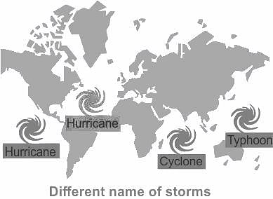
A cyclone is known by different names in different parts of the world. In Philippines it is called as _______.

Detailed Solution for TS SET Paper 2 Mock Test - 6 (Geography) - Question 25

The correct answer is a typhoon.

Key Points

  • A cyclone is known by different names in different parts of the world.
  • It is called a 'typhoon’ in Japan and the Philippines.
  • While they are called ‘cyclones’ in the Indian and South Pacific oceans.
  • In the Atlantic Ocean, they are called ‘hurricanes’.

Additional Information

  • Cyclone:
    • A cyclone is a large air mass that rotates around a strong centre of low atmospheric pressure.
    • Cyclones rotate clockwise in the Southern Hemisphere and anti-clockwise in the Northern Hemisphere.
    • Cyclones are rapid inward air circulation around a low-pressure area.
    • Factors like wind speed, wind direction, temperature and humidity contribute to the development of cyclones.
    • Cyclone/Strom is termed by different names in different continents -

Important Points

  • Cyclone is a chain of events that ends with the formation of a very low-pressure system with very high-speed winds revolving around it.
  • The centre of a cyclone is a calm area.
  • It is called the eye of the storm.
  • A large cyclone is a violently rotating mass of air in the atmosphere, 10 to 15 km high.
  • A cyclone is known by different names in different parts of the world.
  • It is called a ‘hurricane’ on the American continent.
  • In the Philippines and Japan, it is called a ‘typhoon’.
  • In Australia it is known as willy - willy.

TS SET Paper 2 Mock Test - 6 (Geography) - Question 26

Read the following statements about sustainable development.

Statement (A): Sustainable development is a process of maximum exploitation of resources.

Statement (B): In absence of sustainable development non-renewable resources can definitely get exhauste.

Choose the correct option.

Detailed Solution for TS SET Paper 2 Mock Test - 6 (Geography) - Question 26

The correct option is: (A) is false, but (B) is true.
Important Points

Statement (A) states that sustainable development is a process of maximum exploitation of resources.

  • This statement is false.
  • Sustainable development aims to balance economic, social, and environmental considerations to meet the needs of the present generation without compromising the ability of future generations to meet their own needs.
  • It emphasizes the responsible and efficient use of resources rather than maximum exploitation.

Statement (B) states that in the absence of sustainable development, non-renewable resources can definitely get exhausted.

  • This statement is true.
  • Non-renewable resources such as fossil fuels (coal, oil, natural gas) and minerals are finite in quantity and take millions of years to form.
  • If these resources are not managed sustainably, they can be depleted faster than they can be replenished, leading to their exhaustion.

Therefore, (A) is false as sustainable development does not involve maximum exploitation of resources, and (B) is true as non-renewable resources can indeed get exhausted in the absence of sustainable development.

TS SET Paper 2 Mock Test - 6 (Geography) - Question 27
Which one of the following kinds of towns was not planned and developed during the British Rule in India?
Detailed Solution for TS SET Paper 2 Mock Test - 6 (Geography) - Question 27

Cantonment Towns

  • The nature of the colonial city changed further in the mid-nineteenth century. After the Revolt of 1857 British attitudes in India were shaped by a constant fear of rebellion. They felt that towns needed to be better defended, and white people had to live in more secure and segregated enclaves, away from the threat of the “natives ”.
  • Pasturelands and agricultural fields around the older towns were cleared, and new urban spaces called “Civil Lines” were set up. White people began to live in the Civil Lines.
  • Cantonments– places where Indian troops under European command were stationed – were also developed as safe enclaves. These areas were separate from but attached to the Indian towns. With broad streets, bungalows set amidst large gardens, barracks, parade ground and church, they were meant as a safe haven for Europeans as well as a model of ordered urban life in contrast to the densely built up Indian towns.

Railway Colonies

  • The introduction of railways in 1853 meant a change in the fortunes of towns. Economic activity gradually shifted away from traditional towns which were located along old routes and rivers. Every railway station became a collection depot for raw materials and a distribution point for imported goods.
  • With the expansion of the railway network, railway workshops and railway colonies were established. Railway towns like Jamalpur, Waltair and Bareilly developed.

Hill Stations

  • As in the case of cantonments, hill stations were a distinctive feature of colonial urban development. The founding and settling of hill stations was initially connected with the needs of the British army.
  • Simla (present-day Shimla) was founded during the course of the Gurkha War (1815-16); the Anglo-Maratha War of 1818 led to British interest in Mount Abu; and Darjeeling was wrested from the rulers of Sikkim in 1835.
  • Hill stations became strategic places for billeting troops, guarding frontiers and launching campaigns against enemy rulers.
TS SET Paper 2 Mock Test - 6 (Geography) - Question 28
The system designed to capture, store, manipulate, analyze, manage and present spatial or geographical data can be termed as
Detailed Solution for TS SET Paper 2 Mock Test - 6 (Geography) - Question 28

Concept:

GIS stands for the geographic information system. These are programs or a combination of programs that work together to help users make sense of their spatial data. This includes management, manipulation and customization, analysis, and creating visual displays.

Spatial data, also known as geospatial data, is a term used to describe any data related to or containing information about a specific location on the Earth’s surface. It exists in a variety of formats and contains more than just location-specific information.

G.I.S has following components

1. Hard ware (computer)

2. Software

3. Data management

4. End User and

5. Methods

The global positioning system (GPS) is a space based satellite navigation system that provides location and time information in all weather, anywhere or near the earth. It is maintained by the United States Government and is freely accessible to anyone. The GPS program critical capabilities to military, civil and commercial users around the world. In addition, GPS is the backbone for modernizing the global air traffic system.

TS SET Paper 2 Mock Test - 6 (Geography) - Question 29

Identify the option that arranges the following states' literacy rates in descending order, according to Census 2011.

A. Kerala

B. Himachal Pradesh

C. Haryana

Detailed Solution for TS SET Paper 2 Mock Test - 6 (Geography) - Question 29
The correct answer is (A), (B), (C).
Key Points
  • According to Census 2011, the literacy rates of the states in descending order are Kerala, Himachal Pradesh, and Haryana.
  • Kerala has the highest literacy rate of 94% among all the states in India.
  • Haryana has a literacy rate of 75.6%.
  • Himachal Pradesh has a literacy rate of 82.80%.

Additional Information

  • The Indian Census is the largest single source of a variety of statistical information on different characteristics of the people of India.
  • The first census of India was conducted by Lord Mayo in 1872.
  • The first official census was started by Lord Ripon in 1881.
  • In 2011 it is 15 census of India.
  • It comes to the Ministry of Home Affairs From 1961.
  • The slogan of the 2011 Census is Our Census Our Future.
  • C M Chandramauli was the Registrar General and Census Commissioner of India for the 2011 Indian Census.
TS SET Paper 2 Mock Test - 6 (Geography) - Question 30

Compared with North American cities, western European cities are generally more compact, with lower skylines, narrower streets, and more irregular street patterns. This difference is primarily a reflection of the:

Detailed Solution for TS SET Paper 2 Mock Test - 6 (Geography) - Question 30

This question requires the examinee to demonstrate knowledge of the purposes, organization, and functions of diverse human settlements; processes influencing the establishment of human settlements; and the ways in which settlements change over time. The compact form, low skylines, narrow streets, and irregular street patterns of many western European cities are vestiges of their medieval origins. Although current urban patterns in the region are largely the product of nineteenth- and twentieth-century construction programs, builders very often retained major features of the earlier urban landscape.

View more questions
60 tests
Information about TS SET Paper 2 Mock Test - 6 (Geography) Page
In this test you can find the Exam questions for TS SET Paper 2 Mock Test - 6 (Geography) solved & explained in the simplest way possible. Besides giving Questions and answers for TS SET Paper 2 Mock Test - 6 (Geography), EduRev gives you an ample number of Online tests for practice
Download as PDF