MAHA TET Exam  >  MAHA TET Tests  >  MH SET Mock Test Series 2024  >  MH SET Paper 2 Mock Test - 1 (Geography) - MAHA TET MCQ

MH SET Paper 2 Mock Test - 1 (Geography) - MAHA TET MCQ


Test Description

30 Questions MCQ Test MH SET Mock Test Series 2024 - MH SET Paper 2 Mock Test - 1 (Geography)

MH SET Paper 2 Mock Test - 1 (Geography) for MAHA TET 2024 is part of MH SET Mock Test Series 2024 preparation. The MH SET Paper 2 Mock Test - 1 (Geography) questions and answers have been prepared according to the MAHA TET exam syllabus.The MH SET Paper 2 Mock Test - 1 (Geography) MCQs are made for MAHA TET 2024 Exam. Find important definitions, questions, notes, meanings, examples, exercises, MCQs and online tests for MH SET Paper 2 Mock Test - 1 (Geography) below.
Solutions of MH SET Paper 2 Mock Test - 1 (Geography) questions in English are available as part of our MH SET Mock Test Series 2024 for MAHA TET & MH SET Paper 2 Mock Test - 1 (Geography) solutions in Hindi for MH SET Mock Test Series 2024 course. Download more important topics, notes, lectures and mock test series for MAHA TET Exam by signing up for free. Attempt MH SET Paper 2 Mock Test - 1 (Geography) | 100 questions in 120 minutes | Mock test for MAHA TET preparation | Free important questions MCQ to study MH SET Mock Test Series 2024 for MAHA TET Exam | Download free PDF with solutions
MH SET Paper 2 Mock Test - 1 (Geography) - Question 1

Given below are two statements. One is labelled as Assertion (A) and the other is labelled as Reason (R).

Assertion(A)- Aerial differentiation is about the unique regions reveal the co variance of a phenomena that can be understood through identifying regions.

Reasoning(R)- The surface of earth may be divided into regions.

Select the correct answer from options given below:

Detailed Solution for MH SET Paper 2 Mock Test - 1 (Geography) - Question 1

Aerial differentiation is the study of distribution of phenomena both human and physical and how they are casually related to other phenomena in proximity in a geographical region or area expressed in the space.

Thus, the Correct answer is B.

MH SET Paper 2 Mock Test - 1 (Geography) - Question 2

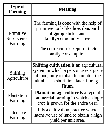
What is "Jhoom"?

Detailed Solution for MH SET Paper 2 Mock Test - 1 (Geography) - Question 2

The correct answer is A form of agriculture.

Key Points

  • "Jhoom" is a form of agriculture.
  • In this agriculture farming method, the trees and other vegetation that are present on a particular land are cut down to create the field for crop cultivation.
  • "Jhoom" is one of the oldest practices of agriculture systems.
  • Jhoom farming is also known as 'slash and burn agriculture or 'fire-fallow cultivation.
  • It is mostly practiced by the tribal groups in the northeastern states of India like Arunachal Pradesh, Meghalaya, Mizoram, and Nagaland and also in the districts of Bangladesh like Khagrachari and Sylhet.

Additional Information

1 Crore+ students have signed up on EduRev. Have you? Download the App
MH SET Paper 2 Mock Test - 1 (Geography) - Question 3

The solution to global warming requires:

Detailed Solution for MH SET Paper 2 Mock Test - 1 (Geography) - Question 3

Option 2) A combination of individual action, technological advancements, and international cooperation

Key Points

A combination of individual action, technological advancements, and international cooperation:

  • Individual actions, as mentioned earlier, contribute to positive change.
  • Technological advancements offer clean energy solutions like renewable power generation and carbon capture technologies, crucial for addressing emissions at the source.
  • Finally, international cooperation fosters global coordinated efforts, ensuring no nation is left behind and resources are pooled effectively.
  • This holistic approach holds the most promise for mitigating global warming's impact.

Additional Information

  • Focusing solely on individual lifestyle changes:

While individual actions like reducing energy consumption or adopting sustainable practices are crucial, they cannot single-handedly tackle the systemic issue of global warming. The vast majority of greenhouse gas emissions originate from industrial processes, transportation, and energy production, areas significantly influenced by broader policies and technological advancements. Individual efforts, though commendable, require support from larger frameworks to truly make a dent.

  • Relying solely on natural carbon sequestration processes:

While natural processes like forestation and wetland restoration play a vital role in absorbing carbon dioxide, relying solely on them is unrealistic and insufficient. The scale of emissions far exceeds the natural capacity for absorption, and deforestation itself contributes significantly to the problem.

  • Ignoring the issue and hoping for a natural reversal:

Ignoring the issue will only exacerbate its consequences, and hoping for a natural reversal is scientifically unfounded and irresponsible.

Important Points

  • Numerous organizations and initiatives promote individual action, technological advancements, and international cooperation, offering resources and opportunities to get involved.
  • Staying informed about climate science and policy developments empowers individuals to advocate for effective solutions.
  • The transition to a sustainable future requires innovation and investment, but the cost of inaction will be far greater in the long run
MH SET Paper 2 Mock Test - 1 (Geography) - Question 4

Which of the following is NOT a direct consequence of global warming?

Detailed Solution for MH SET Paper 2 Mock Test - 1 (Geography) - Question 4

Option 4) Expansion of deserts and decrease in overall rainfall.

Global warming is a major threat to the planet, and it is already having a number of serious consequences. These consequences include rising sea levels, increased frequency and intensity of extreme weather events, and disruption of water supplies from melting glaciers. However, not all of the options listed in the query are direct consequences of global warming.

Key Points

Expansion of deserts and decrease in overall rainfall

  • Expansion of deserts and decrease in overall rainfall is not a direct consequence of global warming.
  • While climate change can affect precipitation patterns, it is not clear whether it will lead to an expansion of deserts and a decrease in overall rainfall.
  • Global warming is a serious threat to the planet, and it is important to take action to reduce greenhouse gas emissions and mitigate its effects.

Additional Information

Rising sea levels

Rising sea levels is a direct consequence of global warming. As the Earth's atmosphere warms, the oceans expand and glaciers melt, causing sea levels to rise. Rising sea levels can lead to flooding, erosion, and other coastal hazards.

Increased frequency and intensity of extreme weather events

Increased frequency and intensity of extreme weather events is a direct consequence of global warming. As the Earth's atmosphere warms, it can hold more moisture, which can lead to more frequent and intense storms, floods, and droughts.

Disruption of water supplies from melting glaciers

Disruption of water supplies from melting glaciers is a direct consequence of global warming. As glaciers melt, they can disrupt water supplies for communities and ecosystems downstream.

MH SET Paper 2 Mock Test - 1 (Geography) - Question 5

Which is not an effect of ocean current on the socio-economic and climatic condition of the coastal region?

Detailed Solution for MH SET Paper 2 Mock Test - 1 (Geography) - Question 5

Ocean currents

  • Ocean currents are like rivers flowing in oceans.
  • They represent a regular volume of water in a definite path and direction.
  • Ocean currents are influenced by two types of forces namely :
    • Primary forces that initiate the movement of water;
    • Secondary forces that influence the currents to flow

Important Point

​​The primary forces that influence the currents are

  • Heating by solar energy
  • Wind
  • Gravity

Coriolis force

  • The Coriolis force intervenes and causes the water to move to the right in the northern hemisphere and to the left in the southern hemisphere.
  • These large accumulations of water and the flow around them are called Gyres.
  • These produce large circular currents in all the ocean basins.

Key Points

Effects of Ocean Currents

  • Ocean currents have a number of direct and indirect influences on human activities.
  • West coasts of the continents in tropical and subtropical latitudes (except close to the equator) are bordered by cool waters.
    • Their average temperatures are relatively low with narrow diurnal and annual ranges.
    • There is fog, but generally, the areas are arid.
  • West coasts of the continents in the middle and higher latitudes are bordered by warm waters which cause a distinct marine climate.
    • They are characterized by cool summers and relatively mild winters with a narrow annual range of temperatures.
  • Warm currents flow parallel to the east coasts of the continents in tropical and subtropical latitudes.
    • This results in warm and rainy climates.
    • These areas lie in the western margins of the subtropical anti-cyclones.
  • The mixing of warm and cold currents helps to replenish the oxygen and favor the growth of planktons, the primary food for the fish population.
    • The best fishing grounds of the world exist mainly in these mixing zones.

Hence, it is can be concluded from the above discussion that the deflection of wind due to the Coriolis force is not an effect of ocean current.

MH SET Paper 2 Mock Test - 1 (Geography) - Question 6
Which of the following local winds is also called "Doctor Wind"?
Detailed Solution for MH SET Paper 2 Mock Test - 1 (Geography) - Question 6
  • The Harmattan Wind in Niger which is also known as "the Doctor wind”, is a cool wind that brings relief from the major heat.
  • It is named so because of its invigorating dryness compared to the humid tropical air.
  • The Harmattan wind stream during the northern winter generally extends south of the equator as an upper air wind over the south-westerly monsoon.
MH SET Paper 2 Mock Test - 1 (Geography) - Question 7

Cirrus' refers to

Detailed Solution for MH SET Paper 2 Mock Test - 1 (Geography) - Question 7

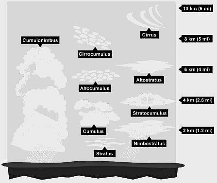
'Cirrus' refers to a high cloud.

Important Points

Cirrus Cloud:-

  • Cirrus clouds appear high in the atmosphere, above 20,000 feet (6 km).
  • Cirrus clouds are made of tiny ice crystals.
  • The atmosphere is very cold in the stratosphere where cirrus clouds occur.
  • Cirrus clouds are high-level clouds found at an altitude of 20,000 feet or higher.
  • These clouds are composed of ice crystals and are usually thin, wispy, and white.

They are sometimes called "mare's tails" because of their long, thin, and feathery appearance. Cirrus clouds usually indicate fair weather, but they can also be a sign of an approaching storm.

Additional Information

  • Cumulus clouds:-
    • These clouds form when the air cools to the dew point, the temperature at which the air can no longer hold all its water vapor.
    • These “fair weather” clouds look like cotton wool.
    • If we look at a sky filled with cumuli, we may notice they have flat bases, which all lie at the same level.
    • So, Statement 2 is correct.
  • Stratus clouds:-
    • These are composed of thin layers of clouds covering a large area of the sky.
    • This is simply mist or fog when it forms close to the ground.
    • We can easily distinguish a stratus cloud by the long horizontal layers of the cloud which have a fog-like appearance
    • So, Statement 3 is correct.
  • Nimbus Clouds:-
    • The word nimbus means a cloud that already has rain or snow falling from it.
    • These clouds are dark and seen during a thunderstorm along with thunder and lightning.
MH SET Paper 2 Mock Test - 1 (Geography) - Question 8
Consider the following statements:-

a) Von Thunen put forward his theory of agricultural location because he thought that besides physical factors, economic forces of production and transport costs are factors in the land use.

b) According to Von Thunen, perishable items in strong demand get located close to the city.

c) The assumptions such as relative transport costs are still the same and are universally true.

d) In Von Thunen’s original model, the 2nd land use ring was of livestock ranching.

Which of the following statements are correct?

Detailed Solution for MH SET Paper 2 Mock Test - 1 (Geography) - Question 8

Crops which are expensive to produce because they need skilled cultivation, much costly equipment or labour intensive picking, packing or processing for market are only profitable if transport costs can be kept low. Therefore, they must be located near city markets. Crops which require less intensive farming can stand higher costs in marketing, while crops or livestock produced on an extensive basis at low cost can stand higher transport costs and be grown at greater distance from the markets. This is the main notion of Von Thunen 's theory of Industrial location. Thus, perishable items in strong demand and those products with high transportation costs get located close to the city. Less perishable products with lower transport costs and lower market prices predominate with increasing distance from the markets.

MH SET Paper 2 Mock Test - 1 (Geography) - Question 9
Which of the following statements relating to industrial regions are correct?

(a) With shift in technology, there has been a shift in the structure of industries.

(b) The globalization has caused a new international division of labour.

(c) The high tech industrial regions have very little to no place for blue collar jobs.

(d) R&D is the most important feature of traditional large scale industrial regions.

Choose the correct option from below:

Detailed Solution for MH SET Paper 2 Mock Test - 1 (Geography) - Question 9

With the shift in technology, the structure of industries has changed considerably with the manufacturing low grade industries being shifted to the southern countries like Bangladesh, India. The advanced economies have kept the high-paying research intensive jobs within the same industries. The globalization and the unrestricted flow of capital has induced a new international division of labour where specialized goods and service is produced by workers of specific economies. Blue collar workers are characteristic of traditional heavy industries and the gold collar workers engaged R&D are characteristic of the hi-tech industries.

MH SET Paper 2 Mock Test - 1 (Geography) - Question 10
Which of the following are evidences of Continent Drift Theory?
Detailed Solution for MH SET Paper 2 Mock Test - 1 (Geography) - Question 10

The correct answer is All of the Above.

Key Points

Evidence that supports the theory:

  • The Matching of Continents (Jig-Saw-Fit): 
    • The shorelines of Africa and South America facing each other match remarkably.
  • Rocks of Same Age Across the Oceans: 
    • Radiometric dating methods have correlated the rock formation in different continents.
  • Tillite: 
    • The glacial tillite found in the Gondwana system of sediments has its resemblance to six different landmasses of the Southern Hemisphere.
  • Placer Deposits: 
    • The placer deposits of gold in the Ghana coast do not have source rock in the region. 
    • The gold deposits of Ghana have been derived from the Brazil plateau when the two continents lay side by side
  • Distribution of Fossils: 
    • Identical species of plants and animals adapted to living on land or in freshwater are found on either side of the marine barriers.

Important Points

Continental Drift Theory:

  • Alfred Wegener put forward a continental drift theory in 1912.  
  • All the continents are formed of a single Continental mass and a mega ocean surrounded the same.
  • The supercontinent was named Pangaea and the Mega Ocean was called Panthalassa.  
  • Pangea first broke into two large Continental masses Laurasia and  Gondwanaland Forming the northern and Southern components respectively. 
  • Laurasia and Gondwanaland continued to break into smaller continents that existed today.  ​
MH SET Paper 2 Mock Test - 1 (Geography) - Question 11
Which one of the following is correct for the cost-input graph of industrial production system, where point of profit maximising output is
Detailed Solution for MH SET Paper 2 Mock Test - 1 (Geography) - Question 11
Key Points

Cost-input graph of industrial production system:

  • In a cast input graph of industrial production, profit is maximized at the point at which an additional increment to output leaves profit unchanged.
  • The point at which marginal revenue equals marginal cost maximizes a company's profit.
  • The marginal cost of production measures the change in total cost of a good that arises from producing one additional unit of that good.
  • The marginal revenue is calculated by dividing the change in the total revenue by the change in the quantity.
  • From those input quantities and the price of inputs, the firm can determine the Total Cost of producing any level of output.
  • Total cost (TC) is the price of the inputs multiplied by the quantity of the inputs.

Hence, Marginal cost equals marginal revenue is correct for the cost-input graph of the industrial production system, where the point of profit-maximizing output.

MH SET Paper 2 Mock Test - 1 (Geography) - Question 12
UNFCCC (United Nations Framework Convention on Climate Change) enters into force from:
Detailed Solution for MH SET Paper 2 Mock Test - 1 (Geography) - Question 12

The UNFCCC entered into force on 21 March 1994.

Important PointsUNFCCC (United Nations Framework Convention on Climate Change):

  • The United Nations Framework Convention on Climate Change (UNFCCC) established an international environmental treaty to combat "dangerous human interference with the climate system", in part by stabilizing greenhouse gas concentrations in the atmosphere.
  • It was signed by 154 states at the United Nations Conference on Environment and Development (UNCED), informally known as the Earth Summit, held in Rio de Janeiro from 3 to 14 June 1992.
  • It established a Secretariat headquartered in Bonn and entered into force on 21 March 1994
  • The UNFCCC secretariat (UN Climate Change) is the United Nations entity tasked with supporting the global response to the threat of climate change.  
  • UNFCCC stands for United Nations Framework Convention on Climate Change.
  • The Convention has near-universal membership (197 Parties) and is the parent treaty of the 2015 Paris Agreement.
  • The main aim of the Paris Agreement is to keep the global average temperature rise this century as close as possible to 1.5 degrees Celsius above pre-industrial levels.
  • The UNFCCC is also the parent treaty of the 1997 Kyoto Protocol.
  • The ultimate objective of all three agreements under the UNFCCC is to stabilize greenhouse gas concentrations in the atmosphere at a level that will prevent dangerous human interference with the climate system, in a time frame that allows ecosystems to adapt naturally and enables sustainable development.

Hence, the correct answer is 21 March 1994

MH SET Paper 2 Mock Test - 1 (Geography) - Question 13
Consider the following statements and choose which amongst them is true:

i. Sunspots are features on the solar surface which appears as dark spot

ii. Sunspots are huge magnetic storms that occur on sun’s surface.

Choose the correct options:

Detailed Solution for MH SET Paper 2 Mock Test - 1 (Geography) - Question 13

Sunspots are the most conspicuous feature on the solar surface which appears as dark spots. The sunspots are simply the huge magnetic storms that occur on the sun’s surface. The number of sunspots increases and decreases in a cyclic manner.

Thus, the Correct answer is C.

MH SET Paper 2 Mock Test - 1 (Geography) - Question 14
Which one from the followings is NOT an effect of El-Nino? 
Detailed Solution for MH SET Paper 2 Mock Test - 1 (Geography) - Question 14

The correct answer is It lowers down the temperature of water on the Peruvian coast.

Key Points

  • El Niño is a climate pattern that affects atmospheric circulation and temperatures in the Pacific Ocean, with wide-ranging impacts on global weather and ocean conditions. 
  • El Niño distorts equatorial atmospheric circulation. This can cause significant alterations in weather patterns around the world.
  • El Niño can cause irregularities in the evaporation of sea water. It mainly changes the pattern of rainfall across the Pacific and Indian Oceans, which could lead to changes in evaporative patterns.
  • El Niño reduces the number of fish in the sea. As it disturbs water temperature and nutrient availability, El Niño could affect food chains and cause a decline in fish populations, particularly in the Eastern Pacific.
  • But, El Niño does not lower the temperature of the water on the Peruvian coast. In fact, El Niño conditions are characterized by unusually warm ocean temperatures in the Equatorial Pacific, including along the Peruvian coast, not cooler temperatures.

Additional Information

  • The term El Niño means "The Little Boy" or "Christ Child" in Spanish.
  • It was originally used by fishermen along the coasts of Ecuador and Peru to refer to the unusually warm waters that reduced their fish catches.
  • Today, El Niño refers to the broad-scale warming of the equatorial Pacific that takes place every 2-7 years and lasts between six to 18 months.
MH SET Paper 2 Mock Test - 1 (Geography) - Question 15

The term cadastral is derived from the ______ word cadestre meaning register of territorial property.

Detailed Solution for MH SET Paper 2 Mock Test - 1 (Geography) - Question 15

The term cadastral is derived from the French word cadestre meaning register of territorial property.

MH SET Paper 2 Mock Test - 1 (Geography) - Question 16
Natural change and ______ are the two factors that affect population change for a particular area.
Detailed Solution for MH SET Paper 2 Mock Test - 1 (Geography) - Question 16

Three primary factors account for population change, or how much a population is increasing or decreasing. These factors are birth rate, death rate, and migration.

  • Births and deaths are natural causes of population change. The difference between the birth rate and the death rate of a country or place is called the natural increase. The natural increase is calculated by subtracting the death rate from the birth rate.

Key Points

  • Human migration involves the movement of people from one place to another with intention of settling, permanently or temporarily, at a new location.

Additional Information

  • Zero population growth refers to a population that is unchanging – it is neither growing nor declining; the growth rate is zero.
  • Immigration is the international movement of people to a destination country of which they are not natives or where they do not possess citizenship in order to settle as permanent residents or naturalized citizens.

Natural change and Migration are the two factors that affect population change for a particular area. Therefore Option 4 is the correct answer.

MH SET Paper 2 Mock Test - 1 (Geography) - Question 17
The Glacial feature which is mostly found in groups and collectively known as ‘basket of eggs topography’ is known as-
Detailed Solution for MH SET Paper 2 Mock Test - 1 (Geography) - Question 17

Drumlins are depositional features of glaciers and are peculiar type of low round hillocks which resemble the shape of an inverted boat or half egg split lengthwise. This is the reason they are collectively known as basket of eggs topography. Drumlins are basically smooth, oval-shaped ridge like features composed of mainly glacial till with some masses of gravel and sand. The long axes of drumlins are parallel to the direction of ice movement.

MH SET Paper 2 Mock Test - 1 (Geography) - Question 18

Which of the following condition is most ideal for chemical weathering?

Detailed Solution for MH SET Paper 2 Mock Test - 1 (Geography) - Question 18

The most ideal conditions for the chemical weathering are found in Hot and humid regions. Chemical Weathering: Most intense in warm, humid climate. Very little in cold, dry climates.

MH SET Paper 2 Mock Test - 1 (Geography) - Question 19

Which of the following winds are hot dust-laden and blow from Sahara desert towards Mediterranean Region? 

Detailed Solution for MH SET Paper 2 Mock Test - 1 (Geography) - Question 19
  • Sirocco is a Mediterranean wind that comes from the Sahara and can reach hurricane speeds in North Africa and Southern Europe, especially during the summer season.
  • The Loo is a strong, dusty, hot and dry summer wind from the west which blows over the western Indo-Gangetic Plain region of North India and Pakistan.
  • A Föhn or foehn is a type of dry, warm, down-slope wind that occurs in the lee (downwind side) of a mountain range. 
  • The mistral is a strong, cold, northwesterly wind that blows from southern France into the Gulf of Lion in the northern Mediterranean, with sustained winds often exceeding 66 km/h.
MH SET Paper 2 Mock Test - 1 (Geography) - Question 20
Which of the following statements is incorrect regarding endogenic processes inside the earth?
Detailed Solution for MH SET Paper 2 Mock Test - 1 (Geography) - Question 20

The correct answer is None of the above.

Key Points

  • The endogenic and exogenic forces can cause changes in the configuration of the surface of the earth and refer to as geomorphic processes. 
    • The energy originating from within the earth is the main force behind endogenic geomorphic processes.
    • This energy is mostly produced by rotational and tidal friction, radioactivity, and primordial heat from the origin of the earth.
    • This energy due to geothermal gradients and heat flow from within induces diastrophism and volcanism in the lithosphere.
  • The energy emanating from within the earth is the main force behind endogenic geomorphic processes.
  • The earth movements are mainly of two types: diastrophism and sudden movements
  • Diastrophism:
    • All processes that move, elevate or build up portions of the earth’s crust come under diastrophism. 
    • Diastrophism is further classified into orogenic (involving mountain buildings), epeirogenic (upliftment or warping of large parts of the earth's crust), earthquake, and plate tectonic activities.
  • Sudden movements:
    • They cause considerable deformation over a short span of time and may be of two types: earthquakes and volcanoes.
MH SET Paper 2 Mock Test - 1 (Geography) - Question 21
Which of the following is an erosional landform?
Detailed Solution for MH SET Paper 2 Mock Test - 1 (Geography) - Question 21

The yardangs is an Aeolian landform. It is formed when rock is eroded forming ridges and furrows alternately in the direction of the wind. Turkistan and Mojave deserts have quite a number of yardangs.

Thus, the Correct answer is C.

MH SET Paper 2 Mock Test - 1 (Geography) - Question 22
Visibility is reduced due to the presence of high levels of pollutants, especially in cold weather when water from the air also condenses. It is known as _____
Detailed Solution for MH SET Paper 2 Mock Test - 1 (Geography) - Question 22

The correct answer is Fog.

Key Points

  • The suspended particles can be undispersed carbon particles or substances called hydrocarbons.
    • The presence of high levels of all these pollutants leads to reduced visibility, especially in cold weather when water also condenses from the air.
    • This is known as smog and is a clear sign of air pollution.

Additional Information

  • Mist is a phenomenon caused by tiny droplets of water suspended in cold air, usually by condensation. Physically, this is an example of dispersion.
  • Smoke is a collection of airborne particles and gases that are emitted when a material undergoes combustion or pyrolysis, together with amounts of air that have entered or otherwise mixed into the mass.
  • Frost is a thin layer of ice on a solid surface formed by the contact of water vapor in the cold atmosphere above a solid surface with a temperature below the freezing point, and the resulting conversion of water vapor to ice as water.
MH SET Paper 2 Mock Test - 1 (Geography) - Question 23
Which one of the following factors of a boundary determination between the areas of two competing firms is correct, if the gradients of delivered price and freight rate of firms' production is same?
Detailed Solution for MH SET Paper 2 Mock Test - 1 (Geography) - Question 23

Important PointsDelivered price and freight rate of firms:

  • Freight Rate, the cost of transporting goods, is reflective of a number of factors aside from normal transportation costs.
  • The main determining factors of freight rate are: mode of transportation (truck, ship, train, aircraft), weight, size, distance, points of pickup and delivery, and the actual goods being shipped
  • The prime concern of all the theories of industrial location is to find the ‘optimal location’, which is economically the best and one that gives maximum profits.
  • There has been a change in factors that distinguish earlier theories from contemporary reality: decrease in the importance of transport costs; increased organizational dynamism, interdependence, and variety, and the rise of corporate enterprise.

When the gradients of delivered price and freight rate of firms' production are the same, only distance from the location of firms can determine the boundary between the areas of two competing firms.

MH SET Paper 2 Mock Test - 1 (Geography) - Question 24
Which of the following is not a social theoretical approach?
Detailed Solution for MH SET Paper 2 Mock Test - 1 (Geography) - Question 24

Correct Answer: None of the above.

Key Points

  • Queer theory is the lens used to explore and challenge how scholars, activists, artistic texts, and the media perpetuate gender- and sex-based binaries, and its goal is to undo hierarchies and fight against social inequalities. In short, we will grapple with how to “queer” social work, and the limits and possibilities of such a “queering.” This will be accomplished by taking up a more critical, anti-oppressive, and liberatory stance, one that might re-shape the ways we think about and engage the individuals and communities we work alongside to achieve social justice. This course fulfills the Human Diversity Requirement.
  • Critical rationalism is the philosophy developed by Karl Popper during the middle of the 20th century. Popper's approach is based on the naturalistic idea that society has developed through a process of solving problems using trial and error.
  • The natural and social sciences have been born out of such problem solving and progressed by subjecting potential theories to vigorous testing and criticism.
  • Environmental theorists assess how people, as part of the social and physical environment, adapt and change over time. If you contemplate any rule of law, you can see how society has altered because of shifts in social ideas or ecological fluctuations. Consider the anti-tobacco laws in the United States making it illegal to smoke in public spaces as an example of social shifts towards health and wellness, or water meters to control and regulate residential water usage and waste as an example of ecological drought and prolonged water shortages in the United States. Application of environmental theory uncovers the social and environmental influences of change or areas encountering a change in social systems, policies, processes, institutions, networks, communities, organizations, and groups.
  • Environmental determinism is the study of how the physical environment predisposes societies and states towards particular development trajectories. Jared Diamond, Jeffrey Herbst, Ian Morris, and other social scientists sparked a revival of the theory during the late twentieth and early twenty-first centuries.

Additional Information

  • In using the sociological eye, each theoretical paradigm helps remove bias in assessing people and social issues at all levels of analysis (macro, meso, and micro). There as three major paradigms in the field of sociology: functionalism, conflict theory, and symbolic interactionism. Functionalism and conflict theory examine society on a macro and meso levels. Symbolic interactionism investigates micro-level interactions in society. There are also three modern or emerging paradigms in sociology: feminism, exchange theory, and environmental theory. Feminism and environment analyze macro and meso levels. Exchange theory focuses on micro-level analysis.
MH SET Paper 2 Mock Test - 1 (Geography) - Question 25
What is the median of the values 11, 7, 6, 9, 12, 15, 19 ?
Detailed Solution for MH SET Paper 2 Mock Test - 1 (Geography) - Question 25

Calculation:

Data in ascending order = 6, 7, 9, 11, 12, 15, 19

Since, n = 7 (odd)

Hence,

Median =

= 4th term = 11

∴ The median of the values is 11.

MH SET Paper 2 Mock Test - 1 (Geography) - Question 26

Which process in known as chemical weathering process?

Detailed Solution for MH SET Paper 2 Mock Test - 1 (Geography) - Question 26

Oxidation is the loss of electrons or an increase in the oxidation state of an atom by a molecule, an ion, or another atom. Reduction is the gain of electrons or a decrease in the oxidation state of an atom by a molecule, an ion, or another atom.

MH SET Paper 2 Mock Test - 1 (Geography) - Question 27
Which of the following is/are formed by subduction between a plate carrying continental crust and a plate carrying oceanic crust? 
Detailed Solution for MH SET Paper 2 Mock Test - 1 (Geography) - Question 27

The correct answer is Ocean trench.Key Points

  • Ocean trenches are formed by subduction between a plate carrying continental crust and a plate carrying oceanic crust.
  • Ocean trenches are a feature of convergent plate boundaries, where two or more tectonic plates meet.
  • At many convergent plate boundaries, dense lithosphere melts or slides beneath less-dense lithosphere in a process called subduction, creating a trench.
  • A subduction zone is a collision between two of Earth's tectonic plates, where one plate sinks into the mantle underneath the other plate.
  • A transform fault or transform boundary, is a fault along a plate boundary where the motion is predominantly horizontal.
  • Normal faults are inclined fractures where the blocks have mostly shifted vertically.

Additional Information

  • The World's deepest oceanic trench is Mariana.
  • The Mariana Trench is located in the western Pacific Ocean about 200 kilometers east of the Mariana Islands.
    • It is the deepest oceanic trench on Earth.
    • It is 1,580 miles long and averages just 43 miles wide.
    • It is home to the Challenger Deep, which, at 10,911 meters (35,797 feet), is the deepest part of the ocean.
MH SET Paper 2 Mock Test - 1 (Geography) - Question 28
Which of the research areas led to the growth of urban political geography?
Detailed Solution for MH SET Paper 2 Mock Test - 1 (Geography) - Question 28

The two main research areas, urban conflicts and the development of the concepts of electoral geography such as the geography of voting, geographical influences in voting, the geography of representation led to the development of urban political geography. Radical geography was created as after the political events of the Cold war, the geography became more politicized and this also led to Marxist geography.

MH SET Paper 2 Mock Test - 1 (Geography) - Question 29
Who among the following claimed geography to be the ‘Ecology of Man'?
Detailed Solution for MH SET Paper 2 Mock Test - 1 (Geography) - Question 29

The Correct Answer is Harlan Barrow.

Key Points

  • Harlan Barrow 1877–1960
    • H. H. Barrows, defined "Geography as Human Ecology,"
    • In the words of Barrows (1923) – “Thus defined, geography is the science of human ecology.
  • The doctrine was further strengthened by Barrows in 1922 when in his presidential address before the American Association of Geographers he emphasized that in geography human ecology is the guiding concept
  • In the words of Barrows (1923) “Thus defined, geography is the science of human ecology. The implications of the term "human ecology" make evident at once what I believe will be in the future the objective of geographic inquiry.

Additional Information

  • Let's have a look at other options:
  • Alfred Hettner
    • Alfred Hettner is known for his many distinguished accomplishments and is also credited have pushed the chorology concept to some new academic vistas
    • Based upon this concept Richard Hartshorne built up the edifice of his idea of ‘Areal Differentiation’.
  • Vidal-de la Blache
    • ​He was a French geographer. He is considered to be the founder of modern French geography and also the founder of the French School of Geopolitics.
  • Otto Schluter
    • He is credited with the creation of the term cultural landscape which is one of the turning points in geographical history. Otto Schlüter studied 1891-1898 geography, geology, mineralogy, and philosophy first in Freiburg in Breisgau, and later in Halle and Berlin.
MH SET Paper 2 Mock Test - 1 (Geography) - Question 30
What is the average temperature of the oceanic water at the surface?
Detailed Solution for MH SET Paper 2 Mock Test - 1 (Geography) - Question 30

The top layer of the ocean is called as surface layer. The sun heats the water in the surface layer and thus the temperature of the surface layer is higher than the lower layers. The average temperature at the surface is 170 C. This temperature also varies in polar and equatorial areas.

View more questions
60 tests
Information about MH SET Paper 2 Mock Test - 1 (Geography) Page
In this test you can find the Exam questions for MH SET Paper 2 Mock Test - 1 (Geography) solved & explained in the simplest way possible. Besides giving Questions and answers for MH SET Paper 2 Mock Test - 1 (Geography), EduRev gives you an ample number of Online tests for practice

Top Courses for MAHA TET

Download as PDF

Top Courses for MAHA TET