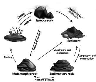
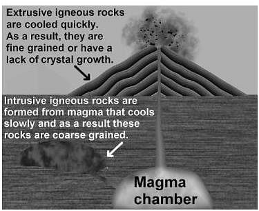
MAHA TET Exam  >  MAHA TET Tests  >  MH SET Mock Test Series 2024  >  MH SET Paper 2 Mock Test - 10 (Geography) - MAHA TET MCQ

MH SET Paper 2 Mock Test - 10 (Geography) - MAHA TET MCQ


Test Description

30 Questions MCQ Test MH SET Mock Test Series 2024 - MH SET Paper 2 Mock Test - 10 (Geography)

MH SET Paper 2 Mock Test - 10 (Geography) for MAHA TET 2024 is part of MH SET Mock Test Series 2024 preparation. The MH SET Paper 2 Mock Test - 10 (Geography) questions and answers have been prepared according to the MAHA TET exam syllabus.The MH SET Paper 2 Mock Test - 10 (Geography) MCQs are made for MAHA TET 2024 Exam. Find important definitions, questions, notes, meanings, examples, exercises, MCQs and online tests for MH SET Paper 2 Mock Test - 10 (Geography) below.
Solutions of MH SET Paper 2 Mock Test - 10 (Geography) questions in English are available as part of our MH SET Mock Test Series 2024 for MAHA TET & MH SET Paper 2 Mock Test - 10 (Geography) solutions in Hindi for MH SET Mock Test Series 2024 course. Download more important topics, notes, lectures and mock test series for MAHA TET Exam by signing up for free. Attempt MH SET Paper 2 Mock Test - 10 (Geography) | 100 questions in 120 minutes | Mock test for MAHA TET preparation | Free important questions MCQ to study MH SET Mock Test Series 2024 for MAHA TET Exam | Download free PDF with solutions
MH SET Paper 2 Mock Test - 10 (Geography) - Question 1

Considering the insolation received in 100, which of the following statements is/are correct regarding the heat budget of the Earth?

1. Around 35 units are reflected back before reaching the surface of the Earth.

2. 65 units are absorbed by the atmosphere and the Earth’s surface.

3. The earth radiates back 51 units as terrestrial radiation.

Select the correct answer from the options given below.

Detailed Solution for MH SET Paper 2 Mock Test - 10 (Geography) - Question 1
  • The earth as a whole does not accumulate or lose heat. It maintains its temperature.
  • This can happen only if the amount of heat received in the form of insolation equals the amount lost by the earth through terrestrial radiation.
  • Consider that the insolation received at the top of the atmosphere is 100 percent.
  • While passing through the atmosphere some amount of energy is reflected, scattered and absorbed. Only the remaining part reaches the earth surface.
  • Roughly 35 units are reflected back to space even before reaching the earth’s surface. Of these, 27 units are reflected back from the top of the clouds and 2 units from the snow and ice-covered areas of the earth. The reflected amount of radiation is called the albedo of the earth.
  • The remaining 65 units are absorbed, 14 units within the atmosphere and 51 units by the earth’s surface.
  • The earth radiates back 51 units in the form of terrestrial radiation. Of these, 17 units are radiated to space directly and the remaining 34 units are absorbed by the atmosphere (6 units absorbed directly by the atmosphere, 9 units through convection and turbulence and 19 units through latent heat of condensation).
  • 48 units absorbed by the atmosphere (14 units from insolation +34 units from terrestrial radiation) are also radiated back into space.
  • Thus, the total radiation returning from the earth and the atmosphere respectively is 17 + 48 = 65 units which balance the total of 65 units received from the sun.
  • This is termed the heat budget or heat balance of the earth.
  • This explains why the earth neither warms up nor cools down despite the huge transfer of heat.
MH SET Paper 2 Mock Test - 10 (Geography) - Question 2

Which of the following factors influence the distribution of the population?

1. Landforms

2. Minerals

3. Soils

4. Industrialization

Select the correct answer from the code given below:

Detailed Solution for MH SET Paper 2 Mock Test - 10 (Geography) - Question 2

The correct answer is 1, 2, 3, and 4.

Important Points

FACTORS INFLUENCING THE DISTRIBUTION OF POPULATION:

  • Geographical Factors:
    • Availability of water: It is the most important factor for life. So, people prefer to live in areas where fresh water is easily available. Water is used for drinking, bathing, and cooking – and also for cattle, crops, industries, and navigation.
    • Landforms: People prefer living on flat plains and gentle slopes. This is because such areas are favorable for the production of crops and to build roads and industries.
    • Climate: An extreme climate such as very hot or cold deserts are uncomfortable for human habitation. Areas with a comfortable climate, where there is not much seasonal variation attract more people.
    • Soil: Fertile soils are important for agricultural and allied activities. Therefore, areas that have fertile loamy soils have more people living on them as these can support intensive agriculture.
  • Economic Factors:
    • Minerals: Areas with mineral deposits attract industries. Mining and industrial activities generate employment. So, skilled and semi-skilled workers move to these areas and make them densely populated.
    • Urbanisation: Cities offer better employment opportunities, educational and medical facilities, better means of transport and communication. It leads to rural to urban migration and cities grow in size.
    • Industrialisation: Industrial belts provide job opportunities and attract large numbers of people. These include not just factory workers but also transport operators, shopkeepers, bank employees, doctors, teachers, and other service providers.
  • Social and Cultural Factors:
    • Some places attract more people because they have religious or cultural significance.
    • In the same way – people tend to move away from places where there is social and political unrest.
1 Crore+ students have signed up on EduRev. Have you? Download the App
MH SET Paper 2 Mock Test - 10 (Geography) - Question 3

During El Nino period the temperature rises rapidly once in three to eight years along the coast of ………………

Detailed Solution for MH SET Paper 2 Mock Test - 10 (Geography) - Question 3

During El Nino period the temperature rises rapidly once in three to eight years along the coast of Peru and Ecuador.

MH SET Paper 2 Mock Test - 10 (Geography) - Question 4

The highest per capita emitter of Carbon dioxide in the world is :

Detailed Solution for MH SET Paper 2 Mock Test - 10 (Geography) - Question 4

The highest per capita emitter of Carbon dioxide in the world is Qatar. The biggest absolute emissions come from China and the United States. In terms of CO2 emissions per capita, China is ranked only ranked 47th, at 7.5 metric tonnes per capita. The US is ranked 11th at 16.5 per capita and amongst countries with sizeable populations, has the highest CO2 emissions per capita.

MH SET Paper 2 Mock Test - 10 (Geography) - Question 5
Which of the following statements are true about John Friedmann’s Matter of the Centre Vs. Periphery?

(a) The theory is similar to Growth Pole Theory by Francis Perroux.

(b) Development poles are urban centers with many economic activities which are diversified in nature.

(c) The central town is the supplier of commodities for consumption.

(d) The central district provides raw material to the peripheral towns.

Select the correct answer from the codes given below:

Detailed Solution for MH SET Paper 2 Mock Test - 10 (Geography) - Question 5

John Friedmann presented his theory in 1966 about the difference central town and periphery. The theory makes two parts of developing town, as given by Francis Perroux. The theory divides a developing towns/poles into f types: Central cities, growth poles, development poles and integration poles. The development poles are urban districts which have diversified economic activities. The central town or pole is centre of development. The finished product is available here for input into tertiary activities and for consumption. It takes the required raw materials from towns in periphery.

Thus, the correct answer is A.

MH SET Paper 2 Mock Test - 10 (Geography) - Question 6
Which of the following is not an example of spatial data?
Detailed Solution for MH SET Paper 2 Mock Test - 10 (Geography) - Question 6

The correct answer is option 3.

Concept:

Spatial data:

Spatial data is any kind of data that refers to a certain geographical region or place, either directly or indirectly. Spatial data, also known as geospatial data or geographic information, can quantitatively represent a physical item in a geographic coordinate system.

Example of spatial data:

A common example of spatial data can be seen in a road map.

A road map is a two-dimensional object that contains points, lines, and polygons that can represent cities, roads, and political boundaries such as states or provinces. A road map is a visualization of geographic information.

The location of cities, roads, and political boundaries that exist on the surface of the Earth is projected onto a two-dimensional display or piece of paper, preserving the relative positions and relative distances of the rendered objects.

Hence the correct answer is times of particular events.

MH SET Paper 2 Mock Test - 10 (Geography) - Question 7
Consider the following statements on application areas of remote sensing and choose which amongst them is true:

i. Remote sensing is used in crop acreages estimation

ii. Different methods of remote sensing are used in soil categorization.

iii. Remote sensing is used in lithological discrimination

iv. Various methods of remote sensing are also used in major river valley projects. .

Detailed Solution for MH SET Paper 2 Mock Test - 10 (Geography) - Question 7

Remote sensing is used to acquire the data of remotely sensed areas. It is used in the fields like crop acreages estimation, lithological discrimination, coral reef mapping, forest cover mapping, loss of biological diversity, wealth of oceans, oil fields detection, major river valley projects, management of wild rivers, environment impact analysis amongst many others.

Thus, the Correct answer is D.

MH SET Paper 2 Mock Test - 10 (Geography) - Question 8

Given below are two statements, one labelled as assertion(A) and other labelled as reason(R).

Assertion(A)- Aerial photographs are more useful when spatial detail is more critical than spectral information.

Reason(R)- Aerial photograph’s spectral resolution is generally coarse.

Detailed Solution for MH SET Paper 2 Mock Test - 10 (Geography) - Question 8

Aerial photographs are most useful when fine spatial detail s more critical than spectral information, as their spectral resolution is generally coarse when compared to data captured with electronic sensing devices. The geometry of vertical devices is well understood and it is possible to make very accurate measurements from them.

MH SET Paper 2 Mock Test - 10 (Geography) - Question 9
Globigerina ooze is
Detailed Solution for MH SET Paper 2 Mock Test - 10 (Geography) - Question 9

The Correct Answer is Pelagic deposit.​

Key Points

  • This Globigerina ooze is the most densely spread of the oozes which occur both in the Atlantic and in the Indian oceans. While Pteropod ooze is found in the middle of the Atlantic.
  • globigerina ooze a layer of soft mud made up in large part of the shells of dead globigerina and covering great areas of the sea bottom at depths of 1000 to 3000 feet.
  • globigerina ooze formed
    • Globigerina ooze Deep-sea ooze in which at least 30% of the sediment consists of planktonic Foraminiferida, including chiefly Globigerina.
    • It is the most widespread deposit to form from the settling out of material from overlying waters, covering almost 50% of the deep-sea floor.

MH SET Paper 2 Mock Test - 10 (Geography) - Question 10

Consider the following statements:

1. Indian Mahogany species is well-known for its dense, redwood.

2. Mahogany can be found in almost every part of India.

3. Indian scientists discovered that the mahogany tree emits a sulphur compound that can help to reduce atmospheric warming caused by greenhouse gases.

4. Mahogany is considered a Mesophyte.

5. It is a fast-growing upright tree with an outwardly rounded symmetrical crown.

How many of the above statements are correct? 

Detailed Solution for MH SET Paper 2 Mock Test - 10 (Geography) - Question 10

The correct answer is All five.

Key Points

Indian mahogany trees

  • It can grow to be 30-40 feet tall.
  • It is a fast-growing upright tree with an outwardly rounded symmetrical crown. Hence, Statement 5 is correct.
  • It has a spread of 20-30 feet.
  • The fruit is a large greenish-brown capsule that splits into five sections, each containing flat, long-winged, light brown seeds.
  • It is made of red-brown Indian-mahogany-trees wood. On the same plant, both male and female flowers are produced.
  • Mahogany is considered a Mesophyte. Hence, Statement 4 is correct.
  • The bark is smooth and dark brown. The leaves are pinnate and range in length from 12 to 25 cm, with four to eight leaflets.
  • The species is well-known for its dense, redwood. Hence, Statement 1 is correct.
  • Initially, the Spanish and English used mahogany to build ships. Then it was used in furniture.
  • The Spanish were the first to do this, but English workshops used it extensively in the 18th and early 19th centuries. This epoch is known as the "Age of Mahogany."
  • Other names for Indian Mahogany include Mahogany, West Indian Mahogany, Spanish mahogany, Madeira redwood, acajou, caoba, caoba de Santo, cheria mahogany, Cuban mahogany, American mahogany, True mahogany, small leaf mahogany, and Dominican mahogany.
  • Mahogany can be found in almost every part of India. It is also found in India's Thattekkad Wildlife Sanctuary, Kaziranga National Park, and Corbett National Park. Hence, Statement 2 is correct.
  • Indian scientists discovered that the mahogany tree emits a sulphur compound that can help to reduce atmospheric warming caused by greenhouse gases. Hence, Statement 3 is correct.
MH SET Paper 2 Mock Test - 10 (Geography) - Question 11

Given below are two statements. One is labelled as Assertion (A) and the other is labelled as Reason (R).

Assertion(A) : Unsupervised Classification normally requires only a minimal amount of input from the analyst.

Reason(R) : A priori knowledge of the scene or training sites are required to run this classification.
Select the correct answer from options given below :

Detailed Solution for MH SET Paper 2 Mock Test - 10 (Geography) - Question 11

Unsupervised classification is a process whereby numerical operations are performed by the computer system itself that search for the natural groupings of the spectral properties of pixels in the multi spectral feature space. This method doesn't require much initial output and a priori knowledge of the scene as clustering does not involve training data.

Thus, the Correct answer is C.

MH SET Paper 2 Mock Test - 10 (Geography) - Question 12

What is the correct sequence of occurrence of various atmospheric layers from earth's surface?

1. Exosphere

2. Stratosphere

3. Troposphere

Choose the correct answer from the options given below

Detailed Solution for MH SET Paper 2 Mock Test - 10 (Geography) - Question 12

The correct answer is 321.

Key Points

  • It envelops our world, keeps us warm, provides us with oxygen to breathe, and is the source of our weather.
  • The six layers that make up the Earth's atmosphere are troposphere, stratosphere, mesosphere, thermosphere, ionosphere, and exosphere.
  • The troposphere is our atmosphere's lowest layer. It rises from the ground to a height of around 10 kilometres above sea level.
  • The stratosphere is situated 50 kilometres above sea level.
  • The mesosphere is located above the stratosphere. It reaches a height of around 85 kilometres (53 miles) above our planet.
  • The exosphere is the outermost layer of the atmosphere.

Therefore, Troposphere⇒Stratosphere⇒Mesosphere

Additional Information

  • The ionosphere is not a discrete layer.
  • The ionosphere is a succession of zones in the mesosphere and thermosphere where high-energy solar radiation has thrown electrons lose from their parent atoms and molecules.
MH SET Paper 2 Mock Test - 10 (Geography) - Question 13
According to census 2011, which state has highest decadal population growth rate between 2001 - 11?
Detailed Solution for MH SET Paper 2 Mock Test - 10 (Geography) - Question 13
The correct answer is Meghalaya.
Key Points
  • Meghalaya has the highest decadal population growth rate between 2001-11, according to the census data of 2011.
  • Meghalaya's population grew at a rate of 27.8% during this period, which is the highest among all states in India.
  • The population growth rate of Bihar during the same period was 25.1%, making it the third-highest state in terms of population growth rate.
  • Arunachal Pradesh had a population growth rate of 25.9%, making it the second-highest state in terms of population growth rate.
  • Mizoram had a population growth rate of 22.8%, which is comparatively lower than the other three options.
Additional Information
  • Decadal population growth rate refers to the percentage increase in population over a period of ten years.
  • Bihar is the most populous state in India with over 100 million people, and it also has one of the highest population densities in the country.
  • Arunachal Pradesh is one of the least populous states in India, with a population of less than 1.5 million people.
  • Mizoram is a small northeastern state with a population of just over 1 million people. It is known for its scenic beauty and rich cultural heritage.
MH SET Paper 2 Mock Test - 10 (Geography) - Question 14

Match List – I with List-II and select the correct answer using the codes given below:
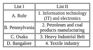
Detailed Solution for MH SET Paper 2 Mock Test - 10 (Geography) - Question 14
MH SET Paper 2 Mock Test - 10 (Geography) - Question 15

Which port was developed as a satellite port of Mumbai Port?

Detailed Solution for MH SET Paper 2 Mock Test - 10 (Geography) - Question 15

The correct answer is Jawaharlal Nehru Port.

Key Points

  • Jawaharlal Nehru Port:
    • Jawaharlal Nehru Port was developed as a satellite port of Mumbai Port.
    • Jawaharlal Nehru Port at Nhava Sheva was developed as a satellite port to relieve the pressure at the Mumbai port.
    • It is the largest container port in India.
    • It is located in Mumbai, in the state of Maharashtra.
    • JNPT handles the majority of India's containerized trade and is the focal point of long-haul calls to and from the emerging market economy.

Additional Information

  • Marmagao Port: Marmagao Port, situated at the entrance of the Zuari estuary, is a natural harbour in Goa.
  • Kandla Port: situated at the head of the Gulf of Kuchchh has been developed as a major port to cater to the needs of western and northwestern parts of the country and also to reduce the pressure at Mumbai port.
  • New Mangalore Port: It is located in the state of Karnataka and caters to the needs of the export of iron-ore and iron concentrates.
MH SET Paper 2 Mock Test - 10 (Geography) - Question 16

Which among the following state produces maximum raw silk in India?

Detailed Solution for MH SET Paper 2 Mock Test - 10 (Geography) - Question 16

Karnataka accounted for as much as 60% of the country’s raw silk output.

Thus, the correct answer is D.

MH SET Paper 2 Mock Test - 10 (Geography) - Question 17
Asthenosphere is a part of ______________.
Detailed Solution for MH SET Paper 2 Mock Test - 10 (Geography) - Question 17

The correct answer is Earth's Mantle.

Key Points

  • Asthenosphere:
    • The asthenosphere is the denser, weaker layer beneath the lithospheric mantle.
    • It lies between about 100 kilometers (62 miles) and 410 kilometers (255 miles) beneath Earth's surface.
    • The temperature and pressure of the asthenosphere are so high that rocks soften and partly melt, becoming semi-molten.
    • The asthenosphere is generally more viscous than the lithosphere, and the lithosphere-asthenosphere boundary (LAB) is the point where geologists and rheologists, scientists who study the flow of matter mark the difference in ductility between the two layers of the upper mantle.

So, it is clear that the Asthenosphere is located beneath the crust and the crustal plates are moving over this layer.

MH SET Paper 2 Mock Test - 10 (Geography) - Question 18
The concept of ‘Ecological niche’ was introduced by _______.
Detailed Solution for MH SET Paper 2 Mock Test - 10 (Geography) - Question 18

Correct Answer: J. Grinnell.

Key Points

  • The ecological niche of a species has been defined by the resources it requires and by its role or function in the environment. The concept of the ecological niche when introduced by Grinnell (1917) focused on the habitat requirements of a species for it to survive and reproduce.
  • The concept of the ecological niche was first introduced by Joseph Grinnell in 1917. focused on the environmental factors that determined where a species could survive rather than interactions between species. Around the same time, an English ecologist named Charles Elton was developing his own ideas about niches. In his definition, a species’ niche was determined by its interactions with other species—namely its relationships with food and predators
  • A plant's or animal's niche, or more correctly, ecological niche, is a way of life that is unique to that species. Niche and habitat are not the same. While many species may share a habit, this is not true for a niche. Each plant and animal species is a member of a community. The niche describes the species' role or function within this community.
  • Almost 40 years later, in the late 1950s, English ecologist G. Evelyn Hutchinson blended these two versions into a broader definition. This definition considers all abiotic and biotic factors that influence a species in a quantifiable way. This definition is still used by scientists today. It is important to keep learning about species’ niches today because it can help us understand how organisms will respond to environmental changes caused by humans.

Additional Information

  • In ecology, a niche is a term with a variety of meanings related to the behavior of a species living under specific environmental conditions. The ecological niche describes how an organism or population responds to the distribution of resources and competitors. The ecological niche concept expresses the relationship of an individual or a population to all aspects of its environment. Studies on the relationship between the human population and environmental resources have employed a niche concept. The ecological niche comprehends all conditions necessary for an organism to exist.
  • In ecology, the term “niche” describes the role an organism plays in a community. A species’ niche encompasses both the physical and environmental conditions it requires (like temperature or terrain) and the interactions it has with other species (like predation or competition).
  • For example, the rare Kirtland’s warbler (Setophaga kirtlandii), a small songbird of North America, has a very limited niche. It nests only among young jack pine trees (Pinus banksiana), which require periodic wildfires for their seeds to germinate. In this environment, one of the species interactions it must contend with is nest parasitism by the brown-headed cowbird (Molothrus ater). Cowbirds lay their eggs in nests built by other bird species and these host birds then incubate and raise the cowbird’s young, often at the expense of their own babies.
MH SET Paper 2 Mock Test - 10 (Geography) - Question 19
Arrange the following states according to the production of rice in descending order

a) Chhattisgarh

b) Odisha

c) Punjab

d) Uttar Pradesh

Choose the correct option:

Detailed Solution for MH SET Paper 2 Mock Test - 10 (Geography) - Question 19

Uttar Pradesh ranks 2nd in terms of rice production and has shown unprecedented progress in the recent years. About 13.82% of country's rice is produced here and availability of HYV seeds, irrigation facilities are the major factors for its development. After that, Punjab records an annual growth of over 12%. The major production comes Patiala, Ludhiana, Amritsar. Odisha produces about 7 % rice of India and Chhattisgarh comes right after that.

MH SET Paper 2 Mock Test - 10 (Geography) - Question 20
The Chaudhary Charan Singh Airport is located in
Detailed Solution for MH SET Paper 2 Mock Test - 10 (Geography) - Question 20

Chaudhary Charan Singh International Airport is located in Uttar Pradesh and serves Lucknow. It was earlier known as Amausi airport.

MH SET Paper 2 Mock Test - 10 (Geography) - Question 21

Consider the following statements regarding types of rocks:

1. In general, metallic minerals are found in igneous and metamorphic rock.

2. Igneous and metamorphic rock forms large plateaus.

3. Coal and Petroleum are found in the sedimentary strata.

Select the correct answer using the code given below.

Detailed Solution for MH SET Paper 2 Mock Test - 10 (Geography) - Question 21

The correct answer is 1, 2 and 3Key Points 

  • Minerals occur in different types of rocks such as Igneous Rocks, Metamorphic Rocks and Sedimentary Rocks.

Metamorphic Rocks:

  • They are formed from other rocks that are changed by heat and pressure underground.
  • Some examples of metamorphic rocks are: 
    • gneissslatemarbleschist and quartzite.
  • It is formed when existing rock is transformed physically or chemically at elevated temperatures, without actually melting to any great degree.
  • Metallic Minerals found in igneous and metamorphic rock:
    •  Iron ore in north Sweden, Copper and Nickel deposits in Ontario, Canada, iron, nickel, chromites and platinum in South Africa. Hence Statement 1 is correct.
  • Igneous and metamorphic rock forms large plateaus as they are more stable. Hence Statement 2 is correct.

Sedimentary Rocks:

  • Sedimentary rocks are type of rock that are formed by the accumulation or deposition of mineral or organic particles at the Earth's surface, followed by cementation.
  • Sedimentary rocks are formed from layers of sand, silt, dead plants, and animal skeletons.
  • Common sedimentary rocks include sandstonelimestone and shale.
  • Sedimentary rocks are deposited in layers as strata, forming a structure called Bedding.
  • Sedimentary rock formations of plains and young fold mountains contain non-metallic minerals like limestone.
  • Coal and Petroleum are found in the sedimentary strata. Hence Statement 3 is correct.

Additional Information

Igneous Rocks:

  • Igneous rocks are formed from melted rock deep inside the Earth.
  • Most of the Earth's oceanic crust is made of igneous rock.
  • Igneous rock is formed through the cooling and solidification of magma or lava.
  • Solidification into rock occurs either:
    • Intrusive Rocks: formed below the surface of the earth
    • Extrusive Rocks: formed on the surface of the earth
  • Igneous rock may form with crystallization to form granular, crystalline rocks, or without crystallization to form natural glasses.
  • Some examples of igneous rocks are Granite, Basalt and Pumice.

MH SET Paper 2 Mock Test - 10 (Geography) - Question 22

Direction: The following item consists of two statements, statement 1 and statement 2. Examine these two statements carefully and select the correct answer from the code given below.

Statement 1:

The salinity of oceans is relatively higher near the equator than in other regions.

Statement 2:

The Equator region has heavy rainfall, high relative humidity and calm air.

Detailed Solution for MH SET Paper 2 Mock Test - 10 (Geography) - Question 22

The correct answer is Option 4 is correct.

Key Points

  • Generally, salinity decreases from the equator towards the pole but the highest salinity is seldom recorded near the tropics (30° N and 20° W - 60° W).
  • Near the equator, there is heavy rainfall, high relative humidity, cloudiness, and calm air of the doldrums.
  • The maximum oceanic salinity (37ppt) is observed between 20° N and 30° N and 20° W - 60° W. It gradually decreases towards the north. Hence, Statement 1 is not correct
  • The polar areas experience very little evaporation and receive large amounts of fresh water from the melting of ice. This leads to low levels of salinity, ranging between 20ppt and 32ppt.
  • One needs to understand here that statement first is correct.
  • On average, salinity decreases from the equator towards the poles.
  • However, it is important to note that the highest salinity is seldom recorded near the equator though this zone records high temperature and evaporation high rainfall reduces the relative proportion of salt. Thus, the equator accounts for only 35‰ salinity.
  • If we talk about the statement of Reason- it is incorrect because Salinity further decreases in the polar zones because of the influx of Glacial melt-water.
MH SET Paper 2 Mock Test - 10 (Geography) - Question 23
Which of the following statements is not correct regarding wind power capacity in India?
Detailed Solution for MH SET Paper 2 Mock Test - 10 (Geography) - Question 23

The correct answer is Madhya Pradesh has third rank in the country in wind power capacity.

Key PointsWind power capacity of India:

  • India has emerged as one of the world's leaders in wind power capacity.
  • The country has set ambitious targets for wind energy development, aiming to achieve 60 GW of wind power capacity by 2022.
  • Several states in India have favorable conditions for wind energy, including Tamil Nadu, Gujarat, Maharashtra, Rajasthan, and Karnataka.
  • Tamil Nadu has the highest wind power capacity among all states in India, followed by Gujarat and Maharashtra.
  • Tamil Nadu's wind power capacity was about 24% of the country in the year 2021.
  • Gujarat has around 22% of the total wind power capacity of the country.
  • Madhya Pradesh ranks 8th in the total wind power capacity in the country.
  • The government of India has implemented various policies and incentives to promote wind energy, such as the generation-based incentive (GBI) scheme and the accelerated depreciation benefit.
  • India has also been actively promoting offshore wind energy projects, particularly along the coasts of Gujarat and Tamil Nadu.
  • The growth of wind power in India has contributed to reducing the country's dependence on fossil fuels and mitigating greenhouse gas emissions.
MH SET Paper 2 Mock Test - 10 (Geography) - Question 24
The idea of urban revolution due to growth of technology and presence of food surplus was stated by
Detailed Solution for MH SET Paper 2 Mock Test - 10 (Geography) - Question 24

Gordon V. Childe was a famous archeologist. He gave theory about Urban Revolution. The origin and development of cities was part of this theory. This theory described the transition of pre-literate agricultural civilization into civilized societies. The causes for Urban Revolution were growth of revolution, food surplus and availability of capital.

MH SET Paper 2 Mock Test - 10 (Geography) - Question 25

With reference to Peninsular India, consider the following statements:

1. Dodabetta is the highest peak of the Peninsular Plateau located on the Western Ghats.

2. The Karbi-Anglong plateau is an extension of the peninsular plateau.

3. Peninsular rivers are characterized by fixed course, defined meanders, and non-perennial flow of water. 

4. It is mostly composed of igneous and metamorphic rocks.

How many of the statements given above are correct?

Detailed Solution for MH SET Paper 2 Mock Test - 10 (Geography) - Question 25

The correct answer is ​Only two

Key Points

Western Ghats

  • Westen Ghats are comparatively higher in elevation and more continuous than the Eastern Ghats.
  • Anaimudi’ (2,695 m), the highest peak of Peninsular plateau is located on the Anaimalai hills of the Western Ghats followed by Dodabetta (2,637 m) on the Nilgiri hills. Hence, statement 1 is incorrect.
  • Delhi ridge in the northwest, (extension of Aravalis), the Rajmahal hills in the east, Gir range in the west and the Cardamom hills in the south constitute the outer extent of the Peninsular plateau. However, an extension of this is also seen in the northeast, in the form of Shillong and Karbi-Anglong plateau. Hence, statement 2 is correct.

Peninsular Rivers

  • They are characterised by fixed course, Absence of Meanders and non-perennial flow of water.
  • The Narmada and the Tapi which flow through the rift valley are, however, exceptions. Hence, Statement 3 is Incorrect.
  • It is composed of the Igneous and metamorphic rocks. Hence, Statement 4 is correct.
    • The Indian Peninsular was a part of Gondwana land. The Peninsular plateau is the oldest landmass as it was formed due to the breaking and drifting of the Gondwana land. 

Additional Information

Peninsular Plateau of India:

  • Rising from the height of 150 m above the river plains up to an elevation of 600-900 m is the irregular triangle known as the Peninsular plateau.
  • The general elevation of the plateau is from the East to the West, which is also proved by the pattern of the flow of rivers.
  • Some of the important physiographic features of this region are tors, block mountains, rift valleys, spurs, bare rocky structures, series of hummocky hills and wall-like quartzite dykes offering natural sites for water storage.
  • The western and northwestern part of the plateau has an emphatic presence of black soil.
  • On the basis of the prominent relief features, the Peninsular plateau can be divided into three broad groups:
    • The Deccan Plateau
    • The Central Highlands
    • The Northeastern Plateau
MH SET Paper 2 Mock Test - 10 (Geography) - Question 26

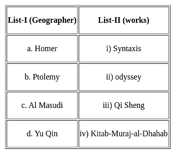
Match the list one with list two.

Choose the correct option from below :

Detailed Solution for MH SET Paper 2 Mock Test - 10 (Geography) - Question 26

In the ancient period geography grew out of exploration, mapping of areas and materials collected. Some of the most prominent geographers of the ancient times were Arabs, Greeks, Chinese, Indians and Romans.

Odyssey is the work of Homer who is a Roman geographer.

Syntaxis is the work of Ptolemy who is a Greek geographer.

Kitab-Muraj-al-Dhahab is the work of Al Masudi who is an Arab Geographer

Qi Sheng is the work of Yu Qin who is a Chinese geographer

Thus, the Correct answer is B.

MH SET Paper 2 Mock Test - 10 (Geography) - Question 27
Where is ‘Dudhsagar Waterfall' situated in India :
Detailed Solution for MH SET Paper 2 Mock Test - 10 (Geography) - Question 27

The correct answer is At the border of the Indian state of Goa and Karnataka.

Key Points

  • Dudhsagar Waterfall is located on the Mandovi River in the Indian state of Goa.
  • It is situated right at the border between Goa and Karnataka state.
  • The waterfall is located in the Bhagwan Mahaveer Sanctuary and Mollem National Park.
  • With a height of 310 meters (1017 feet), it is one of the tallest waterfalls in India.
  • 'Dudhsagar' literally means 'Sea of Milk' in Hindi. The waterfall got its name because when the water cascades, it appears like milk flowing over the rocky cliffs.

Additional Information

  • Karnataka has many waterfalls like Jog Falls, Abbey Falls, Irupu falls etc.
  • Gujarat has waterfalls such as Dhuandhar falls, Veri waterfalls etc.
  • Rajasthan is mostly arid but does have a few waterfalls like Bathing ghat falls.
MH SET Paper 2 Mock Test - 10 (Geography) - Question 28

Match the following local storms with their correct definition:

I. Mango Shower -  A) Pre-Monsoon showers which help in blossoming of coffee flowers

II. Blossom Shower  -  B) Pre-Monsoon showers which help in the ripening of mangoes

III. Nor Westers - C) Hot, dry and oppressing winds blowing in Northern plains

IV. Loo - D) Evening thunderstorms in Bengal and Assam

Detailed Solution for MH SET Paper 2 Mock Test - 10 (Geography) - Question 28

Answer: Option 2) IB, IIA, IIID, IVC.

Additional Information 

1. Mango Shower: 

  • Mango showers are pre-monsoon showers common in the states of Karnataka and Kerala in India.
  • These showers occur at the end of the summer season and help in the ripening of mangoes. 
  • Mango showers are also known as 'blossom showers' in some parts of India.

2. Blossom Shower:

  • Blossom showers are local storms or winds that help in the blossoming of coffee flowers.
  • These showers occur in the early spring season and are essential for the coffee crop.
  • Blossom showers are also known as 'cherry showers' in some parts of the world

3. Nor westers:

  • Nor westers are violent thunderstorms that occur in the Gangetic plains of India and Bangladesh.
  • These storms are characterized by strong winds, heavy rain, and lightning.
  • Nor westers can cause significant damage to crops and infrastructure.
  • They occur during the pre-monsoon season (March-May) and are often associated with squall lines.

4. Loo:

  • Loo is a strong, dry, and hot wind that blows in the northern plains of India and Pakistan.
  • Loo winds are common during the summer season (April-June) and can cause heatstroke and other health problems.
  • These winds can also cause significant damage to crops and vegetation.
  • Loo winds are also known as 'hot winds' or 'dust storms' in some parts of the world.

Hence, the correct answer is: Option 2) IB, IIA, IIID, IVC

MH SET Paper 2 Mock Test - 10 (Geography) - Question 29

Consider the following statements. Identify the right ones: 

I. Monsoon refers the climate associated with seasonal reversal in the direction of winds.

II. India has hot monsoonal climate.

Detailed Solution for MH SET Paper 2 Mock Test - 10 (Geography) - Question 29

The term "monsoon" refers to a seasonal reversal in the direction of winds, which is accompanied by significant changes in precipitation patterns. Monsoonal climates are characterized by distinct wet and dry seasons, with the wet season coinciding with the period when the winds blow from the ocean towards the land. India, located in South Asia, experiences a monsoonal climate. 

Key Points

1. Monsoon refers the climate associated with seasonal reversal in the direction of winds.

  •  Monsoon indeed refers to the climate associated with the seasonal reversal in the direction of winds.
  • This seasonal reversal is driven by the differential heating of land and water bodies, which creates pressure gradients that cause winds to change direction.

2. India has hot monsoonal climate.

  • India has the climate of Tropical monsoon due to its peculiar position in the Asian continent and the Indian Ocean.
  • The Indian subcontinent has hot summers and moderately cold winters.
  • In the Himalayas, winters are extremely cold while summers are moderately hot.  This happens due to the differential heating of land and water bodies and pressure situations.
  • In India, the monsoon usually lasts from July to September and 80 to 90 per cent of rainfall is due to the monsoon.

Hence,

The correct answer is Option 3 Both.  Monsoon refers to the climate associated with the seasonal reversal in the direction of winds, and India experiences a monsoonal climate. The statement "India has a hot monsoonal climate" is correct due to its peculiar position in the Asian continent and the Indian Ocean. The Indian subcontinent has hot summers and moderately cold winters.

MH SET Paper 2 Mock Test - 10 (Geography) - Question 30
Which of the following is the correct statement regarding demographic dividend?
Detailed Solution for MH SET Paper 2 Mock Test - 10 (Geography) - Question 30

The correct answer is Only 1.

Key Points

  • According to United Nations Population Fund (UNFPA), demographic dividend means, "the economic growth potential that can result from shifts in a population’s age structure, when the working-age population (15 to 64) is larger than the non-working-age of the population (14 and younger, and 65 and older)".
  • With fewer births each year, a country’s working-age population grows larger relative to the young dependent population.
  • India has one of the youngest populations in an aging world.
View more questions
60 tests
Information about MH SET Paper 2 Mock Test - 10 (Geography) Page
In this test you can find the Exam questions for MH SET Paper 2 Mock Test - 10 (Geography) solved & explained in the simplest way possible. Besides giving Questions and answers for MH SET Paper 2 Mock Test - 10 (Geography), EduRev gives you an ample number of Online tests for practice

Top Courses for MAHA TET

Download as PDF

Top Courses for MAHA TET