AP TET Exam  >  AP TET Tests  >  APSET Mock Test Series 2025  >  APSET Paper 2 Mock Test - 4 (Geography) - AP TET MCQ

APSET Paper 2 Mock Test - 4 (Geography) - AP TET MCQ


Test Description

30 Questions MCQ Test APSET Mock Test Series 2025 - APSET Paper 2 Mock Test - 4 (Geography)

APSET Paper 2 Mock Test - 4 (Geography) for AP TET 2024 is part of APSET Mock Test Series 2025 preparation. The APSET Paper 2 Mock Test - 4 (Geography) questions and answers have been prepared according to the AP TET exam syllabus.The APSET Paper 2 Mock Test - 4 (Geography) MCQs are made for AP TET 2024 Exam. Find important definitions, questions, notes, meanings, examples, exercises, MCQs and online tests for APSET Paper 2 Mock Test - 4 (Geography) below.
Solutions of APSET Paper 2 Mock Test - 4 (Geography) questions in English are available as part of our APSET Mock Test Series 2025 for AP TET & APSET Paper 2 Mock Test - 4 (Geography) solutions in Hindi for APSET Mock Test Series 2025 course. Download more important topics, notes, lectures and mock test series for AP TET Exam by signing up for free. Attempt APSET Paper 2 Mock Test - 4 (Geography) | 100 questions in 120 minutes | Mock test for AP TET preparation | Free important questions MCQ to study APSET Mock Test Series 2025 for AP TET Exam | Download free PDF with solutions
APSET Paper 2 Mock Test - 4 (Geography) - Question 1

The theory of plate tectonics proposes that the earth’s lithosphere is divided into ______ major and some minor plates.

Detailed Solution for APSET Paper 2 Mock Test - 4 (Geography) - Question 1

The correct answer is 7.
Key Points

  • The theory of plate tectonics proposes that the earth's lithosphere is divided into 7 major and 8 minor plates.
  • The theory of plate tectonics is the modern update of Continental drift proposed by Alfred Wegener in 1912.
  • The theory of plate tectonics explains the features and movement of the Earth's surface.
  • In Plate tectonics, Earth’s outermost layer i.e. the lithosphere is broken into large rocky plates.
  • Plate tectonics explains many events such as volcanoes, earthquakes, and the formation of mountains which are a result of Earth’s subterranean movements.
  • The Lithosphere is made of the crust and upper mantle of the Earth and is 100km thick.

Additional Information

  • The Largest plates are the Antarctic, Eurasian, and North American plates.
  • Continental plates (up to 200km) are thicker than oceanic plates (50-100km).
  • The Seven major plates are:
  1. African,
  2. Antarctic,
  3. Eurasian,
  4. North American,
  5. South American,
  6. India-Australian, and
  7. The Pacific plates

​The Some of minor plates are:

  • Arabian,
  • Caribbean,
  • Nazca, and
  • Scotia plates.​

APSET Paper 2 Mock Test - 4 (Geography) - Question 2

The Negroid race is indigenous to which of the following continents?

Detailed Solution for APSET Paper 2 Mock Test - 4 (Geography) - Question 2

The correct answer is Africa.

Key Points

  • Negroid (also known as Congoid) is a defunct racial category that includes a variety of people who are native to Southern Africa.
  • It extends from the southern Sahara desert in the west to the African Great Lakes in the southeast, as well as to isolated regions of South and Southeast Asia (Negritos).
  • The phrase comes from outdated ideas of race as a biological category.
  • Members of the Göttingen School of History first proposed the idea of categorising people into three races in the 1780s; it was later developed by Western academics in the context of "racist ideologies" during the colonial era under the names Caucasoid, Mongoloid, and Negroid (originally called "Ethiopian").

Important Points

  • A person from Sub-Saharan Africa was referred to as a negroid.
  • These people were referred to as the "Negroid race."
  • Humans used to categorise people into one of three races.
  • Negroid, Mongoloid, and Caucasoid were the names given to these races.
  • There is just one human race, according to modern science.
1 Crore+ students have signed up on EduRev. Have you? Download the App
APSET Paper 2 Mock Test - 4 (Geography) - Question 3

Who in 1905 clearly expressed the logical arguments concerning the place of the Earth’s body in the field of Geography?

Detailed Solution for APSET Paper 2 Mock Test - 4 (Geography) - Question 3

Hettner in 1905 clearly expressed the logical arguments concerning the place of the Earth’s body in the field of Geography.

Key Points

Alfred Hettner (August 6, 1859 – August 31, 1941):

  • Alfred Hettner was a German geographer.
  • He is known for his concept of chorology, the study of places and regions, a concept that influenced both Carl O. Sauer and Richard Hartshorne.
  • Apart from Europe, his fieldwork concentrated mainly on Colombia, Chile, and Russia.
  • Alfred Hettner, who obtained his PhD from the University of Strasbourg, was also a pupil of Ferdinand von Richthofen and Friedrich Ratzel in Leipzig—where he obtained his habilitation.
  • His book Europe was published in 1907.
  • According to him, geography is a chorological science or it is a study of regions.
  • In his view, geography was fundamentally chorology, or the study of geographic distributions over the Earth’s surface. It was concerned with human interconnection and interaction with the natural environment, but it should also take into account the arrangement, by area, of the Earth’s physical phenomena. The study of local differences in phenomena over the Earth’s surface was the keynote of this concept.
  • Hettner rejected the view that geography could be either general or regional. Geography, like other fields of learning, must deal in both unique things (regional geography) and with the universal (general geography), but the study of regions — especially in the form of his Länderkunde approach — is the main field of geography.
  • For more than 40 years Hettner’s principal medium for disseminating his ideas on the scope and methodology of geography was the influential Geographische Zeitung (“Geographical Journal”), first published in 1899.
  • The first volume of his Grundzüge der Länderkunde (1907; “Foundations of Regional Geography”) dealt with Europe, but its companion volume, on other regions, did not appear until 1924.
  • He also wrote Vergleichende Länderkunde, 4 vol. (1933–35; “Comparative Regional Geography”).
  • One of the major works of geographic literature, the 11-volume Handbuch der Geographischen Wissenschaft (“Handbook of Geographical Science”), completed in 1940, was his conception.
  • Hettner supervised, among others, the PhDs of Oskar Schmieder, Friedrich Metz, and Heinrich Schmitthenner.
APSET Paper 2 Mock Test - 4 (Geography) - Question 4

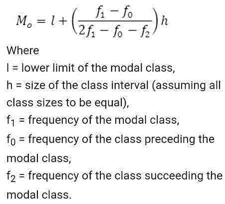
The histogram is the most useful to find the value of:

Detailed Solution for APSET Paper 2 Mock Test - 4 (Geography) - Question 4

The correct answer is Mode.

Key Points

  • HIstogram
    • A Histogram is an approximate representation of the distribution of numerical data.
    • It was first introduced by Karl Pearson.
    • Its purpose is to roughly assess the probability distribution of a given variable by depicting the frequencies of observations occurring in certain ranges of values.
    • Histograms are sometimes confused with bar charts.
    • It is used for continuous data, where the bins represent ranges of data while a bar chart is a plot of categorical variables.
  • Mode
    • Mode is the value that appears most often in a set of data values.
    • The mode is the way of expressing in a single number, important information about a random variable or a population.
    • For a systematic histogram, the values of mode are all the same and are all located at the center of the distribution, the mode always occurs at the highest point of the peak.

Additional Information

  • Arithmetic mean
    • Arithmetic mean is the mean or the average or the sum of a collection of numbers divided by the numbers in the collection.
    • The term Arithmetic mean is preferred in some contexts in mathematics and statistics, because it helps distinguish it from other means, such as the geometric mean and the harmonic mean.
    • It is the most commonly used and readily understood measure of central tendency in a data set.

  • Median
    • The median is the middle number in a sorted ascending or descending, list of numbers and can be more descriptive of that data set than the average.
    • The median is sometimes used as opposed to the mean when there are outliers in the sequence that might skew the average of the values.
    • The median is of central importance in robust statistics, as it is the most resistant statistic.

APSET Paper 2 Mock Test - 4 (Geography) - Question 5
Who is the author of The Geographical Tradition (1993)?
Detailed Solution for APSET Paper 2 Mock Test - 4 (Geography) - Question 5

Correct Answer: D.N. Livingstone.

Key Points

  • The quarter of a century since the publication of David Livingstone’s (1992) The Geographical Tradition provides an apt moment to reflect on the book’s theses, lacunae, and legacies, and to take stock of the ways in which its provocations and reception might instruct the wider project of rendering the discipline’s history.
  • In framing this themed intervention, we engage the assertion that contextualizers need contextualizing; there exists scope to heighten awareness of the location within time, space, and culture from which contextualist historiographies of geography are written. We call attention to the meaning and implications of the particular and situated contextualist methodology mobilized and executed in The Geographical Tradition.
  • The Geographical Tradition undoubtedly broke new ground in its relentless scrutiny of the reciprocal constitution of text and context and its sustained contextualist interrogation of geography, Geography, and geographers. For Withers, a key to The Geographical Tradition was Livingstone’s “insistence that we must situate geography historically and geographically”.
  • The four traditions are the Spatial or Locational Tradition, the Area Studies or Regional Tradition, the Man-Land Tradition, and the Earth Science Tradition. Each of these traditions is interrelated, and they are often used in conjunction with one another, rather than alone.

​ Additional Information

  • Livingstone detected two critical flaws in existing historiographical accounts: ‘presentism’ or interpreting past geographical ideas by the (scientific, moral, and aesthetic) standards of today, and ‘internalism’ or construing the evolution of the discipline in terms of interior drivers of change (scholarly fields, their champions, spats, alignments, and plays). Refusing to label and police the boundaries of his alternative approach too strictly, he invoked the simple yet powerful idea of 'situated messiness'.
APSET Paper 2 Mock Test - 4 (Geography) - Question 6
______ is an equatorial belt of low atmospheric pressure where the trade winds converge.
Detailed Solution for APSET Paper 2 Mock Test - 4 (Geography) - Question 6

The correct answer is Doldrums.

  • Doldrums is an equatorial belt of low atmospheric pressure where the trade winds converge.

Key Points

Moraine

  • Moraines are distinct ridges or mounds of debris that are directly laid down by a moving glacier. This material is usually soil and rock.
  • Moraines only show up in places that have, or used to have glaciers.
  • Glaciers are extremely large, moving rivers of ice.
  • Glaciers shape the landscape in a process called glaciation.
  • Glaciation can affect the land, rocks, and water in an area for thousands of years. That is why moraines are often very old.

La Nina

  • La Nina is a climate pattern that describes the cooling of surface ocean waters along the tropical west coast of South America.
  • La Nina is the counterpart of El Nino.
  • La Lina means Little Girl in Spanish.
  • La Lina occurs at irregular intervals of about two to seven years.
  • La Niña is caused by a build-up of cooler-than-normal waters in the tropical Pacific, the area of the Pacific Ocean between the Tropic of Cancer and the Tropic of Capricorn.
  • Unusually strong, eastward-moving trade winds and ocean currents bring this cold water to the surface, a process known as upwelling.

El Nino

  • El Nino is a climate pattern that describes the unusual warming of surface waters in the eastern tropical Pacific Ocean.
  • El Nino means Christ child or Littel Boy in Spanish
  • During the time of El Nino, the trade winds weaken and warm water pushed back east towards the coast of Latin American countries.
  • El Nino can affect our weather significantly and trade winds.
  • El Nino has a strong effect on marine life off the Pacific coast.

Additional Information

  • Atmospheric Pressure belts are seasonally identical horizontal pressure variations created in the earth's atmosphere just above the earth's surface due to seasonal and spatial variation of energy received by the earth at different places.
  • There are seven pressure belts on the earth's surface. They are the Equatorial Low, the two Subtropical highs, the two Subpolar lows, and the two Polar highs. Except for the Equatorial low, the others form matching pairs in the Northern and Southern Hemispheres.

Equatorial Low-Pressure Belts

  • It is located on either side of the North and South of the Equator in a zone extending from 0o to 5o.
  • It is thermally induced because of the intense heating of the ground by the vertical rays of the sun.
  • It represents the zone convergence of North-East and South-East trade winds. This convergence zone is characterized by light and feeble winds and because of the frequent calm conditions, this belt is also called a belt of calm or doldrums.

Subtropical High-Pressure Belts

  • It extends between 30o to 35o both the hemisphere
  • It is not thermally induced but dynamically induced as it owes its origin to the rotation of the earth and sinking and settling down of winds.
  • Here the zone convergence of winds at a higher altitude above this zone results in the subsidence of air from higher altitudes and this wind results in high pressure. This zone of high pressure is also called the Horse latitude.
  • The permanent winds blowing from the Sub-Polar High-Pressure to Sub-Polar Low-Pressure in both the hemisphere are called Westerlies.

Sub-Polar Low-Pressure Belts

  • It extends between 60o and 65o in both the hemisphere.
  • The low-pressure belt does not thermally induce because there is low temperature throughout the year and as such there should have been a high-pressure belt instead of low pressure.
  • Pressure gradient, rotation of the earth and Coriolis force, centrifugal action of wind are the factor that controls the air motion.
  • This region is marked by violent storms in winter.

Polar High-Pressure Belts

  • Polar high pressure is very small in area and extends between 70o to 90oin both the hemisphere.
  • The temperatures are always extremely low.
  • The Polar regions experience very cold climatic conditions due to the rays of the sun is extremely slanting.
  • These regions of Polar high-pressure belts are known as the Polar Highs.
  • These regions are characterized by permanent IceCaps.

APSET Paper 2 Mock Test - 4 (Geography) - Question 7
Western disturbances are extratropical storms that bring sudden winter rain to the northern parts of India. They originate in ______.
Detailed Solution for APSET Paper 2 Mock Test - 4 (Geography) - Question 7

The correct answer is the Mediterranean Sea.

Key PointsWestern disturbances are extratropical storms that bring sudden winter rain to the northern parts of India. They originate in the Mediterranean Sea

Western Disturbances

  • Western Disturbances form in the mid-latitude area, situated north of the Tropic of Cancer. This is why they are referred to as mid-latitude storms or extra-tropical storms
  • Western Disturbances are low-pressure systems, embedded in western winds (westerlies)  that flow from west to east.

Arrival in India

  • Western Disturbances begin is a low-pressure system that originates in the Mid-latitude region near the Atlantic Ocean and Europe.
  • The low pressure typically forms over the Mediterranean Sea and travels over Iran, Iraq,  Afghanistan, and Pakistan before entering India loaded with moisture.
  • These moisture-laden western disturbances eventually come up against the Himalayas and get blocked, as a consequence, the moisture gets trapped and precipitation is shared in the form of snow and rain over Northwest India and other parts of North India. 
  • An average of 4-5 western disturbances form during the winter season and the rainfall distribution and amount varies with every western disturbance.
  • The word 'Western' refers to the direction from which they originate in India.
  • The word 'disturbance' is used because the air within the low-pressure systems tends to be unstable or disturbed.
  • When western disturbances become more intense in the Indian Region, they can extend even up to 15 degrees north, resulting in rainfall up to north Maharashtra,  Gujarat, and the entire Madhya Pradesh to the south.

Impact

  • Western Disturbances are the cause of most winter and pre-monsoon season rainfall across North-West India.
  • This phenomenon is usually associated with a cloudy sky, higher night temperatures, and unusual rain.
  • It is estimated that India gets close to 5-10% of its total annual rainfall from western disturbances.
  • In winter, western winds bring moderate to heavy rain in low-lying areas and heavy snow to mountainous areas of the Indian subcontinent. 
  • India is a rain-dependent country and while the southwest monsoon covers most of India, parts of North India don’t get much rain from it.
  • These regions depend upon snow and rain from western disturbances during the winter season from November to March.
  • Precipitation during the winter season has great importance in agriculture particularly for rabi crops including wheat, which is one of the most important Indian crops.
  • They start declining after winter.
  • During the summer months of April and May, they move across North India and at times help in the activation of monsoon in certain parts of northwest India.
  • During the monsoon season, western disturbances may occasionally cause dense clouding and heavy precipitation.
  • Weak western disturbances are associated with crop failure and water problems across north India.
  • Strong western disturbances can help residents, farmers and governments avoid many of  the problems associated with water scarcity.

Additional Information

  • The Mediterranean Sea is located between Eurasia and Africa, mostly surrounded by land.
  • It shares borders with 21 countries: Albania, Algeria, Bosnia and Herzegovina, Croatia, Cyprus, Egypt, France, Greece, Israel, Italy, Lebanon, Libya, Malta, Monaco, Montenegro, Morocco, Slovenia, Spain, Syria, Tunisia, and Turkey.
  • To the west, it connects to the Atlantic Ocean via the Strait of Gibraltar.
  • To the east, it is linked to the Black Sea through the Dardanelles Straits.
  • To the south, it is connected to the Red Sea through the Suez Canal.
  • The Nile River in Africa drains into the Mediterranean Sea.

APSET Paper 2 Mock Test - 4 (Geography) - Question 8

Which type of settlement pattern is having the following features?

1. narrow meandering streets and lanes

2. high population density

3. the high degree of nucleation

4. most common in India

Select the correct answer using the code given below.

Detailed Solution for APSET Paper 2 Mock Test - 4 (Geography) - Question 8

The correct answer is a Rectangular pattern.

Key Points

Rectangular pattern: 

  • The settlements with rectangular patterns have a high degree of nucleation.
  • More than 50% of the world's population lives in such settlements.
  • This pattern of settlement is most common in India.
  • This pattern of settlement is found where the land capability is high
  • The areas having this pattern of settlement have a high degree of clustering and high population density.
  • The shape of the cultivated land is rectangular.
  • Examples (India)
    • Most North Indian villages have rectangular patterns dominated by caste groups.
    • Ganga-Yamuna-Doab, Eastern Uttar Pradesh villages, Western Bihar villages.
  • Regions with high population density like well-planned settlements of Germany, Russia, China, Israel, France, etc. (these are the places with planned settlements)
  • The settlements with rectangular patterns have narrow meandering streets and lanes.
  • In the central part, the village headman or old Zamindar house with his own caste man has greater nucleation while away from the centre spacing between house increases.
APSET Paper 2 Mock Test - 4 (Geography) - Question 9
Federalism does not involve which of the following?
Detailed Solution for APSET Paper 2 Mock Test - 4 (Geography) - Question 9

The correct answer is the Centralization of power.Important Points

  • Federalism is a system of government in which the same territory is controlled by two levels of government. Generally, an overarching national government is responsible for the broader governance of larger territorial areas, while the smaller subdivisions, states, and cities govern the issues of local concern. Both the national government and the smaller political subdivisions have the power to make laws and both have a certain level of autonomy from each other.

Key Points

  • Federalism the political system itself must reflect the constitution by actually diffusing power among several substantially self-sustaining centers. Such a diffusion of power may be termed noncentralization.
  • Noncentralization is a way of ensuring in practice that the authority to participate in exercising political power cannot be taken away from the general or the state governments without common consent.
  • The constituent polities in a federal system must be fairly equal in population and wealth or else balanced geographically or numerically in their inequalities.
  • Federalism is a combined or compound mode of government that combines a general government (the central or "federal" government) with regional governments (provincial, state, cantonal, territorial, or other sub-unit governments) in a single political system, dividing the powers between the two.
  • Federalism in the modern era was first adopted in the unions of states during the Old Swiss Confederacy.
  • Federalism differs from confederalism, in which the general level of government is subordinate to the regional level, and from devolution within a unitary state, in which the regional level of government is subordinate to the general level. It represents the central form in the pathway of regional integration or separation, bounded on the less integrated side by confederalism and on the more integrated side by devolution within a unitary state.
  • Examples of a federation or federal province or state include Argentina, Australia, Belgium, Bosnia & Herzegovina, Brazil, Canada, Germany, India, Iraq, Malaysia, Mexico, Micronesia, Nepal, Nigeria, Pakistan, Russia, Switzerland, the United Arab Emirates, and the United States.
APSET Paper 2 Mock Test - 4 (Geography) - Question 10
Which of the following is the correct description of a ‘Hydrological Drought’?
Detailed Solution for APSET Paper 2 Mock Test - 4 (Geography) - Question 10
The correct answer is Option 2.
Key Points
Drought
  • Drought refers to a situation when there is a shortage of water availability due to inadequate precipitation, excessive evaporation rate, over-utilisation of water from reservoirs etc.
  • It is the world’s most costly natural hazard which impacts very large areas compared to other disasters.
  • It leads to significant losses in the economy, ecology, and environment.
Types of Droughts:
  • Meteorological Drought:
    • It occurs when water shortages are caused by an imbalance in precipitation and evaporation. Hence, option 1 is incorrect.
  • Hydrological Drought:
    • A situation when there is inadequate surface and subsurface water in a water resource management systemHence, option 2 is correct.
  • Agricultural Drought:
    • A situation arises when there is inadequate soil moisture that is necessary to support the crops. Thus, it leads to crop failures and later food shortages. Hence, option 3 is incorrect.
  • Ecological Drought:
    • It occurs when the productivity of a natural ecosystem fails due to water shortages causing environmental distress. Hence, option 4 is incorrect.
APSET Paper 2 Mock Test - 4 (Geography) - Question 11

Match the following local storms with their correct definition:

I. Mango Shower -  A) Pre-Monsoon showers which help in blossoming of coffee flowers

II. Blossom Shower  -  B) Pre-Monsoon showers which help in the ripening of mangoes

III. Nor Westers - C) Hot, dry and oppressing winds blowing in Northern plains

IV. Loo - D) Evening thunderstorms in Bengal and Assam

Detailed Solution for APSET Paper 2 Mock Test - 4 (Geography) - Question 11

Answer: Option 2) IB, IIA, IIID, IVC.

Additional Information 

1. Mango Shower: 

  • Mango showers are pre-monsoon showers common in the states of Karnataka and Kerala in India.
  • These showers occur at the end of the summer season and help in the ripening of mangoes. 
  • Mango showers are also known as 'blossom showers' in some parts of India.

2. Blossom Shower:

  • Blossom showers are local storms or winds that help in the blossoming of coffee flowers.
  • These showers occur in the early spring season and are essential for the coffee crop.
  • Blossom showers are also known as 'cherry showers' in some parts of the world

3. Nor westers:

  • Nor westers are violent thunderstorms that occur in the Gangetic plains of India and Bangladesh.
  • These storms are characterized by strong winds, heavy rain, and lightning.
  • Nor westers can cause significant damage to crops and infrastructure.
  • They occur during the pre-monsoon season (March-May) and are often associated with squall lines.

4. Loo:

  • Loo is a strong, dry, and hot wind that blows in the northern plains of India and Pakistan.
  • Loo winds are common during the summer season (April-June) and can cause heatstroke and other health problems.
  • These winds can also cause significant damage to crops and vegetation.
  • Loo winds are also known as 'hot winds' or 'dust storms' in some parts of the world.

Hence, the correct answer is: Option 2) IB, IIA, IIID, IVC

APSET Paper 2 Mock Test - 4 (Geography) - Question 12

Given below are some human activities:

A. Digging of mines

B. Constructing dams

C. Collection of leaves and herbs to sell them in the market

D. Weaving baskets from bamboo

E. Making leaf plates out of fallen leaves.

Which of the following statements are responsible for the disappearance of forests ?

Detailed Solution for APSET Paper 2 Mock Test - 4 (Geography) - Question 12

Option 2 is the correct answer: Activities mentioned in A and B statements are responsible for the disappearance of forests.

  • Digging of Mines: Some of the mineral ores are located in the forest areas or under tree cover. In order to extract them out, the land is cleared for mining by cutting down the trees. Therefore mining leads to the disappearance of forests.
  • Dam constructions: A large mountainous area covered with trees are submerged under reservoir water after dam construction leading to the disappearance of forests.
  • The activities mentioned in C, D and E although derive the raw material from forests but they don’t lead to the disappearance of forest. For the proper and continuous supply of these raw materials from forests, these activities promote forest conservation instead.

India State of Forest Report  (ISFR) 2019:

  • It is a biennial report published by the Forest Survey of India (FSI).
  • The first report was released in 1987 and the ISFR 2019 report was the 16th report in the series.
  • According to it the total tree and forest cover in India is 24.56% of its total geographical area.
  • Madhya Pradesh, Arunachal Pradesh and Chhattisgarh are the top rankers in terms of area wise forest cover.
  • Mizoram, Arunachal Pradesh and Meghalaya have the highest percentage-wise forest cover area.
APSET Paper 2 Mock Test - 4 (Geography) - Question 13
Which of the following is the correct statement regarding demographic dividend?
Detailed Solution for APSET Paper 2 Mock Test - 4 (Geography) - Question 13

The correct answer is Only 1.

Key Points

  • According to United Nations Population Fund (UNFPA), demographic dividend means, "the economic growth potential that can result from shifts in a population’s age structure, when the working-age population (15 to 64) is larger than the non-working-age of the population (14 and younger, and 65 and older)".
  • With fewer births each year, a country’s working-age population grows larger relative to the young dependent population.
  • India has one of the youngest populations in an aging world.
APSET Paper 2 Mock Test - 4 (Geography) - Question 14

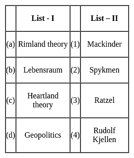
Match the concepts (List - I) with their proponents (List - II) selecting correct answer from the codes given below :
Detailed Solution for APSET Paper 2 Mock Test - 4 (Geography) - Question 14

The correct answer is (a) - (2), (b) - (3), (c) - (1), (d) - (4)

Key Points

  • Heartland theory was given by British political geographer H J Mackinder in the year 1904. "The Geographical Pivot of History" is an article submitted by Halford John Mackinder in 1904 to the Royal Geographical Society that advances his heartland theory. In this article, Mackinder extended the scope of geopolitical analysis to encompass the entire globe.
  • Heartland theory believed that whoever controls the heartland( Siberia and part of central Asia) will control the world islands whereas rimland theory believed that whoever controls the rimland (Inner marginal crescent) comprised Europe, North Africa, West Asia, India, South East Asia, and part of China will control the world islands
  • Spykeman propounded the Rimland theory in opposition to the Heartland theory of Mackinder. Spykman proposed a theory that countered Mackinder's Heartland Theory. According to his rimland theory, the coastal areas or littorals of Eurasia are key to controlling the World Island, not the Heartland. As per Spykman, landlocked states usually faced security challenges from their immediate neighbors.
  • The ideology of Nazism Party workers and also Adolf Hitler was Lebensraum which meant that the living space or territory area extended to enable the material resources and the power of the German Nation and also established the new territory for their people settlement.
  • The term Lebensraum was coined by the German geographer, Friedrich Ratzel (1844-1904). During the last two decades of the 19th century, Ratzel developed a theory according to which the development of all species, including humans, is primarily determined by their adaptation to geographic circumstances.
  • Geopolitics, analysis of the geographic influences on power relationships in international relations.
  • The word geopolitics was originally coined by the Swedish political scientist Rudolf Kjellén about the turn of the 20th century, and its use spread throughout Europe in the period between World Wars I and II (1918–39) and came into worldwide use during the latter.
APSET Paper 2 Mock Test - 4 (Geography) - Question 15

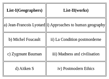
Match List-I with List-II and select the correct answer from the codes given below :
Choose the correct option from below:

Detailed Solution for APSET Paper 2 Mock Test - 4 (Geography) - Question 15

Post modernism is an approach in human geography. It is against the concept of modernism and rejects all the statements the theory gives.

La condition postmorderne was the work of Jean Francois Lyotard.

Madness and civilization is the work of Michel Foucalt.

Postmodern Ethics is the work of Zygmunt Bauman.

Approaches to human geography is the work of Aitken S.

APSET Paper 2 Mock Test - 4 (Geography) - Question 16

Match List-I with List-II and select the correct answer from the codes given below :
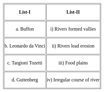
Choose the correct option from below:

Detailed Solution for APSET Paper 2 Mock Test - 4 (Geography) - Question 16


Leonardo da Vinci believed the rivers formed their vallies themselves through vertical erosion. Buffon opined that the rivers were the most powerful agent of erosion.

Targioni Tozetti stated that the rivers depend on the nature of the rocks through which they flow.

Guttenberg opined that not all the sediments eroded are deposited by the river in the sea rather some parts are also deposited in the course of river as the flood plain.

Thus, the Correct answer is B.


APSET Paper 2 Mock Test - 4 (Geography) - Question 17

Which of the following pairs of "Ocean- Maximum Deepest Point" is correct?

1. Pacific Ocean - Mariana Trench

2. Indian Ocean - Sunda Trench

Detailed Solution for APSET Paper 2 Mock Test - 4 (Geography) - Question 17

The correct answer is Both 1 and 2.

Key Points

Mariana Trench:

  • The Mariana Trench is located in the western Pacific Ocean and has the deepest natural trench in the world.
  • It is a crescent-shaped trough in the Earth's crust averaging about 2,550 km long and 69 km wide.
  • The maximum known depth is 10,994 meters at the southern end of a small slot-shaped valley on its floor known as the Challenger Deep.

Sunda Trench:

  • The Sunda Trench, earlier known as and sometimes still indicated as the Java Trench, is an oceanic trench located in the Indian Ocean near Sumatra.
  • It is located in the Indian Ocean.
APSET Paper 2 Mock Test - 4 (Geography) - Question 18
Who postulated the paving stone hypothesis?
Detailed Solution for APSET Paper 2 Mock Test - 4 (Geography) - Question 18

The term plate was first used by J.T. Wilson in 1965. McKenzie and Parker elaborated the mechanism behind the movement of plates in 1967. It was based on Euler’s geometrical theorem. Based on this, they gave the paving stone hypothesis. It says that oceanic crust is formed at the ridges and destroyed at the trenches. Isacks and Sykes confirmed this hypothesis in 1967.

Thus, the Correct answer is B.

APSET Paper 2 Mock Test - 4 (Geography) - Question 19

Choose the correct statement from below:

Statement I:The concentration of the economy in the core city begins as a result of innovation. capital accumulation and industrial growth.

Statement II: The pre-industrial (agricultural) society, with localized economies and a small-scale settlement structure.

Detailed Solution for APSET Paper 2 Mock Test - 4 (Geography) - Question 19

The correct answer is Both Statement I & Statement II are true.
Key Points

Both statements are taken from Core-periphery model of economic development.

  • This model was developed in 1963 by John Friedmann.
  • It is a model of the spatial organization of human activity based upon the equal distribution of power in the economy and society.

Stage 1 (Pre-industrial)

  • The pre-industrial (agricultural) society, with localized economies and a small-scale settlement structure.
  • Each settlement is fairly isolated, activities are dispersed and mobility is low.
  • There are limited differences between spatial entities in terms of levels of economic development

 Hence ,Statement I is true.

Stage 2 (Transitional)

  • The concentration of the economy in the core city begins as a result of innovation. capital accumulation and industrial growth.
  • The specific reasons behind this concentration are often not too clear, location (better access) being a significant factor, but the fact remains that a dominant centre emerges within an urban system to become its growth pole.
  • Trade and mobility increase, but within a pattern dominated by the core even if the overall mobility remained low.

 Hence ,Statement II is true.
Additional Information
Stage 3 (Industrial

  • Through a process of economic growth and diffusion, other growth centres emerge.
  • The main reasons for deconcentration are increasing input costs (mainly labor and land) in the core area.

Stage 4 (Post-industrial)

  • The urban system becomes fully integrated and spatial inequalities are reduced significantly.
  • The distribution of economic activities creates a specialization and a division of labor linked with intense flows along high-capacity transport corridors.

APSET Paper 2 Mock Test - 4 (Geography) - Question 20

Consider statements (A) and (B) and choose the correct option.

(A) The coastline of Indian ocean is identical and irregular.

(B) The indented and irregular coastline provides ideal location for natural harbours and ports.

Detailed Solution for APSET Paper 2 Mock Test - 4 (Geography) - Question 20

The correct answer is that (A) is false and (B) is true.

Key Points

  • A coastline is a line that forms the boundary between the land and the ocean.
  • The intended and irregular coastline provides an ideal location for natural harbours and ports.
  • The coastline of the Atlantic ocean is identical and irregular.
  • The Atlantic Ocean is the second largest ocean in the world.
  • The intended coastline helps in two ways:
    • provides natural sideways protection for the ships if they harbour there
    • less cost is incurred due to its shape

Thus, we can say that the intended and irregular coastline provides an ideal location for natural harbours and ports.

APSET Paper 2 Mock Test - 4 (Geography) - Question 21

Which of the following is/are the ideal conditions for temperature inversion to occur?

A. Cloudy skies

B. Calm and stable air

C. Long summer days

Select the correct answer using the codes given below:

Detailed Solution for APSET Paper 2 Mock Test - 4 (Geography) - Question 21

The correct answer is B only.

Key Points

  • The Ideal conditions for temperature inversion are:
    • Long hours, so that it is greater than the incoming radiation than the outgoing radiation.
    • Clear skies that allow radiation to escape unhindered.
    • Calm and stable air, such that, at lower speeds, there is no vertical mixing.
  • A temperature inversion is the reversal of the natural temperature activity in the troposphere, where a layer of cool air on the surface is replaced by a layer of warmer air. (The temperature normally decreases with height under normal conditions).

Additional Information

  • An inversion serves as a limit on the airflow from the layers below upwards. As a consequence, the convection produced by air heating from below is limited to levels below the inversion stage.
  • Likewise, the diffusion of dust, smoke, and other air contaminants is reduced.
  • Convective clouds do not rise high enough to create showers in regions where a pronounced low-level inversion is present.
  • Owing to the accumulation of dust and smoke particles, visibility can be significantly diminished under the inversion. Since the air at the base of inversion appears to be cold, there is sometimes fog.
APSET Paper 2 Mock Test - 4 (Geography) - Question 22

Mark the correct order of pressure belts from the equator to the poles:

A. Equatorial Low Belt

B. Subtropical High Belt

C. Sub-polar Low Belt

D. Polar High Belt

Select the correct answer from the options given below:

Detailed Solution for APSET Paper 2 Mock Test - 4 (Geography) - Question 22

The correct answer is A, B, C, D.

  • The correct order of Pressure belts from the equator to the poles is Equatorial Low Belt, Subtropical High Belt, Sub-polar Low Belt, Polar High Belt.
  • Subtropical high-pressure belt:
    • It extends from the tropics to about 350 latitudes in both the hemispheres.
    • The ascending air of the equatorial region is deflected towards the poles due to the earth's rotation.
    • After becoming cold and heavy, the air descends in these regions and gets piled up, which results in high pressure.
    • This zone is characterized by anti-cyclonic conditions, which lead to atmospheric stability and aridity.
    • Wind in this zone is known as tropical easterlies i.e northeast trade winds in the northern hemisphere and southeast trade winds in the southern hemisphere.
  • ​Equatorial low-pressure belt:
    • This belt extends from the equator to 100 N and 100 S latitudes.
    • The intertropical convergence zone (ITCZ) is known as the region of convergence near the equator because the winds flowing from subtropical high-pressure belts converge here.
    • This low-pressure belt is also known as doldrums because it is a zone of total calm without any winds.
    • Due to high temperatures, a low-pressure belt is created in the equatorial region.
    • This gives rise to air convergence in the area.
  • Sub Polar Low-Pressure Belts:
    • They extend between 450 N and 700N in the northern hemisphere and between 450 S and 700 N in the southern hemisphere.
    • Winds coming from the subtropical and the polar high belts converge here to produce cyclonic storms or low-pressure conditions due to the formation of fronts.
    • This zone of convergence is also known as the polar front. This region is marked by violent storms in winter.
    • The winds developed in this region are called westerlies.
    • Depending on the latitudes, Westerlies are also known as Roaring Forties, Furious Fifties, and Shrieking Sixties.
  • The polar high-pressure belt is located between 85°N to 90°N and 85°S to 90°S.

APSET Paper 2 Mock Test - 4 (Geography) - Question 23
El Nino originates in
Detailed Solution for APSET Paper 2 Mock Test - 4 (Geography) - Question 23

El Nino means Little Boy. It refers to warm ocean current which originates in the central and east-central Pacific, including area of pacific coast of South America. The phenomenon has effects on global climate.

Thus, the correct answer is B.

APSET Paper 2 Mock Test - 4 (Geography) - Question 24
Drought Prone Area Programme was initiated during which five year plan in India? 
Detailed Solution for APSET Paper 2 Mock Test - 4 (Geography) - Question 24

The correct answer is Fifth five year plan in India.
Key Points

  1. The Drought Prone Area Programme (DPAP) was launched in India in 1973-74  in Fifth Five year Plan as a centrally sponsored scheme to provide relief to the regions affected by droughts.

  2. The programme was initiated with the objective of providing employment opportunities and means of livelihood to the people living in the drought-prone areas.

  3. The programme was implemented in 107 districts of the country, covering around 23% of the total geographical area.

  4. The programme aimed to develop land and water resources, increase agricultural productivity, and promote sustainable development in the drought-prone areas.

  5. Under the programme, various activities were undertaken, including soil conservation, afforestation, water harvesting, construction of check dams, and provision of drought-resistant seeds.

  6. The DPAP was merged with the Integrated Watershed Development Programme (IWDP) in 1999, which aimed at sustainable development of natural resources and poverty alleviation in the areas prone to drought and floods.

  7. The IWDP programme has now been subsumed under the Pradhan Mantri Krishi Sinchai Yojana (PMKSY) and the National Rural Employment Guarantee Act (NREGA).

  8. The DPAP played a significant role in mitigating the effects of droughts in the country and helped in improving the socio-economic conditions of the people living in the drought-prone areas

APSET Paper 2 Mock Test - 4 (Geography) - Question 25

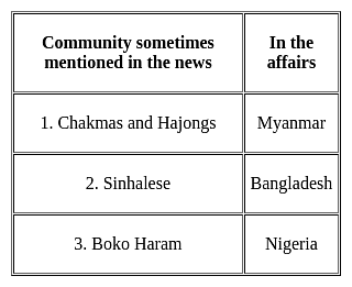
Consider the following pairs :

Which of the pairs given above is/are correctly matched?

Detailed Solution for APSET Paper 2 Mock Test - 4 (Geography) - Question 25

The correct answer is 3 only.

Key Points

Boko Haram

  • It is the militant group in northern Nigeria that has killed tens of thousands of people and displaced more than 3 million people. Hence, Pair 3 is correctly matched.
  • Boko Haram militants mainly inhabit areas in the northern states of Nigeria, specifically Yobe, Kano, Bauchi, Borno and Kaduna.
  • Boko Haram means "Western education is forbidden." The group was founded in 2002.

Sinhalese

  • It is also spelt Singhalese or Cingalese, a member of the people of Sri Lanka (formerly Ceylon) who constitute the largest ethnic group on that island. Hence, Pair 2 is not correctly matched.
  • In the early 21st century the Sinhalese were estimated to number about 13.8 million, or 73 per cent of the population.
  • Their ancestors are believed to have come from northern India, traditionally in the 5th century BCE.
  • Their language belongs to the Indo-European family.

Chakmas and Hajongs

  • The Chakmas and Hajongs of Arunachal Pradesh are migrants from the Chittagong Hill Tracts of erstwhile East Pakistan, now Bangladesh. Hence, Pair 1 is not correctly matched.
  • Displaced by the Kaptai dam on the Karnaphuli River in the 1960s, they sought asylum in India.
  • They settled in relief camps in the southern and south-eastern parts of Arunachal Pradesh from 1964 to 1969.
  • A majority of them live in the Changlang district of the State today.
  • Mizoram and Tripura have a sizeable population of the Buddhist Chakmas while the Hindu Hajongs mostly inhabit the Garo Hills of Meghalaya and adjoining areas of Assam.
APSET Paper 2 Mock Test - 4 (Geography) - Question 26

The earliest arrivals in India are believed to be Negritos. At which one of the following places are they mainly found now?

Detailed Solution for APSET Paper 2 Mock Test - 4 (Geography) - Question 26

The earliest arrivals in India are believed to be Negritos. At Andaman Islands they are mainly found now. The Andaman Islands are home to four 'Negrito' tribes – the Great Andamanese, Onge, Jarawa and Sentinelese. The Nicobar Islands are home to two 'Mongoloid' tribes – the Shompen and Nicobarese. The 'Negrito' tribes are believed to have arrived in the islands from Africa up to 60,000 years ago.

APSET Paper 2 Mock Test - 4 (Geography) - Question 27

Which one of the following industries would be found in the traditional industrial region?

Detailed Solution for APSET Paper 2 Mock Test - 4 (Geography) - Question 27

Industries like Cotton Textile Industries, Iron and Steel industries, Sugar industries are characterized by higher proportion of workers in semi-skilled categories, using old obsolete technology, causing huge pollution unlike modern high tech industries. IT industries and the knowledge-based industries do not fall under traditional large-scale industries.

APSET Paper 2 Mock Test - 4 (Geography) - Question 28

Match List-I with List-II and select the correct answer using the codes given below the lists:
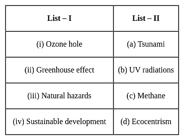
Detailed Solution for APSET Paper 2 Mock Test - 4 (Geography) - Question 28

Key Points


Therefore, the correct answer is Option 1.

APSET Paper 2 Mock Test - 4 (Geography) - Question 29

Which of the following is world's second largest producer of palm oil after Indonesia?

Detailed Solution for APSET Paper 2 Mock Test - 4 (Geography) - Question 29

The correct answer is Malaysia.

Key Points

  • Malaysia is the world's second-largest producer of palm oil after Indonesia.
  • Malaysia's palm oil inventory production has surged and coronavirus lockdowns led to a slump in demand.
    • Thus, Malaysian palm oil is available at a discount price compared to supplies from Indonesia.
    • On the other hand, Indonesia has also raised its palm oil export levy.
  • Additionally, Malaysia has also signed a deal to buy 100,000 tonnes of Indian rice.​

Additional Information

  • India's Palm Oil import:
    • India is the world’s biggest buyer of edible oils.
    • India buys more than two-thirds of its total edible oil imports as palm oil.
  • India-Malaysia Relation
    • India established diplomatic relations with Malaysia in 1957.
    • Economic Relation:
      • India and Malaysia have signed the Comprehensive Economic Cooperation Agreement (CECA).
      • CECA is a kind of Free Trade Agreement (FTA).
        • India has also signed the Free Trade Agreement (FTA) in services and investments with the 10-member Association of Southeast Asian Nations (ASEAN).
        • Malaysia is the third-largest trading partner in ASEAN.
    • Bilateral trade between India and Malaysia is significantly biased in favor of Malaysia.
    • Defence & Security Cooperation:
      • Joint military exercises “Harimau Shakti” are held annually between the two countries.
    • Traditional medicine:
      • India and Malaysia have signed an MoU on cooperation in the field of Traditional Medicine in October 2010.
APSET Paper 2 Mock Test - 4 (Geography) - Question 30
Which factor of globalization has largest share in spreading out production of services recent days?
Detailed Solution for APSET Paper 2 Mock Test - 4 (Geography) - Question 30

Information and communication technology is the factor of globalization has largest share in spreading out production of services recent days.

Important Points

  • Rapid improvement in technology has been one major factor that has stimulated the globalisation process.
  • Even more remarkable have been the developments in information and communication technology.
  • In recent times, technology in the areas of telecommunications, computers, Internet has been changing rapidly.
  • Telecommunication facilities (telegraph, telephone including mobile phones, fax) are used to contact one another around the world, to access information instantly, and to communicate from remote areas.

Information and communication technology (or IT in short) has played a major role in spreading out production of services across countries.

View more questions
60 tests
Information about APSET Paper 2 Mock Test - 4 (Geography) Page
In this test you can find the Exam questions for APSET Paper 2 Mock Test - 4 (Geography) solved & explained in the simplest way possible. Besides giving Questions and answers for APSET Paper 2 Mock Test - 4 (Geography), EduRev gives you an ample number of Online tests for practice

Top Courses for AP TET

Download as PDF

Top Courses for AP TET