AP TET Exam  >  AP TET Tests  >  APSET Mock Test Series 2025  >  APSET Paper 2 Mock Test - 1 (Geography) - AP TET MCQ

APSET Paper 2 Mock Test - 1 (Geography) - AP TET MCQ


Test Description

30 Questions MCQ Test APSET Mock Test Series 2025 - APSET Paper 2 Mock Test - 1 (Geography)

APSET Paper 2 Mock Test - 1 (Geography) for AP TET 2024 is part of APSET Mock Test Series 2025 preparation. The APSET Paper 2 Mock Test - 1 (Geography) questions and answers have been prepared according to the AP TET exam syllabus.The APSET Paper 2 Mock Test - 1 (Geography) MCQs are made for AP TET 2024 Exam. Find important definitions, questions, notes, meanings, examples, exercises, MCQs and online tests for APSET Paper 2 Mock Test - 1 (Geography) below.
Solutions of APSET Paper 2 Mock Test - 1 (Geography) questions in English are available as part of our APSET Mock Test Series 2025 for AP TET & APSET Paper 2 Mock Test - 1 (Geography) solutions in Hindi for APSET Mock Test Series 2025 course. Download more important topics, notes, lectures and mock test series for AP TET Exam by signing up for free. Attempt APSET Paper 2 Mock Test - 1 (Geography) | 100 questions in 120 minutes | Mock test for AP TET preparation | Free important questions MCQ to study APSET Mock Test Series 2025 for AP TET Exam | Download free PDF with solutions
APSET Paper 2 Mock Test - 1 (Geography) - Question 1

Which of the following are evidences of Continent Drift Theory?

Detailed Solution for APSET Paper 2 Mock Test - 1 (Geography) - Question 1

The correct answer is All of the Above.

Key Points

Evidence that supports the theory:

  • The Matching of Continents (Jig-Saw-Fit): 
    • The shorelines of Africa and South America facing each other match remarkably.
  • Rocks of Same Age Across the Oceans: 
    • Radiometric dating methods have correlated the rock formation in different continents.
  • Tillite: 
    • The glacial tillite found in the Gondwana system of sediments has its resemblance to six different landmasses of the Southern Hemisphere.
  • Placer Deposits: 
    • The placer deposits of gold in the Ghana coast do not have source rock in the region. 
    • The gold deposits of Ghana have been derived from the Brazil plateau when the two continents lay side by side
  • Distribution of Fossils: 
    • Identical species of plants and animals adapted to living on land or in freshwater are found on either side of the marine barriers.

Important Points

Continental Drift Theory:

  • Alfred Wegener put forward a continental drift theory in 1912.  
  • All the continents are formed of a single Continental mass and a mega ocean surrounded the same.
  • The supercontinent was named Pangaea and the Mega Ocean was called Panthalassa.  
  • Pangea first broke into two large Continental masses Laurasia and  Gondwanaland Forming the northern and Southern components respectively. 
  • Laurasia and Gondwanaland continued to break into smaller continents that existed today.  ​
APSET Paper 2 Mock Test - 1 (Geography) - Question 2

At what plate boundary setting is the ocean floor deepest?

Detailed Solution for APSET Paper 2 Mock Test - 1 (Geography) - Question 2

Answer: Option 2) Subduction.

The Earth's lithosphere is divided into tectonic plates that interact with one another at plate boundaries, influencing the topography of the ocean floor. The subsequent question delves into the characteristics of different plate boundary settings and seeks to identify the setting where the ocean floor is the deepest.

Key Points

  • The ocean floor is deepest at subduction zones.
  • Subduction zones occur at convergent plate boundaries, where one tectonic plate is forced beneath another.
  • This process results in the formation of deep ocean trenches, such as the Mariana Trench in the western Pacific, which is known as the deepest point on Earth's ocean floor.
  • The subduction of oceanic plates beneath continental plates or another oceanic plate creates a trench-like depression.

 Additional Information

  • Divergent: At divergent plate boundaries, tectonic plates move away from each other, creating mid-ocean ridges. While these ridges can be elevated, they are not associated with the deepest parts of the ocean floor.
  • Continent - Continent Collision: Continent-continent collisions result in the formation of large mountain ranges, such as the Himalayas. While this setting can lead to significant topographical features, it does not create the deepest parts of the ocean floor.
  • Transform: Transform plate boundaries involve plates sliding past each other horizontally. They are associated with features like strike-slip faults but do not typically result in the creation of deep ocean trenches.

Hence, the ocean floor is deepest at subduction zones.

1 Crore+ students have signed up on EduRev. Have you? Download the App
APSET Paper 2 Mock Test - 1 (Geography) - Question 3

What is a significant reason for the formation of submarine canyons on the continental shelf?

Detailed Solution for APSET Paper 2 Mock Test - 1 (Geography) - Question 3

Key Points

  • Submarine canyons, fascinating features on continental shelves, are the focus of the next question.
  • Understanding the forces that shape these canyons provides insights into the dynamic processes occurring beneath the ocean's surface.
  • A significant reason for the formation of submarine canyons on the continental shelf is Underwater landslides.
  • The underwater landslides can dislodge sediments collected on the continental shelves during storms or earthquakes.
  • The force of these moving sediments erodes the slopes as they come down, resulting in the carving out of submarine canyons. 

Additional Information 

Volcanic activity: While volcanic activity can shape the ocean floor, submarine canyons are more directly associated with the erosional processes linked to underwater landslides.

Coral reef growth: Coral reefs are formations built by living organisms and are not directly related to the creation of submarine canyons.

Glacial deposits: Glacial deposits may influence geological features in polar or glaciated regions, but the primary mechanism for submarine canyon formation is underwater landslides.

Hence,  the significant force contributing to the formation of submarine canyons on the continental shelf is c) Underwater landslides.

APSET Paper 2 Mock Test - 1 (Geography) - Question 4

What is the shallow submerged extension of a continent called?

Detailed Solution for APSET Paper 2 Mock Test - 1 (Geography) - Question 4

Answer: Option 3) continental Shelf.

The Earth's surface exhibits a fascinating interplay between land and water, and one notable feature is the transition between continents and oceans. Unlike a clear and defined separation, continents gradually slope seaward from the coast. This slope leads to the formation of a shallow submerged extension of the continent, a geographical feature of great importance. The upcoming question explores the terminology associated with this submerged extension.

Key Points

  • The shallow submerged extension of a continent is termed the Continental Shelf.
  • This region, varying in width and depth, represents the subaquatic continuation of the continent's landmass. 
  • the depth of the shallow seawater over the continental shelf ranges between 120 to 370 meters, and its width can vary significantly, extending from a few kilometers to over 100 kilometers.
  • The variations in continental shelf characteristics are observable globally, as evidenced by the differences between the eastern and western coasts of the Indian Peninsula, or the distinctions along the coasts of West Europe and Florida. 

Additional Information 

Oceanic Trench: An oceanic trench is a completely different geological feature compared to the continental shelf. Trenches are deep, elongated cavities in the ocean floor, typically formed by the subduction of tectonic plates. These are the deepest parts of the ocean and are quite distinct from the shallow, submerged extension of continents.

Continental Divide: The Continental Divide refers to a ridge along mountainous terrain that separates waters flowing into different oceans or river systems. It marks the boundary where rainfall or melting snowmelt may flow into different drainage basins. This term is more associated with the direction of water flow on the Earth's surface, rather than the physical extension of continents into the ocean.

Abyssal Plain: Abyssal plains are vast, flat expanses on the ocean floor that lie in the abyssal zone, typically at depths exceeding 4,000 meters. These plains are characterized by sediment deposition and are far deeper than the continental shelf. They are quite different from the shallower regions associated with the continental shelf.

hence, the term for the shallow submerged extension of a continent, where continents gently meet the oceanic expanse, is the Continental Shelf (Option c).

APSET Paper 2 Mock Test - 1 (Geography) - Question 5
Which one of the following climates are found in the coastal areas of California in North America, Chile in the middle of South America, and the southwest end of Western Australia?
Detailed Solution for APSET Paper 2 Mock Test - 1 (Geography) - Question 5

The Correct Answer is the Mediterranean.

Key Points

  • Mediterranean climates are found in coastal areas of California in North America, Central Chile in South America, and the South-West tip of West Australia. Winter precipitation is primarily the result of cold fronts that move across the Pacific Northwest and northern California.
  • The monthly average temperature in summer is around 25°C and in winter below 10°C.
  • The annual precipitation ranges from 35 - 90 cm.

Additional Information

  • Tropical savanna
    • A tropical wet and dry climate predominates in areas covered by savanna growth.
    • Mean monthly temperatures are at or above 64° F and annual precipitation averages between 30 and 50 inches.
    • For at least five months of the year, during the dry season, less than 4 inches a month are received.

  • humid continental climate
    • A humid continental climate is a climatic region defined by Russo-German climatologist Wladimir Köppen in 1900, typified by four distinct seasons and large seasonal temperature differences, with warm to hot summers and freezing cold winters.
  • Low latitude step
    • There are four low-latitude climates: wet equatorial, monsoon, and trade-wind coastal, wet-dry tropical, and dry tropical.
APSET Paper 2 Mock Test - 1 (Geography) - Question 6

Which among the following is the largest Bay of the world?

Detailed Solution for APSET Paper 2 Mock Test - 1 (Geography) - Question 6

Bay of Bengal is the largest bay in the world. It is located to southeast of India. The Hudson bay comes second.

APSET Paper 2 Mock Test - 1 (Geography) - Question 7

As per the Census 2011, which state has the lowest population in India?

Detailed Solution for APSET Paper 2 Mock Test - 1 (Geography) - Question 7

As per the Census of 2011 the population of Sikkim is 619,000 which is lowest in India. Sikkim is located at trijunction of India with China (Tibet), Nepal and Bhutan.

APSET Paper 2 Mock Test - 1 (Geography) - Question 8

As the temperature of the black body increases,the dominant wavelength of the emitted radiation according to Wein's displacement law is:

Detailed Solution for APSET Paper 2 Mock Test - 1 (Geography) - Question 8

According to Wein's displacement law:

Where A = Wein’s constant =2.898 x 10⁻³ mk

T = Temperature of the body

So, as the temperature of the black body increases, the dominant wavelength of the emitted radiation shifts towards shorter wavelength.

APSET Paper 2 Mock Test - 1 (Geography) - Question 9
Which of the following is an erosional landform?
Detailed Solution for APSET Paper 2 Mock Test - 1 (Geography) - Question 9

The yardangs is an Aeolian landform. It is formed when rock is eroded forming ridges and furrows alternately in the direction of the wind. Turkistan and Mojave deserts have quite a number of yardangs.

Thus, the Correct answer is C.

APSET Paper 2 Mock Test - 1 (Geography) - Question 10

Which of the following is true about Tropical Rain forest?

(A) These forest are called evergreen forests.

(B) The trees in these forests shed their leaves at different times of the year.

(C) Sal, Teak and Shisham are important trees of these forests.

(D) These forests are called monsoon forests.

Choose the correct option

Detailed Solution for APSET Paper 2 Mock Test - 1 (Geography) - Question 10

The correct answer for the given question is option 1, which includes options (A) and (B).

Key Points

  • Tropical rainforests are called evergreen forests because they have high annual rainfall and consistent temperature, which allows the trees to retain their leaves throughout the year.
  • The trees in tropical rainforests do not shed their leaves at the same time, but rather at different times of the year, which is known as deciduousness.
  • Sal, Teak, and Shisham are not important trees in tropical rainforests. These trees are commonly found in dry deciduous forests and savannas.
  • Tropical rainforests are not called monsoon forests. Monsoon forests are a type of tropical seasonal forest that experiences a distinct wet and dry season.

Additional Information

Additional information about the other options mentioned in the question are: - Option 2, which includes options (A) and (C), is incorrect because Sal, Teak, and Shisham are not important trees in tropical rainforests. - Option 3, which includes options (B) and (D), is incorrect because tropical rainforests are not called monsoon forests. - Option 4, which includes options (C) and (D), is incorrect because Sal, Teak, and Shisham are not important trees in tropical rainforests and tropical rainforests are not called monsoon forests. Key points for the correct options are: - Tropical rainforests are called evergreen forests because they have high annual rainfall and consistent temperature. - The trees in tropical rainforests do not shed their leaves at the same time, but rather at different times of the year. - Tropical rainforests are characterized by high biodiversity and complex ecosystems. - Tropical rainforests are vital for regulating the global climate and providing ecosystem services such as carbon storage, water cycling, and habitat for wildlife.

APSET Paper 2 Mock Test - 1 (Geography) - Question 11

Which among the following is / are correct statements with respect to Shifting Cultivation as practiced in India?

  1. India’s largest area under shifting cultivation is in the state of Arunachal Pradesh
  2. In recent years, the cycle of shifting cultivation on a particular land has reduced drastically

Select the correct option from the codes given below:

Detailed Solution for APSET Paper 2 Mock Test - 1 (Geography) - Question 11

The current practice of shifting cultivation in the eastern and north-eastern regions of India is an extravagant and unscientific form of land use. According to a recent estimate, India’s 0.59 percent of the total geographical area is under shifting cultivation. The effects of shifting cultivation are devastating and far-reaching in degrading the environment and ecology of these regions. The earlier 15–20 years cycle of shifting cultivation on a particular land has reduced to two or three years now. This has resulted in large-scale deforestation, soil and nutrient loss, and invasion by weeds and other species. The indigenous biodiversity has been affected to a large extent. The current statistics say that India’s largest area under shifting cultivation is in the state of Odisha.

APSET Paper 2 Mock Test - 1 (Geography) - Question 12
Which of the following rocks is formed when the molten magma cools down and becomes solid?
Detailed Solution for APSET Paper 2 Mock Test - 1 (Geography) - Question 12

The correct answer is Igneous Rock.Key Points

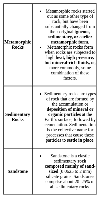
  • Igneous rock, or magmatic rock, is one of the three main rock types, the others being sedimentary and metamorphic.
  • Igneous rock is formed through the cooling and solidification of magma or lava.
  • The magma can be derived from partial melts of existing rocks in either a planet's mantle or crust.

Additional Information 

APSET Paper 2 Mock Test - 1 (Geography) - Question 13
Harmattan' warm and dry wind is a local wind found in
Detailed Solution for APSET Paper 2 Mock Test - 1 (Geography) - Question 13

The correct answer is the Sahara desert of Africa.

Key Points

  • Harmattan wind
    • It is found over the Sahara desert of Africa during summer.
    • It changes warm and moisture climatic conditions of the western coast of Africa into warm and dry.
    • These are also called doctor winds.
    • It reduces the visibility to zero.

Additional Information

  • Norwester is a warm wind found in New Zealand.
  • Santa Ana is a warm wind found in South California.
  • Chinook is the warm and dry wind blowing on the leeward side Rocky Mountains.
APSET Paper 2 Mock Test - 1 (Geography) - Question 14

In an ecotone, the species which become abundant are called:

Detailed Solution for APSET Paper 2 Mock Test - 1 (Geography) - Question 14

An ecotone is a transition area between two biomes but different patches of the landscape, such as forest and grassland. The ecotone contains not only species common to the communities on both sides; it may also include a number of highly adaptable species that tend to colonize such transitional areas. This can produce an edge effect along the boundary line, with the area displaying a greater than usual diversity of species. The phenomenon of increased variety of plants as well as animals at the community junction is called the “edge effect” and is essentially due to a locally broader range of suitable environmental conditions or ecological niches.

APSET Paper 2 Mock Test - 1 (Geography) - Question 15
Which of the following is not a social theoretical approach?
Detailed Solution for APSET Paper 2 Mock Test - 1 (Geography) - Question 15

Correct Answer: None of the above.

Key Points

  • Queer theory is the lens used to explore and challenge how scholars, activists, artistic texts, and the media perpetuate gender- and sex-based binaries, and its goal is to undo hierarchies and fight against social inequalities. In short, we will grapple with how to “queer” social work, and the limits and possibilities of such a “queering.” This will be accomplished by taking up a more critical, anti-oppressive, and liberatory stance, one that might re-shape the ways we think about and engage the individuals and communities we work alongside to achieve social justice. This course fulfills the Human Diversity Requirement.
  • Critical rationalism is the philosophy developed by Karl Popper during the middle of the 20th century. Popper's approach is based on the naturalistic idea that society has developed through a process of solving problems using trial and error.
  • The natural and social sciences have been born out of such problem solving and progressed by subjecting potential theories to vigorous testing and criticism.
  • Environmental theorists assess how people, as part of the social and physical environment, adapt and change over time. If you contemplate any rule of law, you can see how society has altered because of shifts in social ideas or ecological fluctuations. Consider the anti-tobacco laws in the United States making it illegal to smoke in public spaces as an example of social shifts towards health and wellness, or water meters to control and regulate residential water usage and waste as an example of ecological drought and prolonged water shortages in the United States. Application of environmental theory uncovers the social and environmental influences of change or areas encountering a change in social systems, policies, processes, institutions, networks, communities, organizations, and groups.
  • Environmental determinism is the study of how the physical environment predisposes societies and states towards particular development trajectories. Jared Diamond, Jeffrey Herbst, Ian Morris, and other social scientists sparked a revival of the theory during the late twentieth and early twenty-first centuries.

Additional Information

  • In using the sociological eye, each theoretical paradigm helps remove bias in assessing people and social issues at all levels of analysis (macro, meso, and micro). There as three major paradigms in the field of sociology: functionalism, conflict theory, and symbolic interactionism. Functionalism and conflict theory examine society on a macro and meso levels. Symbolic interactionism investigates micro-level interactions in society. There are also three modern or emerging paradigms in sociology: feminism, exchange theory, and environmental theory. Feminism and environment analyze macro and meso levels. Exchange theory focuses on micro-level analysis.
APSET Paper 2 Mock Test - 1 (Geography) - Question 16

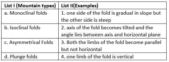
Match List I with List II

Detailed Solution for APSET Paper 2 Mock Test - 1 (Geography) - Question 16
  • Monoclinal Folds are referred to those where the compressional forces act in such a way that one limb of the fold is totally vertical.
  • Isoclinal folds, also known as Overfolds are formed when the compressional forces are so strong that both the sides of the fold are inclined in the same direction. The short and steep side also dips in the same direction as the flat or gradual sloping side but the sides of the fold are not horizontal
  • Asymmetrical folds are formed when one limb of the fold is pushed too far so that one side of the fold is long and gradual in slope while the other is short and steep. This shows a unilateral element.
  • Plunge folds are found when the axis of the fold, instead of being parallel to the horizontal plane becomes tilted and forms plunge angle, which is the angle between the axis and the horizontal plane.
APSET Paper 2 Mock Test - 1 (Geography) - Question 17

Mean, median and mode are also called

Detailed Solution for APSET Paper 2 Mock Test - 1 (Geography) - Question 17

Measures of central tendency provide us with a summary that describes some central or middle point of the data. There are five important measures of central tendency, viz., i) arithmetic mean, ii) median, iii) mode, iv) geometric mean, and v) harmonic mean. Out of these the last two measures, viz., geometric mean and harmonic mean, have very specific uses and thus less frequently used.

  • Mode: The word mode has been derived from the French word “la Mode” which signifies the most fashionable values of distribution because it is repeated the highest number of times in the series. The mode is the most frequently observed data value. It is denoted by Mo.
    • The mode is seldom used and its computation is easy, but it is highly unstable and may change with minor shifts in the frequencies from one interval to another.
    • However, there are situations in which the only mode can be used.
    • For example, if a shoe company wants to how which size of shoe it should produce more, it would use mode as a measure of central tendency. The most frequently sold size of the shoes is the mode.
  • Arithmetic mean: The arithmetic mean is the most commonly used measure of central tendency. The mean represents the central tendency. It is defined as the sum of the values of all observations divided by the number of observations and is usually denoted by X. In general, if there are N observations as X1, X2, X3, ..., XN, then the Arithmetic Mean is given by
    Mean= .
    This will be written in simpler form without the index i.
    Thus mean = N ∑ (X/N) where, ΣX = sum of all observations and N = total number of observations.
  • Median is that positional value of the variable which divides the distribution into two equal parts, one part comprises all values greater than or equal to the median value and the other comprises all values less than or equal to it. The Median is the “middle” element when the data set is arranged in order of magnitude. Since the median is determined by the position of different values, it remains unaffected if, say, the size of the largest value increases. The median can be easily computed by sorting the data from smallest to largest and finding out the middle value.
  • The geometric mean is defined as the nth root of the product of n numbers. The geometric mean of a data set {a1, a2, ....an} is given by:

  • Harmonic mean of any two numbers can be calculated by 

APSET Paper 2 Mock Test - 1 (Geography) - Question 18
Which of the following statements relating to industrial regions are correct?

(a) With shift in technology, there has been a shift in the structure of industries.

(b) The globalization has caused a new international division of labour.

(c) The high tech industrial regions have very little to no place for blue collar jobs.

(d) R&D is the most important feature of traditional large scale industrial regions.

Choose the correct option from below:

Detailed Solution for APSET Paper 2 Mock Test - 1 (Geography) - Question 18

With the shift in technology, the structure of industries has changed considerably with the manufacturing low grade industries being shifted to the southern countries like Bangladesh, India. The advanced economies have kept the high-paying research intensive jobs within the same industries. The globalization and the unrestricted flow of capital has induced a new international division of labour where specialized goods and service is produced by workers of specific economies. Blue collar workers are characteristic of traditional heavy industries and the gold collar workers engaged R&D are characteristic of the hi-tech industries.

APSET Paper 2 Mock Test - 1 (Geography) - Question 19
Which of the following is/are formed by subduction between a plate carrying continental crust and a plate carrying oceanic crust? 
Detailed Solution for APSET Paper 2 Mock Test - 1 (Geography) - Question 19

The correct answer is Ocean trench.Key Points

  • Ocean trenches are formed by subduction between a plate carrying continental crust and a plate carrying oceanic crust.
  • Ocean trenches are a feature of convergent plate boundaries, where two or more tectonic plates meet.
  • At many convergent plate boundaries, dense lithosphere melts or slides beneath less-dense lithosphere in a process called subduction, creating a trench.
  • A subduction zone is a collision between two of Earth's tectonic plates, where one plate sinks into the mantle underneath the other plate.
  • A transform fault or transform boundary, is a fault along a plate boundary where the motion is predominantly horizontal.
  • Normal faults are inclined fractures where the blocks have mostly shifted vertically.

Additional Information

  • The World's deepest oceanic trench is Mariana.
  • The Mariana Trench is located in the western Pacific Ocean about 200 kilometers east of the Mariana Islands.
    • It is the deepest oceanic trench on Earth.
    • It is 1,580 miles long and averages just 43 miles wide.
    • It is home to the Challenger Deep, which, at 10,911 meters (35,797 feet), is the deepest part of the ocean.
APSET Paper 2 Mock Test - 1 (Geography) - Question 20
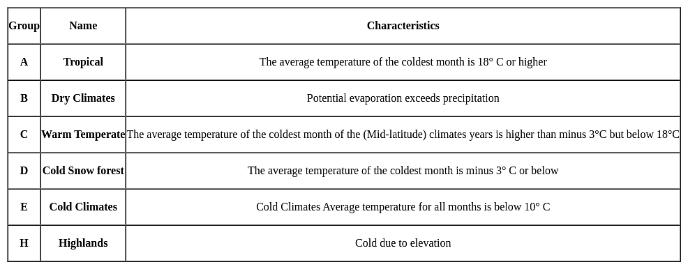
Koeppen recognised five major climatic groups, four of them are based on temperature and one on precipitation. Identify the one among the following which is based on precipitation?
Detailed Solution for APSET Paper 2 Mock Test - 1 (Geography) - Question 20

The correct answer is Dry Climates.

Key PointsKoeppen’s Classification of climate:

  • Koeppen’s Classification of climate is the most commonly used classification of climate.
  • It was developed by Wladimir Peter Koeppen in 1884.
  • If the annual precipitation is,
    • Less than 50% of the threshold, the classification is BW (arid: desert climate) and
    • If it is in the range of 50%–100% of the threshold, the classification is BS (semi-arid: steppe climate).
  • The seasons of dryness are indicated by the small letters -
    • f - no dry season
    • m - Monsoon climate
    • w - Winter dry season
    • s - Summer dry season

Additional Information

  • Koeppen’s Classification:
APSET Paper 2 Mock Test - 1 (Geography) - Question 21

Which of the following statement is not correct about andesitic or acidic lava?

Detailed Solution for APSET Paper 2 Mock Test - 1 (Geography) - Question 21

The correct answer is They are dark coloured basalt, rich in iron and magnesium but poor in silica

Important Points

  • ACIDIC: Magma is composed of molten rock and is stored in the Earth’s crust. Lava is magma that reaches the surface through a volcano vent.
    • These lavas are highly viscous with a high melting point.
    • They are light-colored, of low density, and have a high percentage of silica.
    • They flow slowly and seldom travel far before solidifying.
    • The resultant volcanic cone is therefore stratified (hence the name stratovolcano) and steep-sided.
    • Andesitic lava flow occurs mostly along the destructive boundaries (convergent boundaries).
  • BASIC: These are the hottest lavas, about 1,000 °C, and are highly fluid.
    • They are dark coloured basalt, rich in iron and magnesium but poor in silica.
    • They flow out of volcanic vent quietly and are not very explosive.
    • Due to their high fluidity, they flow readily with a speed of 10 to 30 miles per hour.
    • They affect extensive areas, spreading out as thin sheets over great distances before they solidify.
    • The resultant volcano is gently sloping with a wide diameter and forms a flattened shield or dome.
    • Shield type lava flow is common along the constructive boundaries (divergent boundary).
APSET Paper 2 Mock Test - 1 (Geography) - Question 22

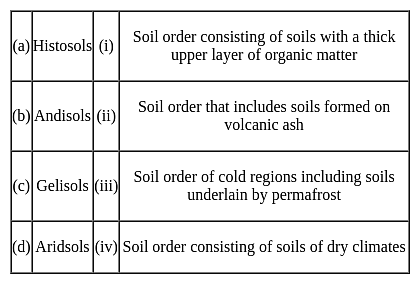
Match the following soil orders with their descriptions:
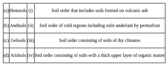

Choose the correct option from those given below:

Detailed Solution for APSET Paper 2 Mock Test - 1 (Geography) - Question 22

The recent system of Soil classification which is being used in India has been developed in U.S.A after it was passed through various stages and the last one is 7th approximation (Soil Survey Staff, 1960). Later this system of soil classification was published as USDA soil Taxonomy which has been modified a number of times and recently it has been further modified and improved in 1998(Soil Survey Staff, 1998)

1) Histosols

  • Histosols account for 10% of the land area.
  • These are soils that are mainly composed of organic materials.
  • Its key property is the presence of a large number of organic materials.
  • The organic deposit range between 147 and 180 cm and organic carbon level between 32 and 54 %.
  • The proportion of 70 % of histosols occurs in the frigid northern zone.

2) Andisols

  • Andisols are mostly formed by the weathering products of volcanic rocks, are able to store organic carbon at a considerably high proportion compared to other types of soils.
  • Andisols contribute to only 0.8% of the ice-free surface on our planet. Yet, due to their average 8-12% Organic carbon content, they are able to sequester more than 1.8% of the soil carbon stock globally. And this nature of volcanic soils is well documented and is associated with their relatively higher content of poorly crystalline mineral.

3) Gelisols:

  • Frost Churning(cryoturbation) plays a critical role in the formation of this soils it is done through ground patterning, the sequestration of organic matter below the soil surface, and alterations to the physical structure of soil materials.
  • Additionally, the Turbel suborder and Turbic subgroups of other suborders are defined by the presence of cryoturbated horizons and gelic materials, which "are manifested by involuted, irregular, or broken horizons, organic matter near or within the permafrost table, oriented rock fragments, and silt enriched layers.

4) Aridsols

  • Aridsols are the soil of the dry region.
  • These are found at much higher under humid climatic conditions than under arid climatic conditions.
  • Aridsols have a very low level of organic matter. As a result, It lacks vegetative production due to its dry nature.

Hence,

APSET Paper 2 Mock Test - 1 (Geography) - Question 23

Read the following statements for physical features of India and choose the correct options:

A. Many popular hill stations are situated in middle Himalaya.

B. Northern plains are highly populated areas because river plains have fertile land for cultivation.

C. Western ghats are rich in minerals and are highly populated.

Detailed Solution for APSET Paper 2 Mock Test - 1 (Geography) - Question 23

Let's look at the statements of physical features of India:

  • Statement A - Correct. There are several hill stations in the middle Himalayas such as Barog, Barog, Barot, Tattapani, Triund, Rohtang, Reckong Peo, Palampur, Narkanda, Mashobra, Manali, Kullu, Kufri, Khajjiar, Kasauli, Kalpa, Dharamshala, Dalhousie, Chitkul, Chamba, and Chail.
  • Statement B- Correct. The northern plains are also known as deposited plains due to the availability of Fertile soil, which is suitable for agriculture and cultivation. This prompted many people to settle along the shores of the various northern rivers.
  • Statement C- Incorrect. Western Ghats are best known for their biological diversity and endemism. Also, it one of the world's eight hottest hotspots of biodiversity.

Hence, we can say that only statements A and B are correct.

APSET Paper 2 Mock Test - 1 (Geography) - Question 24
Which one from the followings is NOT an effect of El-Nino? 
Detailed Solution for APSET Paper 2 Mock Test - 1 (Geography) - Question 24

The correct answer is It lowers down the temperature of water on the Peruvian coast.

Key Points

  • El Niño is a climate pattern that affects atmospheric circulation and temperatures in the Pacific Ocean, with wide-ranging impacts on global weather and ocean conditions. 
  • El Niño distorts equatorial atmospheric circulation. This can cause significant alterations in weather patterns around the world.
  • El Niño can cause irregularities in the evaporation of sea water. It mainly changes the pattern of rainfall across the Pacific and Indian Oceans, which could lead to changes in evaporative patterns.
  • El Niño reduces the number of fish in the sea. As it disturbs water temperature and nutrient availability, El Niño could affect food chains and cause a decline in fish populations, particularly in the Eastern Pacific.
  • But, El Niño does not lower the temperature of the water on the Peruvian coast. In fact, El Niño conditions are characterized by unusually warm ocean temperatures in the Equatorial Pacific, including along the Peruvian coast, not cooler temperatures.

Additional Information

  • The term El Niño means "The Little Boy" or "Christ Child" in Spanish.
  • It was originally used by fishermen along the coasts of Ecuador and Peru to refer to the unusually warm waters that reduced their fish catches.
  • Today, El Niño refers to the broad-scale warming of the equatorial Pacific that takes place every 2-7 years and lasts between six to 18 months.
APSET Paper 2 Mock Test - 1 (Geography) - Question 25

The term cadastral is derived from the ______ word cadestre meaning register of territorial property.

Detailed Solution for APSET Paper 2 Mock Test - 1 (Geography) - Question 25

The term cadastral is derived from the French word cadestre meaning register of territorial property.

APSET Paper 2 Mock Test - 1 (Geography) - Question 26

Considering the insolation received in 100, which of the following statements is/are correct regarding the heat budget of the Earth?

1. Around 35 units are reflected back before reaching the surface of the Earth.

2. 65 units are absorbed by the atmosphere and the Earth’s surface.

3. The earth radiates back 51 units as terrestrial radiation.

Select the correct answer from the options given below.
Detailed Solution for APSET Paper 2 Mock Test - 1 (Geography) - Question 26
  • The earth as a whole does not accumulate or lose heat. It maintains its temperature.
  • This can happen only if the amount of heat received in the form of insolation equals the amount lost by the earth through terrestrial radiation.
  • Consider that the insolation received at the top of the atmosphere is 100 percent.
  • While passing through the atmosphere some amount of energy is reflected, scattered and absorbed. Only the remaining part reaches the earth surface.
  • Roughly 35 units are reflected back to space even before reaching the earth’s surface. Of these, 27 units are reflected back from the top of the clouds and 2 units from the snow and ice-covered areas of the earth. The reflected amount of radiation is called the albedo of the earth.
  • The remaining 65 units are absorbed, 14 units within the atmosphere and 51 units by the earth’s surface.
  • The earth radiates back 51 units in the form of terrestrial radiation. Of these, 17 units are radiated to space directly and the remaining 34 units are absorbed by the atmosphere (6 units absorbed directly by the atmosphere, 9 units through convection and turbulence and 19 units through latent heat of condensation).
  • 48 units absorbed by the atmosphere (14 units from insolation +34 units from terrestrial radiation) are also radiated back into space.
  • Thus, the total radiation returning from the earth and the atmosphere respectively is 17 + 48 = 65 units which balance the total of 65 units received from the sun.
  • This is termed the heat budget or heat balance of the earth.
  • This explains why the earth neither warms up nor cools down despite the huge transfer of heat.
APSET Paper 2 Mock Test - 1 (Geography) - Question 27
According to the Central Place Theory, the Transport Principle can express as
Detailed Solution for APSET Paper 2 Mock Test - 1 (Geography) - Question 27

Walter Christaller, in his Central Place Theory gave three principles for proper arrangement and hierarchy. The Transport Principle is the scenario that denotes efficient transport network. It involves the connection of all central places in hierarchical order. The transport principle is given by k=4.

Thus, the correct answer is B.

APSET Paper 2 Mock Test - 1 (Geography) - Question 28
Ozone is composed of atoms of which element ? 
Detailed Solution for APSET Paper 2 Mock Test - 1 (Geography) - Question 28

The Correct answer is Oxygen.

  • Ozone is a molecule composed of three atoms of oxygen, also referred to as O3.
  • A layer of ozone is present in the stratosphere of Earth and prevents the UV rays from reaching the Earth's surface.
  • It is an allotrope of Oxygen.
  • Ozone, or tri-oxygen, is an inorganic molecule with the chemical formula O3.
  • It is a pale blue gas with a distinctively pungent smell.
  • Ozone is an excellent oxidizing agent as it breaks down into oxygen gas and nascent oxygen. { O3 → O2 + [O] }.
  • It is an allotrope of oxygen that is much less stable than the diatomic allotrope O2, breaking down in the lower atmosphere to O2 or di-oxygen.
APSET Paper 2 Mock Test - 1 (Geography) - Question 29
Choose the correct option:-
Detailed Solution for APSET Paper 2 Mock Test - 1 (Geography) - Question 29

The international trade is termed as the Economic barometer of a country because when one country exchanges goods with another country, it is known as foreign trade. This trade leads to economic prosperity and is important both as a source of imports and exports. The international trade is termed as an economic barometer as it shows the trend of the exports and imports and general economy.

From 2000-01, India's foreign trade grew up to a great extent, improved global growth and various policy initiatives were responsible for the improved exports. Another reason that led to this performance was that the value of exports had increased.

APSET Paper 2 Mock Test - 1 (Geography) - Question 30

Given below are two statements. One is labelled as Assertion (A) and the other is labelled as Reason (R).

Assertion (A): There is high density of population in Chotanagpur plateau.

Reason (R) : Various minerals are found in the Chotanagpur plateau.

Select the correct answer from options given below:

Detailed Solution for APSET Paper 2 Mock Test - 1 (Geography) - Question 30

 The Chotanagpur plateau of Jharkhand has abundance of minerals such as iron, coal, copper, bauxite, etc. The area thus provides employment opportunities in mining and other heavy industries. This has led to high density of population in the Chotanagpur plateau. Thus, both (A) and (R) are true and (R) is the correct explanation of (A).

View more questions
60 tests
Information about APSET Paper 2 Mock Test - 1 (Geography) Page
In this test you can find the Exam questions for APSET Paper 2 Mock Test - 1 (Geography) solved & explained in the simplest way possible. Besides giving Questions and answers for APSET Paper 2 Mock Test - 1 (Geography), EduRev gives you an ample number of Online tests for practice

Top Courses for AP TET

Download as PDF

Top Courses for AP TET