AP TET Exam  >  AP TET Tests  >  APSET Mock Test Series 2025  >  APSET Paper 2 Mock Test - 3 (Geography) - AP TET MCQ

APSET Paper 2 Mock Test - 3 (Geography) - AP TET MCQ


Test Description

30 Questions MCQ Test APSET Mock Test Series 2025 - APSET Paper 2 Mock Test - 3 (Geography)

APSET Paper 2 Mock Test - 3 (Geography) for AP TET 2024 is part of APSET Mock Test Series 2025 preparation. The APSET Paper 2 Mock Test - 3 (Geography) questions and answers have been prepared according to the AP TET exam syllabus.The APSET Paper 2 Mock Test - 3 (Geography) MCQs are made for AP TET 2024 Exam. Find important definitions, questions, notes, meanings, examples, exercises, MCQs and online tests for APSET Paper 2 Mock Test - 3 (Geography) below.
Solutions of APSET Paper 2 Mock Test - 3 (Geography) questions in English are available as part of our APSET Mock Test Series 2025 for AP TET & APSET Paper 2 Mock Test - 3 (Geography) solutions in Hindi for APSET Mock Test Series 2025 course. Download more important topics, notes, lectures and mock test series for AP TET Exam by signing up for free. Attempt APSET Paper 2 Mock Test - 3 (Geography) | 100 questions in 120 minutes | Mock test for AP TET preparation | Free important questions MCQ to study APSET Mock Test Series 2025 for AP TET Exam | Download free PDF with solutions
APSET Paper 2 Mock Test - 3 (Geography) - Question 1

Which of the following is NOT a component of Green Revolution? Choose your answer from the code given below:

a) Guaranteed employment

b) High Yielding Variety(HYI) of seeds

c) Rural electrification

d) No Poverty

e) Agricultural Universities

f) Land Reforms

Detailed Solution for APSET Paper 2 Mock Test - 3 (Geography) - Question 1

The high Yielding Variety(HYV) of seeds and agricultural universities are ways of optimizing agricultural output through advanced technology. It is a very important component of Green Revolution. Land Reforms such as abolishment of Raitwari and Zamindari system led to improvement in agricultural sector and was important for Green Revolution. The rural electrification guaranteed irrigation for agriculture and thus a part of Green Revolution. No Poverty as well as Employment guarantee, on the other hand , were not the components of Green Revolution.

Thus, the correct answer is C.

APSET Paper 2 Mock Test - 3 (Geography) - Question 2

Use the information below to answer the question that follows.

• fluctuating water table

• large herbivores, carnivores, and scavengers

• tall, coarse grass

• low-growing, drought-resistant tree species

The information presented best describes major features of which of the following grassland biomes?

Detailed Solution for APSET Paper 2 Mock Test - 3 (Geography) - Question 2

This question requires the examinee to demonstrate knowledge of the distribution and characteristics of major global and regional ecosystems. Major tropical savanna grasslands can be found in northern and eastern India, northern Australia, south central Africa, western Central America, and the Llanos region of Venezuela. Their major features include fluctuating water tables, leached soils, large herbivores, carnivores, and scavengers, tall, coarse grass, and scattered low-growing, drought-resistant trees, scrub, and thorn bushes.

1 Crore+ students have signed up on EduRev. Have you? Download the App
APSET Paper 2 Mock Test - 3 (Geography) - Question 3

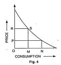
The spreading and merging of places from different cultures including food, clothing, and even languages that people love and enjoy every day is known as -
Detailed Solution for APSET Paper 2 Mock Test - 3 (Geography) - Question 3

Correct Answer: Cultural diffusion.

Key Points 

Cultural diffusion:

  • Cultural diffusion is the spreading out and merging of pieces from different cultures.
  • These different cultures all have many diverse types of food, clothing, and even languages that people love and enjoy every day. 
  • The definition of cultural diffusion is the spread of the beliefs and social activities of one culture to different ethnicities, religions, nationalities, etc.
  • An example of cultural diffusion is the tradition of the German Christmas pickle becoming popular in the United States.

Additional Information 

Convergence culture:

  • Convergence culture is a theory that recognizes changing relationships and experiences with new media. Henry Jenkins is accepted by media academics to be the father of the term with his book Convergence Culture: Where Old and new media collide.

Cultural ecology:

  • Cultural ecology is the study of the adaptation of a culture to a specific environment and how changes in that environment lead to changes in that specific culture.
  • Cultural ecology is the study of human adaptations to social and physical environments.
  • Human adaptation refers to both biological and cultural processes that enable a population to survive and reproduce within a given or changing environment.
  • This may be carried out diachronically, or synchronically.​​

Culture Hearths:

  • Culture Hearths are the centers of origin of ancient civilizations which continue to inspire and influence modern societies of the world today. ​
APSET Paper 2 Mock Test - 3 (Geography) - Question 4
The following model of industrial location was given by

Detailed Solution for APSET Paper 2 Mock Test - 3 (Geography) - Question 4

The model is representation of Profit Maximization Theory given by August Losch. The primary objective of this theory was to decide the best possible location for industries. Losch rejected Weber’s model completely. He was of the opinion that industries would be located at a place where they would get maximum profit rather than the place with least cost.

Thus, the correct answer is A.

APSET Paper 2 Mock Test - 3 (Geography) - Question 5

Consider the following statements about Equator and choose the correct option:

(A) The equator is a real line running on the globe, which divides it into two equal parts.

(B) The equator is the longest latitude.

(C) The equator represents the 180° latitude.

Detailed Solution for APSET Paper 2 Mock Test - 3 (Geography) - Question 5

The correct option is: Only (B)are true.
Important Points

(A)The equator is a real line running on the globe, which divides it into two equal parts.

  • The statement is incorrect.
  • The equator is an imaginary line running horizontally around the Earth, dividing it into the Northern Hemisphere and the Southern Hemisphere.
  • It is not a real physical line on the Earth's surface.

(B) The equator is the longest latitude.

  • The statement is true.
  • The equator is the longest latitude line. It is the largest circle of latitude, measuring approximately 40,075 kilometers or 24,901 miles in length.

(C) The equator represents the 180° latitude.

  • The statement is incorrect.
  • The Equator represents 0° latitude.
  • It is the imaginary line that equally divides the Northern and Southern Hemispheres.
  • Latitude lines are measured from the Equator, with values increasing up to 90° north at the North Pole and 90° south at the South Pole.
  • The 180° line you may be thinking of is the 180° longitude line, which is part of the system used to divide the Eastern and Western Hemispheres.
APSET Paper 2 Mock Test - 3 (Geography) - Question 6
Evaporation losses depend upon
Detailed Solution for APSET Paper 2 Mock Test - 3 (Geography) - Question 6

The correct answer is All of the options.Key Points

The rate of evaporation depends on temperature, the presence of wind, the humidity of the surrounding, and the surface area and mass of the liquid exposed to the atmosphere.

  • The higher the precipitation, the lesser would be the rate of evaporation. Hence, option 1 is true.
  • The larger the water surface and depth of the water, the more would be the rate of evaporation. Hence, option 3 is true.
  • The higher the humidity, the slower would be the rate of evaporation.
  • The higher the presence of wind, the faster would be the rate of evaporation. Hence, option 4 is true.
  • The higher the temperature, the faster would be the rate of evaporation.
APSET Paper 2 Mock Test - 3 (Geography) - Question 7

For whom it has been rightly remarked that he followed the precedent of Humboldt, attempted to revive the close connection of geography to natural sciences, and at the same time restored the Ritterian tradition and sought to fulfil the methodology of Peschel.

Detailed Solution for APSET Paper 2 Mock Test - 3 (Geography) - Question 7

Answer: Option 3) Richthofen.

Key Points

  • Richthofen was the first German scholar, who had differentiated between 'general' and 'regional' geography.
  • He stressed that regional geography should be descriptive to highlight the key features of an area.
  • General geography, according to him, is related to the spatial distribution of personal events in the world. 
  • For systematic regional studies, he emphasized the need for regional work.
  • For regional studies, he used the term 'chorology' and differentiated it from “chorography” (non explanatory description providing information for systematic geography).

Additional Information

  •  Vidal de la Blache:

Paul Vidal de la Blache (1845-1918) was a French geographer who had a profound influence on the development of modern geography. He produced a large number of publications, including books, articles, and reports. Vidal de la Blache followed the precedent of Alexander von Humboldt, attempted to revive the close connection of geography to natural sciences, restored the Ritterian tradition, and sought to fulfill the methodology of Oscar Peschel.

  • Darwin:

Charles Darwin (1809-1882) was an English naturalist, geologist, and biologist, best known for his theory of evolution. His work had a profound influence on the development of many scientific fields, including geography. Vidal de la Blache was an admirer of Darwin's work, and he incorporated Darwinian ideas into his own geographical theories.

  • Reclus:

Élisée Reclus (1830-1905) was a French geographer and anarchist. He was a prolific writer and produced a number of influential works on geography. Vidal de la Blache and Reclus were contemporaries, and they shared many of the same ideas about geography.

APSET Paper 2 Mock Test - 3 (Geography) - Question 8

What did Ratzel compare a state to in his work "Political Geography"

Detailed Solution for APSET Paper 2 Mock Test - 3 (Geography) - Question 8

Answer: 4) A living Organism.

Key Points

  • Fredrich Ratzel is the founder of modern human geography.
  • He has extended significant contribution in the development of human geography.
  • Ratzel wrote an epic named “Anthropogeography”.
  • In his work "Political Geography", Ratzel compared a state to a living organism. He believed that states, like living organisms, are born, grow, and eventually die.
  • He also believed that states, like living organisms, need to adapt to their environment in order to survive.
  • Ratzel's analogy between states and living organisms was controversial at the time, but it has since become a widely accepted concept in political geography. Today, it is common to refer to states as "political organisms" or "geopolitical entities".

Therefore, the correct answer is option 4) A living organism. Ratzel compared a state to a living organism in his work "Political Geography".

APSET Paper 2 Mock Test - 3 (Geography) - Question 9

Consider the following -

1. Methane

2. Nitrous Oxide

3. Halons

Which of the above is/are responsible for depletion of stratospheric ozone?

Detailed Solution for APSET Paper 2 Mock Test - 3 (Geography) - Question 9

The correct answer is 1, 2 and 3.

Key Points

  • Ozone layer depletion the reduction of the amount of ozone in the stratosphere.
    • It occurs when chlorine and bromine atoms come into contact with ozone in the stratosphere, they destroy ozone molecules.
    • Ozone-depleting substances (ODS), which include chlorofluorocarbons (CFCs) and hydrofluorocarbons (HCFCs), were once used widely in refrigerants, insulating foams, solvents, and other applications.
    • Other chemicals that damage the ozone layer include methyl bromide (used as a pesticide), halons (used in fire extinguishers), and methyl chloroform (used as a solvent in industrial processes). 
  • Methane can react with other gases to form water vapor, which then breaks down into other chemicals that destroy ozone.
  •  Nitrous Oxide affect Ozone depletion.
    • The compound reacts with high-energy oxygen atoms to produce a deadlier compound, nitric oxide (NO). This then goes on to destroy ozone, a molecule made up of three oxygen atoms.
  • Halons are ozone depleting substances whose production and consumption is controlled under the Montreal Protocol.
    • All halons contain bromine which is 40-100 times more effective at destroying ozone than chlorine.

Additional Information

  • Stratosphere
    •  It is the second layer of the atmosphere found above the troposphere.
    • It extends up to 50 km of height.
    • This layer provides some advantages for flight because it is above stormy weather and has steady, strong, horizontal winds.
    • The ozone layer is found in this layer. The ozone layer absorbs UV rays and safeguards the Earth from harmful radiation.
    • Stratopause separates stratosphere and mesosphere.​ 
APSET Paper 2 Mock Test - 3 (Geography) - Question 10
The spread of cultural traits from one region to other is called:
Detailed Solution for APSET Paper 2 Mock Test - 3 (Geography) - Question 10

The correct answer is Diffusion.

Key Points

  • The spread of cultural traits from one region to another is called cultural diffusion.
  • Cultural diffusion often occurs when people move from one place to another.
  • It is the geographical and social spread of the different aspects of one more culture to different ethnicities, religions, nationalities, regions, etc.

Additional Information

APSET Paper 2 Mock Test - 3 (Geography) - Question 11
Given below are two statements. One is labelled as Assertion (A) and the other is labelled as Reason (R).

Assertion(A)- According to Anthony Giddens human agency and social structure are not two separate concepts.

Reason(R)- Structure is a continuous process which is carried out in a flow.

Select the correct answer from options given below:

Detailed Solution for APSET Paper 2 Mock Test - 3 (Geography) - Question 11

Structuration theory was majorly propounded by Giddens and Bourdieu. According to Giddens human agency and social structure are not two separate concepts or constructs, but these are together produced by social action and interaction. He states it as an outcome of a continuous process or flow of process.

Thus, the Correct answer is A.

APSET Paper 2 Mock Test - 3 (Geography) - Question 12
The spreading and merging of places from different cultures including food, clothing, and even languages that people love and enjoy every day is known as -
Detailed Solution for APSET Paper 2 Mock Test - 3 (Geography) - Question 12

Correct Answer: Cultural diffusion.

Key Points 

Cultural diffusion:

  • Cultural diffusion is the spreading out and merging of pieces from different cultures.
  • These different cultures all have many diverse types of food, clothing, and even languages that people love and enjoy every day. 
  • The definition of cultural diffusion is the spread of the beliefs and social activities of one culture to different ethnicities, religions, nationalities, etc.
  • An example of cultural diffusion is the tradition of the German Christmas pickle becoming popular in the United States.

Additional Information 

Convergence culture:

  • Convergence culture is a theory that recognizes changing relationships and experiences with new media. Henry Jenkins is accepted by media academics to be the father of the term with his book Convergence Culture: Where Old and new media collide.

Cultural ecology:

  • Cultural ecology is the study of the adaptation of a culture to a specific environment and how changes in that environment lead to changes in that specific culture.
  • Cultural ecology is the study of human adaptations to social and physical environments.
  • Human adaptation refers to both biological and cultural processes that enable a population to survive and reproduce within a given or changing environment.
  • This may be carried out diachronically, or synchronically.​​

Culture Hearths:

  • Culture Hearths are the centers of origin of ancient civilizations which continue to inspire and influence modern societies of the world today. ​
APSET Paper 2 Mock Test - 3 (Geography) - Question 13
Which among the following is a true statement?
Detailed Solution for APSET Paper 2 Mock Test - 3 (Geography) - Question 13

The true statement among the given options is: Inner planets are made up of rocks. Important PointsInner planets, also known as terrestrial planets, are composed mainly of rocks and metals.

  • These planets are located closer to the Sun compared to the outer planets.
  • The inner planets in our solar system are Mercury, Venus, Earth, and Mars. They have solid surfaces and are primarily composed of materials such as silicates, iron, and other rocky substances.

On the other hand, the outer planets, also known as gas giants or giant planets, are primarily composed of gases like hydrogen and helium.

  • They are much larger in size compared to the inner planets. The outer planets in our solar system are Jupiter, Saturn, Uranus, and Neptune.

Therefore, the statement "Inner planets are made up of rocks" is true.

APSET Paper 2 Mock Test - 3 (Geography) - Question 14
Which one of the following is the correct sequence of cultural change as given by Lewis Mumford?
Detailed Solution for APSET Paper 2 Mock Test - 3 (Geography) - Question 14

Lewis Mumford gave 6 stage of cultural change of town in his theory of origin of towns. These were Eoplis is a rising village. Polis is a small market town. Metropolis has specialized activities and a sphere of influence. Megalopolis is wealth-dominant city. Tyrannopolis has wealth but also abundance of crimes. Necropolis is the city of dead, with environmental problems.

Thus, the correct answer is A.

APSET Paper 2 Mock Test - 3 (Geography) - Question 15

Which of the following agricultural system regions for the world are given by Whittlesey?

(a) Viticulture

(b) Rudimentary sedentary Tillage

(c) Specialized horticulture

(d) Commercial dairy farming

Choose the correct option from below:

Detailed Solution for APSET Paper 2 Mock Test - 3 (Geography) - Question 15

D Whittlesey in 1936 gave a 13 regions classification for the agricultural system regions of the world. Rudimentary sedentary Tillage constituted the few pockets in and around regions of shifting cultivation, which relatively more settled agriculturists lived than the former. E.g. S.E. Asia, Central and South America. Commercial dairy farming is practiced in the most developed parts of the world like Northern and western Europe, Australia. Specialized horticulture is practiced in the densely populated industrial districts of Denmark, Britain, France, Germany etc.

APSET Paper 2 Mock Test - 3 (Geography) - Question 16

Which state is the largest producer of tea in India ?

Detailed Solution for APSET Paper 2 Mock Test - 3 (Geography) - Question 16

Assam is the largest producer of tea in India. India is one of the largest producers of tea in the world, second only to China.

APSET Paper 2 Mock Test - 3 (Geography) - Question 17

Which among the following state of India is best known for Saffron Cultivation?

Detailed Solution for APSET Paper 2 Mock Test - 3 (Geography) - Question 17

Kashmir saffron is a high value, low volume crop and the quality of saffron is among the best in the world particularly because of its rich color and flavour. A small area in the valley, Pampore has the virtual monopoly of saffron cultivation in the country.

Thus, the correct answer is A.

APSET Paper 2 Mock Test - 3 (Geography) - Question 18

Which among the following factors influence the salinity of ocean water?

1. Precipitation

2. Evaporation

3. Ocean Currents

4. Temperature

Select the correct code from the options given below:
Detailed Solution for APSET Paper 2 Mock Test - 3 (Geography) - Question 18

The correct answer is 1, 2, 3 and 4.

Key Points

Salinity:

  • All waters in nature, whether rainwater or ocean water, contain dissolved mineral salts.
  • Salinity is the term used to define the total content of dissolved salts in seawater.
  • It is calculated as the amount of salt (in gm) dissolved in 1,000 gm (1 kg) of seawater.
  • It is usually expressed as parts per thousand (‰) or ppt.
  • Salinity is an important property of seawater.
  • The main source of Salinity is the dissolution of the rocks of oceanic crust which contains salts
  • The salinity of 24.7ppt (parts per thousand) has been considered as the upper limit to demarcate ‘brackish water'.

Factors affecting ocean salinity:

  • The salinity of water in the surface layer of oceans depends mainly on evaporation and precipitation.
  • Surface salinity is greatly influenced in coastal regions by the freshwater flow from rivers, and in polar regions by the processes of freezing and thawing of ice.
  • Wind also influences the salinity of an area by transferring water to other areas.
  • The ocean currents contribute to the salinity variations.
  • Salinity, temperature and density of water are interrelated.
  • Hence, any change in the temperature or density influences the salinity of water in an area.

Evaporation:

  • It is higher at places with high rates of evaporation.

Temperature:

  • Regions with high temperatures have waters with high salinity.
  • Variations in the density or temperature affect the salinity of water in that area.

Precipitation:

  • It shares an inverse relationship with salinity.
  • Regions with higher levels of precipitation have lower levels of salinity.

Ocean Currents:

  • It affects the spatial distribution of salts in the ocean by mixing sea waters.
  • Variations in the salinity of the ocean water also contribute to the formation of ocean currents.

The Influx of Fresh Water:

  • There is a negative relationship.
  • The salinity of oceans decreases with more influx of fresh water from rivers to oceans.
  • In the Polar region, the surface salinity is influenced by the processes of freezing & melting of ice.


Thus, Precipitation, Evaporation, Ocean Currents and Temperature all influence the salinity of ocean water.

Additional Information

APSET Paper 2 Mock Test - 3 (Geography) - Question 19
The East-West Corridor connects which of the following cities?
Detailed Solution for APSET Paper 2 Mock Test - 3 (Geography) - Question 19

The East-West corridor has been built to connect the cities of Silcher in Assam and Porbandar in Gujrat. The length of roads in the corridor is 3300 km. The corridor is a part of North-South-East-West Corridor, the largest ongoing highway project in the country.

Thus, the correct answer is D.

APSET Paper 2 Mock Test - 3 (Geography) - Question 20
Which of the following is NOT a force that influences ocean currents?
Detailed Solution for APSET Paper 2 Mock Test - 3 (Geography) - Question 20
  • Magnetic fields of the earth deflect most of the solar wind and have no effect on ocean currents.
  • Ocean currents have influences of Coriolis force, frictional force, and heating effect of the sun.
  • The sun heats water at the surface of the ocean which will evaporate and increase the concentration of salt and water will become dense and settle down hence whose place is taken by less dense water which leads to Ocean currents
  • Wind forces also play a major role to influence ocean currents.
APSET Paper 2 Mock Test - 3 (Geography) - Question 21
According to Malthus theory - 
Detailed Solution for APSET Paper 2 Mock Test - 3 (Geography) - Question 21

Concept:

Malthus Theory:

  • The theory of exponential population and arithmetic food supply growth is the Malthusian theory of population.
  • Thomas Robert Malthus proposed this theory.
  • It was believed by him that preventive and positive checks are the two factors that can establish a balance between population growth and food supply.

Major elements of Malthus' theory:

  • Checks on Population
    • When the increasing population rate is greater than the food supply, there exists a condition of disequilibrium.
    • The result of this is that people will not get enough food even for survival.
    • People will die due to a lack of food supply.
    • Adversities such as epidemics, wars, starvation, famines, and other natural calamities are named positive checks by Malthus.
    • Then there are man-made checks which are named preventive checks by Malthus.

Explanation:

Key points of Malthus' theory:

  • Thomas Malthus warned that without any checks, the population would theoretically grow at an exponential rate, rapidly exceeding its ability to produce resources to support itself.
  • Malthus argued that an exponentially growing population will self-correct through war, famine, and disease.
  • Malthus stated that to avoid a catastrophe such as famine and war, people should opt an intentional population control, such as birth control and celibacy.
  • Malthusian catastrophes refer to naturally occurring checks on population growth such as famine, disease, or war.
  • These Malthusian catastrophes have not taken place on a global scale due to progress in agricultural technology.
  • However, many argue that future pressures on food production, combined with threats such as global warming, make overpopulation a still more serious threat in the future.

Key terms:

  • Carrying capacity: The number of individuals of a particular species that an environment can support.
  • Exponential growth: The growth in the value of a quantity, in which the rate of growth is proportional to the instantaneous value of the quantity.
  • Malthusian catastrophes: Naturally occurring checks on population growth such as famine, disease, or war are termed Malthusian catastrophes.

Thus, according to Malthus's theory population grows geometrically whereas resources grow arithmetically.

APSET Paper 2 Mock Test - 3 (Geography) - Question 22
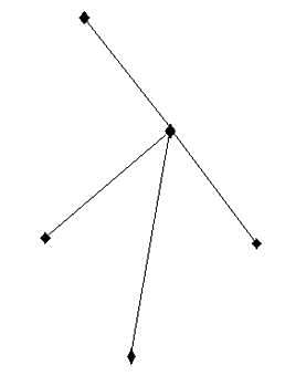
Given below are two statements. One is labelled as Assertion (A) and the other is labelled as Reason (R).

Assertion (A): Traditional Industrial regions are also called regions of smokestack industries.

Reason (R): These industries rely upon obsolete technologies causing huge pollution to air and water.

Select the correct answer from options given below:
Detailed Solution for APSET Paper 2 Mock Test - 3 (Geography) - Question 22

Traditional industrial regions has industries involving heavy manufacturing with stages like blast furnaces, smelting which causes a lot of smoke. The pollution is also, in part the result of obsolete unclean technologies. Hence, they are called regions of smokestack industries.

APSET Paper 2 Mock Test - 3 (Geography) - Question 23
The lowest known point on earth is called ________, which is present in the Pacific Ocean.
Detailed Solution for APSET Paper 2 Mock Test - 3 (Geography) - Question 23

The correct answer is Challenger Deep.

Key Points

  •  The lowest point of the Pacific Ocean is Challenger Deep in the Mariana Trench.
  • The Mariana Trench is part of a global network of deep troughs that cut across the ocean floor.
  • They form when two tectonic plates collide.
  • At the collision point, one of the plates dives beneath the other into the Earth’s mantle, creating an ocean trench.
  • Located in the western Pacific east of the Philippines and an average of approximately 124 miles (200 kilometers) east of the Mariana Islands.
  • The Mariana Trench is a crescent-shaped scar in the Earth’s crust that measures more than 1,500 miles (2,550 kilometers) long and 43 miles (69 kilometers) wide on average.
  • The distance between the surface of the ocean and the trench’s deepest point the Challenger Deep, which lies about 200 miles (322 kilometers) southwest of the U.S. territory of Guam is nearly 7 miles (11 kilometers).
  • If Mount Everest were dropped into the Mariana Trench, its peak would still be more than a mile (1.6 kilometers) underwater.
  • The majority of the Mariana Trench is now a U.S. protected zone as part of the Marianas Trench Marine National Monument, established by President George W. Bush in 2009.

Additional Information

  • Java Trench, also called Sunda Double Trench, deep submarine depression in the eastern Indian Ocean that extends some 2,000 miles (3,200 km) in a northwest-southeast arc along the southwestern and southern Indonesian archipelago.
  • The deepest part of the Atlantic Ocean is situated in the Milwaukee Deep within the east-west oriented Puerto Rico Trench.
    • Which is located around 120 km north of the island of Puerto Rico
APSET Paper 2 Mock Test - 3 (Geography) - Question 24
Calculate the Beta index of the following figure

Detailed Solution for APSET Paper 2 Mock Test - 3 (Geography) - Question 24

The beta index is the level of connectivity in a given network. The beta index is calculated with the formula,

β=e/v

where ‘e’ is no. of edges or links and ‘v’ is the no of nodes. In the given figure, edges are 4 and nodes are 5. Thus, the beta index is

4/5=0.8

Thus, the correct answer is A.

APSET Paper 2 Mock Test - 3 (Geography) - Question 25
The task of unit planning begins with the formation of appropriate units out of the prescribed course material. Which of the following subjects cannot be combined into a single unit called "Natural Resources of India"?
Detailed Solution for APSET Paper 2 Mock Test - 3 (Geography) - Question 25

Resources that are drawn from Nature and used without much modification are called natural resources. The air we breathe, the water in our rivers and lakes, the soils, minerals are all natural resources.Key PointsWater Resources, Land resources, mineral Resources, and India's Forest Resources can be combined into a single unit called "Natural Resources of India" because all these are resources that get directly from nature. Many of the resources are free gifts of nature and can be used directly, Such as-

  • Land resources: India covers an area of 32,87,263 sq km. According to area size, it is the seventh-largest country in the world after Russia, Canada, China, the U.S.A., Brazil, and Egypt. This vast size itself is the most important resource. About 30 percent of the area is covered by the mountains which are a source of scenic beauty, perennial rivers, home of forests and wildlife
  • Forest resources: Forests are our treasures which provide us a wide variety of commodities such as timber, fuel wood, fodder, fiber, fruits, herbal drugs, cosmetics, and many types of raw materials used by the industries. A great variety of mammals and birds which live in the forests, serve as useful living resources. Forests play a great role in soil formation, water conservation, and regeneration of oxygen.
  • Water resources: India is fortunate to have large water resources. Diversity in resources is the result of diversity in landforms in the form of glaciers, surface rivers, underground water, rains, and oceans.
  • Mineral resources: India is very rich in mineral resources and has the potential to become an industrial power. It possesses large reserves of iron ore, extensive deposits of coal, and mineral oil, and rich deposits of bauxite and mica.

Hence modern resources of communication cannot be combined into a single unit called "Natural Resources of India.

Hint

  • Modern Resources of communication can't be included in the unit of natural resources because modern resources of communication are mostly manmade and are not obtained from nature freely.
APSET Paper 2 Mock Test - 3 (Geography) - Question 26

Consider the following statements:

1. Seamounts are isolated steep submarine hills

2. The Andaman and Nicobar Islands are parts of seamounts projecting above the sea level.

3. The Peru Trench has been formed by subduction of the Nazca Plate below the South American plate.

4. Romanche Gap divides the Mid Pacific Ridge into two parts.

Which of the above statements is/are true?

Detailed Solution for APSET Paper 2 Mock Test - 3 (Geography) - Question 26

Seamount:

  • It is a mountain with pointed summits, rising from the seafloor that does not reach the surface of the ocean.
  • Seamounts are volcanic in origin. These can be 3,000-4,500 m tall.
  • The Emperor seamount, an extension of the Hawaiian Islands in the Pacific Ocean, is a good example.

Andaman and Nicobar Islands are the southern extension of the Himalayan ranges which have come into being due to the submerging of the intervening lowlands. They owe their origin partly to the volcanic eruptions.

The Peru–Chile Trench, also known as the Atacama Trench, is an oceanic trench in the eastern Pacific Ocean delineating the boundary between the subducting Nazca Plate and the overriding South American Plate.

Romanche Gap, also called Romanche Deep, or Romanche Trench is a narrow submarine depression lying near the Equator in the mid-Atlantic Ocean and trending east-west between the shoulders of South America and Africa.

APSET Paper 2 Mock Test - 3 (Geography) - Question 27
Match List-I with List-II:

Choose the correct option from the code given below:

Detailed Solution for APSET Paper 2 Mock Test - 3 (Geography) - Question 27

C.G. Bates in 1935 proposed that drought happens when the annual precipitation is 75% or less than normal precipitation and monthly precipitation is 60% or less than of normal monthly precipitation.

J.C. Hoyt in 1936 explained that drought occurs when annual and monthly rainfall is less than 85% of normal rainfall.

According to V.A. Conard in 1944, period of 20 or more consecutive days without 0.25 inch precipitation in 24 hours during the months of march -September.

D.A. Ramdas in 1950 claimed that drought occurs when the rainfall for a week is half normal or less.

APSET Paper 2 Mock Test - 3 (Geography) - Question 28

Directions: The question consists of two statements, an assertion and a reason. The student must first determine whether each statement is true. Each question below consists of an assertion and a reason.

Assertion (A): Tigers are an endangered species.

Reason(R): Tigers are being poached by humans.

Detailed Solution for APSET Paper 2 Mock Test - 3 (Geography) - Question 28

Assertion and reasoning type questions have one assertion (A) and one reason (R). We must first determine whether the statement is true. If the statement is true, we must next determine whether the reason correctly explains the assertion.

First, we will consider the statement of Assertion.

Tigers are globally listed as an endangered species as per the government of India and various international organizations such as the IUCN Red List of threatened species.  

Hence, the statement provided in the assertion is true.

Now we will consider the statement of Reason.

The main threat these big cats are facing is from humans only. Wild tigers are hunted to meet the demands of the $20 billion a year illegal wildlife market.

Hence, the statement provided in the reason is correct.

Conclusion- We can say the statement of Assertion and Reason are true and (R) is the correct explanation of (A)

APSET Paper 2 Mock Test - 3 (Geography) - Question 29
The Concentric circle theory of city morphology was developed by:
Detailed Solution for APSET Paper 2 Mock Test - 3 (Geography) - Question 29

The correct answer is E. Burgess.
Important Points
Concentric circle theory

  • The Concentric Circle Theory of city morphology was developed by sociologist E. Burgess in 1925.
  • Burgess was interested in studying the social organization of cities, particularly the ways in which different social groups interacted with each other in urban areas.

According to Burgess, cities grow in a series of concentric circles, with each circle representing a different type of land use and social group.

  • The innermost circle is the central business district (CBD), which is the economic and commercial hub of the city. Surrounding the CBD is the zone of transition, which is a mixed-use area characterized by industrial and residential land uses.
  • Burgess argued that this area was often home to marginalized and transient populations, including recent immigrants, the working poor, and the homeless.

The next concentric circle is the zone of working-class homes,

  • which is a predominantly residential area characterized by low-income housing and blue-collar workers. Beyond this is the zone of better residences, which is a middle-class residential area characterized by single-family homes and a higher standard of living.

Finally, the outermost concentric circle is the commuter zone, which is a suburban area where people live who commute to the central city for work.

Burgess believed that this pattern of concentric circles was universal and could be observed in cities around the world. He argued that the concentric circle model reflected the natural tendency of social groups to sort themselves based on their socio-economic status and land use needs.

In conclusion, the Concentric Circle Theory of city morphology was developed by E. Burgess and proposes that cities grow in a series of concentric circles, each with a different type of land use and social group. The innermost circle is the CBD, followed by the zone of transition, zone of working-class homes, zone of better residences, and finally the commuter zone.

APSET Paper 2 Mock Test - 3 (Geography) - Question 30

Heritage power project Sonapani mini-hydel power project is located in which state?

Detailed Solution for APSET Paper 2 Mock Test - 3 (Geography) - Question 30

Sonapani Power Project is the name of a British Era heritage mini-hydel project located at Lum Kshaid in Meghalaya. It was set up in 1925, abandoned in 1982, and again construction started in 2001. The heritage project of 1.5 MW capacity was recommissioned in December 2011.

View more questions
60 tests
Information about APSET Paper 2 Mock Test - 3 (Geography) Page
In this test you can find the Exam questions for APSET Paper 2 Mock Test - 3 (Geography) solved & explained in the simplest way possible. Besides giving Questions and answers for APSET Paper 2 Mock Test - 3 (Geography), EduRev gives you an ample number of Online tests for practice

Top Courses for AP TET

Download as PDF

Top Courses for AP TET