AP TET Exam  >  AP TET Tests  >  APSET Mock Test Series 2025  >  APSET Paper 2 Mock Test - 2 (Geography) - AP TET MCQ

APSET Paper 2 Mock Test - 2 (Geography) - AP TET MCQ


Test Description

30 Questions MCQ Test APSET Mock Test Series 2025 - APSET Paper 2 Mock Test - 2 (Geography)

APSET Paper 2 Mock Test - 2 (Geography) for AP TET 2024 is part of APSET Mock Test Series 2025 preparation. The APSET Paper 2 Mock Test - 2 (Geography) questions and answers have been prepared according to the AP TET exam syllabus.The APSET Paper 2 Mock Test - 2 (Geography) MCQs are made for AP TET 2024 Exam. Find important definitions, questions, notes, meanings, examples, exercises, MCQs and online tests for APSET Paper 2 Mock Test - 2 (Geography) below.
Solutions of APSET Paper 2 Mock Test - 2 (Geography) questions in English are available as part of our APSET Mock Test Series 2025 for AP TET & APSET Paper 2 Mock Test - 2 (Geography) solutions in Hindi for APSET Mock Test Series 2025 course. Download more important topics, notes, lectures and mock test series for AP TET Exam by signing up for free. Attempt APSET Paper 2 Mock Test - 2 (Geography) | 100 questions in 120 minutes | Mock test for AP TET preparation | Free important questions MCQ to study APSET Mock Test Series 2025 for AP TET Exam | Download free PDF with solutions
APSET Paper 2 Mock Test - 2 (Geography) - Question 1

Which of the following is a minor plate of the lithosphere?

Detailed Solution for APSET Paper 2 Mock Test - 2 (Geography) - Question 1

The correct answer is Caribbean Plate.Key Points

  • The lithosphere is divided into tectonic plates including the North American, Caribbean, South American, Scotia, Antarctic, Eurasian, Arabian, African, Indian, Philippine, Australian, Pacific, Juan de Fuca, Cocos, and Nazca
  • The Caribbean Plate is a mostly oceanic tectonic plate underlying Central America and the Caribbean Sea off the north coast of South America. It is a minor plate.

Additional Information

  • The names of the minor plates are the Scotia plate, the Nazca plate, the Cocos plate, the Caribbean plate, the Juan de Fuca, the Arabian plate, and lastly the Philippine plate.
  • The Eurasian Plate is a tectonic plate that includes most of the continent of Eurasia, with the notable exceptions of the Indian subcontinent, the Arabian subcontinent, and the area east of the Chersky Range in eastern Siberia.
  • The Antarctic Plate is a tectonic plate containing the continent of Antarctica, the Kerguelen Plateau, and some remote islands in the Southern Ocean and other surrounding oceans.
  • The Indo-Australian Plate is a major tectonic plate that includes the continent of Australia and the surrounding ocean and extends northwest to include the Indian subcontinent and the adjacent waters. It was formed by the fusion of the Indian and the Australian Plates approximately 43 million years ago.

Thus, Caribbean Plate is a minor plate of the lithosphere.

APSET Paper 2 Mock Test - 2 (Geography) - Question 2

Consider the following statements regarding the distribution of pressure belts in the globe:

1. The sub-polar low belts are thermally induced and the temperature contrast between the subtropical and the polar regions gives rise to cyclonic storms here.

2. Only vertical currents are experienced in the equatorial low belt.

3. Calm conditions with feeble and variable winds are found in the subtropical high belt.

Which of the above statements is/are correct?

Detailed Solution for APSET Paper 2 Mock Test - 2 (Geography) - Question 2

Equatorial low pressure belt:

  • Near the equator the sea level pressure is low and the area is known as equatorial low.
  • This belt is thermally produced due to heating by the sun. Due to excessive heating horizontal movement of air is absent here and only vertical currents are experienced in this belt.
  • Therefore, this belt is called doldrums (the zone of calm).
  • This belt is also known as Inter Tropical Convergence Zone (ITCZ) because the trade winds flowing from the subtropical high pressure belts converge here.


Subtropical high pressure belt:

  • Along 30° N and 30°S are found the high-pressure areas known as the subtropical highs.
  • The existence of these pressure belts is due to the fact that the rising air of the equatorial region is deflected towards poles due to the earth’s rotation.
  • After becoming cold and heavy, it descends in these regions and results in high pressure.
  • Calm conditions with feeble and variable winds are found here.
  • In the southern hemisphere, this belt is broken by small low-pressure areas in summer over Australia and South Africa.
  • In the northern hemisphere, the belt is more discontinuous by the presence of land masses, and high pressure occurs only over the ocean areas as discrete cells; these are termed the Azores and Hawaiian cells in the Atlantic and Pacific areas respectively.
  • These belts are also called Horse latitudes. In older days, vessels with cargo of horses passing through these belts found difficulty in sailing under these calm conditions. They used to throw the horses in the sea in order to make the vessels lighter.
  • In the upper atmosphere over this belt the upper level westerlies and anti-trade winds converge and set up descending currents in the atmosphere.


Sub-polar low pressure belt:

  • Further polewards along 60°N and 60°S, the low-pressure belts are termed as the subpolar lows.
  • These belts are not thermally induced; instead the winds coming from the subtropics and the polar regions converge in this belt and rise upward.
  • The great temperature contrast between the subtropical and the polar regions, gives rise to cyclonic storms in this belt.
  • In the southern hemisphere, this low pressure belt is more pronounced due to the vast presence of ocean and is referred to as the sub-antarctic low.
  • But in the northern hemisphere, there are large land masses which are very cold. Therefore, the pressure over these landmasses are increased and the continuity of the belt is broken.
1 Crore+ students have signed up on EduRev. Have you? Download the App
APSET Paper 2 Mock Test - 2 (Geography) - Question 3

Which of the following statement is correct about Fusion in remote sensing image interpretation?

Detailed Solution for APSET Paper 2 Mock Test - 2 (Geography) - Question 3

Answer: 2) The process of combining data from multiple sources or sensors to create a single, more informative image.

Key Points

  • Image fusion refers to the process of combining two or more images into one composite image, which integrates the information contained within the individual images. The result is an image that has a higher information content compared to any of the input images.
  • Remote sensing image fusion is an effective way to use the large volume of data from multisource images.
  • it can combine multi-sensor, multi- temporal, multispectral and multiresolution images for analyzing.
  • Data fusion has been used in a wide variety of applications, including remote sensing, medical imaging, and robotics.

  • Fusion in remote sensing image interpretation refers to the process of combining data from multiple sources or sensors to create a single, more informative image.

  • This can be done to improve the spatial, spectral, or temporal resolution of the data, or to extract new information that is not available from any single source.

Hence, Statement 2 "The process of combining data from multiple sources or sensors to create a single, more informative image" is correct.

APSET Paper 2 Mock Test - 2 (Geography) - Question 4

What is remote sensing image interpretation? Choose the correct option.

Detailed Solution for APSET Paper 2 Mock Test - 2 (Geography) - Question 4

Key Points

Remote sensing image interpretation

  • ​Remote sensing image interpretation is a valuable tool for a variety of applications.
  • It can be used to monitor changes in the environment, identify areas of environmental concern, and plan for future development. 
  •  The process of analyzing satellite images to identify patterns and features on the Earth's surface. This information can be used for a variety of purposes, including land use planning, environmental monitoring, and natural resource management.
  • Remote sensing images are collected by satellites that orbit the Earth. These satellites are equipped with sensors that can detect different types of electromagnetic radiation, including visible light, infrared radiation, and microwave radiation.
  • The data collected by these sensors is then processed and converted into images that can be interpreted by humans.
  • Image interpretation is a complex process that requires specialized training and knowledge. Interpreters must be able to identify the different features in an image and understand how they relate to the real world. They must also be able to use this information to draw conclusions about the landscape.

Additional Information

The process of analyzing soil samples to determine their composition: 

  • Soil sampling and analysis is a common method for assessing soil quality and fertility.
  • Soil samples are collected from different depths and locations in a field or other area of interest. The samples are then analyzed in a laboratory to determine their chemical and physical properties, such as pH, nutrient content, and texture.
  • This information can be used to make recommendations for fertilizer application, irrigation, and other management practices.

The process of analyzing water samples to determine their purity: 

  • Water quality testing is the analysis of physical, chemical, and biological characteristics of water.
  • Water samples are collected from various sources, such as rivers, lakes, streams, and groundwater wells. The samples are then analyzed in a laboratory to determine the presence of contaminants, such as bacteria, heavy metals, and pesticides.
  • This information can be used to assess the safety of drinking water and to identify sources of pollution.

The process of analyzing air samples to determine their pollution level: 

  • Air quality monitoring is the process of measuring the levels of pollutants in the air.
  • Air samples are collected from various locations, both indoors and outdoors. The samples are then analyzed in a laboratory to determine the presence of pollutants, such as particulate matter, ozone, and nitrogen dioxide.
  • This information can be used to assess the health risks associated with air pollution and to develop strategies to reduce air pollution.
APSET Paper 2 Mock Test - 2 (Geography) - Question 5

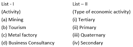
Match the List - I with List - II and select the correct answer from the code given below :
Detailed Solution for APSET Paper 2 Mock Test - 2 (Geography) - Question 5
  • The Primary activities are dependent totally on the nature and natural resources. This includes agriculture, mining, quarrying, fishing, etc.
  • The secondary economic activities process and produce finished output from the natural resources or raw materials from primary activities. These include factories of different kinds like metal and food processing.
  • The tertiary activities are activities that contribute to transport of the goods and services produced by secondary sector. This is service sector which includes activities like transport, tourism, etc.
  • Quaternary activities are based on skills of people. It includes knowledge-oriented activities like business consultancy, information technology, media, etc.

Thus, the correct answer is A.

APSET Paper 2 Mock Test - 2 (Geography) - Question 6
Consider the following statement about trade and growth and state which of them is true?

i. In the last century, the world economy has experienced positive economic growth.

ii. There is a visible direct relationship between the GDP and the trade growth.

Detailed Solution for APSET Paper 2 Mock Test - 2 (Geography) - Question 6

Over the last couple of centuries, the world economy has experienced sustained positive economic growth, and over the same period , this process of economic growth has been accompanied by even faster growth in global trade. Also the country level data has a positive correlation between GDP and trade growth.

APSET Paper 2 Mock Test - 2 (Geography) - Question 7
Consider the following statements:

a. Flow maps tell us what is flowing or being migrated

b. It tells us about the direction of the movement

c. Flow maps give a general information about what is flowing and how it is flowing

d. Flow maps also tell us about the speed at which the flow occurs.

Which of the above statements are correct?

Detailed Solution for APSET Paper 2 Mock Test - 2 (Geography) - Question 7

These are the most important forms of dynamic maps in which the movement of goods, information and people between and among places are shown. The flow maps are used to show the movement of almost anything such as people, products and natural resources. The actual route of movement on a map is considered and the quantitative impression is conveyed by the width of the line.

Speed at which the flow is occurring can also be shown with the help of flow maps, but they are a totally different thing. These are known as speed flow maps or isochronic cartograms. General flow maps do not show the speed.

Thus, the Correct answer is C.

APSET Paper 2 Mock Test - 2 (Geography) - Question 8

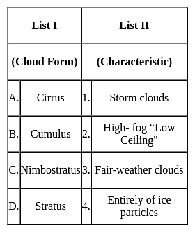
Match List I with List II and select the correct answer using the code given below the Lists :
Detailed Solution for APSET Paper 2 Mock Test - 2 (Geography) - Question 8

The correct answer is option 3.

Key Points

  • Cirrus clouds
    • Formed at high altitudes (8,000 - 12,000m). 
    • They are thin and detached clouds having a feathery appearance.
    • They are always white in color.
    • Cirrus clouds are delicate, feathery clouds that are made mostly of ice crystals.
    • Their wispy shape comes from wind currents which twist and spread the ice crystals into strands.
  • Cumulus
    • ​Formed at a height of 4,000 - 7,000 m.
    • They can appear as low as 300ft above the ground.
    • They exist in patches and can be seen scattered here and there.
    • These clouds look like fluffy, white cotton balls in the sky. They have a flat base
  • Nimbostratus
    • Nimbus is known as a rainstorm within the Latin language.
    • Low-level Clouds, resulting from thickening Altostratus.
    • These are dark, gray clouds that seem to fade into falling rain or snow.
    • They are so thick that they often blot out the sunlight.
  • Stratus
    • These are low Clouds (less than 6,500 feet).
    • These are layered clouds covering large portions of the sky. 
    • Stratus clouds often look like thin, white sheets covering the whole sky. Since they are so thin, they seldom produce much rain or snow.
    • Sometimes, in the mountains or hills, these clouds appear to be fog.

​​Hence, the correct answer is option 3.

APSET Paper 2 Mock Test - 2 (Geography) - Question 9

Which of the following statements about minerals are correct?

(A) Minerals are created by natural processes without any human interference

(B) Mica and chromite are nonferrous minerals

(C) Minerals lying at shallow depths are taken out through open cast mining

(D) Minerals are a non-renewable resource

Detailed Solution for APSET Paper 2 Mock Test - 2 (Geography) - Question 9

A naturally occurring substance that has a definite chemical composition is a mineral.Important Points

  • Minerals are formed in different types of geological environments, under varying conditions
  • They are created by natural processes without any human interference.
  • They can be identified on the basis of their physical properties such as colour, density, hardness and chemical property such as solubility.
  • on the basis of composition, minerals are classified mainly as metallic and non-metallic minerals.
  • Metallic minerals contain metal in raw form. Metals are hard substances that conduct heat and electricity and have a characteristic lustre or shine. Iron ore, bauxite, manganese ore
    • Metallic minerals may be ferrous or non-ferrous.
    • Ferrous minerals like iron ore, manganese and chromite contain iron
    • A non-ferrous mineral does not contain iron but may contain some other metal such as gold, silver, copper or lead.
  • Non-metallic minerals do not contain metals. Limestone, mica and gypsum are examples of such minerals. The mineral fuels like coal and petroleum are also non-metallic minerals.
  • Minerals can be extracted by mining, drilling or quarrying.
  • Minerals are considered nonrenewable because they take a very long time to form (millions of years). This implies that once they are used up, they cannot get back within a short period.
  • The process of taking out minerals from rocks buried under the earth’s surface is called mining. Minerals that lie at shallow depths are taken out by removing the surface layer; this is known as open-cast mining.
  • Minerals occur in different types of rocks. Some are found in igneous rocks, some in metamorphic rocks while others occur in sedimentary rocks.

So, the above points shows that A, C, and D satisfy the minerals.

APSET Paper 2 Mock Test - 2 (Geography) - Question 10
The Red Data Book which lists the endangered species is maintained by which of the following organisation?
Detailed Solution for APSET Paper 2 Mock Test - 2 (Geography) - Question 10

The Red Data Book which lists the endangered species is maintained by IUCN.

Important Points

The International Union for Conservation of Nature (IUCN) maintains the Red List of Threatened Species, also known as the Red Data Book. This list is the world's most comprehensive inventory of the global conservation status of plant and animal species.

Red Data Books:

  • The "Red Data Books" published by the International Union for Conservation of Nature and Natural Resources (IUCN) is the world's most comprehensive inventory of the global conservation status of plant and animal species.
  • A red data book is beneficial for providing detailed information for studies and research. It also helps in monitoring programs on rare and endangered species. It thus helps in protecting the species that are on the verge of extinction
  • IUCN is a network of environmental organizations founded as the International Union for the Protection of Nature in October 1948 in Fontainebleau, France.
  • It promotes nature conservation and the ecologically sustainable use of natural resources.
  • It changed its name to the International Union for Conservation of Nature and Natural Resources (IUCN) in 1956.
  • IUCN is composed of both government and civil society organizations which harness the experience, and resources.
  • Headquarters: Gland, Switzerland.
  • The IUCN maintains the IUCN Red List of Threatened Species, which was established in 1964.
  • IUCN also played a fundamental role in the creation of key international conventions, including the Ramsar Convention on Wetlands (1971), the World Heritage Convention (1972), the Convention on International Trade in Endangered Species, (1974), and the Convention on Biological Diversity (1992), UNFCCC, etc.
  • Caring for the Earth was published by the three organizations in the run-up to the 1992 Earth Summit.

Additional Information

UNO: The United Nations Organization (UNO)

  • It is an intergovernmental organization that was established in 1945 after World War II to promote international peace, security, and cooperation.
  • It is composed of member states from around the world and has various specialized agencies, programs, and funds that work on a wide range of issues, including human rights, economic development, health, and the environment.

WHO: The World Health Organization (WHO)

  • It is a specialized agency of the United Nations that is concerned with international public health.
  • It was established in 1948 and is responsible for providing leadership on global health matters, shaping the health research agenda, setting norms and standards, articulating evidence-based policy options, and monitoring and assessing health trends.

WWF: The World Wildlife Fund (WWF)

  • It is an international conservation organization that works to protect the environment and endangered species.
  • It was established in 1961 and has worked to protect biodiversity, conserve natural habitats, reduce pollution and wasteful consumption, and promote sustainable development.
  • The WWF operates in over 100 countries and has been instrumental in the creation of protected areas and the conservation of endangered species, such as pandas, tigers, and elephants.
APSET Paper 2 Mock Test - 2 (Geography) - Question 11

Consider the following facts about the population of Scheduled Tribes:

1. The total population of Scheduled Tribes accounts for about 8% of the total population of the country.

2. Majority of the Scheduled tribe population live in rural areas and their population is around 10% of the total rural population of the country.

3. The share of the Scheduled Tribe population in urban areas is a meager 5%.

Which of the above is/are correct?
Detailed Solution for APSET Paper 2 Mock Test - 2 (Geography) - Question 11
  • The total population of Scheduled Tribes is 84,326,240 as per the Census 2011 which accounts for 8.2% of the total population of the country.
  • Majority of the Scheduled tribe population live in rural areas and their population is 10.4% of the total rural population of the country.
  • The share of the Scheduled Tribe population in urban areas is a meager 2.4%.
  • Madhya Pradesh, Maharashtra, Orissa, Gujrat, Rajasthan, Jharkhand, Chhattisgarh, Andhra Pradesh, West Bengal, and Karnataka are the states having larger number of Scheduled Tribes.
  • These states account for 83.2% of the total Scheduled Tribe population of the country.
  • Assam, Meghalaya, Nagaland, Jammu & Kashmir, Tripura, Mizoram, Bihar, Manipur, Arunachal Pradesh, and Tamil Nadu, account for another 15.3% of the total Scheduled Tribe population. The share of the remaining states / UTs is negligible.
APSET Paper 2 Mock Test - 2 (Geography) - Question 12

Which country produces the most fish?

Detailed Solution for APSET Paper 2 Mock Test - 2 (Geography) - Question 12

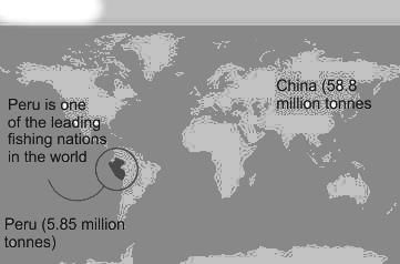
The Correct Answer is Peru

Key Points

  • Peru
    • Peru is placed 4th in our list of fish-producing countries.
    • This country produces 5,854,233 metric tons of fish annually.
    • This country has been a leading producer of fish since 1960, although fish production has declined recently due to overfishing even led to the extinction of some species.
    • Peru is blessed with a 3000 km coastline and 12,000 lakes and lagoons that hosts over 50 species of fishes.
    • The fish industry in Peru is one of the major sources of income for a majority of people.
  • Its nutrient-rich environment supports the world's largest fishery.
  • Top 5 countries of fish production:
    • China (58.8 million tonnes)
    • India (9.46 million tonnes)
    • Indonesia (6.10 million tonnes)
    • Peru (5.85 million tonnes)
    • US (5.36 million tonnes)

Additional Information

  • Aquaculture
    • Aquaculture simply means farming in water. It is the breeding, rearing, and harvesting of fish, shellfish, algae, and other sea animals in all types of water environments for human consumption.
  • China
    • China tops our list as the largest fish-producing country in the world, with an annual production of 58.8 million metric tons.
    • This country has been consistent and remained in its position as the global leader in fish production for the past few years with no competition.
    • In fact, China accounts for the 1/3 of world's total fish production.
APSET Paper 2 Mock Test - 2 (Geography) - Question 13
Who  emphasized the point that geography is not a dry gazetteer of names of places, rivers, mountains, and trade routes?
Detailed Solution for APSET Paper 2 Mock Test - 2 (Geography) - Question 13

The correct answer is C. Ritter.
Key Points

  • German geographer Carl Ritter is commonly associated with Alexander von Humboldt as one of the founders of modern geography.
  • However, most acknowledge Ritter's contributions to the modern discipline to be somewhat less significant than those of von Humboldt, especially as Ritter's life work was based on the observations of others.
  • Ritter, in his class lectures, emphasized the point that geography is not a dry gazetteer of names of places, rivers, mountains, and trade routes.
  • It is a subject of great importance that deals with man and nature’s interrelationship. 
  • He developed the concept of “unity in diversity.” Ritter was chiefly concerned with studies of human geography.
  • He believed, as did Vidal de la Blache much later, that earth and its inhabitants stand in the closest reciprocal relations, and one cannot be truly presented in all its relationships without the other.
  • Hence history and geography must always remain inseparable.
  • Land affects the inhabitants and the inhabitants of the land. In simple words, every naturally bounded area is united in respect of climate, production, culture, population, and history.
APSET Paper 2 Mock Test - 2 (Geography) - Question 14

Identify the rightly matched pairs:

1. Selvas - Amazon tropical rainforest

2. Prairies - Grasslands of Argentina and Uruguay

3. Pampas - Grasslands of North America

Select the correct answer from the options given below.
Detailed Solution for APSET Paper 2 Mock Test - 2 (Geography) - Question 14
  • The hot wet equatorial climate supports a luxuriant type of vegetation – the tropical rainforest. The Amazon tropical rain forest is known as Selvas.
  • It comprises a multitude of evergreen trees that yield tropical hardwood, e.g. mahogany, ebony, greenheart, cabinet wood. Lianas, epiphytic and parasitic plants are also found. Trees of a single species are very scarce in such vegetation.
  • Bordering the deserts, away from the Mediterranean regions and in the interior continents are the temperate grasslands.
  • Though they lie in the Westerly wind belt, they are so remote from maritime influence that the grasslands are practically treeless.
  • These grasslands are so distinctive in their natural vegetation that, although those which occur in the southern hemisphere have a much more moderate climate, they are often dealt with together.
  • In the northern hemisphere, the grasslands are far more extensive and are entirely continental.
  • In Eurasia, they are called the Steppes and stretch eastwards from the shores of the Black Sea across the Great Russian plain to the foothills of the Altai Mountains, a distance of well over 2,000 miles.
  • There are isolated sections in the Pustaz of Hungary and the plains of Manchuria.
  • In North America, the grasslands are also quite extensive and are called Prairies. They lie between the foothills of the Rockies and the Great Lakes astride the American Canadian border.
  • In the case of the Pampas of Argentina and Uruguay, the grasslands extend right to the sea and enjoy much maritime influence.
  • In South Africa, the grasslands are sandwiched between the Drakensberg and the Kalahari Desert; and are further subdivided into the more tropical Bushveld in the north, and the more temperate HighVeld in the south.
APSET Paper 2 Mock Test - 2 (Geography) - Question 15
Read the following statements. Which of them are true? Select your answer from the code given below:

(a) The khaddar soils are found in the low areas of valley bottom of the North Indian plains.

(b) The black regur soils are found in the Deccan plateau.

(c) The tarai region is area in the Deccan plateau.

(d) The foothills of Sahyadris have bhabar soils.

Detailed Solution for APSET Paper 2 Mock Test - 2 (Geography) - Question 15

 The khaddar soils are pale brown, sandy clays and loams. They are found in the lower areas of valley bottoms of North Indian plains. Black regur soils made of the basaltic rock are found in the Deccan plateau. The tarai region is the area swampy lowland of the north Indian plain, just below the Himalayas is called tarai tract. The foothills of Shiwaliks have the bhabar soils.

APSET Paper 2 Mock Test - 2 (Geography) - Question 16

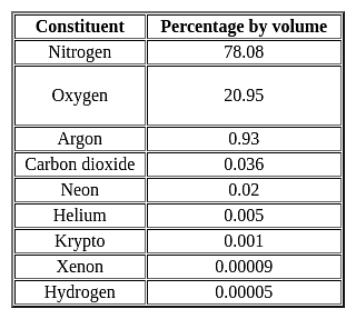
Major constituent gasses of the atmosphere are _____________.

Detailed Solution for APSET Paper 2 Mock Test - 2 (Geography) - Question 16

Atmosphere: The earth is surrounded by a layer of gas called the atmosphere. This thin blanket of air is an integral and important aspect of the planet.

Key-Points

Gaseous composition of the atmosphere:

  • The air in the atmosphere is a mixture of many gases like nitrogenoxygen, carbon dioxide, and water vapors.
  • The atmosphere is composed mainly of nitrogen and oxygen
  • Nitrogen and oxygen are two gases that make up the bulk of the atmosphere.
  • Carbon dioxide, helium, ozone, argon, and hydrogen are found in lesser quantities.
  • Nitrogen is the most plentiful gas in the air. It comprises 78% of the total composition of air.
  • Oxygen holding the second position by volume constitutes 21% of the atmosphere.

Hence, option 2 is the correct answer.

Important Point

APSET Paper 2 Mock Test - 2 (Geography) - Question 17
The formula for crop combination mentioned below was given by


Detailed Solution for APSET Paper 2 Mock Test - 2 (Geography) - Question 17

Rafiullah is devised a crop combination method in 1965 in order to improve the crop combination method by Weaver. He D is represents D deviation, Dp is positive difference and Dn is negative difference and N is number of crops.

Thus, the correct answer is A.

APSET Paper 2 Mock Test - 2 (Geography) - Question 18
The thickness of the Troposphere is maximum at the Equator during which of the following seasons?
Detailed Solution for APSET Paper 2 Mock Test - 2 (Geography) - Question 18

The correct answer is Summer.

Key Points

  • The Troposphere is the lowest layer of the atmosphere.
  • It extends up to an height of 20 km.
  • The height of the Troposphere varies from the equator to the poles.
  • its height varies with latitude and seasons.
  • Its height is lower in the winter and highest in the summer.
  • It can be as high as 20 km near the Equator and as low as 7 km at the poles.
  • Therefore, the thickness of the Troposphere is maximum at the Equator during summer season.

 Thus, we can say that the thickness of the Troposphere is maximum at the Equator.

APSET Paper 2 Mock Test - 2 (Geography) - Question 19
Which one of the following is not a result of erosion by running water?
Detailed Solution for APSET Paper 2 Mock Test - 2 (Geography) - Question 19

The correct answer is Natural levees.Key Points

  • Natural levees are a depositional feature found along the banks of large rivers.
  • These are ridges of coarse deposits lying parallel to the river.

Important Points

  • Valleys are formed due to erosion by the river.
    • The river widens and deepens the floor to make valleys.
  • A canyon is a kind of valley that is wide at its top than at its bottom.
    • These are formed in horizontal bedded sedimentary rocks.

Additional Information

  • Other erosional features made by running water are:
    • Gorges, potholes, plunge pools, river terraces.
  • Other depositional features made by running water are:
    • ​Alluvial fans, deltas, floodplains, point bars, meanders, oxbow lake.
APSET Paper 2 Mock Test - 2 (Geography) - Question 20
During the time of perigee the tidal range is -
Detailed Solution for APSET Paper 2 Mock Test - 2 (Geography) - Question 20

The correct answer is greater than normal.

Key Points

  • Perigee is when the moon is closest to the Earth.
  • Once every 28 days, the moon reaches a 'perigee'.
  • This is the point at which the moon's gravitational pull is the strongest.
  • During these periods, there will be an increase in the average range of tides.
  • Tides are the rise and fall of sea levels caused by the combined effects of the gravitational forces exerted by the moon and Sun and the rotation of the Earth.

 Thus, we can say that during the time of perigee, the tidal range is greater than normal.

Additional Information

  • 14 days after perigee, the moon reaches an 'apogee', this is the point when the moon is the farthest from Earth.
  • During this period, there is a decrease in the average range of tides.
APSET Paper 2 Mock Test - 2 (Geography) - Question 21
The rate of decrease of temperature in the troposphere is :
Detailed Solution for APSET Paper 2 Mock Test - 2 (Geography) - Question 21

The correct answer is 6.4°C.

Key Points

  • The troposphere, the lowest layer of Earth's atmosphere.
  • The troposphere is warmest at the bottom near Earth's surface.
  • The troposphere is coldest at its top, where it meets up with the layer above (the stratosphere) at a boundary region called the tropopause.
  • Temperatures drop as you move upward through the troposphere
  • The temperature drops about 6.5° C with each increase in altitude of 1 kilometer.
  • The rate at which the temperature changes with altitude is called the "lapse rate".
  • In the standard atmosphere, by the time you reach the top of the troposphere the temperature has fallen to a chilly -57° C.
  • In the layer above the troposphere, the stratosphere, temperature rises with increasing altitude.
  • In the stratosphere, the air is heated from above by ultraviolet "light" which is absorbed by ozone molecules in the air.
  • The tropopause is the boundary between the troposphere and the stratosphere.
  • The tropopause occurs where the temperature stops dropping with increasing altitude (in the troposphere) and begins climbing with increasing altitude (the stratosphere).
APSET Paper 2 Mock Test - 2 (Geography) - Question 22
Which of the following is not a component of Population change?
Detailed Solution for APSET Paper 2 Mock Test - 2 (Geography) - Question 22

Components of Population Change

  • There are three components of population change – Births, Deaths and Migration.
  • Crude Birth Rate (CBR) is expressed as the number of live births in a year per thousand of population.
  • Crude Death Rate (CDR) is expressed in terms of the number of deaths in a particular year per thousand of population in a particular region.

Migration

  • When people move from one place to another, the place they move from is called the Place of Origin and the place they move to is called the Place of Destination.
  • The place of origin shows a decrease in population while the population increases in the place of destination.
APSET Paper 2 Mock Test - 2 (Geography) - Question 23

Solifluction is a geomorphic process involving a special type of soil flow that is noticed in

Detailed Solution for APSET Paper 2 Mock Test - 2 (Geography) - Question 23

The correct answer is permafrost regions.

Key Points

  • Solifluction refers to the progressive movement of a mass down a slope ("mass wasting") as a result of the freeze-thaw activity. Hence option 3 is correct.
  • It can also be defined as a type of creep that occurs in cold regions or at high elevations and occurs when the mass of saturated rock waste flows down the slope.
  • The slow downslope movement of the surface rocks is referred to as soil creep.
  • It's both a continuous process and a surface phenomenon that happens on slopes.

Hence option 3 is correct.

APSET Paper 2 Mock Test - 2 (Geography) - Question 24
Consider the following statements about thematic map:

a. A special purpose map

b. Communicates geographical relationships

c. Shows single or multiple themes of a study

d. Depicts surface features of an area.

Which of the statements above are correct?

Detailed Solution for APSET Paper 2 Mock Test - 2 (Geography) - Question 24

The Thematic Maps are special category maps designed to show a particular theme with a specific geographic area and portray spatial variations of a single phenomenon or the relationship between phenomena prevalent at particular locations. The main purposes of thematic maps are to provide specific information about locations, provide general information about spatial patterns and can be used for comparing patterns on two or more maps. The General maps portray the surface features or data such as landforms, lines of transportation, settlements but the thematic maps show the most required thing i.e., spatial variation. Maps showing population density, climate natural vegetation are some examples of thematic maps.

Thus, the Correct answer is B.

APSET Paper 2 Mock Test - 2 (Geography) - Question 25

Palk Strait separates India from

Detailed Solution for APSET Paper 2 Mock Test - 2 (Geography) - Question 25

Palk Strait separates India from Sri Lanka. Palk Strait, inlet of the Bay of Bengal between southeastern India and northern Sri Lanka. It is bounded on the south by Pamban Island (India), Adam’s (Rama’s) Bridge (a chain of shoals), the Gulf of Mannar, and Mannar Island (Sri Lanka).

APSET Paper 2 Mock Test - 2 (Geography) - Question 26

A geographer is analyzing global trade routes in the era of sailing ships. Which of the following two essential elements of geography would likely form the conceptual bases of the geographer's study?

Detailed Solution for APSET Paper 2 Mock Test - 2 (Geography) - Question 26

This question requires the examinee to demonstrate knowledge of the six essential elements of geography (i.e., the world in spatial terms, places and regions, physical systems, human systems, human-environment interactions, and the uses of geography). Analyzing global trade routes in the era of sailing ships requires an understanding of the patterns and networks of economic interdependence across Earth's surface. Such networks are a major feature of the essential geographic element of human systems. An examination of global trade routes during this period also involves an analysis of the world in spatial terms, the relationships across space between people, places, and environments.

APSET Paper 2 Mock Test - 2 (Geography) - Question 27

Select the correct option(s) for the statement from the codes given below:

A region is more diverse culturally if it:

(a) has homogeneous population composition

(b) has heterogeneous population composition.

(c) receives voluminous in migration.

(d) is geographically isolated.

Detailed Solution for APSET Paper 2 Mock Test - 2 (Geography) - Question 27

The correct answer is Only (b) and (c).

Key Points

  • Cultural diversity is the quality of diverse or different cultures, as opposed to monoculture, the global mono-culture, or a homogenization of cultures, akin to cultural decay.
  • The phrase cultural diversity can also refer to having different cultures respect each other's differences. The phrase "cultural diversity" is also sometimes used to mean the variety of human societies or cultures in a specific region, or the world as a whole.
  • This defined cultural diversity as "the set of distinctive spiritual, material, intellectual and emotional features of society or a social group", including lifestyles, value systems, traditions, and beliefs.
  • The world's population comprises people from different cultures, Therefore, in a culturally diversified society, society includes people from multiple cultures, and it has heterogeneous population composition. with each culture being a product of individual development.
  • Individual development refers to the historical development of the culture, the people involved, their social behavior, and how the population merged or moved to their current society.
  • The cultural diversity that accompanies migration enables new perspectives and experiences to be exchanged through intercultural encounters; it allows for creative and hybrid cultural practices to emerge; and it creates a general societal openness to difference and to change.

Additional Information

The world is naturally multicultural. Approaching cultural diversity with a mindset and actions that embrace this fact leads to many benefits, like

  • Compassion: Communication and understanding of differences lead to increased compassion instead of judgment.
  • Innovation: Varied perspectives and lenses of looking at the world lend to innovative thinking.
  • Productivity: People who come together and bring their style of working together tend to support a more productive team.
  • New Opportunities: Diversity opens the door to new opportunities and the blending of ideas that would otherwise have been homogeneous.
  • Problem-Solving: Challenges are layered, so having people with different backgrounds can lead to better problem-solving with a richness of opinions.
APSET Paper 2 Mock Test - 2 (Geography) - Question 28

Which of the following is not among the four coral reef regions of India identified by the Government for intensive conservation and management?

Detailed Solution for APSET Paper 2 Mock Test - 2 (Geography) - Question 28

The Gulf of Khambhat, also known as the Gulf of Cambay, is a bay on the Arabian Sea coast of India, bordering the state of Gujarat.

APSET Paper 2 Mock Test - 2 (Geography) - Question 29

The following pairs are given about the contribution of geographer's in Agricultural geography and find out which is not correct?
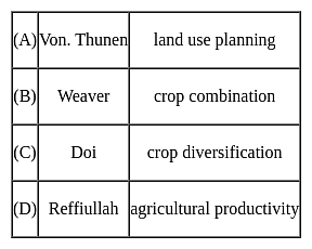
Detailed Solution for APSET Paper 2 Mock Test - 2 (Geography) - Question 29

The correct answer is D.

Key Points

  • Von Thunen conceived the idea of a land-use model in both urban and rural landscapes around a city on an isotropic landscape. His idea is basically how economic rent decreases from the center of a city to its periphery. His system of land use around a city with no trade alliance with any other country is ring-shaped.
  • In the field of agricultural geography, Weaver (1954) was the first to use statistical techniques for the demarcation of crop combination regions of the Middle West (USA). In his attempt to demarcate the agricultural regions of the Middle West (USA), Weaver based his analysis on acreage statistics.
  • Crop diversification refers to the addition of new crops or cropping systems to agricultural production on a particular farm taking into account the different returns from value-added crops with complementary marketing opportunities. Crop diversification is a concept that is opposite to crop specialization. Farmers all over the world, especially in developing countries, try to grow several crops in their holdings in an agricultural year. For the measurement of crop diversification, Doi and Bhatia (1965) developed a formula based on the gross cropped area.
  • There are several ways to measure crop diversification, and the most important include Herfindahl Index, Simpson Diversity Index, Ogive Index, Margalef Index, Shannon Index, Berger-Parker Index, and Entropy Index.
  • Jasbir Singh has proposed a unique method for the measurement of Agricultural Productivity which is in terms of monetary value earned from agriculture per capital-labor employed.
  • He proposed that agricultural productivity is the summation of the product of the output of production of the crop and its market price, from which the cost of production is subtracted. Agricultural Productivity= ∑( Pij*Mij)-Cop- Here P is output or production in quantity of the crop, M is the Market price and Cop is the cost of Production.
APSET Paper 2 Mock Test - 2 (Geography) - Question 30

According to the data, released by housing and urban poverity alleviation ministry, which state has the maximum number of slums?

Detailed Solution for APSET Paper 2 Mock Test - 2 (Geography) - Question 30

According to Census 2011, Maharashtra has highest number of slum blocks in the Country. According to ministry reports out of 1 lakh slum blocks 21,000 lies in Maharashtra.

View more questions
60 tests
Information about APSET Paper 2 Mock Test - 2 (Geography) Page
In this test you can find the Exam questions for APSET Paper 2 Mock Test - 2 (Geography) solved & explained in the simplest way possible. Besides giving Questions and answers for APSET Paper 2 Mock Test - 2 (Geography), EduRev gives you an ample number of Online tests for practice

Top Courses for AP TET

Download as PDF

Top Courses for AP TET