AP TET Exam  >  AP TET Tests  >  APSET Mock Test Series 2025  >  APSET Paper 2 Mock Test - 6 (Geography) - AP TET MCQ

APSET Paper 2 Mock Test - 6 (Geography) - AP TET MCQ


Test Description

30 Questions MCQ Test APSET Mock Test Series 2025 - APSET Paper 2 Mock Test - 6 (Geography)

APSET Paper 2 Mock Test - 6 (Geography) for AP TET 2024 is part of APSET Mock Test Series 2025 preparation. The APSET Paper 2 Mock Test - 6 (Geography) questions and answers have been prepared according to the AP TET exam syllabus.The APSET Paper 2 Mock Test - 6 (Geography) MCQs are made for AP TET 2024 Exam. Find important definitions, questions, notes, meanings, examples, exercises, MCQs and online tests for APSET Paper 2 Mock Test - 6 (Geography) below.
Solutions of APSET Paper 2 Mock Test - 6 (Geography) questions in English are available as part of our APSET Mock Test Series 2025 for AP TET & APSET Paper 2 Mock Test - 6 (Geography) solutions in Hindi for APSET Mock Test Series 2025 course. Download more important topics, notes, lectures and mock test series for AP TET Exam by signing up for free. Attempt APSET Paper 2 Mock Test - 6 (Geography) | 100 questions in 120 minutes | Mock test for AP TET preparation | Free important questions MCQ to study APSET Mock Test Series 2025 for AP TET Exam | Download free PDF with solutions
APSET Paper 2 Mock Test - 6 (Geography) - Question 1

Identify the option that arranges the following states' literacy rates in descending order, according to Census 2011.

A. Kerala

B. Himachal Pradesh

C. Haryana

Detailed Solution for APSET Paper 2 Mock Test - 6 (Geography) - Question 1
The correct answer is (A), (B), (C).
Key Points
  • According to Census 2011, the literacy rates of the states in descending order are Kerala, Himachal Pradesh, and Haryana.
  • Kerala has the highest literacy rate of 94% among all the states in India.
  • Haryana has a literacy rate of 75.6%.
  • Himachal Pradesh has a literacy rate of 82.80%.

Additional Information

  • The Indian Census is the largest single source of a variety of statistical information on different characteristics of the people of India.
  • The first census of India was conducted by Lord Mayo in 1872.
  • The first official census was started by Lord Ripon in 1881.
  • In 2011 it is 15 census of India.
  • It comes to the Ministry of Home Affairs From 1961.
  • The slogan of the 2011 Census is Our Census Our Future.
  • C M Chandramauli was the Registrar General and Census Commissioner of India for the 2011 Indian Census.
APSET Paper 2 Mock Test - 6 (Geography) - Question 2

Consider the following statements about human environment interaction and state which amongst the following is true:

i. The type of society has strong influence over the environment .

ii. Human characteristics have impact on the environment.

iii. Education is a key factor on people’s view of life.

iv. Ecosystem services are important for human well-being.

Choose the correct option from below:

Detailed Solution for APSET Paper 2 Mock Test - 6 (Geography) - Question 2

 Human environment interaction involves understanding of human characteristics. The type of society strongly influences people’s attitude towards nature, their behavior, and therefore their impact on ecosystem. Important characteristics of human social systems are population size, social organization, values, technologies etc.

Thus, the Correct answer is D.

1 Crore+ students have signed up on EduRev. Have you? Download the App
APSET Paper 2 Mock Test - 6 (Geography) - Question 3

Jarawas and Sentinelese tribes are found in which among the following state / Union Territory of India?

Detailed Solution for APSET Paper 2 Mock Test - 6 (Geography) - Question 3

Andaman is home to five "particularly vulnerable" tribes. They are the Jarawas, North Sentinelese, Great Andamanese, Onge and Shompen. The Jarawas and the North Sentinelese haven't integrated with the mainstream population yet.

APSET Paper 2 Mock Test - 6 (Geography) - Question 4
Which country holds the top position in the ICT Development Index (IDI) ranking?
Detailed Solution for APSET Paper 2 Mock Test - 6 (Geography) - Question 4

The IDI ranking is published by United Nations International Telecommunications Union. It is an index which is a composite of ICT indicators. It is recognized all over the world. The leading country in this ranking is Iceland with the index value of 8.98 as of 2017. Switzerland, UK and USA hold third, fifth and sixteenth positions.

Thus, the correct answer is B.

APSET Paper 2 Mock Test - 6 (Geography) - Question 5
Which of the following option is correct in the case of fronts and frontogenesis?
Detailed Solution for APSET Paper 2 Mock Test - 6 (Geography) - Question 5

The term Frontogenesis was first used by Tor Bergeron for the creation of new fronts. Later, it was extended to include the process of regeneration of old and decaying fronts. The term is a Latin derived term. Frontogenesis occurs when the wind blows in such a way that the isotherms become packed along the leading edge of the intruding air mass.

Generally, the isobars in an air mass are smooth curves and there are no sharp bends in them. And frontal activity is always associated with cloudiness and precipitation. Since warm air moves up along the frontal surface, it cools adiabatically and thus results in cloudy condensation and precipitation.

The appearance of warm front is mostly observed by the presence of cirrus clouds.

APSET Paper 2 Mock Test - 6 (Geography) - Question 6
Sir Isaac Newton has improvised on the work of
Detailed Solution for APSET Paper 2 Mock Test - 6 (Geography) - Question 6

Varenius is famous for his book Geographica Generalis. It is divided into three sections of absolute geography, comparative geography and relative geography. It is head as an important addition to the knowledge about comparative and scientific geography. Sir Isaac Newton made a lot of improvisation on the 1672 Cambridge edition of this book.

APSET Paper 2 Mock Test - 6 (Geography) - Question 7
Which of the following method is related with Human geography?
Detailed Solution for APSET Paper 2 Mock Test - 6 (Geography) - Question 7

The correct answer is Both 1 and 2.

Key PointsHuman Geography

  • Human geography uses the full sweep of quantitative and qualitative methods from across the social sciences and humanities, mindful of using them to provide a thorough geographic analysis.
  • It also places emphasis on fieldwork and mapping, and has made a number of contributions to developing new methods and techniques, notably in the areas of spatial analysis, spatial statistics, and GIScience.
  • Quantitative Methods in Geography will be composed of lectures, discussions and exercises and is designed as an undergraduate level introduction to spatial analysis and the application of statistical methods in a spatial context.
  • Qualitative method is the collection of information about human behaviour and perception. It is about focusing in depth to find out why and how certain activities and events occur.
APSET Paper 2 Mock Test - 6 (Geography) - Question 8
Which of the following statements is NOT correct regarding the rabi crops?
Detailed Solution for APSET Paper 2 Mock Test - 6 (Geography) - Question 8

The correct answer is Southern and southeastern states are important for the production of wheat and other rabi crops.

Key Points

  • Punjab, Haryana, Uttar Pradesh, and Madhya Pradesh, are major contributors to the production of wheat, barley, and other rabi crops. Hence Option 1 is incorrect.
  • These regions have favorable climatic conditions and fertile soil, making them suitable for the cultivation of rabi crops.
  • Wheat is one of the most important rabi crops grown in these states, and they significantly contribute to the overall wheat production in the country.
  • Other rabi crops like barley, peas, gram, and mustard are also cultivated in these regions.

Additional Information

  • Kharif crops
    • Kharif Crops are planted at the onset of the South-West monsoon, primarily in India, Pakistan, and Bangladesh, during the rainy season.
    • The sowing of these crops takes place between the months of June and July.
    • Upon reaching maturity, typically in October, these crops are harvested in the Autumn season.
    • Examples of Kharif crops include rice, cotton, corn, sugarcane, turmeric, pigeon pea, and more.
  • Zaid crops
    • Zaid Crops are grown during the summer season in regions with a tropical climate.
    • These crops are typically cultivated between the months of March and June.
    • Zaid crops are known for their quick growth and shorter duration compared to Kharif and Rabi crops.
    • Examples of Zaid crops include cucumber, watermelon, bitter gourd, maize, and cowpea.
    • These crops are often irrigated using modern techniques and are harvested before the onset of the monsoon season.
APSET Paper 2 Mock Test - 6 (Geography) - Question 9
Consider the following statements:-

a) Sea level Changes are only affected by Eustatic changes.

b) Marine sediments depict about global sea level change.

c) Evidences of sedimentary deposits of various sorts depict sea level changes during the pre-quaternary stages.

d) Sea level has risen by about 10 to 16 cm in the past 100 years.

Which of the following statements is correct?

Detailed Solution for APSET Paper 2 Mock Test - 6 (Geography) - Question 9

The sea level changes are not only affected by eustatic changes such as the melting of ice and global warming but also by tectonic changes such as Isostatic changes, epeirogenetic and orogenetic changes. Various other evidences such as elevated shorelines, the deposition of organic and inorganic deposits in the continental shelves support the sea level changes. But recently, the change in the sea level has mostly been due to the factors such as global warming due to anthropogenic conditions and melting of glaciers and ice sheets.

APSET Paper 2 Mock Test - 6 (Geography) - Question 10

A medical geographer researching the spatial distribution of asthma among children 12–17 years of age in a major U.S. city hypothesizes that there is a link between poverty and the prevalence of the disease. Which of the following research strategies would best enable the geographer to explore that hypothesis?

Detailed Solution for APSET Paper 2 Mock Test - 6 (Geography) - Question 10

This question requires the examinee to demonstrate knowledge of sources of geographic information, characteristics and uses of geographic systems, and geographic tools and technologies. Geographic information systems, which digitally create spatial areas, use sophisticated software to organize, manipulate, and analyze diverse forms of geographic data. Such a system would be a particularly effective means of correlating places of asthma occurrence with the socioeconomic characteristics of those places to determine whether there is a link between poverty and the prevalence of the disease.

APSET Paper 2 Mock Test - 6 (Geography) - Question 11
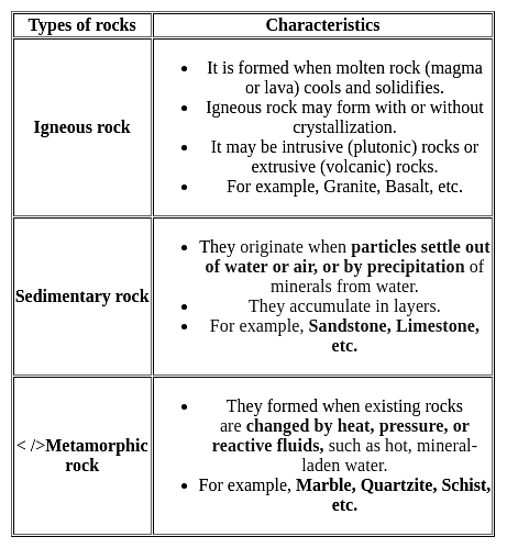
Which of the following is a metamorphic rock?
Detailed Solution for APSET Paper 2 Mock Test - 6 (Geography) - Question 11

The Correct is Gneiss.

 Key Points

  • Gneiss usually forms by regional metamorphism at convergent plate boundaries.
  • It is a high-grade metamorphic rock in which mineral grains recrystallized under intense heat and pressure

 Important Points

  • Basalt is a dark-colored, fine-grained, igneous rock composed mainly of plagioclase and pyroxene minerals.
  • Syenite is an intrusive igneous rock composed of feldspar and a ferromagnesian mineral.
  • Chemically, syenites contain a moderate amount of silica, relatively large amounts of alkalies, and alumina.
  • Sandstone is a sedimentary rock composed mostly of quartz sand.
  • Sandstone that contains more than 90% quartz is called quartzose sandstone.
  • When the sandstone contains more than 25% feldspar, it is called arkose or arkosic sandstone.

Additional Information


APSET Paper 2 Mock Test - 6 (Geography) - Question 12
Read the following statements and select the correct answer from the code given below:

(a) The satellite towns are a part of the main city’s municipal corporation.

(b) The satellite towns develop beyond city’s green belt.

(c) The satellite towns are totally dependent upon the main city area.

(d) The satellite towns are separated from the main city physically by a geographical barrier like river.

Code:

Detailed Solution for APSET Paper 2 Mock Test - 6 (Geography) - Question 12

The Satellite towns have a working administrative body of their own, generally municipalities. These towns have at least partial social and economic independence, but commute to city for is common. These areas develop beyond city’s green belt and have a geographical barrier like river which separated the satellite town as a separate, but somewhat dependent entity from the main city.

Thus, the correct answer is C.

APSET Paper 2 Mock Test - 6 (Geography) - Question 13
Cape Agulhas makes the dividing point between which of the two oceans?
Detailed Solution for APSET Paper 2 Mock Test - 6 (Geography) - Question 13

The correct answer is The Atlantic Ocean and the Indian Ocean. Key Points

  • Cape Agulhas is a rocky headland in Western Cape, South Africa. It is the geographic southern tip of the African continent
  • It is the beginning of the dividing line between the Atlantic and Indian Oceans according to the International Hydrographic Organization.
  • This is the place where the warm-water Agulhas current of the Indian Ocean meets the cold-water Benguela current of the Atlantic Ocean and turns back on itself.

Additional Information

  • The Pacific Ocean is the largest and deepest of Earth's five oceanic divisions. It extends from the Arctic Ocean in the north to the Southern Ocean in the south and is bounded by the continents of Asia and Oceania in the west and the Americas in the east.
  • The Atlantic Ocean is the second-largest of the world's five oceans, with an area of about 106,460,000 km². It covers approximately 20% of Earth's surface and about 29% of its water surface area.
  • The Indian Ocean is the third-largest of the world's five oceanic divisions. The shape of ocean is almost triangular. In the north, it is bound by Asia, in the west by Africa and in the east by Australia.
  • The Arctic Ocean is the smallest and shallowest of the world's five major oceans. It spans an area of approximately 14,060,000 km² and is known as the coldest of all oceans. 

Thus, Cape Agulhas makes the dividing point between The Atlantic Ocean and the Indian Ocean.

APSET Paper 2 Mock Test - 6 (Geography) - Question 14

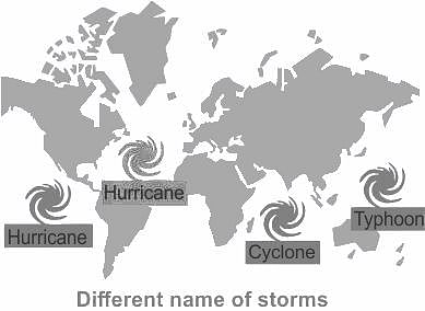
A cyclone is known by different names in different parts of the world. In Philippines it is called as _______.

Detailed Solution for APSET Paper 2 Mock Test - 6 (Geography) - Question 14

The correct answer is a typhoon.

Key Points

  • A cyclone is known by different names in different parts of the world.
  • It is called a 'typhoon’ in Japan and the Philippines.
  • While they are called ‘cyclones’ in the Indian and South Pacific oceans.
  • In the Atlantic Ocean, they are called ‘hurricanes’.

Additional Information

  • Cyclone:
    • A cyclone is a large air mass that rotates around a strong centre of low atmospheric pressure.
    • Cyclones rotate clockwise in the Southern Hemisphere and anti-clockwise in the Northern Hemisphere.
    • Cyclones are rapid inward air circulation around a low-pressure area.
    • Factors like wind speed, wind direction, temperature and humidity contribute to the development of cyclones.
    • Cyclone/Strom is termed by different names in different continents -

Important Points

  • Cyclone is a chain of events that ends with the formation of a very low-pressure system with very high-speed winds revolving around it.
  • The centre of a cyclone is a calm area.
  • It is called the eye of the storm.
  • A large cyclone is a violently rotating mass of air in the atmosphere, 10 to 15 km high.
  • A cyclone is known by different names in different parts of the world.
  • It is called a ‘hurricane’ on the American continent.
  • In the Philippines and Japan, it is called a ‘typhoon’.
  • In Australia it is known as willy - willy.

APSET Paper 2 Mock Test - 6 (Geography) - Question 15

Consider the following statements about Human settlements

1. Conurbation refers to rarely dense rural settlements which are also known as cross-shaped settlements.

2. Conurbations are part of metropolisation which is a process related to the unprecedented physical growth of cities in the fringe areas.

Which of the statements given above is/are correct?

Detailed Solution for APSET Paper 2 Mock Test - 6 (Geography) - Question 15

The correct answer is 2 only.

Key Points

  • The term conurbation was coined by Patrick Geddes in 1915.
  • Conurbation referred to a large area of urban development that resulted from the merging of originally separate towns or cities. Greater London, Manchester, Chicago and Tokyo are examples. Hence statement 1 is incorrect.
  • Conurbations are part of metropolisation which is a process related to the unprecedented physical growth of the city in the fringe areas. Hence, statement 2 is correct.
  • T-shaped, Y-shaped, Cross-shaped or cruciform settlements: T -shaped settlements develop at tri-junctions of the roads while -shaped settlements emerge as the places where two roads converge on the third one and houses are built along these roads.

Additional Information

Types of Urban Settlement-

  • Town
    • The concept of ‘town’ can best be understood with reference to ‘village’. Population size is not the only criterion.
  • City
    • In the words of Lewis Mumford, “ the city is in fact the physical form of the highest and most complex type of associative life”.
  • Conurbation
    • It refers to a large area of urban development that resulted from the merging of originally separate towns or cities. Greater London, Manchester, Chicago and Tokyo are examples.
  • Megalopolis
    • It refers to the union of conurbations.
APSET Paper 2 Mock Test - 6 (Geography) - Question 16
Consider the following statement about Paris agreement:

i. Paris Agreement is known to combat climate change.

ii. Agreement aimed at global green house gas emission reduction.

iii. The conference held in 2015

Choose the correct option from below:

Detailed Solution for APSET Paper 2 Mock Test - 6 (Geography) - Question 16

 Paris agreement is an international agreement to control climate change. From 30 November to 11 November 2015, over 195 nation governments gathered in Paris, France and discussed a possible new global agreement on climate change aimed at reducing global green house gas emission. It is a 32 page agreement with 29 articles widely recognized as a historic deal to stop global warming.

APSET Paper 2 Mock Test - 6 (Geography) - Question 17
How are resources divided on the basis of status of development? 
Detailed Solution for APSET Paper 2 Mock Test - 6 (Geography) - Question 17

The correct answer is Potential, developed, stock, and reserves.

Key Points

  • Resource refers to all the materials available in our environment that help us to satisfy our needs and wants.
  • Resources are classified on the basis of their status of development which includes potential, developed stock, and reserves.
  • Resources can be classified in the following ways–
    • On the basis of origin – biotic and abiotic
    • On the basis of exhaustibility – renewable and non-renewable
    • On the basis of ownership – individual, community, national and international
    • On the basis of the status of development – potential, developed, stock, and reserves.

Additional Information

  •  On the basis of the status of development, resources are classified into four groups, namely potential, developed, stock, and reserve.
    • Potential Resources: Potential resources are those which are found in a region, but have not been utilized. For example, solar energy and wind energy, available in Rajasthan and Gujarat, have not been developed properly.
    • Developed Resources: Developed resources are those that are estimated in terms of their quantity and quality for utilization, e.g., water, soil, and forests.
    • Stock Resources: Materials in the environment that have the potential to satisfy human needs but are not technologically accessible to human beings, e.g., the use of water as a rich source of energy.
    • Reserve Resources: A Reserve is a part of the stock that can be put to use in the near future with the help of existing technology, e.g., water in dams, and forests.
APSET Paper 2 Mock Test - 6 (Geography) - Question 18

In which stage of landscape evolution do relief features become more subdued?

Detailed Solution for APSET Paper 2 Mock Test - 6 (Geography) - Question 18

Answer: Option 2) Mature stage.

Key Points

  • Understanding the stages of landscape evolution is essential for comprehending how landforms change over time.
  • One critical aspect of this evolution is the transformation of relief features, which become more subdued as landscapes progress through various stages.
  • Mature stage: The mature stage represents a transitional phase where relief features begin to become more subdued.
  • While some rugged terrain may still persist, the overall topography becomes gentler, with smoother slopes and less pronounced landforms.
  • Rivers widen their valleys through lateral erosion, and the landscape achieves a more balanced state between erosion and uplift.

Additional Information 

  • Youthful stage: In the youthful stage of landscape evolution, relief features are typically pronounced, characterized by steep slopes, rugged terrain, and prominent landforms such as peaks and valleys. This stage is marked by intense erosion and rapid changes in topography as geological forces sculpt the landscape with vigor.
  • Old age stage: In the old age stage, relief features are significantly subdued, and the landscape exhibits low relief with nearly level surfaces. Rivers meander across broad floodplains, and mountain ranges are reduced to residual hills and isolated remnants. This stage is characterized by extensive erosion, leading to the formation of peneplains—nearly level surfaces eroded to a uniform low elevation.
  • Transitional stage: The transitional stage represents a period of flux between different stages of landscape evolution. Relief features may exhibit characteristics of both youthful and mature stages as the landscape undergoes gradual transformation. This stage is marked by dynamic processes as the landscape adjusts to changing geological and environmental conditions.

Important Points 

  • The transformation of relief features is influenced by a variety of factors, including the type and intensity of erosion, tectonic activity, and climatic conditions.
  • Different landscapes may exhibit variations in the rate and sequence of relief feature modification, depending on their geological history and environmental context.
APSET Paper 2 Mock Test - 6 (Geography) - Question 19
The upper portion of the mantle is called .
Detailed Solution for APSET Paper 2 Mock Test - 6 (Geography) - Question 19

The correct answer is asthenosphere.

Key Points

  • Asthenosphere:
    • The asthenosphere is the denser, weaker layer beneath the lithospheric mantle.
    • It lies between about 100 kilometers (62 miles) and 410 kilometers (255 miles) beneath Earth's surface.
    • The temperature and pressure of the asthenosphere are so high that rocks soften and partly melt, becoming semi-molten.
    • The asthenosphere is generally more viscous than the lithosphere, and the lithosphere-asthenosphere boundary (LAB) is the point where geologists and rheologists, scientists who study the flow of matter mark the difference in ductility between the two layers of the upper mantle.

So, it is clear that the asthenosphere is located beneath the crust and the crustal plates are moving over this layer.

Additional Information
  • Lithosphere
  • ​The crust and the uppermost part of the mantle are called the lithosphere.
    • Its thickness ranges from 10-200 km.
    • The lithosphere is the solid, outer part of the Earth.
    • The lithosphere includes the brittle upper portion of the mantle and the crust, the outermost layers of Earth’s structure.
    • It is bounded by the atmosphere above and the asthenosphere (another part of the upper mantle) below.
  • Stratosphere:
    • It is the second major strata of air in the atmosphere.
    • It is found above the tropopause and extends up to a height of 50 km.
    • One important feature of the stratosphere is that it contains the ozone layer.
    • This layer absorbs ultra-violet radiation and shields life on the earth from an intense, harmful form of energy.
    • The air temperature in the stratosphere remains relatively constant up to an altitude of 15 miles (25 km).
  • Mesosphere:
    • The mesosphere is a layer of Earth's atmosphere.
    • The mesosphere is directly above the stratosphere and below the thermosphere.
    • It extends from about 50 to 85 km (31 to 53 miles) above our planet.
    • Temperature decreases with height throughout the mesosphere.
APSET Paper 2 Mock Test - 6 (Geography) - Question 20
An international agreement linked to the United Nations Framework Convention on Climate Change is:
Detailed Solution for APSET Paper 2 Mock Test - 6 (Geography) - Question 20

An international agreement linked to the United Nations Framework Convention on Climate Change is Kyoto Protocol.

Key PointsKyoto Protocol:

  • The 1st Conference of the Parties (COP-1) decided that the aim of Annex I Parties stabilizing their emissions at 1990 levels by the year 2000 was "not adequate", and further discussions at later conferences led to the Kyoto Protocol in 1997.
  • The Kyoto Protocol was concluded and established legally binding obligations under international law, for developed countries to reduce their greenhouse gas emissions in the period 2008-2012.
  • The 2010 United Nations Climate Change Conference produced an agreement stating that future global warming should be limited to below 2 °C (3.6 °F) relative to the pre-industrial level.
  • The Kyoto Protocol had two commitment periods, the first of which lasted from 2008 to 2012.
  • The Protocol was amended in 2012 to encompass the second one for the period 2013–2020 in the Doha Amendment.
APSET Paper 2 Mock Test - 6 (Geography) - Question 21

Given below are two statements. One is labelled as Assertion (A) and the other is labelled as Reason (R).

Assertion (A): India is the second largest irrigated country in the world.

Reason (R): The whole country of India is fully irrigated.

Select the correct answer from options given below:

Detailed Solution for APSET Paper 2 Mock Test - 6 (Geography) - Question 21

India is the second largest irrigated country in the world. But only one-third of the total area of the country is irrigated. Majority of the country is still dependent upon the rains for water for agriculture. The Indian monsoon is highly erratic and unpredictable. Therefore, it is necessary to develop irrigation in India. Thus, (A) is true and (R) is false.

APSET Paper 2 Mock Test - 6 (Geography) - Question 22
Consider the following statement about Pradhan Mantri Awas Yojana (Urban):

a) It was launched on 25th June 2015.

b) It aims to provide housing for all in urban areas by year 2024.

c) It has mandatory provision for the female head of the family to be the owner or co-owner of the house under this Mission.

Choose the correct options:

Detailed Solution for APSET Paper 2 Mock Test - 6 (Geography) - Question 22

Pradhan Mantri Awas Yojana (Urban) Mission launched on 25th June 2015 which intends to provide housing for all in urban areas by year 2022. The Mission provides Central Assistance to the implementing agencies through States/Union Territories (UTs) and Central Nodal Agencies (CNAs) for providing houses to all eligible families/ beneficiaries. PMAY (U) has made a mandatory provision for the female head of the family to be the owner or co-owner of the house under this Mission.

APSET Paper 2 Mock Test - 6 (Geography) - Question 23
Which of the following statement is/are correct aim of Human Geography?
Detailed Solution for APSET Paper 2 Mock Test - 6 (Geography) - Question 23

The correct answer is All of the above.

Key PointsAim of Human Geography

  • Human Geography aims at the study of human and natural resources of a region so that these resources can be used for the progress and welfare of the people.
  • It studies the effects of environment on human groups.
  • It studies the modifications made by man in Environment. In this way, the main aim of Human Geography is to study the interactive relationship between man, environment and economic activities.
APSET Paper 2 Mock Test - 6 (Geography) - Question 24

Which of the following is not associated with political Geography

A) I. Bowman

B) R. Johnson

C) F. Ratzel

D) H. J. Mackinder

Choose the correct answer from the options given below:

Detailed Solution for APSET Paper 2 Mock Test - 6 (Geography) - Question 24

R. Johnson is not associated with political Geography.

Important Points

R. Johnson:

  • He is associated with the study of coastal morphology.
  • He recognizes the concept of shoreline zones.

Additional Information

  • Isaiah Bowman was an American geographer and President of Johns Hopkins University, 1935–1948. He was Political geographer of the past. 
  • Friedrich Ratzel was a German geographer and ethnographer, notable for first using the term Lebensraum ("living space") in the sense that the National Socialists later would.
  • Halford Mackinder, a British political geographer noted for his work as an educator and for his geopolitical conception of the globe as divided into two camps, the ascendant Eurasian “heartland” and the subordinate “maritime lands,” including the other continents. He was knighted in 1920.
APSET Paper 2 Mock Test - 6 (Geography) - Question 25
Pick the name of the scholar/scholars well known for their work of Quantitative Revolution in the branches of Geomorphology.
Detailed Solution for APSET Paper 2 Mock Test - 6 (Geography) - Question 25

Correct Answer: All of the above.

Key Points

  • In the 1950s and 1960s, a revolutionary change described as "quantitative revolution" occurred in the discipline of geography.
  • It replaced the ‘idiographic’ approach based on areal differentiation with a ‘nomothetic’ one, which had its roots in the search for models of spatial structure and phenomenon.
  • The quantitative revolution led to the basis of geography as a spatial science that dealt with the spatial analysis of phenomena that existed on the earth’s surface
  • Quantitative Revolution in the branches of Geomorphology and Climatology Strahler claimed that Gilbert’s paper was apter than Davis’s work; then what was the reason that it was not accepted as a signpost in geomorphology for future work; rather it has been forgotten and neglected for nearly thirty years.
  • The answer is with Strahler himself who opines that thinks that geomorphology was a part of geography.
  • The physical geographers did not adopt these ideas rather they followed Davis.
  • Some of the prominent followers of Davis include Douglas Johnson, C A. Cotton, N. M Fenneman, and A.K. Lobeck. 
  • Strahler finally states these geographers made an "excellent contribution to descriptive and regional geomorphology" and have provided a solid foundation for study in "human geography", but did not lay the basis for scientific study within geographical thinking. 

Additional Information

  • The term ‘Quantitative Revolution’ was coined by Burton in 1963. Quantitative Revolution was developed in Geography by B.J.L Berry and Richard Chorley.
  • Quantitative Revolution calls for a change in methodology, thereby imparting a scientific character to the discipline, the methodology included Mathematical tools, Statistical Analysis, Laws of Physics, etc which provided objectivity and Scientific touch, as was desired by some Geographers.
APSET Paper 2 Mock Test - 6 (Geography) - Question 26

Consider statements A and B about land use and choose the correct answer?

A. Plantation farming is a type of commercial farming mostly practiced in tropical regions

B. Tea, Rubber, Coffee are few examples of plantation farming

Detailed Solution for APSET Paper 2 Mock Test - 6 (Geography) - Question 26

In commercial farming, crops are grown and animals are reared for sale in the market. The area cultivated and the amount of capital used is large. Most of the work is done by machines. Commercial farming includes commercial grain farming, mixed farming and plantation agriculture

Plantation farming:

  • Plantations are a type of commercial farming where a single crop of tea, coffee, sugarcane, cashew, rubber, banana or cotton are grown.
  • A large amount of labour and capital are required.
  • The produce may be processed on the farm itself or in nearby factories.
  • The development of a transport network is thus essential for such farming.
  • Major plantations are found in the tropical regions of the world.
  • Rubber in Malaysia, coffee in Brazil, tea in India and Sri Lanka are some examples.


Hence, option 1 is the correct answer.

APSET Paper 2 Mock Test - 6 (Geography) - Question 27

In which of the following states are the Aravalli mountains located

Detailed Solution for APSET Paper 2 Mock Test - 6 (Geography) - Question 27

The Aravalli Hills are located in the Indian state of Rajasthan. The Aravalli hills are the range of mountains that stretch diagonally from Kotra in the northeast to Khetri in the southwest direction.

APSET Paper 2 Mock Test - 6 (Geography) - Question 28

What the molten rock is known when it stay under the surface of earth?

Detailed Solution for APSET Paper 2 Mock Test - 6 (Geography) - Question 28

Magma, refers to any molten rock that is below Earth's surface.

APSET Paper 2 Mock Test - 6 (Geography) - Question 29
Ellsworth Huntington demonstrated man’s preference for ethnic-type structures and environmentalist explanations in his book - 
Detailed Solution for APSET Paper 2 Mock Test - 6 (Geography) - Question 29

Correct Answer: ​The Principles of Human Geography.

Key Points

  • Huntington ultimately sought to harmonize environmental and racial determinism, arguing that racial differences arose through natural selection propelled by climatic disparities and climate change.
  • He often hedged his racial arguments, however, unlike those based on environmental features.
  • The doctrine was further established by Ellsworth Huntington and Griffith Taylor.
  • Huntington's book 'The Principles of Human Geography (1945) and articles on climate and civilization demonstrated man’s preference for ethnic-type structures and environmentalist explanations.
  • However, he repeatedly repeated the importance of a genetic constitution and threw his weight behind various genetic enterprises (Spate, 1968).
  • He took the most decisive step since the time of Hippocrates and decided to make some results in the thinking of environmental causes. 
  • Though Huntington (1915, 68) emphasized the importance of climatic determinism but urged that it be ‘put into relation not only with the results of other factors of the physical environment but also with the opposite side of the shield, i.e., with the purely human factors’.
  • He even suggested that diet was as important as climate as an explanation of human energy.

Additional Information

  • Huntington’s generalizations on climatic determinism seem to be identical to those of Montesquieu, especially the one which he developed in his second book Civilisation and Climate (1915).
  • He stressed the importance of climatic determinism, In his book The Pulse of Asia (1907), he attempted to correlate the periods of drought with historical dates.

APSET Paper 2 Mock Test - 6 (Geography) - Question 30

Distance between two adjacent crest is regarded as

Detailed Solution for APSET Paper 2 Mock Test - 6 (Geography) - Question 30

The highest surface part of a wave is called the crest, and the lowest part is the trough. The vertical distance between the crest and the trough is the wave height. The horizontal distance between two adjacent crests or troughs is known as the wavelength.

View more questions
60 tests
Information about APSET Paper 2 Mock Test - 6 (Geography) Page
In this test you can find the Exam questions for APSET Paper 2 Mock Test - 6 (Geography) solved & explained in the simplest way possible. Besides giving Questions and answers for APSET Paper 2 Mock Test - 6 (Geography), EduRev gives you an ample number of Online tests for practice

Top Courses for AP TET

Download as PDF

Top Courses for AP TET