Class 12 Geography Solved Paper (2019 Out Delhi Set-I) | Geography for Grade 12 PDF Download

Section - A
Question 1. Why is the sex ratio favorable to women in many European countries? Explain any one reason. [1]
Answer: European countries have more females than males because a very large number of men have migrated out to other countries. Women enjoy a better status than men in these countries.
Question 2. Examine the concept of ‘human development as introduced by Mahbub-ul-Haq. [1]
Answer: According to Mahbub-ul-Haq, human development enlarges people’s choices and improves their lives. It creates conditions that allow people to lead meaningful lives.
Question 3. Mention any two characteristics of the ‘linear pattern’ of rural settlements in the world. [1/2 + 1/2 = 1]
OR
Mention any two characteristics of the ‘rectangular pattern of rural settlements in the world.
Answer: Two characteristics of Linear Pattern of rural settlements in the world :
- Houses are located along a road, railway line, canal edge of a valley, or along a levee.
- These settlements also evolve along the edge of a valley, especially in the mountainous areas, above flood level or along the coast. They consist of compact settlements.
OR
Two characteristics of the Rectangular Pattern of rural settlements in the world :
- They mainly develop in productive alluvial plains and wide intermontane valleys.
- The lanes in the rectangular settlements are almost straight, meeting each other at right angles.
Question 4. Write the meaning of ‘medical tourism. [1]
Answer: When people travel from one country to another in order to receive better medical, dental, and surgical care; or in other words, when medical treatment is combined with international tourism, it is called medical tourism.
Question 5. Why has Chhattisgarh recorded the lowest level in the Human Development Index (H.D.I.)? [1]
Answer: Chhattisgarh recorded the lowest level in the Human Development Index because of its low literacy rates, low levels of economic development, and infant mortality rates.
Question 6. Mention any two reasons for the deterioration of water quality in India. [1/2 + 1/2 = 1]
OR
Mention any two methods for the conservation of water in India.
Answer: Two reasons for the deterioration of water quality in India are :
- Pollution resulting from industrial effluents has affected the quality of surface water across India.
- Foreign matters like microorganisms, agricultural and domestic wastes also affect the water bodies like lakes, streams, oceans, thus affecting aquatic systems.
OR
Two methods that can be adopted for the conservation of water in India are :
- Methods like drip and sprinkler irrigation may be used to check wastage of water through agricultural practices especially in water deficit areas of India.
- Rainwater harvesting may be adopted to recharge groundwater resources. Structures like Kata and Sand bores can be constructed to save water.
Question 7. How does air pollution affect human health ? [1]
OR
How does noise pollution affect human health?
Answer: Breathing polluted air outside causes respiratory and cardiovascular diseases. The presence of pollutants like sulfur-dioxide, carbon dioxide, and carbon-monoxide, arsenic, lead, etc. puts one at a higher risk of life-threatening respiratory diseases.
OR
Exposure to high levels of noise can cause hypertension, stress, hearing loss disturbance in sleeping patterns, tinnitus, etc.
Question 8. “Human beings are directly dependent on nature for resources which sustain them.” Examine the statement.
OR
“The knowledge about nature is extremely important to develop the technology.” Examine the statement. [3]
Answer: There is a direct dependence of human beings on nature for resources that sustain them. The physical environment for such societies becomes the “Mother Nature”. Nature is a powerful source, worshipped, revered, and conserved. Human beings ‘ are directly dependent on nature for resources that sustain them. They create possibilities with the resources obtained from the environment. Human activities create the cultural landscape. The imprints of human activities are created everywhere; health resorts on highlands, huge urban sprawls, fields, orchards, and pastures in plains and rolling hills, ports on the coasts, oceanic routes on the oceanic surface, and satellites in the space. Nature provides opportunities and human beings make use of these and slowly nature gets humanized and starts bearing the imprints of human endeavor.
OR
Human beings interact with their physical environment with the help of technology. It is not important what human beings produce and create but it is extremely important ‘with the help of what tools and techniques do they produce and create’. Technology indicates the level of cultural development of society. Human beings were able to develop technology after they developed a better understanding of natural laws.
- The understanding of the concept of friction and heat helped us discover fire.
- Understanding the secrets of DNA and genetics enabled us to conquer many diseases.
- The laws of aerodynamics were used to develop faster planes.
- Knowledge about nature is extremely important to develop technology and technology loosens the shackles of the environment on human beings.
Question 9. Study the following table and answer the questions that follow: 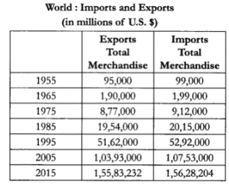
(9.1) Which aspect of trade has shown rapid growth?
(9.2) Has the total volume of trade increased or decreased?
(9.3) Why does import take place? Write any two reasons.
Answer: (9.1) Import aspect has shown major growth.
(9.2) The total volume of trade has increased over the years.
(9.3) Imports are important for the development and growth of national economics because not all countries have the resources and skills required to produce certain goods and services.
Question 10. “The period from 1901 to 1921 is referred to as a stagnant phase of India’s population growth.” Substantiate the statement. [3]
Answer: The period from 1901-1921 is referred to as a period of stagnant growth of India’s population, since in this period, the growth rate was very low, even recording a negative growth rate during 1911-1921. Both the birth rate and death rate were high keeping the rate of increase in population low.
Poor health and medical services, illiteracy of people at large, and inefficient distribution system of food and other basic necessities were largely responsible for high birth and death rates in this period.
Question 11. How does intermixing of people from diverse cultures due to migration have positive values? Explain. [3]
Answer: Migration leads to intermixing of people from diverse cultures. It has positive contributions such as the evolution of composite culture and breaking through the narrow considerations and widens up the mental horizon of the people at large. It helps to promote national integration, loosens die rigidity in terms of social barriers like caste and religion. Intermixing of people helps in decreasing the social gaps formed between different castes and classes.
Question 12. Describe the development of medieval towns in India during the Mughal period. [3]
OR
Describe the development of modern towns in India during the British period.
Answer: The Mughal period observed the development of many cities and towns. About 100 of the existing towns have their roots in the medieval period. These were well connected with roadways and majorly developed as capitals or headquarters of principalities and kingdoms. There are fort towns. Agra was then the capital and was well connected ‘ with the rest of the country. The other important towns included Delhi, Hyderabad, Jaipur, Lucknow, and Nagpur. These towns grew bigger and occupied great significance in terms of administration, trade, and manufacturing.
OR
The British and other Europeans developed a number of towns in India. They first developed some trading ports such as Mumbai, Chennai, Kolkata, Surat, Daman, Goa, Pondicherry, etc. for the ease of trade and commerce. Gradually they established their administrative centers, hill towns as summer resorts, etc. Towns based on modern industries also evolved after 1850. For eg., a large number of towns were developed as administrative headquarters, eg., Chandigarh, Bhubaneswar, Gandhinagar, Dispur, etc. and as industrial centers such as Durgapur, Bhilai, Sindri, Barauni, etc. Some old towns also developed as satellite towns around metropolitan cities such as Ghaziabad, Rohtak, Gurgaon around Delhi. With increasing investment in rural areas, a large number of medium and small towns have developed all over the country.
Question 13. Study the given map carefully and answer the questions that follow:
(13.1) Mention the source of origin of this canal.
(13.2) Why is the area to the east of the canal under lift irrigation?
(13.3) Explain the economic significance of this canal for the command area. [4]
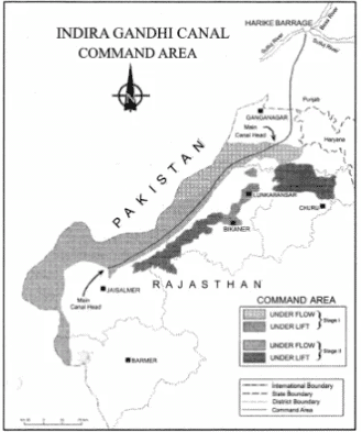
Answer:
(13.1) Canal originates at Harike Barrage/Confluence of Satluj and Beas.
(13.2) Areas of the East of canal under lift irrigation because water is lifted up to make it flow against the slope of the land/high land area.
(13.3) Canal irrigation has led to increasing in cultivated area and intensity of cropping. Traditional crops sown here like Gram and Bajra have been replaced by Wheat, Cotton, Groundnut, and Rice. It led to an increase in agriculture and productive livestock.
Question 14. Explain the economic and cultural factors that influence the distribution of population in the world. [3 + 2 = 5]
Answer: Economic Factors :
1. Minerals: Areas rich in mineral deposits result in better employment opportunities and hence have higher population concentration. Industrial towns are found to develop near mining centers. They favour high density of population. For eg., Durgapur and Jamshedpur.
2. Urbanisation: Urban settlements offer a better standard of living, medical facilities, well-developed transport networks, and better employment opportunities, etc. These facilities encourage rural to urban migration resulting in a high density of population in the megacities of the world.
3. Industrialisation: Industrial belts offer a scope of various types of employment opportunities and attract large-scale migration. This includes factory workers, bank employers, shopkeepers, etc. Cultural Factors: Places having religious and cultural significance attract more people e.g., Varanasi, Ayodhya, Mathura. In some countries, favorable government policies and incentives peaceful atmosphere and other facilities resulting in high population densities.
Question 15. Explain with examples how commercial livestock rearing has become a specialized activity in the world. [1 × 5 = 5]
Answer: It is a modern highly commercial activity where livestock is reared on permanent ranches. Commercial livestock rearing is more organized and capital intensive. This is a specialized activity in which only one type of animal is reared. Grasslands of USA, Australia, New Zealand. The following characteristics also make it a highly specialized activity.,
- Special care is taken about the fodder, types of machinery, health of the livestock. This makes it highly capital intensive.
- Modern healthcare is provided to the livestock.
- It is a highly mechanized activity and used modern technology.
- The number of animals is kept according to the carrying capacity of the ranches.
- The rearing of animals is done on a scientific basis.
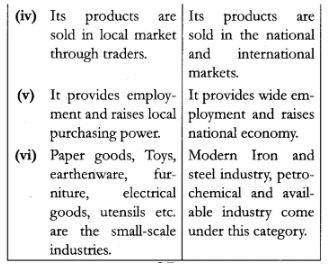
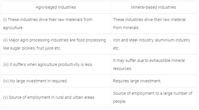
Question 16. Differentiate between ‘small scale manufacturing’ and ‘large scale manufacturing’ in the world.
OR
Differentiate between agro-based industries and mineral-based industries in the world. [5]
Answer: Small-scale manufacturing and large-scale manufacturing in the world :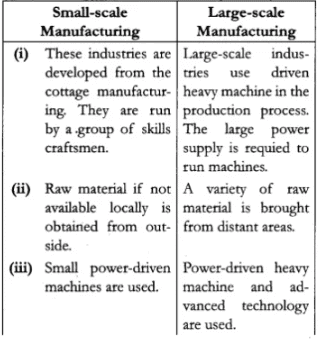
OR
Agro-based industries and Mineral-based industries in the world:
Question 17. Describe the significance of ‘Trans-Siberian Railway’. ‘ [1 × 5 = 5] OR Describe the significance of ‘Trans-Canadian Railway’.
Answer: The significance of ‘Train-Siberian Railways’:
- Trans-Siberian Railway’s major rail route of Russia runs from St. Petersburg in the west to Vladivostok on the Pacific Coast in the east.
- It is the most important route in Asia and the longest (9,332 km) double-tracked and electrified transcontinental railway in the world.
- It has helped in opening up its Asian region to West European markets. It runs across the Ural Mountains, Ob, and Yenisei rivers; Chita is an important agro centre and Irkutsk is a fur center.
- It connects European Russia with Asiatic Russia.
OR
Trans-Canadian railway line is considered as the economic artery of Canada for the following reasons :
- Trans-Canadian railway line is about 7050 km long rail-line in Canada, runs from Halifax in the east to Vancouver on the Pacific coast passing through Montreal, Ottawa, Winnipeg, and Calgary.
- It was constructed in 1886, as part of an agreement to make British Columbia on the west coast join the Federation of States.
- It gained economic significance because it connected the Quebec-Montreal industrial Region with the wheat belt of Prairie region and the coniferous forest region in the north.
- Each of these regions became complementary to the other.
- A loop line from Winnipeg to Thunder bay connects this rail line with One of the important waterways of the world.
- This line is the economic artery of Canada, wheat and meat are the important exports on this route.
Question 18. Explain with examples how ‘modern agricultural technology has brought a significant increase in agricultural output in India. [1 × 5 = 5]
Answer: Modern agricultural technology has brought a significant increase in the agricultural output in India the following way :
- Production and field of many crops like rice and wheat have increased.
- The availability and use of chemical fertilizers and pesticides have enhanced the productivity of the farms.
- The extension of irrigation facilities even in the removed dry areas has helped to increase productivity.
- The use of HYV seeds helped to increase the productivity of crops like wheat, rice, cotton jute etc.
- India ranked first in the production of pulses and jute.
Question 19. “The non-conventional sources of energy in India Will provide more sustained and environment-friendly energy.” Examine the statement. [5]
OR
“Conversion of mineral resources is essential for the development of India.” Examine the statement.
Answer: Nonconventional energy sources are the only sustainable sources. They are renewable resources like Solar, Wind, Hydro-Geothermal, and Biomass. These energy resources are more equitably distributed. These are environmentally friendly and cost-effective in the long run. India has huge prospects in the production of such resources that will provide sustained and environmentally friendly energy in the future :
- The large expanse of deserts and the coastlines are an ideal site for the generation of wind energy. The largest wind farm cluster in India is located in Tamilnadu.
- Biogas is an important nonconventional energy resource in rural areas. Shrubs, animal, and agricultural wastes are used to produce biogas. The use of biogas for domestic consumption in rural areas can reduce the burning of fuelwood and thus reduce the felling of trees.
- The long coastline of India is an ideal site for the generation of tidal energy. It can be used for the generation of electricity which is non-polluting and a sustainable source of energy.
OR
Conservation of mineral resources is essential for the development of India.
- They are unevenly distributed over space. There is an inverse relationship in quantity and quality of minerals.
- All minerals are exhaustible over time. These take a long to develop geologically. They cannot be replenished immediately at the time of need.
- Minerals are an integral part of our life. They are used for various purposes. They are used in the manufacturing of a tiny pin to large constructions e.g., automobiles, roads, railway tracks, etc. Hence conservation is necessary for continuous use. The presence of resources and minerals contributes a lot to the economic growth of the country. It also creates a lot of revenue for the government to put to better use. It makes transportation faster.
Question 20. “Indian railways network is one of the longest networks of the world and has contributed a lot to the growth of the economy.” Support the statement. [3 + 2 = 5]
Answer: The Indian railway network is spread over 63,221 km making it one of the longest railway networks in the world. It plays a great role in the economic development of the country in the following way :
- It has connected the remote rural areas to the urban markets. This helps the farmers to carry their agricultural products to the urban centers.
- Railways help to carry bulky raw materials like coal from the mining centers to the industrial units.
- It has helped to connect the rural areas to the urban centers. This has helped to generate employment opportunities for rural people. People can easily move from place to place in search of employment or for business purposes.
- The railways are often a point of connection to the important ports of India. Thus, the export items are often transported to the ports through the railways.
- It also creates a lot of revenue for the government to put to better use. It makes transportation faster.
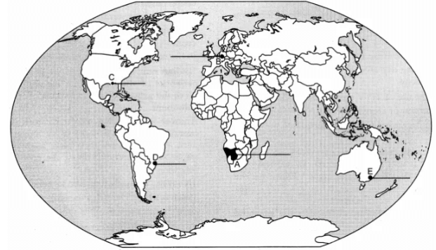
Question 21. On the given political outline map of the World, five geographical features have been marked as A, B, C, D, and E. Identify them with the help of the following information and write their correct names on the lines drawn near them :
(A) An area of nomadic herding
(B) An industrial region
(C) An international airport
(D) A megacity
(E) The terminal station of ‘Trans-Continental Railway’. [1 × 5 = 5]
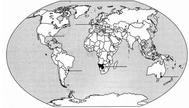
Answer:
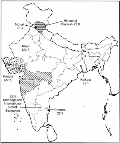
Question 22. Locate and label any five of the following geographical features on the political outline map of India : [5 × 1 = 5]
(22.1) The city with more than 10 million population in West Bengal. .
(22.2) The leading producer State of cotton.
(22.3) The software technology park in Punjab.
(22.4) The Headquarters of Southern Railway Zone.
(22.5) The international airport of Karnataka.
(22.6) The major seaport in Gujarat.
(22.7) Khetri copper mines.
(22.8) The State with the lowest level of urbanization.
Answer:
|
168 docs|32 tests
|
FAQs on Class 12 Geography Solved Paper (2019 Out Delhi Set-I) - Geography for Grade 12
| 1. What are the main topics covered in the Class 12 Geography Solved Paper (2019 Out Delhi Set-I) Humanities/Arts? |  |
| 2. How can I prepare effectively for the Class 12 Geography exam? | |
| 3. Are there any important geographical terms that I should focus on for the Class 12 Geography exam? | |
| 4. What are the benefits of solving previous years' question papers for the Class 12 Geography exam? | |
| 5. How can I effectively revise the regional geography portion for the Class 12 Geography exam? | |


Viva Questions
,Class 12 Geography Solved Paper (2019 Out Delhi Set-I) | Geography for Grade 12
,Previous Year Questions with Solutions
,Free
,practice quizzes
,Class 12 Geography Solved Paper (2019 Out Delhi Set-I) | Geography for Grade 12
,Summary
,mock tests for examination
,shortcuts and tricks
,Class 12 Geography Solved Paper (2019 Out Delhi Set-I) | Geography for Grade 12
,study material
,Sample Paper
,Semester Notes
,ppt
,Important questions
,past year papers
,Extra Questions
,Exam
,video lectures
,MCQs
,Objective type Questions
;


Class 12 Geography Solved Paper (2019 Out Delhi Set-I) Free PDF Download
Importance of Class 12 Geography Solved Paper (2019 Out Delhi Set-I)
Class 12 Geography Solved Paper (2019 Out Delhi Set-I) Notes
Class 12 Geography Solved Paper (2019 Out Delhi Set-I) Grade 12 Questions
Study Class 12 Geography Solved Paper (2019 Out Delhi Set-I) on the App
|
© EduRev
|
Education Revolution
|


|


