Class 9 Geography Chapter 3 Notes - Drainage
| Table of contents |
|
| Introduction |
|
| Drainage System in India |
|
| The Himalayan Rivers |
|
| The Peninsular Drainage System |
|
| Lakes |
|
| Role of Rivers in Economy |
|
| River Pollution |
|
| Difficult Words |
|
Introduction
The term drainage refers to the system of rivers in a given area. When you look at a physical map, you can see how small streams from various directions merge to form the main river, which eventually flows into a larger body of water like a lake, sea, or ocean. The region serviced by a single river system is called a drainage basin. If you examine a map closely, you will find that any elevated region, such as a mountain or hill, separates two drainage basins. This elevated area is known as a water divide.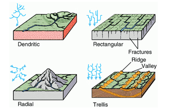 Types of Drainage Patterns
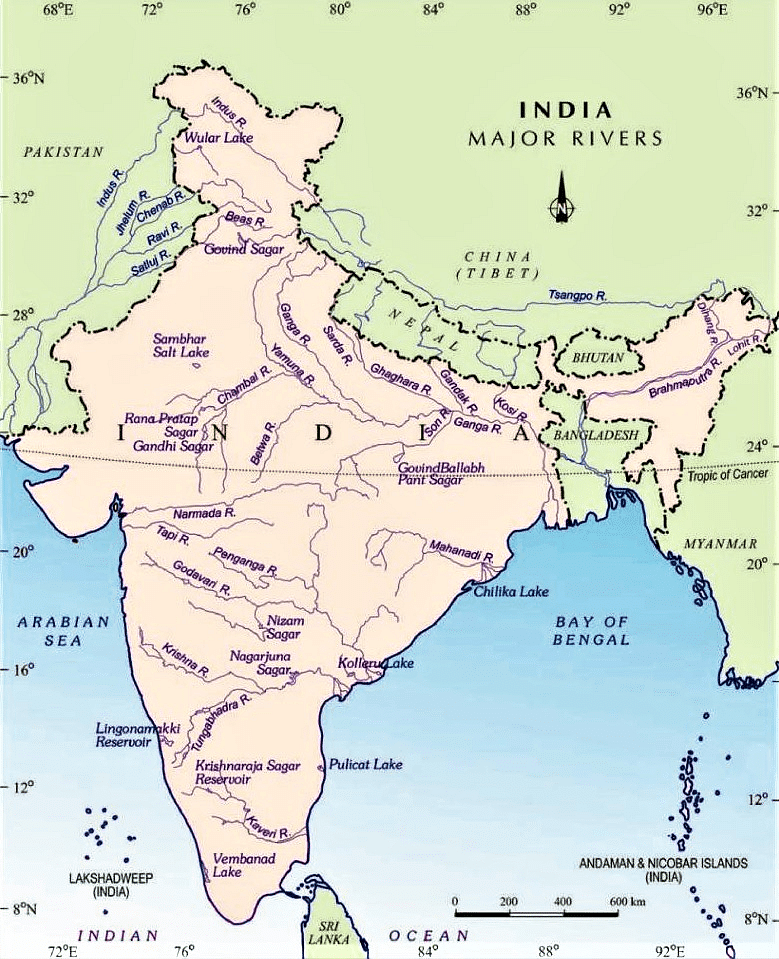
Drainage System in India
The drainage systems of India are mainly shaped by the large landforms of the subcontinent. The Indian rivers can be divided into two main categories:
- The Himalayan Rivers
- The Peninsular Rivers
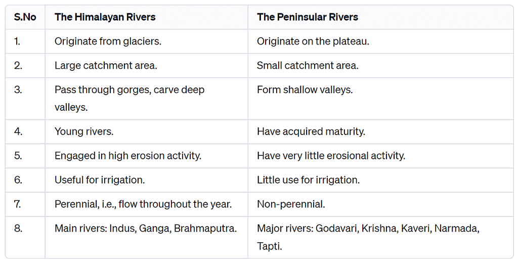
The Himalayan Rivers
The major Himalayan Rivers include the Indus, Ganga, and Brahmaputra. These rivers are lengthy and have many significant tributaries.
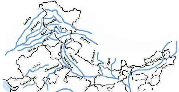
1. The Indus River System
- The Indus rises in Tibet, near Lake Mansarovar, and forms a beautiful gorge in the Ladakh region.
- Flowing west, it enters India in the Ladakh district of Jammu and Kashmir, where it is joined by tributaries like the Zaskar, Nubra, Shyok, and Hunza.
- The Indus flows through Baltistan and Gilgit before emerging from the mountains at Attock.
- The Satluj, Beas, Ravi, Chenab, and Jhelum join the Indus near Mithankot in Pakistan.
2. The Ganga System
- The source of the Ganga, called the ‘Bhagirathi,’ is fed by the Gangotri Glacier and meets the Alaknanda at Devprayag in Uttarakhand. At Haridwar, the Ganga flows from the mountains to the plains.
- The Ganga is joined by several tributaries from the Himalayas, including the Yamuna, Ghaghara, Gandak, and Kosi. The Yamuna rises from the Yamunotri Glacier in the Himalayas and joins the Ganga at Allahabad. The Ghaghara, Gandak, and Kosi also originate in the Nepal Himalaya.
- Main tributaries from the peninsular uplands include the Chambal, Betwa, and Son.
- The Ganga flows east to Farakka in West Bengal, the northernmost point of the Ganga delta. Here, it splits; the Bhagirathi-Hooghly flows south through the deltaic plains to the Bay of Bengal. The main river continues south into Bangladesh, where it meets the Brahmaputra. Further downstream, it is called the Meghna and ultimately flows into the Bay of Bengal. The delta formed by these rivers is known as the Sunderban Delta, which is vital for its biodiversity and ecological significance.
 Ganga River System and Brahmaputra River System

3. The Brahmaputra System
- The Brahmaputra rises in Tibet, east of Mansarovar Lake. It is slightly longer than the Indus and flows east alongside the Himalayas.
- Upon reaching Namcha Barwa (7757 m), it makes a ‘U’ turn and enters India in Arunachal Pradesh through a gorge, where it is known as the Dihang. It is joined by the Dibang, Lohit, and many other tributaries, forming the Brahmaputra in Assam.
- In India, it flows through a high rainfall area, carrying a large volume of water and significant amounts of silt. The Brahmaputra has a braided channel throughout Assam, creating many river islands, with Majuli being the largest inhabited river island in the world.
- During the monsoon season, the river can overflow its banks, causing extensive flooding in Assam and Bangladesh. The riverbed accumulates large amounts of silt, which can raise the riverbed and shift its channel frequently.
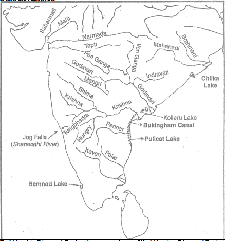
The Peninsular Drainage System
The Peninsular drainage system is older than the Himalayan drainage system. This is shown by the wide, mostly flat valleys and the well-developed rivers. Peninsular rivers have a fixed path, do not meander, have small drainage areas, and flow non-continuously. The main water divide in Peninsular India is formed by the Western Ghats, which stretch from north to south near the western coast. Most major rivers in this region, such as the Mahanadi, Godavari, Krishna, and Kaveri, flow eastwards into the Bay of Bengal and form deltas at their mouths. Additionally, there are many small streams flowing west of the Western Ghats. The Narmada and Tapi are the only long rivers that flow westward and create estuaries. The drainage basins of these rivers are generally smaller compared to those of the Himalayan rivers.
1. The Narmada Basin
The Narmada begins in the Amarkantak hills of Madhya Pradesh at a height of about 1,057 m. It flows westwards through a rift valley formed by faulting and empties into the Arabian Sea south of Bharuch. The Sardar Sarovar Project has been built on this river. Along its route to the sea, the Narmada creates many scenic spots, including:
- Marble Rocks near Jabalpur, where the river flows through a deep gorge.
- Dhuadhar Falls, where the river cascades over steep rocks.
All tributaries of the Narmada are quite short and join the main river at right angles. The Narmada basin includes parts of Madhya Pradesh and Gujarat.
2. The Tapi Basin
The Tapi originates in the Satpura ranges in the Betul district of Madhya Pradesh. About 79 percent of its basin is in Maharashtra, 15 percent in Madhya Pradesh, and 6 percent in Gujarat. The Tapi flows in a rift valley parallel to the Narmada but is shorter.
3. The Godavari Basin
The Godavari is the largest river system in the peninsula, rising from the slopes of the Western Ghats in the Nashik district of Maharashtra. It is around 1,500 km long, and due to its size, it is often called the Dakshin Ganga. The Godavari's drainage basin is the largest among the peninsular rivers, covering parts of:
- Maharashtra (about 50 percent of the basin area)
- Madhya Pradesh
- Odisha
- Andhra Pradesh
The Godavari is joined by several tributaries, including the Purna, Wardha, Pranhita, Manjra, Wainganga, and Penganga. It ultimately drains into the Bay of Bengal.
4. The Mahanadi Basin
The Mahanadi rises in the highlands of Chhattisgarh near Sihawa and flows through Odisha to reach the Bay of Bengal. Fifty-three percent of its drainage basin is in Madhya Pradesh and Chhattisgarh, while 47 percent is in Odisha. Its length is approximately 860 km.
5. The Krishna Basin
The Krishna is the second-largest east-flowing river in the peninsula, rising near Mahabaleshwar in the Sahyadri range. It flows for about 1,400 km and has several tributaries, including the Tungabhadra, Koyana, Ghatprabha, Musi, and Bhima.
6. The Kaveri Basin
The Kaveri originates in the Brahmagri range of the Western Ghats in the Kogadu district of Karnataka at an elevation of 3,341 m. The upper catchment area receives rainfall during the southwest monsoon (summer), while the lower part gets rainfall in the northeast monsoon (winter). This allows the river to flow throughout the year with less fluctuation compared to other peninsular rivers. Its important tributaries include the Kabini, Bhavani, and Amravati.

Lakes
- Sambhar Lake is the largest inland salt lake in India, located in Rajasthan. Other salt lakes in Rajasthan include Didwana, Degana, Pachadra, Kuchaman, and Lunkaransar.
- Lunar Lake, found in Maharashtra, is a crater lake.
- Chilka Lake, in the Puri district of Odisha and south of the Mahanadi delta, is the biggest lake in the country.Loktak Lake
- Kolleru Lake is a deltaic lake in Andhra Pradesh, between the Krishna and Godavari deltas.
- Loktak Lake in Manipur is the largest freshwater lake in Northeast India.
- Vembanad Lake is a lagoon in Kerala and a key tourist destination, featuring coconut islands.
- Gohna Lake, located near Devprayag in Garhwal, was formed by a large landslide blocking a tributary of the Ganga.
- Wular Lake and Dal Lake are tectonic lakes created by faulting activities.

Importance of Lakes
- Lakes are essential for regulating rivers, preventing floods during heavy rainfall, and maintaining a steady water flow in dry periods.
- They provide sources of hydropower and freshwater, and help moderate the climate.
- Lakes support diverse ecosystems, enhance natural beauty, and offer recreational activities, making them vital and multifunctional parts of the environment.
Role of Rivers in Economy
- Rivers have been crucial throughout human history. Water from rivers is a basic natural resource necessary for various human activities.
- Using rivers for irrigation, navigation, and hydro-power generation is especially important, particularly in a country like India, where agriculture is the main source of income for most of the population.
- Riverbanks have drawn settlers since ancient times, and these places have developed into large cities.
- Industrial growth has thrived along rivers. Many industrial processes rely on water as a raw material, as a coolant, and for producing hydroelectricity.
- The increasing demand for water from rivers for domestic, municipal, industrial, and agricultural uses naturally impacts water quality. A significant amount of untreated sewage and industrial waste is dumped into rivers, harming both water quality and the river's ability to clean itself.
- Worries about rising pollution in our rivers have led to the start of various action plans aimed at cleaning them, such as the Ganga Action Plan (GAP) initiated in 1985 and the National River Conservation Plan (NRCP) expanded in 1995. The aim of the NRCP is to improve the water quality of rivers, which are major water sources in the country, through pollution control measures.
River Pollution
- The increasing demand for water from rivers due to domestic, municipal, industrial, and agricultural needs is impacting water quality.
- This demand leads to more water being taken from rivers, which decreases their flow.
- At the same time, untreated sewage and industrial waste are being discharged into these rivers.
- This not only deteriorates water quality but also reduces the river's ability to cleanse itself.
- For instance, when there is enough water flow, the Ganga can dilute and manage pollution within 20 km of large cities.
- However, growing urban and industrial activities obstruct this natural process, resulting in higher pollution levels in many rivers.
- The rising pollution levels have prompted the initiation of various action plans aimed at cleaning the rivers.
National River Conservation Plan (NRCP)
- The river cleaning efforts in the country began with the launch of the Ganga Action Plan (GAP) in 1985.
- This plan was later expanded to include other rivers under the National River Conservation Plan (NRCP) in 1995.
- The aim of the NRCP is to enhance the water quality of rivers that are vital water sources across the country by implementing pollution control measures.
- After a review by the steering committee of the National River Conservation Authority, improvements based on previous experiences were made to the NRCP.
- Currently, pollution control projects are active in 57 towns, with 215 initiatives approved.
- So far, 69 of these initiatives have been completed, with the goal of intercepting, diverting, and treating one million litres of sewage.
For a detailed understanding of this chapter, check the video below.
Some Interesting Knowledge
- The world’s largest drainage basin is the River Amazon which is situated in South America.
- According to the regulation of the Indus Water Treaty (1960), India can use only 20 per cent of the total water carried by the Indus River system. This water is used for irrigation in the Punjab, Haryana, and the southern and western parts of Rajasthan.
- The Sundarban Delta derived its name from the Sundari tree which grows well in marshland. it is the world’s largest and fastest-growing delta. it is also the home of the Royal Bengal Tiger.
- The Brahmaputra is known as the Tsang Po in Tibet and Jamuna in Bangladesh.
- The river Kaveri is the second biggest waterfall in India. it is known as Sivasmudram. the fall supplies hydroelectric power to Mysore, Bangalore, and the Kolar Gold Field.
- 71 percent of the world’s surface is covered with water, but 97 percent of that is saltwater. Of the 3 percent that is available as freshwater, three-quarters of it is trapped as ice.
- Lakes of large extent are called the seas, like the Caspian, the Dead, and the Arab seas.
Difficult Words
- Drainage Basin: The area drained by a single river system where precipitation collects and drains off into a common outlet, such as into a river, bay, or other body of water.
- Tributary: A river or stream flowing into a larger river or lake.
- Water Divide: An elevated area, such as a mountain or upland, that separates two drainage basins.
- Rift Valley: A large elongated depression with steep walls formed by the downward displacement of a block of the earth's surface between nearly parallel faults or fault systems.
- Braided Channel: A network of river channels separated by small, often temporary, islands called braid bars. These typically form in rivers with high sediment loads and strong currents.
- Riverine Island: An island formed by the course of a river. Majuli in the Brahmaputra River is an example of such an island.
- Alluvial Soil: Soil deposited by rivers. It is typically fertile and good for agriculture.
- Peninsular Plateau: A plateau in India making up the majority of the southern part of the country. It is bordered by two mountain ranges, the Eastern and Western Ghats.
- Sundarban Delta: The large delta formed at the mouth of the Ganges and Brahmaputra River systems. It is noted for its wide mangrove forests and is home to the Royal Bengal Tiger.
- Indus Water Treaty: A water-distribution treaty between India and Pakistan, brokered by the World Bank, to use the water available in the Indus River and its tributaries.
|
53 videos|437 docs|80 tests
|
FAQs on Class 9 Geography Chapter 3 Notes - Drainage
| 1. What are the main characteristics of the Himalayan rivers in India? |  |
| 2. How do the peninsular rivers differ from the Himalayan rivers? | |
| 3. What role do rivers play in the economy of India? | |
| 4. What are the main causes of river pollution in India? | |
| 5. How can the pollution of rivers be controlled or reduced in India? | |

|
39.1K Views |

|
4.63/5 Rating |

|
Nov 30, 2024 Last updated |

|
Explore Courses for Class 9 exam
|
|
ppt
,Important questions
,Class 9 Geography Chapter 3 Notes - Drainage
,Previous Year Questions with Solutions
,Class 9 Geography Chapter 3 Notes - Drainage
,Objective type Questions
,past year papers
,Viva Questions
,study material
,shortcuts and tricks
,Exam
,Extra Questions
,Sample Paper
,Summary
,mock tests for examination
,Class 9 Geography Chapter 3 Notes - Drainage
,video lectures
,MCQs
,Semester Notes
,Free
,practice quizzes
;


Detailed Chapter Notes - Drainage Free PDF Download
Importance of Detailed Chapter Notes - Drainage
Detailed Chapter Notes - Drainage
Detailed Chapter Notes - Drainage Class 9 Questions
Study Detailed Chapter Notes - Drainage on the App
|
© EduRev
|
Education Revolution
|


Follow Us
|