Geography: CBSE Sample Question Paper - 3 | Geography for Grade 11 PDF Download
Read the below instructions very carefully and follow them strictly.
(i) Question paper is divided into 3 Sections – A, B and C.
(ii) In Section A, question numbers 1 to 15 are Objective type Multiple choice questions carrying 1 mark each. Attempt any 14 questions. Write the correct answer only in your answer sheets.
(iii) In Section B, Question numbers 16 and 17 are Short Source Based and Graph Based questions respectively carrying 3 marks each. Answer any three questions out of 4. Each of these sub questions carry 1 mark.
(iv) In Section C, Question numbers 18 to 22 are short answer questions carrying 3 marks each. Answers to these questions should not exceed 60-80 words.
(v) In Section C, Question numbers 23 to 27 are long answer questions carrying 5 marks each. Answers to these questions should not exceed 120-150 words.
(vi) Question numbers 28 and 29 are related to location and labeling and Identification of geographical features on maps respectively, carrying 5 marks each.
(vii) Outline map of India and World provided to you must be attached with your answer book.
(viii) Use of template or stencils for drawing outline maps is allowed.
Q.1. The consequence of erosion is:
(a) rockslide
(b) sliding
(c) deposition
(d) landslide
Ans: (c)
Q.2. The uppermost layer of the atmosphere above the ionosphere is known as the:
(a) Exosphere
(b) tropopause
(c) mesopause
(d) ionosphere
Ans: (a)
Q.3. Mixed tides usually occur along the:
(a) east coast of South America
(b) west coast of South America
(c) east coast of North America
(d) west coast of North America
Ans: (d)
Q.4. The atmosphere is indirectly heated by the earth’s:
(a) radiation
(b) insulation
(c) convection
(d) advection
Ans: (a)
Q.5. Organisms of an ecosystem are linked together through:
(a) food chain
(b) ecology
(c) biosphere
(d) habitat
Ans: (a)
Q.6. The Chenab is the largest tributary of the:
(a) Beas
(b) Brahmaputra
(c) Indus
(d) Jhelum
Ans: (c)
Q.7. Arrange the correct sequence of column II against the column I
(a) III – 1, IV – 2, I – 3, II – 4
(b) I – 4, II – 3, III – 2, IV – 1
(c) IV – 3, I – 4, II – 1, III – 2
(d) II – 2, III – 1, IV – 4, I – 3
Ans: (b)
Q.8. Pangaea began to split around:
(a) 100 million years ago
(b) 200 million years ago
(c) 300 million years ago
(d) 400 million years ago
Ans: (b)
Q.9. Fill in the blanks : ____________comprises country/rural and town/urban planning.
Ans: Regional planning
Q.10. The location where sinking of a plate occurs is called a:
(a) Subduction Zone
(b) Reduction Zone
(c) Induction Zone
(d) Deduction Zone
Ans: (a)
Q.11. The temperature distribution is generally shown on the map with the help of:
(a) heat budget
(b) isotherms
(c) mesotherms
(d) radiotherms
Ans: (b)
Q.12. India has an area of:
(a) 1.28 million sq km
(b) 3.28 million sq km
(c) 4.28 million sq km
(d) 5.28 million sq km
Ans: (b)
Q.13. A river drains the water collected from a specific area, which is called its:
(a) catchment area
(b) attachment area
(c) drainage area
(d) watershed area
Ans: (a)
Q.14. The gas that is transparent to the incoming solar radiation but opaque to the outgoing terrestrial radiation is known as :
(a) Carbon dioxide
(b) oxygen
(c) nitrogen
(d) helium
Ans: (a)
Q.15. Which one of the following gases is transparent to incoming solar radiation and opaque to outgoing terrestrial radiation :
(a) Oxygen
(b) Nitrogen
(c) Helium
(d) Carbon dioxide
Ans: (d)
Q.16. Read the Case Study given below and answer the questions that follow:
Crust is the outermost solid part of the earth. It is brittle in nature. The thickness of the crust varies under the oceanic and continental areas. Oceanic crust is thinner as compared to the continental crust. The mean thickness of oceanic crust is 5 km whereas that of the continental is around 30 km. The continental crust is thicker in the areas of major mountain systems. It is as much as 70 km thick in the Himalayan region.
The portion of the interior beyond the crust is called the mantle. The mantle extends from Moho’s discontinuity to a depth of 2,900 km. The upper portion of the mantle is called the no sphere. The word astheno means weak. It is considered to be extending upto 400 km. It is the main source of magma that finds its way to the surface during volcanic eruptions. The crust and the uppermost part of the mantle are called lithosphere. Its thickness ranges from 10-200 km. The lower mantle extends beyond the asthenosphere. It is in solid state.
As indicated earlier, the earthquake wave velocities helped in understanding the existence of the core of the earth. The core mantle boundary is located at the depth of 2,900 km. The outer core is in liquid state while the inner core is in solid state. The core is made up of very heavy material mostly constituted by nickel and iron. It is sometimes referred to as the nife layer.
Answer any three questions:
(a) Which of the following layers of earth is brittle in nature?
(i) Crust
(ii) Mantle
(iii) Core
(iv) All of the above
Ans: (i)
(b) Which of the following layers is referred to as Nife layer ?
(i) Crust
(ii) Mantle
(iii) Core
(iv) All of the above
Ans: (iii)
(c) What is the correct sequence of the layers of the earth from innermost to outermost ?
(i) Crust – mantle – core
(ii) Core – mantle – crust
(iii) Crust – core – mantle
(iv) Mantle – core – crust
Ans: (ii)
(d) The core mantle boundary is located at the depth of:
(i) 2,300 km
(ii) 2,700 km
(iii) 2,600 km
(iv) 2,900 km
Ans: (iv)
Q.17. Study the given graph carefully and answer the following questions: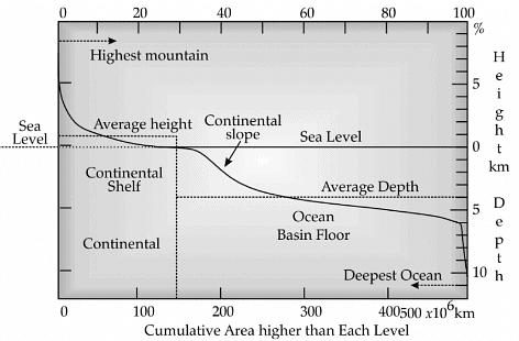
Answer any three questions:
(a) According to the graph which of the following is in the correct sequence in terms of increasing height?
(i) Continental Slope – Continental Shelf – Ocean Basin Floor
(ii) Continental Shelf – Continental Slope –Ocean Basin Floor
(iii) Continental Shelf– Ocean Basin Floor– Continental Slope
(iv) Ocean Basin Floor – Continental Slope – Continental Shelf
Ans: (iv)
(b) According to the graph what is the average depth of the ocean?
(i) 11 km below the sea level
(ii) 8 km below the sea level
(iii) 4 km below the sea level
(iv) 7 km below the sea level
Ans: (iii)
(c) According to the graph what is the average height of the continent?
(i) 8 km above the sea level
(ii) 1 km above the sea level
(iii) 4 km above the sea level
(iv) 3 km above the sea level
Ans: (ii)
(d) According to the graph the deepest point of the ocean is lies at:
(i) 11 km below the sea level
(ii) 8 km below the sea level
(iii) 4 km below the sea level
(iv) 7 km below the sea level
Ans: (i)
Q.18. Geography is an integration of social sciences and physical sciences. Explain?
Ans:
(i) Geography is an integration of social sciences and physical sciences as the basic aim of both is to understand the reality of nature. All the social science disciplines, viz, sociology, political science, demography study different aspects of social reality. The branches of geography viz, social , political, economic and population and settlements are closely linked with these disciplines as each of them has spatial attributes.
(ii) The core concern of political science is territory, people and sovereignty while political geography is also interested in the study of the state as a spatial unit as well as people and their political behaviour.
(iii) History helps in knowing man-made activities over the period of time ,whereas Physics helps in calculating the effect of climate on man. The change in the climate further has an influence on the occupation of the people.
(iv) Economics deals with the basic attributes of the economy such as production, distribution, exchange and consumption. Each of these attributes also has spatial aspects and here comes the role of economic geography.
(v) Mathematics and arts also have contributed to the development of geography to measure area and dimensions of the earth. Hence, it can be rightly said that all the branches of social sciences have a close relationship with the physical sciences.
Q.19. Differentiate between sedimentary rocks and igneous rocks.
How does India’s size make it physically diverse?
Ans: 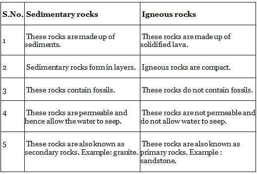
The size of India has endowed her with great physical diversity. Thus, you may appreciate the presence of lofty mountains in the north; large rivers such as Ganga, Brahmaputra, Mahanadi, Krishna, Godavari and Kaveri; green forested hills in the North East and South India; and the vast sandy expanse of Marusthali. You may further appreciate that bounded by the Himalayas in the north, Hindukush and Sulaiman ranges in the northwest, Purvanchal hills in the North-East and by the large expanse of the Indian ocean in the south, it forms a great geographic entity known as the Indian subcontinent. It includes the countries — Pakistan, Nepal, Bhutan, Bangladesh and India.
The Himalayas, together with other ranges, have acted as a formidable physical barrier in the past. Except for a few mountain passes such as the Khyber, the Bolan, the Shipkila, the Nathula, the Bomdila, etc. it was difficult to cross it. It has contributed towards the evolving of a unique regional identity of the Indian subcontinent. The Peninsular part of India extends towards the Indian Ocean. This has provided the country with a coastline of 6,100 km in the mainland and 7,517 km in the entire geographical coast of the mainland plus the island groups Andaman and Nicobar located in the Bay of Bengal and the Lakshadweep in the Arabian Sea. Thus India, as a country, is a physically diverse land providing occurrence of varied resources.
Q.20. What do you know about the oxygen cycle?
Differentiate between convectional rain and orographic rain?
Ans: Oxygen is the main by-product of photosynthesis. It is involved in the oxidation of carbohydrates with the release of energy, carbon dioxide and water. The cycling of oxygen is a highly complex process. Oxygen occurs in a number of chemical forms and combinations. It combines with nitrogen to form nitrates and with many other minerals and elements to form various oxides such as the iron oxide, aluminium oxide and others. Much of oxygen is produced from the decomposition of water molecules by sunlight during photosynthesis and is released in the atmosphere through transpiration and respiration processes of plants.
Q.21. Explain the important features of the Brahmaputra River System?
On the basis of the size of the watershed, the drainage basins of India can be divided into how many groups.
Ans: The Brahmaputra River System:
(i) The Brahmaputra, one of the largest rivers of the world, has its origin in the Chemayungdung Glacier of the Kailash range near the Mansarovar lake. From here, it traverses eastward longitudinally for a distance of nearly 1,200 km in a dry and flat region of southern Tibet, where it is known as the Tsangpo, which means ‘the purifier.’
(ii) The Brahmaputra receives numerous tributaries in its 750 km long journey through the Assam valley.
(iii) The Brahmaputra is well-known for floods, channel shifting and bank erosion. This is due to the fact that most of its tributaries are large, and bring large quantities of sediments owing to heavy rainfall in its catchment area.
On the basis of the size of the watershed, the drainage basins of India are grouped into three categories:
(i) Major river basins with more than 20,000 sq. km of catchment area. It includes 14 drainage basins such as the Ganga, the Brahmaputra, the Krishna, the Tapi, the Narmada, the Mahi, the Pennar, the Sabarmati, the Barak, etc.
(ii) Medium river basins with catchment area between 2,000-20,000 sq. km incorporating 44 river basins such as the Kalindi, the Periyar, the Meghna, etc.
(iii) Minor river basins with catchment areas of less than 2,000 sq. km include a fairly good number of rivers flowing in the area of low rainfall.
Q.22. Discuss any five important minerals along with their characteristics.
Ans: Some of the important minerals and their characteristics are:
(i) Feldspar: Silicon and oxygen are common elements in all types of feldspar and sodium, potassium, calcium, aluminium, etc., are found in specific feldspar varieties. Half of the earth’s crust is composed of feldspar. It has light cream to salmon pink colour. It is used in ceramics and glass making.
(ii) Quartz: It is one of the most important components of sand and granite. It consists of silica. It is a hard mineral virtually insoluble in water. It is white or colourless and used in radio and radar. It is one of the most important components of granite.
(iii) Pyroxene: Pyroxene consists of calcium, aluminium, magnesium, iron and silica. Pyroxene forms 10 percent of the earth’s crust. It is commonly found in meteorites. It is in green or black colour.
(iv) Amphibole: Aluminium, calcium, silica, iron, magnesium are the major elements of amphiboles. They form 7 per cent of the earth’s crust. It is in green or black colour and is used in the asbestos industry. Hornblende is another form of amphiboles.
(v) Mica: It comprises potassium, aluminium, magnesium, iron, silica, etc., It forms 4 per cent of the earth’s crust. It is commonly found in igneous and metamorphic rocks. It is used in electrical instruments.
(vi) Olivine: Magnesium, iron and silica are major elements of olivine. It is used in jewellery. It is usually a greenish crystal, often found in basaltic rocks. Besides these main minerals, other minerals like chlorite, calcite, magnetite, haematite, bauxite and barite are also present in some quantities in the rocks.
Q.23 Geography being a scientific discipline, what do you think how many categories of questions are geography concerned with? Explain.
Ans: Geography as a scientific discipline is concerned with three sets of questions:
(i) Some of the questions are related to the identification of the various patterns of natural and cultural features as found over the surface of the earth. These are the questions about ‘what’?
(ii) The second kind of questions are related to the distribution of the natural and human/cultural features over the surface of the earth. These are the questions about ‘where’?
(iii) The third kind of questions are related to the explanation or the causal relationships between features and the processes and phenomena. This aspect of geography is related to the question ‘why’.
Q.24. Why is geography considered as an important subject?
Explain different types of physical weathering.
Ans: Geography is considered as an important subject because:
(i) As we live on Earth, therefore, it is very important to understand the mechanism of our planet. It gives us a visual sense of the Earth’s surface.
(ii) We are heavily dependent on the natural resources available on the Earth’s surface. In order to know how efficiently it can be used, it is important to study geography.
(iii) Climate is a major deciding factor in the type of crops to be grown, human settlements, food to be eaten, shelter to be built, etc. To understand the interrelationship between the climate and human movements, it is important to study geography as a subject.
(iv) It also helps us connect well and understand the changes that have taken place in the evolution of the Earth. It makes our understanding of the changes that have taken place throughout the geological time better. It also helps us know the land and people in a better sense.
Different types of physical weathering are:
(i) Exfoliation: Exfoliation can occur due to expansion and contraction induced by temperature changes. Exfoliation domes and tors result due to unloading and thermal expansion respectively. Due to differential heating and resulting expansion and contraction of surface layers and their subsequent exfoliation from the surfaces results in smooth rounded surfaces in rocks.
(ii) Frost: Frost is an active agent in cold climatic regions in high altitudes and the cracks are filled with water during the day time, this water is frozen at night when temperature falls below freezing point.
(iii) Pressure: Many igneous and metamorphic rocks crystallise deep in the interior under the combined influence of high pressure and temperature. The salt near surface pores cause splitting of the grains within the rocks which eventually falls off, this results in granules disintegration.
Q.25. How did the Peninsular Drainage System evolve?
Ans: Three major geological events in the distant past have shaped the present drainage systems of Peninsular India:
(i) Subsidence of the western flank of the Peninsula leading to its submergence below the sea during the early tertiary period. Generally, it has disturbed the symmetrical plan of the river on either side of the original watershed.
(ii) Upheaval of the Himalayas when the northern flank of the Peninsular block was subjected to subsidence and the consequent trough faulting. The Narmada and The Tapi flow in through faults and fill the original cracks with their detritus materials. Hence, there is a lack of alluvial and deltaic deposits in these rivers.
(iii) Slight tilting of the Peninsular block from northwest to the southeastern direction gave orientation to the entire drainage system towards the Bay of Bengal during the same period.
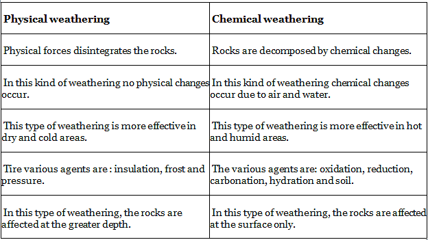
Q.26. Differentiate between physical weathering and chemical weathering.
Ans:
Q.27. Write a note on the biospheres of India.
Ans: A Biosphere Reserve is a unique and representative ecosystem of terrestrial and coastal areas which are internationally recognised within the framework of UNESCO’s Man and Biosphere (MAB) Programme. Ten Biosphere Reserves have been recognised by UNESCO on the World Network of Biosphere Reserves. Some of the important Biosphere reserves are as follows:
(i) The Nilgiri Biosphere Reserve (NBR): The first of the fourteen biosphere reserves of India, was established in September 1986. It embraces the sanctuary complex of Wayanad, Nagarhole, Bandipur and Mudumalai, the entire forested hill slopes of Nilambur, the Upper Nilgiri plateau, Silent Valley and the Siruvani hills. The total area of the biosphere reserve is around 5,520 sq. km. The Nilgiri Biosphere Reserve possesses different habitat types, unspoilt areas of natural vegetation types with several dry scrubs, dry and moist deciduous, semi-evergreen and wet evergreen forests, evergreen sholas, grasslands and swamps. It includes the largest known population of two endangered animal species, namely the NilgiriTahr and the Lion-tailed macaque. The largest south Indian population of elephant, tiger, gaur, sambar and chital as well as a good number of endemic and endangered plants are also found in this reserve. The habitat of a number of tribal groups remarkable for their traditional modes of harmonious use of the environment are also found here.
(ii) The Nanda Devi Biosphere Reserve: It is situated in Uttaranchal includes parts of Chamoli, Almora, Pithoragarh and Bageshwar districts. The major forest types of the reserve are temperate. A few important species are silver weed and orchids like latifolia and rhododendron. The biosphere reserve has a rich fauna, for example the snow leopard, black bear, brown bear, musk deer, snowcock, golden eagle and black eagle. Major threats to the ecosystem are the collection of endangered plants for medicinal use, forest fires and poaching.
(iii) Sunderbans Biosphere Reserve: It is located in the swampy delta of the river Ganga in West Bengal. It extends over a vast area of 9,630 sq. km and consists of mangrove forests, swamps and forested islands. Sunderbans is the home of nearly 200 Royal Bengal tigers. The tangled mass of roots of mangrove trees provide safe homes for a large number of species, from fish to shrimp. More than 170 bird species are known to inhabit these mangrove forests.
(iv) Gulf of Mannar Biosphere Reserve: The Gulf of Mannar Biosphere Reserve covers an area of 105,000 hectares on the southeast coast of India. It is one of the world’s richest regions from a marine biodiversity perspective. The biosphere reserve comprises 21 islands with estuaries, beaches, forests of the nearshore environment, sea grasses, coral reefs, salt marshes and mangroves. Among the Gulf’’s 3,600 plant and animal species are the globally endangered sea cow (Dugong dugon) and six mangrove species, endemic to Peninsular India.
Q.28. In the outline map of the world, mark the following:
(i) AF-Tropical Wet Climate
(ii) EF- Ice Cap Climate
(iii) Cfb-Marine West Coast Climate
(iv) Cwa -Humid Subtropical Climate
(v) Aw-Tropical Wet and Dry Climate
Ans:
(i) SAF-Tropical Wet Climate- Amazon Basin
(ii) EF- Ice Cap Climate- Antarctica
(iii) Cfb-Marine West Coast Climate- Australia
(iv) Cwa -Humid Subtropical Climate- South China
(v) Aw-Tropical Wet and Dry Climate-South of Central Africa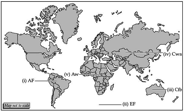
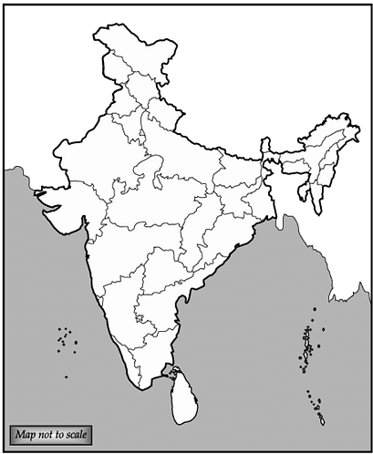
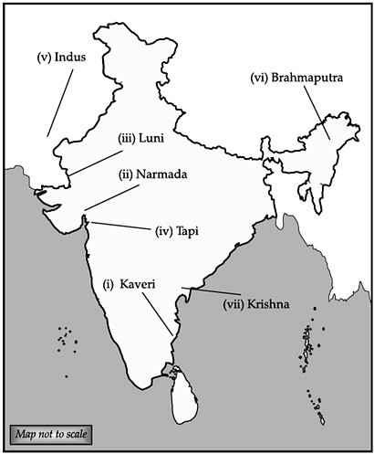
Q.29. Locate and label any five rivers with appropriate symbols on the given political outline map of India:
(i) Kaveri
(ii) Narmada
(iii) Luni
(iv) Tapi
(v) Indus
(vi) Brahmaputra
(vii) Krishna
Ans:
|
75 videos|237 docs|45 tests
|
FAQs on Geography: CBSE Sample Question Paper - 3 - Geography for Grade 11
| 1. What are the major branches of Geography? |  |
| 2. What is the difference between physical geography and human geography? |  |
| 3. How does Geography help in understanding the world around us? |  |
| 4. What is the significance of studying Geography in today's world? |  |
| 5. How does Geography influence different aspects of our daily lives? |  |

|
Explore Courses for Grade 11 exam
|

|


