Geography: CBSE Sample Question Paper - 1 | Geography for Grade 11 PDF Download
General Instructions:
Read the below instructions very carefully and follow them strictly.
(i) Question paper is divided into 3 Sections – A, B and C.
(ii) In Section A, question numbers 1 to 15 are Objective type Multiple choice questions carrying 1 mark each. Attempt any 14 questions. Write the correct answer only in your answer sheets.
(iii) In Section B, Question numbers 16 and 17 are Short Source-Based and Graph-Based questions, respectively carrying 3 marks each. Answer any three questions out of 4. Each of these sub-questions carries 1 mark.
(iv) In Section C, Question numbers 18 to 22 are short answer questions carrying 3 marks each. Answers to these questions should not exceed 60-80 words.
(v) In Section C, Question numbers 23 to 27 are long answer questions carrying 5 marks each. Answers to these questions should not exceed 120-150 words.
(vi) Question numbers 28 and 29 are related to location and labelling and Identification of geographical features on maps respectively, carrying 5 marks each.
(vii) Outline map of India and the World provided to you must be attached with your answer book.
(viii) Use of template or stencils for drawing outline maps is allowed.
Attempt any 14 questions
Q.1. About 85 per cent of the plants and animals that are found nowhere else in the world are found in:
(a) India
(b) Madagascar
(c) Russia
(d) Iceland
Ans: (b)
Q.2. ___________acts like a blanket allowing the earth neither to become too cold nor too hot.
(a) Dust particles
(b) Water vapour
(c) Ozone layer
(d) Carbon dioxide
Ans: (b)
Q.3. The layer that contains the ozone layer is called:
(a) stratosphere
(b) atmosphere
(c) ionosphere
(d) mesosphere
Ans: (a)
Q.4. The earthquakes are measured on:
(a) Victor Scale
(b) Richter Scale
(c) Shadow Scale
(d) Gravity Scale
Ans: (b)
Q.5. Fill in the blanks : ____________ contains calcium, aluminium, magnesium, iron and silica.
Ans: pyroxene
Q.6. The earth’s surface is being continuously subjected to external forces induced basically by:
(a) sunlight
(b) wind
(c) water
(d) power
Ans: (a)
Q.7. The air contains:
(a) water vapour
(b) wind
(c) cloud
(d) mist
Ans: (a)
Q.8. The ocean water is:
(a) dynamic
(b) static
(c) horizontal
(d) vertical
Ans: (a)
Q.9. Interior continental areas receive moderate rainfall varying from:
(a) 90-100 cm per annum
(b) 100 - 200 cm per annum
(c) 200-300 cm per annum
(d) 400-500 cm per annum
Ans: (b)
Q.10. The soil which is formed by the deposition of rivers is known as:
(a) clay soil
(b) alluvial soil
(c) silt
(b) loamy soil
Ans: (b)
Q.11. Arrange the correct sequence of column II against column I
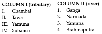
(a) III – 1, IV – 2, I – 3, II – 4
(b) I – 4, II – 3, III – 2, IV – 1
(c) IV – 3, I -4, II – 1, III – 2
(d) II -2, III – 1, IV – 4, I - 3
Ans: (d)
Q.12. Fill in the blanks:
India is located in the _______ part of the continent of Asia.
Ans: south-central
Q.13. Mandovi and Jauri are the important rivers of:
(a) Goa
(b) Varanasi
(c) Madhya Pradesh
(d) Punjab
Ans: (a)
Q.14. How many of the following numbers of Biosphere reserves are recognised by the IUCN:
(a) One
(b) Two
(c) Ten
(d) Four
Ans: (c)
Q.15. Fill in the blanks:
__________ geography studies the spatial pattern of natural vegetation in their habitats.
Ans: Plants
Q.16. Read the Case Study given below and answer the questions that follow:
The distribution of matter and energy was not even in the early universe. These initial density differences gave rise to differences in gravitational forces and it caused the matter to get drawn together. These formed the basis for the development of galaxies. A galaxy contains a large number of stars. Galaxies spread over vast distances that are measured in thousands of light-years. The diameters of individual galaxies range from 80,000-150,000 light-years. A galaxy starts to form by the accumulation of hydrogen gas in the form of a very large cloud called a nebula. Eventually, growing nebula develops localised clumps of gas. These clumps continue to grow into even denser gaseous bodies, giving rise to the formation of stars. The formation of stars is believed to have taken place some 5-6 billion years ago.
A light-year is a measure of distance and not of time. Light travels at a speed of 300,000 km/second. Considering this, the distances the light will travel in one year will be one light year. This equals 9.461×10¹² km. The mean distance between the sun and the earth is 149,598,000 km. In terms of light-years, it is 8.311 minutes.
Our Solar system consists of eight planets. The Nebula from which our Solar system is supposed to have been formed, started its collapse and core formation some time 5-5.6 billion years ago and the planets were formed about 4.6 billion years ago. Our solar system consists of the sun (the star), 8 planets, 63 moons, millions of smaller bodies like asteroids and comets and huge quantities of dust grains and gases. Out of the eight planets, Mercury, Venus, earth and mars are called the inner planets as they lie between the sun and the belt of asteroids the other four planets are called the outer planets.
Alternatively, the first four are called Terrestrial, meaning earth-like as they are made up of rock and metals, and have relatively high densities. The rest four are called Jovian or Gas Giant planets. Jovian means Jupiter-like. Most of them are much larger than the terrestrial planets and have a thick atmosphere, mostly of helium and hydrogen. All the planets were formed sometime about 4.6 billion years ago in the same period. Till recently (August 2006), Pluto was also considered a planet. However, in a meeting of the International Astronomical Union, a decision was taken that Pluto-like other celestial objects (2003 UB313) discovered in the recent past may be called ‘dwarf planet’. Some data regarding our solar system are given in the box below.
Answer any three questions:
(a) A galaxy contains a large number of:
(i) Stars
(ii) Planets
(iii) Moons
(iv) Hydrogen gas
Ans: (i)
(b) A galaxy starts to form by accumulating hydrogen gas in the form of a very large cloud called?
(i) Nebula
(ii) Hydrogen gas
(iii) Dark Matter
(iv) Black Hole
Ans: (i)
(c) Our solar system consists of the sun (the star), _____, millions of smaller bodies like asteroids and comets and huge quantities of dust-grains and gases.
(i) 8 planets, 62 moons
(ii) 8 planets, 63 moons
(iii) 8 planets, 65 moons
(iv) 8 planets, 67 moons
Ans: (ii)
(d) Out of the eight planets, which of the following group of planets are called the Terrestrial planets?
(i) Mercury, Venus, Earth and Saturn
(ii) Mercury, Uranus, earth and mars
(iii) Mercury, Venus, earth and mars
(iv) Mercury, Jupiter, earth and mars
Ans: (iii)
Q.17. Study the given graph carefully and answer the following questions:
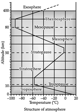 Answer any three questions:
(a) According to the graph the correct sequence as per height (increasing):
(i) Thermosphere – stratopause – mesosphere
(ii) Stratosphere – mesopause – mesosphere
(iii) Mesosphere – mesopause –Thermosphere
(iv) Troposphere – mesopause – stratosphere
Ans: (iii)
(b) According to the graph the range (in KM) of the mesosphere is:
(i) 40 – 50
(ii) 80 – 120
(iii) 50 – 80
(iv) 30 – 90
Ans: (iii)
(c) According to the graphs stratopause is lying between Stratosphere and:
(i) Thermosphere
(ii) Mesosphere
(iii) Troposphere
(iv) Tropopause
Ans: (ii)
(d) According to the graph the temperature range is:
(i) 0 to – 100
(ii) – 5 to – 90
(iii) – 10 to – 70
(iv) – 20 to – 80
Ans: (ii)
Q.18. Name the factors that cause diastrophism?
Ans: All processes that move, elevate or build up portions of the earth’s crust come under diastrophism. They include:
(i) Orogenic processes: It involves mountain building through severe folding and affecting long and narrow belts of the earth’s crust.
(ii) Epeirogenic processes: It involves uplift or warping of large parts of the earth’s crust.
(iii) Earthquakes: It involves local relatively minor movements.
(iv) Plate tectonics: It involves horizontal movements of crustal plates.
Q.19. Write any three points of difference between the systematic approach and regional approach?
Ans: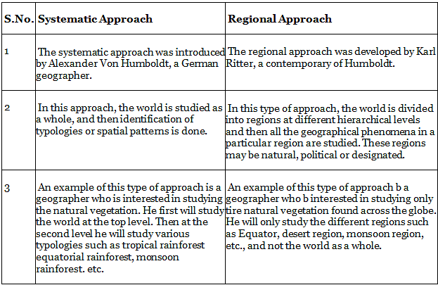
Q.20. Discuss the three major divisions of the ocean floor based on the depth as well as the forms of relief?
Ans: The ocean floor may be segmented into three major divisions based on the depth as well as the forms of relief. These divisions are continental margins, deep-sea basins and mid-ocean ridges.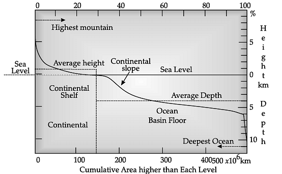
(i) Continental Margins: These form the transition between continental shores and deep-sea basins. They include a continental shelf, continental slope, continental rise and deep-oceanic trenches. Of these, the deep-sea trenches are the areas that are of considerable interest in so far as the distribution of oceans and continents is concerned.
(ii) Abyssal Plains: These are extensive plains that lie between the continental margins and mid-oceanic ridges. The abyssal plains are the areas where the continental sediments that move beyond the margins get deposited.
(iii) Mid-Oceanic Ridges: This forms an interconnected chain of mountain systems within the ocean. It is the longest mountain-chain on the surface of the earth submerged under the oceanic waters. It is characterised by a central rift system at the crest, a fractionated plateau and a flank zone all along its length.
Q.21. Differentiate between exogenic forces and endogenic forces?
Into how many groups has wetland been divided in our country?
Ans: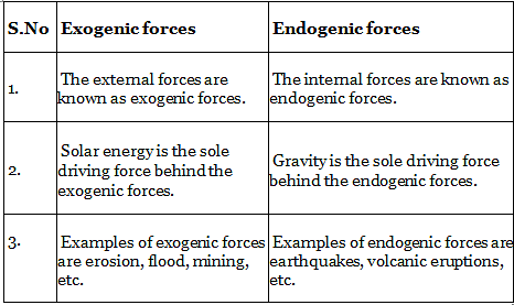
The country’s wetlands have been grouped into eight categories, They are:
(i) The reservoirs of the Deccan Plateau in the south together with the lagoons and other wetlands of the south west coast;
(ii) The vast saline expanses of Rajasthan, Gujarat and the Gulf of Kachchh;
(iii) Freshwater lakes and reservoirs from Gujarat eastwards through Rajasthan (Keoladeo National Park) and Madhya Pradesh;
(iv) The delta wetlands and lagoons of India’s east coast (Chilika Lake);
(v) The freshwater marshes of the Gangetic Plain;
(vi) The floodplains of the Brahmaputra; the marshes and swamps in the hills of northeast India and the Himalayan foothills;
(vii) The lakes and rivers of the montane region of Kashmir and Ladakh; and
(viii) The mangrove forest and other wetlands of the Andaman and Nicobar Islands’ island arcs. Mangroves grow along the coasts in the salt marshes, tidal creeks, mudflats and estuaries.
Q.22. What do you know about the flood-prone areas of India?
Ans: The states falling within the periphery of ‘India Flood Prone Areas’ are West Bengal, Odisha, Andhra Pradesh, Kerala, Assam, Bihar, Gujarat, Uttar Pradesh, Haryana and Punjab. The intense monsoons from the South-West cause the rivers like Brahmaputra, Ganga, Yamuna, etc., to swell their banks, which in turn floods the adjacent areas. Over the past decades, Central India has become familiar with the precipitation events like torrential rains and flash floods. The major flood-prone areas in India are the river banks and the deltas of Ravi, Yamuna-Sahibi, Gandak, Sutlej, Ganga, Ghaggar, Kosi, Teesta, Brahmaputra, Mahanadi, Mahananda, Damodar, Godavari, Mayurakshi, Sabarmati and their tributaries. During the rainy season, much of the water is wasted in floods and flows downs to the sea. Similarly, when there is a flood in one part of the country, the other area suffers from drought. The Godavari is subjected to heavy floods in its lower reaches to the south of Polavaram, where it forms a picturesque gorge.
Q.23. What do you know about the different types of earthquake waves?
Ans: Earthquake waves are of two types:
(i) Body waves: Body waves are generated due to the release of energy at the focus and move in all directions travelling through the body of the earth. Hence, the name body waves. Body waves are further divided into two types:
(a) P-waves: P-waves move faster and are the first to arrive at the surface. These are also called ‘primary waves’. The P-waves are similar to sound waves. They travel through gaseous, liquid and solid materials.
(b) S-waves: S-waves arrive at the surface with some time lag. These are called secondary waves. An important fact about S-waves is that they can travel only through solid materials. This characteristic of the S-waves is quite important. It has helped scientists understand the structure of the earth’s interior. Reflection causes waves to rebound whereas refraction makes waves move in different directions. The variations in the direction of waves are inferred with the help of their record on a seismograph. The surface waves are the last to report on seismographs. These waves are more destructive. They cause displacement of rocks, and hence, the collapse of structures occurs.
(ii) Surface waves: The body waves interact with the surface rocks and generate a new set of waves called surface waves. These waves move along the surface. These waves are more destructive. They cause displacement of rocks and hence, the collapse of structures occurs. The velocity of waves changes as they travel through materials with different densities. The denser the material, the higher is the velocity. Their direction also changes as they reflect or refract when coming across materials with different densities.
Q.24. What are the effects of the earthquake?
Ans: Earthquake is a natural hazard. The following are the immediate hazardous effects of earthquake:
(i) Ground shaking
(ii) Land and mudslides
(iii) Destruction of means of communication and transportation
(iv) Avalanches
(v) Ground displacement
(vi) Floods from dam and levee failures
(vii) Fire
(viii) Tsunami
Detailed Answer:
(i) Ground Shaking: Ground shaking is a hazard created by earthquakes and also triggers other hazards such as liquefaction and landslides. The ground-shaking is caused due to the seismic waves passing beneath buildings, roads and other structures.
(ii) Land and mudslides: When the earthquake occurs many times areas of steep slopes slip causing landslides. It also triggers the mass movement of the soil.
(iii) Destruction of means of communication and transportation: It leads to the destruction of means of communication and transportation. It creates problems in sending help and relief to the victims.
(iv) Avalanches: Large earthquakes can trigger avalanches by suddenly cascading or dislodging the snow from the mountain’s downside, which have catastrophic effects.
(v) Ground displacement: If a structure such as a building, road, etc., is built across a fault, the ground displacement during an earthquake could cause serious damage or rip apart that structure.
(vi) Floods from dam and levee failures: An earthquake can rupture or break dams or levees along a river. The water from the river or the reservoir would then flood the area, damaging buildings and maybe sweeping away or drowning people.
(vii) Fire: The fire can be started by broken gas lines and power lines or tipped over wood or coal stoves. There can be a serious problem, especially if the water lines that feed the hydrants are broken.
(viii)Tsunami: By and large the most destructive tsunamis are generated from large, shallow earthquakes with an epicentre or fault line near or on the ocean floor. These usually occur in regions of the earth characterized by tectonic subduction along tectonic plate boundaries.
Q.25. Explain the factors that control the temperature distribution of any place.
What do you know about the distribution of rainfall across the world?
Ans: The temperature of the air at any place is influenced by:
(i) the latitude of the place;
(ii) the altitude of the place;
(iii) distance from the sea, the air mass circulation;
(iv) the presence of warm and cold ocean currents;
(v) local aspects.
(i) The latitude: The latitude can be explained as an angular distance of a place North or South of the earth’s equator or of the equator of celestial objects usually expressed in degrees and minutes. The temperature of a place depends on the insolation received. The insolation varies according to the latitude hence the temperature also varies accordingly.
(ii) The altitude: The atmosphere is indirectly heated by terrestrial radiation from below. Therefore, the places near the sea-level record a higher temperature than the places situated at higher elevations. In other words, the temperature generally decreases with increasing height. The rate of decrease of temperature with height is termed as the normal lapse rate. It is 6.5°C per 1,000 m.
(iii) Distance from the sea: Another factor that influences the temperature is the location of a place with respect to the sea. Compared to land, the sea gets heated slowly and loses heat slowly. Land heats up and cools down quickly. Therefore, the variation in temperature over the sea is less compared to land. The places situated near the sea come under the sea’s moderating influence and land breezes, which moderate the temperature.
(iv) Air mass: An air mass is a volume of air defined by its temperature and water vapour content. Air masses may cover many hundreds or thousands of square miles and adapt to the characteristics of the surface below them. Like the land and sea breezes, air masses’ passage also affects the temperature. The places, which come under the influence of warm air masses experience higher temperature and the places that come under the influence of cold air masses experience low temperature.
(v) Ocean currents: An ocean current is a seasonal directed movement of seawater generated by forces acting upon this mean flow, such as breaking waves, wind, the Coriolis effect, temperature and salinity differences, while tides are caused by the gravitational pull of the sun and moon. the places located on the coast where the warm ocean currents flow record higher temperature than the places located on the coast where the cold currents flow.
After the condensation of water vapour, moisture release is known as precipitation. The salient features of the world distribution of precipitation are:
(i) Different places on the Earth’s surface receive different amounts of rainfall in a year and in different seasons. In general, as we proceed from the equator towards the poles, rainfall goes on decreasing steadily. The coastal areas of the world receive greater amounts of rainfall than the interior of the continents.
(ii) The rainfall is moreover the oceans than on the landmasses of the world because of being great sources of water. Between the latitudes 350 and 400 N and S of the Equator, the rain is heavier on the eastern coasts and goes on decreasing towards the west. But, between 450 and 650 N and S of the equator, due to the westerlies, the rainfall is first received on the western margins of the continents and it goes on decreasing towards the east. Wherever mountains run parallel to the coast, the rain is greater on the coastal plain, on the windward side and it decreases towards the leeward side.
(iii) On the basis of the total amount of annual precipitation, major precipitation regimes of the world are identified as follows. The equatorial belt, the windward slopes of the mountains along the western coasts in the cool temperate zone, and the monsoon land’s coastal areas receive heavy rainfall of over 200 cm per annum. Interior continental areas receive moderate rainfall varying from 100 - 200 cm per annum.
(iv) The continents’ coastal areas receive moderate amounts of rainfall. The central parts of the tropical land and the eastern and interior parts of the temperate lands receive rainfall varying between 50-100 cm per annum. Areas lying in the rain shadow zone of the interior of the continents and high latitudes receive very low rainfall-less than 50 cm per annum.
(v) Seasonal distribution of rainfall provides an important aspect to judge its effectiveness. In some regions, rainfall is distributed evenly throughout the year such as in the equatorial belt and in the western parts of cool temperate areas.
Q.26. Explain the structure of the atmosphere with the help of a labelled diagram.
Mention the steps taken to conserve the soil.
Ans: The atmosphere consists of different layers with varying density and temperature. Density is highest near the earth’s surface and decreases with increasing altitude. The atmosphere is divided into five distinct layers depending upon the temperature condition.
They are: troposphere, stratosphere, mesosphere, ionosphere and exosphere.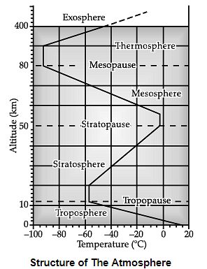
(i) Troposphere: The troposphere is the lowermost layer of the atmosphere. Its average height is 13 km and extends roughly to 8 km near the poles and about 18 km at the equator. The thickness of the troposphere is greatest at the equator because heat is transported to great heights by strong convection currents. This layer contains dust particles and water vapour. All changes in climate and weather take place in this layer. The temperature in this layer decreases at the rate of 1°C for every 165 m of height. This is the most important layer for all biological activity.
(ii) Stratosphere: The stratosphere is found above the tropopause and extends up to a height of 50 km. One important feature of the stratosphere is that it contains the ozone layer. This layer absorbs ultraviolet radiation and shields life on the earth from intense, harmful forms of energy.
(iii) Mesosphere: The mesosphere lies above the stratosphere, which extends up to a height of 80 km. In this layer, once again, the temperature starts decreasing with the increase in altitude and reaches up to minus 100°C at a height of 80 km.
(iv) Ionosphere: The ionosphere is located between 80 and 400 km above the mesopause. It contains electrically charged particles known as ions, and hence, it is known as the ionosphere. Radio waves transmitted from the earth are reflected back to the earth by this layer. The temperature here starts increasing with height.
(v) Exosphere: The uppermost layer of the atmosphere above the ionosphere is known as the exosphere. This is the highest layer but very little is known about it. Whatever contents are there, these are extremely rarefied in this layer, and it gradually merges with outer space. Although all layers of the atmosphere must influence us, geographers are concerned with the first two layers of the atmosphere.
If soil erosion and exhaustion are caused by humans; corollary, they can also be prevented by humans. Soil conservation is a methodology to maintain soil fertility, prevent soil erosion and exhaustion, and improve the degraded condition of the soil. Soil erosion is essentially aggravated by faulty practices.
The first step in any rational solution is to check open cultivable lands on slopes from farming. Lands with a slope gradient of 15 - 25 per cent should not be used for cultivation. If the land is to be used for agriculture at all, terraces should carefully be made.
Over-grazing and shifting cultivation in many parts of India have affected the natural cover of land and given rise to extensive erosion. It should be regulated and controlled by educating villagers about the consequences. Contour bunding, Contour terracing, regulated forestry, controlled grazing, cover cropping, mixed farming and crop rotation are some of the remedial measures which are often adopted to reduce soil erosion.
Efforts should be made to prevent gully erosion and control their formation. Finger gullies can be eliminated by terracing. In bigger gullies, the erosive velocity of water may be reduced by constructing a series of check dams.
Special attention should be made to control the headward extension of gullies. This can be done by gully plugging, terracing or by planting cover vegetation. In arid and semi-arid areas, efforts should be made to protect cultivable lands from encroachment by sand dunes through developing shelterbelts of trees and agroforestry. Lands not suitable for cultivation should be converted into pastures for grazing. Experiments have been made to stabilise sand dunes in western Rajasthan by the Central Arid Zone Research Institute (CAZRI).
Q.27. Explain the different types of soil erosion.
Ans: The different types of soil erosion are:
(i) Surface erosion: When rain, wind or frost detaches soil particles from the surface, they are washed or blown off the paddock.
(a) Sheet erosion: Sheet erosion takes place on level lands after a heavy shower, and the soil removal is not easily noticeable. But it is harmful since it removes the finer and more fertile topsoil. It lowers the fertility of the soil.
(b) Wind erosion: Wind erosion has the ability to remove soil and transport it. Wind erosion is significant in arid and semi-arid regions. In regions with heavy rainfall and steep slopes, erosion by running water is more significant.
(c) Water erosion: Water erosion which is more severe and occurs extensively in different parts of India, takes place mainly in the form of sheet and gully erosion. Sheet erosion occurs on level lands after a heavy shower and the soil removal is not easily noticeable. But it is harmful since it removes the finer and more fertile topsoil.
(ii) Fluvial erosion: This occurs when running water gouges shallow channels or deep gullies into the soil.
(a) Rill erosion: On sloping land, mainly if cultivated, water run-off may gather in small V-shaped channels or rills. These are particularly evident in pumice soils or those formed from loess but can occur on all hillsides.
(b) Gully erosion: Gully erosion is common on steep slopes. It occurs on unconsolidated subsoils. Gullies deepen with rainfall, cut the agricultural lands into small fragments and make them unfit for cultivation. A region with many deep gullies or ravines is called a badland topography. Ravines are widespread in the Chambal basin. Besides this, they are also found in Tamil Nadu and West Bengal.
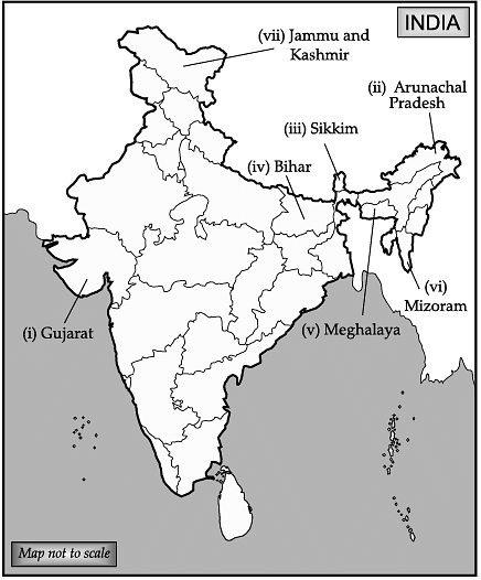
Q.28. On the given map of India, locate and label any five of the following:
(i) a state which shares its border with Pakistan.
(ii) a state which shares its border with China.
(iii) a state which shares its border with Bhutan.
(iv) a state which shares its border with Nepal.
(v) a state which shares its border with Bangladesh.
(vi) a state which shares its border with Myanmar.
(vii) a state which shares its border with Afghanistan.
Ans:
(i) Gujarat
(ii) Arunachal Pradesh
(iii) Sikkim
(iv) Bihar
(v) Meghalaya
(vi) Mizoram
(vii) Jammu and Kashmir
Q.29. Identify and label the following five features in an outline map of the world.
(i) A tectonic plate between the Asiatic and Pacific plate.
(ii) A tectonic plate between Central America and Pacific plate.
(iii) A tectonic plate between South America and the Pacific plate.
(iv) The tectonic plate in the Saudi Arabian landmass.
(v) A tectonic plate between the Philippine and Indian plate.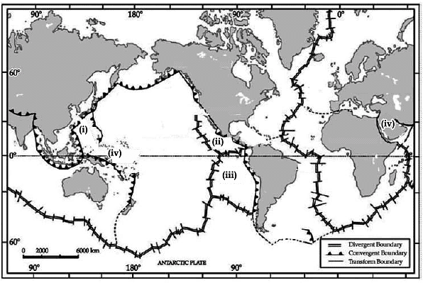
Ans:
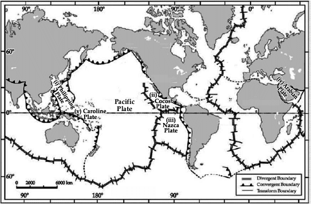 (i) Philippine plate
(ii) Cocos Plate
(iii) Nazca plate
(iv) Arabian plate
(v) Caroline plate.
|
75 videos|237 docs|45 tests
|
FAQs on Geography: CBSE Sample Question Paper - 1 - Geography for Grade 11
| 1. What are the major landforms found in India? |  |
| 2. How does the monsoon affect India's climate? |  |
| 3. What are the different types of forests found in India? |  |
| 4. How does the Ganga River contribute to India's geography? |  |
| 5. What are the major natural disasters that occur in India due to its geography? |  |

|
Explore Courses for Grade 11 exam
|

|


