Class 9 Exam > Class 9 Notes > Social Studies (SST) Class 9 > Glossary and Important Information - Physical Features of India
Glossary and Important Information - Physical Features of India | Social Studies (SST) Class 9 PDF Download
| Table of contents |
|
| Glossary |
|
| Important Information |
|
| Major Physiographic Divisions |
|
| The Himalayan Mountains |
|
| The Northern Plains |
|
| Peninsular Plateau |
|
| The Indian Desert |
|
| The Coastal Plains |
|
| The Islands |
|

Glossary
- Tarai Zone: It is a Zone next to the bhabar which is wet and marshy. It has a thick forest cover with a variety of wildlife.
- Water divide: The upland that separates the flow of two rivers or river systems.
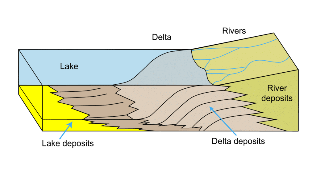
- Delta: It is a triangular deposition of sediment at the mouth of a river. The river becomes slow at the mouth of the sea, so mud and silt settle down and from the delta.
- Estuary: It is a narrow deep valley at the mouth of a river where currents or tides are strong or the current of the river itself is swift.
- Tributary: A river that joins the main river and increases the volume of water.
- Plate Tectonic: The scientific concept which explains the movements of the different plates of the crust of the earth.
- Gondwana land: A major portion of the crust that once incorporated Australia, Peninsular India South Africa and South America.
- Tethys Sea: A narrow sea with a sinking bottom lying between Gondwana land in the south and Angara land in the north.
Question for Glossary and Important Information - Physical Features of IndiaTry yourself: What is the definition of a tributary?View Solution
- Flood Plain: A plain formed by the sediment deposited by the rivers year after year.
- Bar: A deposit of sand or mud in the river channel.
- Levees: An elevated bank flanking the channel of a river and standing above the level of the flood plains.
- Lagoon: A saltwater lake separated from the sea by the sandbars.
- Glacier: Slow-moving rivers of snow & ice.
 Glacier
- Pass: A gap in mountain range providing a natural route across.
- Alluvial Plains: Flat low-lying lands made of alluvium.
- Diverging Plate: Plates that are moving away from each other.
- Converging Plate: Plates that are coming together.
- Perennial Rivers: Rivers which flow throughout the year.
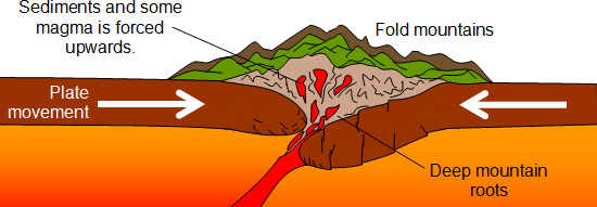
- Fold Mountain: The fold mountains formed during the most recent major phase of folding in the earth’s crust.
- Coral Polyps: Coral polyps are short-lived microscopic organisms which live in colonies.
- A Distributary: A distributary is a river that originates from the main river. It is formed near the river's mouth before it falls into the sea.
- Gorge: The steep-sided narrow and deep valley of a river formed in its upper course is termed a Gorge or a Canyon. It is also called an I–shaped valley.
Example: The Brahmaputra Gorge (5500m), and the Indus Gorge. - A Rift Valley: A rift valley is a valley that has been formed as a result of the subsidence (sinking) of the landmass between two blocks due to faulting.
- Sand Dune: A mound ridge, or low hill of loose, windblown sand.
Important Information
India is a vast country with varied landforms which has all major physical features of the earth i.e. mountains, plains, deserts, plateaus and islands.
Major Physiographic Divisions
The physical features of India can be grouped under the following physiographic divisions:
The Himalayan Mountains
- It is geologically young and structurally folded mountains that run along the northern borders of India.
- The ranges extend from the west (near the Indus River) to the east (toward the Brahmaputra) covering a distance of about 2,400 Km representing some of the highest peaks in the world, particularly in the Himalayas.
- Width varies from 400 Km in Kashmir to 150 Km in Arunachal Pradesh. Altitude (Height) variations are greater in the eastern half than those in the western half.
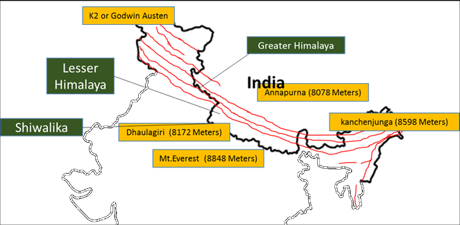
- Longitudinal divisions of the Himalayas:

The Great or Inner Himalayas or the 'Himadri'
- It is the northernmost range and most continuous range consisting of the loftiest peaks with an average height of 6,000 metres.
- It contains all the famous peaks. The folds are asymmetrical in nature.
- The basic part of the Himalayas is composed of granite.
- It is perennially snowing bound, and a number of glaciers descend from this range.
Question for Glossary and Important Information - Physical Features of IndiaTry yourself: What is a flood plain?View Solution
The lesser Himalayas or 'Himachal'
- It lies south of the Himadri and forms the most rugged mountain system.
- It is mainly composed of highly compressed and altered rocks.
- The height varies between 3,700 and 4,500 metres and the average width is 50 Km.
- The longest and most important ranges are the PirPanjal range and Dhaula Dhar and the Mahabharat ranges.
- Famous valleys of this range are the Kashmir, the Kangra and the Kullu Valley in Himachal Pradesh. Also, this range is famous for hill stations.
The Shiwaliks
- This is the outermost range of the Himalayas.
- They extend over a width of 10-50 Km and have a height varying between 900 and 1100 metres.
- It is composed of unconsolidated sediments brought down by rivers from the main Himalayan ranges.
- These valleys are covered with thick gravel and alluvium.
- The longitudinal valley lying between the lesser Himalayas and the Shiwaliks is known as Duns.
- Dehra Dun, Kotli Dun and Patli Dun are some of the well-known Duns.
- Himalayas divisions based on regions from east to west (divisions have been made by the river valleys)
The Northern Plains
- The northern plain has been formed by the interplay of three major river systems namely- the Indus, the Ganga and the Brahmaputra along with its tributaries.
- It is formed of Alluvial soil.
- The vast basin lying at the foothills of the Himalayas was deposited with alluvium (fine particles of silt and clay and larger particles of sand and gravel) over a million years and formed this plain.
- Area of Northern Plain: 7 lakh sq. km. Length of Northern Plain: 2400 km. The breadth of the Northern Plain: 240 to 320 km.
- It is a densely populated region. It is an agriculturally very productive region of India due to rich soil cover combined with an adequate water supply and favourable climate.
- The rivers coming from the northern mountains brought a huge amount of eroded soil which helped in the depositional work.
- In the lower course, due to the gentle slope, the velocity of the river decreases which results in the formation of riverine islands (An Island formed by the river).
- Also, in the lower course, rivers split into numerous channels due to the deposition of silt known as distributaries.
- The Northern Plain is broadly divided into three parts:
- The Punjab Plains: The Western part of the Northern Plain, formed by the Indus and its tributaries, the larger part of this plain lies in Pakistan
- The Ganga Plains: It extends between the Ghaggar and Tista rivers. spread over the states of north India, Haryana, Delhi, U.P., Bihar, party Jharkhand and West Bengal.
- The Brahmaputra Plains: Lies in the east of the Ganga plain, particularly in Assam.
- Northern Plain is not flat land. The vast plains also have diverse relief features.
Peninsular Plateau
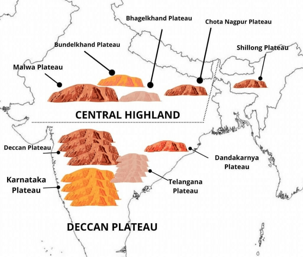
- The Peninsular Plateau is a tableland composed of old crystalline, igneous and metamorphic rocks.
- It was formed due to the breaking and drifting of the Gondwana land.
- The plateau consists of two broad divisions: The Central Highlands & The Deccan Plateau
The Central Highlands
The Central Highlands
- It lies to the north of the Narmada river covering a major area of the Malwa plateau.
- The Vindhyan range is bounded by the Central Highlands on the south and the Aravalis on the northwest.
- The further westward extension gradually merges with the sandy and rocky desert of Rajasthan.
- Rivers in this area: the Chambal, the Sind, the Betwa and Ken.
- The Central Highlands are wider in the west but narrower in the east.
- The eastward extensions of this plateau are locally known as the Undelkhand and Baghelkhand.
- The Chotanagpur plateau marks the further eastward extension, drained by the Damodar river
The Deccan Plateau
- It is a triangular landmass that lies to the south of the river Narmada.
- The Satpura range bound its broad base in the north while the Mahadev, the Kaimur hills and the Maikal range form its eastern extensions.
- It is higher in the west and slopes gently eastwards.
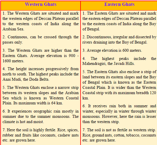
- The Western Ghats and the Eastern Ghats mark the western and the eastern edges of the Deccan Plateau respectively.
Question for Glossary and Important Information - Physical Features of IndiaTry yourself: What is the composition of the lesser Himalayas?View Solution
The Indian Desert
- The Indian desert lies towards the western margins of the Aravali Hills.
- It is a land of undulating topography covered with sand dunes.
- This region receives very low rainfall below 150 mm per year.
- It has an arid climate with low vegetation cover.
- Luni is the only large river in this region
- Barchans (crescent-shaped dunes) cover larger areas but longitudinal dunes become more prominent near the Indo-Pakistan boundary.
The Coastal Plains
- The narrow coastal strips flank the Peninsular Plateau, running along the Arabian Sea on the west and the Bay of Bengal on the east.
- It consists of three sections:
The northern part of the coast is called the Konkan (Mumbai – Goa)
Central stretch is called the Kannad Plain
The southern stretch is called the Malabar Coast. - The plains along the Bay of Bengal (east part) are wide and level.
- The northern part is known as the Northern Circar, while the southern part is known as the Coromandel Coast.
- Large rivers such as the Mahanadi, the Godavari, the Krishna and the Kaveri have formed extensive delta on the eastern coast.
- Lake Chilika is an important feature along the eastern coast.
The Islands
- Lakshadweep Islands- This group of islands is composed of small coral islands.
- The Lakshadweep Islands were earlier known as Laccadive, Minicoy and Amindive.
- It covers a small area of 32 sq km.
- Kavaratti Island is the administrative headquarters of Lakshadweep.
- The Pitti island, which is uninhabited, has a bird sanctuary.
- The Andaman and Nicobar Islands are an elongated chain of islands located in the Bay of Bengal.
- They are bigger in size and are more numerous and scattered.
- The entire group of islands is divided into two broad categories –The Andaman in the north and the Nicobar in the south.
- These islands are an elevated portion of submarine mountains.
The document Glossary and Important Information - Physical Features of India | Social Studies (SST) Class 9 is a part of the Class 9 Course Social Studies (SST) Class 9.
All you need of Class 9 at this link: Class 9
|
55 videos|525 docs|78 tests
|
FAQs on Glossary and Important Information - Physical Features of India - Social Studies (SST) Class 9
| 1. What are the major physiographic divisions of India? |  |
Ans. The major physiographic divisions of India include the Himalayan Mountains, the Northern Plains, the Peninsular Plateau, the Indian Desert, the Coastal Plains, and the Islands. Each of these divisions has distinct geographical features, climate, and ecosystems.
| 2. How do the Himalayan Mountains influence the climate of India? | |
Ans. The Himalayan Mountains act as a barrier to cold winds from Central Asia, preventing them from entering India. This results in a milder climate in the Indian subcontinent. Additionally, they play a crucial role in the monsoon pattern, as they cause the southwest monsoon winds to rise, leading to heavy rainfall in the region.
| 3. What are the characteristics of the Northern Plains of India? | |
Ans. The Northern Plains are characterized by their fertile alluvial soil, extensive river systems, and a flat topography. This region is crucial for agriculture, supporting the cultivation of various crops. The major rivers, including the Ganges, Yamuna, and Brahmaputra, flow through this area, providing irrigation and supporting biodiversity.
| 4. What is the significance of the Peninsular Plateau in India? | |
Ans. The Peninsular Plateau is significant for its rich mineral resources and diverse ecosystems. It is bordered by the Western and Eastern Ghats, which are important for biodiversity. The plateau's elevation and geological features also influence the climate and river systems in the region, making it vital for agriculture and water resources.
| 5. How do the Coastal Plains of India differ from the Indian Desert? | |
Ans. The Coastal Plains are characterized by flat, low-lying areas along the coastline, with fertile soil and a humid climate, supporting agriculture and fishing. In contrast, the Indian Desert, primarily the Thar Desert, is characterized by arid conditions, sandy soil, and sparse vegetation, making it challenging for agriculture and habitation.
About this Document

16.4K Views

4.66/5
Rating

Oct 12, 2025
Last updated
Document Description: Glossary and Important Information - Physical Features of India for Class 9 2025 is part of Social Studies (SST) Class 9 preparation.
The notes and questions for Glossary and Important Information - Physical Features of India have been prepared according to the Class 9 exam syllabus. Information about Glossary and Important Information - Physical Features of India covers topics
like Glossary , Important Information, Major Physiographic Divisions , The Himalayan Mountains, The Northern Plains, Peninsular Plateau, The Indian Desert , The Coastal Plains, The Islands and Glossary and Important Information - Physical Features of India Example, for Class 9 2025 Exam. Find important definitions, questions, notes, meanings, examples, exercises and tests below for Glossary and Important Information - Physical Features of India.
Introduction of Glossary and Important Information - Physical Features of India in English is available as part of our Social Studies (SST) Class 9
for Class 9 & Glossary and Important Information - Physical Features of India in Hindi for Social Studies (SST) Class 9 course.
Download more important topics related with notes, lectures and mock test series for Class 9
Exam by signing up for free. Class 9: Glossary and Important Information - Physical Features of India | Social Studies (SST) Class 9
Description
Full syllabus notes, lecture & questions for Glossary and Important Information - Physical Features of India | Social Studies (SST) Class 9 - Class 9 | Plus excerises question with solution to help you revise complete syllabus for Social Studies (SST) Class 9 | Best notes, free PDF download
Information about Glossary and Important Information - Physical Features of India
In this doc you can find the meaning of Glossary and Important Information - Physical Features of India defined & explained in the simplest way possible. Besides explaining types of
Glossary and Important Information - Physical Features of India theory, EduRev gives you an ample number of questions to practice Glossary and Important Information - Physical Features of India tests, examples and also practice Class 9
tests

Related Searches
Important questions
,Previous Year Questions with Solutions
,study material
,Semester Notes
,Viva Questions
,ppt
,mock tests for examination
,video lectures
,Summary
,practice quizzes
,Objective type Questions
,Exam
,Glossary and Important Information - Physical Features of India | Social Studies (SST) Class 9
,shortcuts and tricks
,MCQs
,Sample Paper
,past year papers
,Free
,Glossary and Important Information - Physical Features of India | Social Studies (SST) Class 9
,Extra Questions
,Glossary and Important Information - Physical Features of India | Social Studies (SST) Class 9
;


Additional Information about Glossary and Important Information - Physical Features of India for Class 9 Preparation
Glossary and Important Information - Physical Features of India Free PDF Download
The Glossary and Important Information - Physical Features of India is an invaluable resource that delves deep into the core of the Class 9 exam.
These study notes are curated by experts and cover all the essential topics and concepts, making your preparation more efficient and effective.
With the help of these notes, you can grasp complex subjects quickly, revise important points easily,
and reinforce your understanding of key concepts. The study notes are presented in a concise and easy-to-understand manner,
allowing you to optimize your learning process. Whether you're looking for best-recommended books, sample papers, study material,
or toppers' notes, this PDF has got you covered. Download the Glossary and Important Information - Physical Features of India now and kickstart your journey towards success in the Class 9 exam.
Importance of Glossary and Important Information - Physical Features of India
The importance of Glossary and Important Information - Physical Features of India cannot be overstated, especially for Class 9 aspirants.
This document holds the key to success in the Class 9 exam.
It offers a detailed understanding of the concept, providing invaluable insights into the topic.
By knowing the concepts well in advance, students can plan their preparation effectively.
Utilize this indispensable guide for a well-rounded preparation and achieve your desired results.
Glossary and Important Information - Physical Features of India Notes
Glossary and Important Information - Physical Features of India Notes offer in-depth insights into the specific topic to help you master it with ease.
This comprehensive document covers all aspects related to Glossary and Important Information - Physical Features of India.
It includes detailed information about the exam syllabus, recommended books, and study materials for a well-rounded preparation.
Practice papers and question papers enable you to assess your progress effectively.
Additionally, the paper analysis provides valuable tips for tackling the exam strategically.
Access to Toppers' notes gives you an edge in understanding complex concepts.
Whether you're a beginner or aiming for advanced proficiency, Glossary and Important Information - Physical Features of India Notes on EduRev are your ultimate resource for success.
Glossary and Important Information - Physical Features of India Class 9 Questions
The "Glossary and Important Information - Physical Features of India Class 9 Questions" guide is a valuable resource for all aspiring students preparing for the
Class 9 exam. It focuses on providing a wide range of practice questions to help students gauge
their understanding of the exam topics. These questions cover the entire syllabus, ensuring comprehensive preparation.
The guide includes previous years' question papers for students to familiarize themselves with the exam's format and difficulty level.
Additionally, it offers subject-specific question banks, allowing students to focus on weak areas and improve their performance.
Study Glossary and Important Information - Physical Features of India on the App
Students of Class 9 can study Glossary and Important Information - Physical Features of India alongwith tests & analysis from the EduRev app,
which will help them while preparing for their exam. Apart from the Glossary and Important Information - Physical Features of India,
students can also utilize the EduRev App for other study materials such as previous year question papers, syllabus, important questions, etc.
The EduRev App will make your learning easier as you can access it from anywhere you want.
The content of Glossary and Important Information - Physical Features of India is prepared as per the latest Class 9 syllabus.
|
© EduRev
|
Education Revolution
|


|


Signup to see your scores
go up within 7 days!
Access 1000+ FREE Docs, Videos and Tests
Takes less than 10 seconds to signup