Past Year Questions: Tacheometric, Curve, Hydrographic and Plane Table Surveying & Theory of Errors | Topic wise GATE Past Year Papers for Civil Engineering - Civil Engineering (CE) PDF Download
Q1: A delivery agent is at a location R. To deliver the order, she is instructed to travel to location P along straight-line paths of RC, CA, AB and BP of 5 km each. The direction of each path is given in the table below as whole circle bearings. Assume that the latitude (L) and departure (D) of R is (0, 0)km. What is the latitude and departure of P (in km, rounded off to one decimal place)? [2023, Set-II]
(a) L = 2.5 ; D = 5.0
(b) L = 0.0 ; D = 5.0
(c) L = 5.0 ; D = 2.5
(d) L = 0.0 ; D = 0.0
Ans: (b)


Q2: The direct and reversed zenith angles observed by a theodolite are 56∘00′ 00′′ and 303∘ 00′ 00′′, respectively. What is the vertical collimation correction? [2023, Set-I]
(a) +1∘ 00′ 00′′
(b) −1∘ 00′ 00′′
(c) −0∘ 30′ 00′′
(d) +0∘ 30′ 00′′
Ans: (d) In above example of both direct zenith angle and reversed zerwith angle are smaller than true value.
Q3: The diameter and height of a right circular cylinder are 3 cm and 4 cm, respectively. The absolute error in each of these two measurements is 0.2 cm. The absolute error in the computed volume (in cm3 , round off to three decimal places), is _______. [2020, Set-II]
(a) 1.65
(b) 7.52
(c) 3.25
(d) 5.18
Ans: (d)
Let diameter, x = 3 and height = y = 4 and error = ±0.2
Q4: A series of perpendicular offsets taken from a curved boundary wall to a straight survey line at an interval of 6m are 1.22, 1.67, 2.04, 2.34, 2.14, 1.87, and 1.15 m. The area (in m2 , round off to 2 decimal places) bounded by the survey line, curved boundary wall, the first and the last offsets, determined using Simpson's rule, is _______ [2019, Set-II]
(a) 35.50
(b) 45.25
(c) 68.50
(d) 75.45
Ans: (c) Area by Simpson's rule
Q5: Consider the hemi-spherical tank of radius 13 m as shown in the figure. What is the volume of water (in m3) when the depth of water at the centre of the tank is 6 m? [2019, Set-II] (a) 78π
(b) 156π
(c) 396π
(d) 468π
Ans: (c)
Volume of water

Q6: The method of orientation used, when the plane table occupies a position not yet located on the map, is called as [2017 : 1 Mark, Set-II]
(a) traversing
(b) radiation
(c) levelling
(d) resection
Ans: (d)
1. Traversing: 'Traverse’ means to pass across. Traversing refer to the framework of series of lines forming an open or closed polygon.
2. Radiation: It is a method of locating a point by drawing a radial line from the plane table station to the station under consideration.
3. Levelling: It is the method of determining the difference of elevations or levels of different points on the earth’s surface.
4. Resection:It is the method of locating a station occupied by the plane table when the position of that station has not been plotted earlier on the sheet when the plane table occupied other station
Q7: The VPI (vertical point of intersection) is 100 m away (when measured the horizontal) from the VPC (vertical point of curvature). If the vertical curve parabolic, the length of the curve (in meters and measured along the horizontal) is ________. [2017 :1 Mark, Set-II]
Ans:
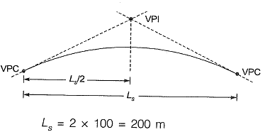
Q8: A circular curve of radius R connects two straights with a deflection angle of 60°. The tangent length is [2016 : 1 Mark, Set-II]
(a) 0.577 R
(b) 1.155 R
(c) 1.732 R
(d) 3.464 R
Ans: (a)
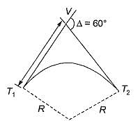
Tangent length

Q9: In a survey work, three independent angles, X, Y and Z were observed with weights Wx, WY, Wz, respectively. The weight of the sum of angles X, Y and Z is given by [2015 : 2 Marks, Set-T]

Ans: (a)
Various laws of weight
Let there be quantities A and B with weight Wa and Wb respectively
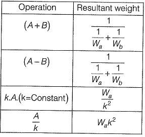
Q10: The chainage of the intersection point of two straights is 1585.60 m and the angle of intersection is 140°. If the radius of a circular curve is 600.00 m, the tangent distance (in m) and length of the curve (in m), respectively are [2014 : 2 Marks, Set-II]
(a) 418.88 and 1466.08
(b) 218.38 and 1648.49
(c) 218.88 and 418.82
(d) 418.88 and 218.38
Ans: (c)
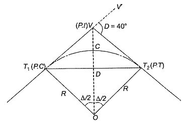
Δ = 180° - 140° = 40°
Length of the curve
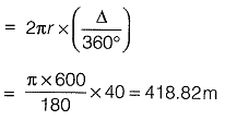
Tangent distance (7) is the distance between
P-C to P.I (also the distance from P.I to P. T)
⇒ T = T1V

= 600 tan 20° = 218.88 m
Q11: A tacheometer was placed at point P to estimate the horizontal distances PQ and PR. The corresponding stadia intercepts with the telescope kept horizontal, are 0.320 m and 0.210 m, respectively. The ∠QPR is measured to be 61° 30' 30". If the stadia multiplication constant = 100 and stadia addition constant = 0.10 m, the horizontal distance (in m) between the points Q and R is ______. [2014 : 2 Marks, Set-II]
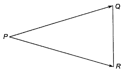
Ans:
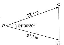
PQ = ks + C
= 100(0.32) + 0.1 = 32.1 m
PR = ks + C
= 100(0.21) + 0.1 = 21.1 m
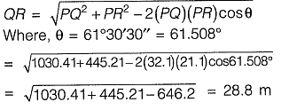
Applying the cosine rule
FAQs on Past Year Questions: Tacheometric, Curve, Hydrographic and Plane Table Surveying & Theory of Errors - Topic wise GATE Past Year Papers for Civil Engineering - Civil Engineering (CE)
| 1. What is tacheometric surveying and how is it different from traditional surveying methods? |  |
| 2. What are the key components of curve surveying in civil engineering? |  |
| 3. How does hydrographic surveying differ from other types of surveying? |  |
| 4. What is the significance of the theory of errors in surveying? |  |
| 5. What are the common applications of plane table surveying in modern engineering projects? |  |

|
Explore Courses for Civil Engineering (CE) exam
|

|


