Revision Notes - Distribution of Oceans and Continents


Continental Drift
Continental Drift is the theory proposed by Alfred Wegener that continents were once part of a single landmass and have since drifted to their present positions. The idea was proposed by Alfred Wegener, a German meteorologist, in 1912 to explain the present distribution of oceans and continents.
- Wegener suggested that all the continents were once joined together as a single supercontinent called Pangaea (meaning "all Earth").
- The supercontinent was surrounded by a single immense ocean named Panthalassa (meaning "all water").
- About 200 million years ago Pangaea began to break apart into two large landmasses: Laurasia in the north and Gondwanaland in the south; these later fragmented into the continents seen today.
Evidence in Support of Continental Drift
Matching of Continental Margins (Jigsaw Fit)
- The coastlines of western Africa and eastern South America fit together in a jigsaw-like manner when continental shelves are considered rather than present-day shorelines.
- In 1964, Bullard used a computer programme to align the Atlantic margins at the 1,000-fathom line (about the edge of the continental shelf). This produced an almost perfect fit, supporting the view that these continents were once joined.
Correlation of Rock Formations
- Radiometric dating and stratigraphic studies show the presence of rocks of similar age and character on coastlines now separated by oceans.
- For example, a belt of ancient rocks about 2,000 million years old on the coast of Brazil matches rocks in western Africa.
- Earliest marine deposits along coasts of South America and Africa are of Jurassic age; this suggests the Atlantic Ocean opened after these deposits formed.
Tillite and Glacial Evidence
- Tillite is a sedimentary rock formed from glacial deposits (till) and indicates past glaciation.
- The Gondwana sedimentary sequence in India includes thick tillite layers at its base, and similar Gondwana-type successions occur in Africa, the Falkland Islands, Madagascar, Antarctica, and Australia.
- The wide distribution and similarity of these glacial deposits suggest these southern landmasses were once contiguous and experienced the same palaeoclimates.
Placer Deposits
- Placer deposits are concentrations of heavy minerals (for example, gold) formed by mechanical concentration in river and coastal environments.
- Rich gold placers on the coast of Ghana occur despite a lack of local source rock; similar gold-bearing veins exist in Brazil, implying those deposits may have been derived when South America and Africa were joined.
Distribution of Fossils
- Identical or closely related fossil species adapted to land or freshwater are found on different continents now separated by oceans-this is difficult to explain by oceanic dispersal alone.
- Examples include Mesosaurus, a small reptile found only in the Southern Cape of South Africa and the Irati Formation of Brazil, though these sites are now about 4,800 km apart; their presence supports former land connection.
- Fossil distribution of some plants and other animals (for example, lemur-like fossils across India, Madagascar and Africa) led to the idea of a contiguous landmass (Lemuria) linking these regions.
Try yourself: According to the Plate Tectonic concept, how many major plates are there?
Forces Proposed for Drifting
- Wegener proposed mechanisms such as the pole-fleeing force (arising from Earth's rotation) and tidal forces from the Moon and Sun to explain continental movement.
- The pole-fleeing effect relates to centrifugal force that creates an equatorial bulge because Earth is not a perfect sphere.
- Wegener believed these forces acting over long time periods would move continents; however, most contemporary geophysicists considered these forces insufficient and rejected his mechanism.
Post-Drift Studies and Advances
After World War II, new observations-especially from oceanographic surveys-added crucial evidence and led to the development of plate tectonics as a comprehensive theory. Key developments are described below.
Convection Current Theory
- Arthur Holmes (1930s) proposed that heat from radioactive decay in Earth's interior creates convection currents in the mantle.
- These currents involve hotter, less dense material rising and cooler, denser material sinking, producing circular flow that can exert forces on the overlying lithosphere.
- Holmes suggested that such mantle convection could provide a plausible force to move continents-an idea that later fed into sea-floor spreading and plate tectonics concepts.
Mapping of the Ocean Floor
- Ocean floor mapping revealed that the seabed has varied relief: mid-ocean ridges, abyssal plains, and deep-ocean trenches.
- Mid-ocean ridges were found to be zones of volcanic activity and new crust formation.
- Radiometric dating showed that oceanic crust is generally much younger than continental crust, and rocks on either side of a ridge at equal distances are of similar age and composition.
Ocean Floor Configuration
The ocean floor is generally divided into three major parts based on depth, relief and geological processes.
- Continental Margins - the transition between continental shelves and the deep ocean; include the shelf, slope and rise, and, in active margins, deep-ocean trenches.
- Abyssal Plains - broad, flat areas of the deep ocean that receive sediment derived from continents; typically lie between continental margins and mid-ocean ridges.
- Mid-Ocean Ridges - extensive, interconnected submarine mountain chains that form the longest continuous mountain system on Earth and typically feature a central rift valley.
Continental Margins
- Mark the boundary between continental crust and oceanic crust.
- Passive margins (e.g., eastern North America) are wide with broad shelves; active margins (e.g., western Pacific margins) are tectonically active and commonly feature trenches and volcanic arcs.
Abyssal Plains
- Formed by the settling of fine sediments over the oceanic crust; among the flattest natural surfaces on Earth.
- They accumulate sediments transported from continents and biological remains.
Mid-Oceanic Ridges
- Characterised by a central rift valley where new oceanic crust is formed by upwelling magma and volcanic activity.
- Ridges have fracture zones and transform faults along their flanks; they are significant sites of sea-floor spreading.
Distribution of Earthquakes and Volcanoes
- Most earthquakes and volcanic activity are concentrated along plate boundaries because of relative plate motions.
- Earthquakes at mid-ocean ridges are generally shallow; deep-focus earthquakes occur in subduction zones such as those around the Pacific Rim.
- The Pacific margin with its frequent volcanic and seismic activity is referred to as the Ring of Fire.
Concept of Sea-Floor Spreading
- Sea-floor spreading was proposed by Harry Hess in 1961. It describes the process by which new oceanic crust forms at mid-ocean ridges and moves laterally away from the ridge crest.
- Hess argued that continuous volcanic eruptions at ridge crests create new crust that pushes older crust away; the ocean floor is therefore continuously renewed.
- Because oceanic crust is eventually consumed in trenches (subduction), sea-floor spreading provides a mechanism for the recycling of oceanic lithosphere into the mantle.
Plate Tectonics
Plate tectonics is the unifying theory that describes the motion of several large and small rigid lithospheric plates that move on the ductile asthenosphere beneath them. The modern formulation of the theory was proposed by McKenzie, Parker and Morgan in 1967.
- The lithosphere comprises the crust and the uppermost mantle and is broken into plates that vary in size and shape.
- The lithosphere moves horizontally over the asthenosphere, which is relatively softer and can flow slowly.
- Lithospheric thickness varies from about 5-100 km in oceanic areas and about 200 km in continental areas.
Major Plates
- Pacific Plate
- North American Plate
- South American Plate
- African Plate
- Eurasian Plate
- India-Australia-New Zealand Plate
- Antarctic Plate
Minor Plates
- Cocos Plate - between Central America and the Pacific Plate
- Nazca Plate - between South America and the Pacific Plate
- Arabian Plate - largely the Arabian Peninsula
- Philippine Plate - between the Eurasian and Pacific Plates
- Caroline Plate - north of New Guinea, between the Philippine and Pacific regions
Plates have been moving throughout geological time. Wegener's idea of past continental convergence forming Pangaea is consistent with plate-tectonic reconstructions of past continental positions; in some cases, local geological evidence (for example, ancient rocks in regions such as the Nagpur area) contributes to reconstructing past plate positions.
Try yourself: The boundary in the given picture shows the
Types of Plate Boundaries
Three primary types of plate boundaries are recognised. Each has distinct geological processes and landform associations.
Divergent Boundaries
- Where two plates move apart and new crust is generated by upwelling magma.
- These sites are called spreading centres; a classic example is the Mid-Atlantic Ridge, which separates the American Plate(s) from the Eurasian and African Plates.
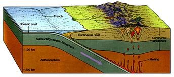
Convergent Boundaries
- Where plates move toward each other and crust is consumed.
- A subduction zone is where an oceanic plate sinks beneath another plate (either oceanic or continental), producing deep trenches, volcanic arcs, and earthquakes.
- Convergence occurs in three broad ways: oceanic-continental, oceanic-oceanic, and continental-continental collision (the last produces large mountain belts such as the Himalayas).
Transform Boundaries
- Where plates slide horizontally past one another and crust is neither created nor destroyed.
- Transform faults commonly offset mid-ocean ridges and are often roughly perpendicular to the ridge axis.
- Volcanic activity is not typical along long transform faults, but earthquakes are common due to built-up shear stress.
Rates of Plate Movement
- Rates of plate movement are determined using magnetic striping on the ocean floor, radiometric dating, and direct measurements by geodetic techniques (for example, GPS).
- Magnetic stripes of normal and reversed polarity parallel to ridges record the history of seafloor spreading and allow calculation of long-term rates.
- Typical rates vary from less than 2.5 cm/year (e.g., some sections of the Arctic Ridge) to more than 15 cm/year (e.g., parts of the East Pacific Rise near Easter Island).
Forces Driving Plate Movement
- Plate movement is driven by convection currents in the mantle caused by heat from radioactive decay and residual heat.
- Slab pull arises when a dense oceanic plate sinks into the mantle at a subduction zone, pulling the trailing plate along.
- Ridge push is the gravitational force that pushes lithosphere away from the elevated mid-ocean ridge toward lower regions.
- Overall, heat from radioactive decay and residual formation heat drives convective flow in the mantle, which in turn contributes to plate motions. The convection idea was first clearly advocated by Arthur Holmes in the 1930s and later incorporated into plate-tectonic models.
Movement of the Indian Plate
- The Indian Plate includes Peninsular India and parts of continental fragments that have been associated with its motion; it has also been classed with Australia as the India-Australia plate in many reconstructions.
- India was once located much farther south; about 140 million years ago the Indian subcontinent lay near 50°S latitude and was separated from Asia by the Tethys Sea.
- India began moving northwards about 200 million years ago and is believed to have collided with the Asian plate approximately 40-50 million years ago, initiating the uplift of the Himalayas.
- During its northward drift, massive volcanic eruptions formed the Deccan Traps, beginning around 60 million years ago; these eruptions occurred when the subcontinent was near the equator.
- The northern margin of the Indian Plate is characterised by continent-continent convergence against Eurasia (the Himalayan orogenic boundary).
- To the east, plate boundaries extend through regions including Myanmar and the island arcs towards the Java Trench; to the west the plate boundary passes near the Kirthar range and extends into the Indian Ocean rift and spreading centres toward the Chagos Archipelago and the Red Sea rift system.
- The plate boundary between India and the Antarctic Plate is marked by an oceanic ridge that trends roughly west-east and links into spreading centres south of New Zealand.
- India's northward motion, collision with Asia, and ongoing convergence are responsible for continued seismicity and the ongoing uplift of the Himalayan mountain system.
Try yourself: The continental drift theory was propounded by
Conclusion
This chapter outlines how the distribution of oceans and continents is explained by the movement of lithospheric plates over geological time. The continental drift hypothesis pioneered the idea of mobile continents. Subsequent evidence from matching coastlines, correlated rock formations, fossil distributions, glacial deposits (tillites), and ocean floor mapping led to mechanisms such as sea-floor spreading and the fully developed plate tectonics theory. Plate interactions at divergent, convergent and transform boundaries explain the global patterns of earthquakes, volcanism, mountain building and ocean basin evolution. The Indian Plate's northward drift and collision with Asia illustrate these processes on a regional scale.
FAQs on Revision Notes - Distribution of Oceans and Continents
| 1. What is the difference between how oceans and continents are distributed across Earth? |  |
| 2. How do the seven continents compare in size and location on the globe? | |
| 3. Why do oceans and continents have such unequal distribution between Northern and Southern hemispheres? | |
| 4. What are the major ocean basins and how do they connect to continents? | |
| 5. How does the distribution of oceans and continents affect climate zones and human habitation patterns? | |