Worksheet Solutions: The Southern Plateaus - 1

Q1: Fill in the blanks.
(i) Hilly regions to the east and west of the Southern Plateau are called _________
Ans: The Western Ghats and the Eastern Ghats.
These are the two mountain ranges found on the west and east sides of the Southern Plateau. They rise along the edges of the plateau and form its boundaries.
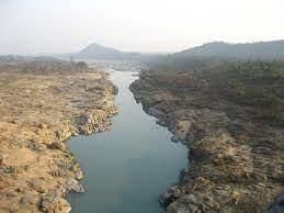
(ii) Chambal has a ____________flow.
Ans: Northern
The Chambal flows towards the north and north-east through Madhya Pradesh. For part of its course, it runs along the border between Rajasthan and Madhya Pradesh.
(iii) River ______________ divides the Plateau region into two parts.
Ans: Narmada river
The Narmada flows westwards in the long trough between the Vindhya and Satpura ranges. To the south and east of this trough, the Deccan plateau is drained by east-flowing rivers such as the Godavari and the Krishna.
(iv) ______________ Lands are also called Table Lands.
Ans: Plateau
A plateau is a flat or gently sloping area of land with a level top. Because its top is like a flat table, it is often called a tableland.
(v) Rivers _____________ and _____________ join the Arabian Sea.
Ans: Narmada and Tapti
Both the Narmada and the Tapti flow westwards and empty into the Arabian Sea. They are the main west-flowing rivers in peninsular India.
(vi) The ___________ in Karnataka is the highest waterfall in India.
Ans: Kunchikal Falls
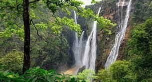
Kunchikal Falls is the highest waterfall in India, located in Karnataka. It is formed by the Varahi River and falls from a height of about 455 metres.
(vii) _______________ is the highest peak of Deccan Plateau region.
Ans: Mahabaleshwar
Mahabaleshwar is a well-known hill station in Maharashtra and is counted among the higher points of the Deccan plateau region.
(viii) The annual _________________ of Puri is very famous.
Ans: Rath Yatra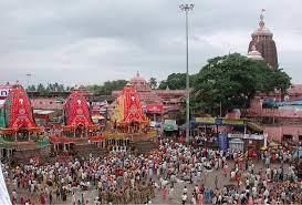
The Rath Yatra is a large chariot festival held each year at Puri in Odisha. Many people take part in the procession.
(ix) Lavani is a popular dance form of __________________.
Ans: Maharashtra
Lavani is a traditional folk dance of Maharashtra. It is known for its lively rhythm and expressive steps.
Q2: Match the following.
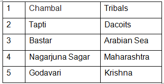
Ans: 1. Chambal - Dacoits
Long ago, the Chambal valley became known for dacoits. Some causes given are social and economic problems which led some people to take up dacoity.
2. Bastar - Tribals
Bastar is a region with many tribal communities. Important tribes here include the Gond and Abhuj Maria.
3. Tapti - Arabian Sea
The Tapti flows westwards and joins the Arabian Sea, like the Narmada.
4. Nagarjuna Sagar - Krishna
Nagarjuna Sagar Dam is built across the Krishna River. The dam lies on the border of Telangana and Andhra Pradesh.
5. Godavari - Maharashtra
The Godavari is one of India's long rivers. Its source is at Trimbakeshwar in Maharashtra.
Q3: True or False.
(i) The Central Highlands include the Malwa Plateau and the Chotanagpur Plateau.
Ans: True
Explanation: The Central Highlands of India include several plateaus, such as the Malwa plateau and the Chota Nagpur plateau. These elevated lands form part of the central highland region.
(ii) Most of India's coal is mined from the Damodar Valley.
Ans: True
Explanation: The Damodar Valley has large coalfields such as Jharia and Raniganj. Much of India's coal supply comes from these fields in the Damodar region.
(iii) Kanyakumari marks the southernmost tip of the southern plateau region.
Ans: True
Explanation: Kanyakumari is the southernmost point of the Indian mainland. It lies at the tip of peninsular India and is often called the Land's End of India.
(iv) The Plateau is not at all important for the Indian economy.
Ans: False
Explanation: The plateau regions are important for India. They provide minerals, support farming in many areas, and have forests and industries that help the economy.
(v) The rivers in the Plateau region are rain fed rivers.
Ans: True
Explanation: Many rivers on the plateau depend mainly on monsoon rains. They are seasonal and have less water in the dry summer months.
Q4: Multiple Choice Questions (MCQs).
(i) What is the shape of the southern plateaus?
(a) Triangular
(b) Round
(c) Square
(d) Rectangle
Ans: (a)
Explanation: The Deccan Plateau in southern India has a roughly triangular shape. It narrows towards the south and is edged by the Western and Eastern Ghats.
(ii) Which of these rivers do not flow through the central highlands?
(a) Son
(b) Chambal
(c) Ganga
(d) Betwa
Ans: (c)
Explanation: The Ganga flows in the northern plains, not through the central highlands. Rivers such as the Son, Chambal and Betwa pass through the central highland area.
(iii) _______ is cultivated in Maharashtra.
(a) Cotton
(b) Saffron
(c) Cardamom
(d) Basmati rice
Ans: (a)
Explanation: Cotton is a major crop grown in Maharashtra, especially in regions like Vidarbha and Marathwada.
(iv) The Andaman Islands are separated from the Nicobar Islands by the
(a) Bay of Bengal
(b) Arabian Sea
(c) Indian Sea
(d) Ten-degree channel
Ans: (d)
Explanation: The Andaman group of islands is separated from the Nicobar group by the Ten Degree Channel, a narrow stretch of sea near 10° north latitude.
Q5: Answer the following questions.
(i) What is the most common source of irrigation in the Plateau region?
Ans: Mostly prevalent in the uneven and relatively rocky plateau of peninsular India, tanks are the most popular method of irrigation in the states of Tamil Nadu, Karnataka, Andhra Pradesh and Maharashtra.
(ii) Which rivers drop down the hills to form the famous Jog Falls?
Ans: Jog Falls is created by the Sharavati dropping 253 m (830 ft), making it the third-highest waterfall in India after the Nohkalikai Falls
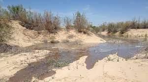
(iii) Why do rivers in the Plateau region go dry in summers while the rivers in the northern plains do not?
Ans: The rivers in the plateau are mostly rain-fed and depend on the monsoon. In summer, when there is little rain, their flow drops and some streams dry up. Rivers in the northern plains often get water from larger catchments and from melting snow in some cases, so they keep flowing longer.
(iv) List five minerals found in the Chota Nagpur Plateau.
Ans: Here are five important minerals found in the Chota Nagpur Plateau:
- Coal
- Iron ore
- Manganese
- Bauxite
- Mica
(v) Which are the main crops grown in Maharashtra?
Ans: The main crops grown in Maharashtra include:
- Rice
- Wheat
- Jowar (sorghum)
- Bajra (pearl millet)
- Sugarcane
(vi) What do people like to eat in Tamil Nadu?
Ans: People in Tamil Nadu enjoy many rice-based and South Indian dishes. Popular foods include dosa, idli, sambar and rasam. They also like curd rice and lemon rice.
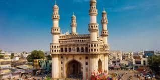
(vii) Which are the popular tourist attractions of Hyderabad?
Ans: Some popular tourist places in Hyderabad are:
- Charminar: A famous old monument in the city.
- Golconda Fort: A large ancient fort with strong walls.
- Qutb Shahi Tombs: Tombs of the old rulers with fine architecture.
- Salar Jung Museum: A big museum with many exhibits.
- Ramoji Film City: A large film studio and theme park visited by tourists.
(viii) Write a short note on the state of Jharkhand.
Ans: Jharkhand is a state in eastern India known for its rich minerals and forests. It was formed in 2000 when it was separated from Bihar. Many indigenous communities live there. Important activities in Jharkhand are:
- Mining
- Agriculture
- Manufacturing
The capital city of Jharkhand is Ranchi.
(ix) Which hill ranges surrounded the Deccan plateau?
Ans: The Deccan Plateau is surrounded by two major hill ranges:
- Western Ghats
- Eastern Ghats
These ranges run along the western and eastern edges of the plateau.
(x) Where are the Andaman and Nicobar islands located?
Ans: The Andaman and Nicobar Islands are located in the Bay of Bengal, to the south-east of the Indian mainland.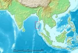
FAQs on Worksheet Solutions: The Southern Plateaus - 1
| 1. What are the main features of the Southern Plateaus that I need to know for Class 4? |  |
| 2. How do the Western Ghats and Eastern Ghats differ in the Southern Plateaus region? | |
| 3. Why is the black soil of the Deccan Plateau important for farming and settlement? | |
| 4. What rivers flow through the Southern Plateaus and why do they matter? | |
| 5. How does the climate of the Southern Plateaus affect the people living there? | |