Worksheet Solutions: Our Country India - 1

Q1: Multiple Choice Questions (MCQ).
(i) Which of these countries is not one of our neighbours?
(a) Iran
(b) Pakistan
(c) Sri Lanka
(d) Bhutan
Ans: (a)
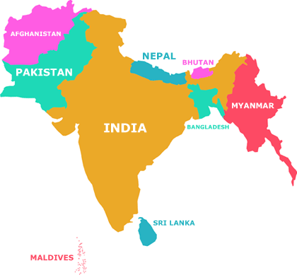
Explanation: Iran is not counted among India's neighbouring countries in the usual school-level list. The countries commonly listed as neighbours of India are Afghanistan, Bangladesh, Bhutan, China, Maldives, Myanmar, Nepal, Pakistan and Sri Lanka. These include both countries that share land borders and neighbouring island nations near India.
(ii) Kavaratti is the capital of which Union Territory?
(a) Assam
(b) Puducherry
(c) Lakshadweep
(d) Kerala
Ans: (c)
Explanation:
- Kavaratti is the capital of the Union Territory of Lakshadweep.
- Dispur is the capital of the State Assam.
- Puducherry is the capital of the Union Territory of Puducherry.
- Thiruvananthapuram is the capital of the State Kerala.
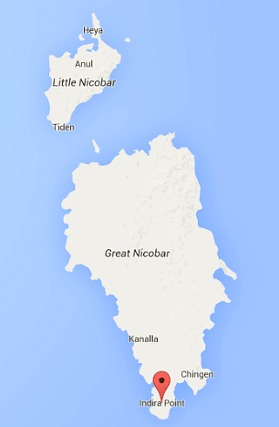
(iii) Which is the southernmost tip of India?
(a) Kerala
(b) Indira Point
(c) Puducherry
(d) New Delhi
Ans: (b)
Explanation: Indira Point is the southernmost point of India's territory. It is located on Great Nicobar Island in the Andaman and Nicobar Islands.
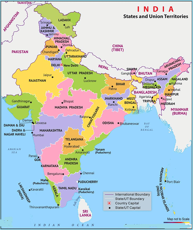
(iv) How many states are there in India?
(a) 7
(b) 36
(c) 25
(d) 28
Ans: (d)
Explanation: India is a federal union made up of 28 states and 8 union territories, a total of 36 entities. States and union territories are further divided into districts and smaller administrative units.
(v) In which state is the language Malayalam spoken by the people?
(a) Karnataka
(b) Odisha
(c) Kerala
(d) None of these
Ans: (c)
Explanation: Malayalam is the main language of the State of Kerala, which lies in the south-west of India.
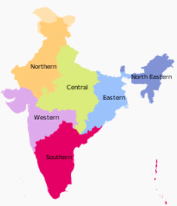
(vi) How many regions or zones are there in India?
(a) 6
(b) 5
(c) 4
(d) None of these
Ans: (a)
Explanation: India is often divided into six major geographic regions or zones for study: North, South, East, West, Central and North-East. These zones help us group states that have similar geographical features.
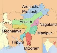
(vii) Which zone is known as the 'seven sisters' of India?
(a) North-East zone
(b) East zone
(c) West zone
(d) None of these
Ans: (a)
Explanation: The North-East zone of India is called the 'seven sisters' because it contains seven states: Arunachal Pradesh, Assam, Manipur, Meghalaya, Mizoram, Nagaland and Tripura.
(viii) Assam is known for which things?
(a) tea garden and oil fields
(b) forests
(c) Coal mines
(d) None of these
Ans: (a)
Explanation: Assam is famous for its extensive tea gardens, which produce well-known Indian tea, and for its oil fields, which are important for the country's oil production.
(ix) South zone comprises how many states?
(a) 5
(b) 4
(c) 3
(d) None of these
Ans: (a)
Explanation: The South zone of India comprises five states: Andhra Pradesh, Karnataka, Kerala, Tamil Nadu and Telangana.
(x) Which region is surrounded by seas on three sides?
(a) South zone
(b) West zone
(c) North zone
(d) None of these
Ans: (a)
Explanation: The South zone is surrounded by water on three sides: the Arabian Sea to the west, the Indian Ocean to the south and the Bay of Bengal to the east.
(xi) The highest mountain range in the world, the Himalayas, lies in which zone?
(a) North zone
(b) East zone
(c) South zone
(d) None of these
Ans: (a)
Explanation: The Himalayas, the highest mountain range in the world, lie in the northern part of India and therefore belong to the North zone.
(xii) Which zone is famous for wildlife sanctuaries and national parks?
(a) West zone
(b) East zone
(c) Central zone
(d) None of these
Ans: (a)
Explanation: The West zone of India includes many important wildlife sanctuaries and national parks. These areas protect a wide variety of animals and plants and are well known for their biodiversity.
(xiii) The South zone is famous for
(a) all of these
(b) silk and spices
(c) Cold mines
(d) None of these
Ans: (b)
Explanation: The South zone is particularly known for producing silk and a wide variety of spices. These are important local products and attract trade.
(xiv) Which of the following is not a neighbouring country of India?
(a) Indonesia
(b) Pakistan
(c) Bangladesh
(d) None of these
Ans: (a)
Explanation: Indonesia is not a direct neighbour of India by land. Pakistan and Bangladesh share land borders with India. Indonesia is an island nation farther to the east and does not border India directly.
(x) How many union territories are there in India?
(a) 7
(b) 6
(c) 5
(d) None of these
Ans: (d)
Explanation: As of the current official counts used in school geography, India has 8 union territories. Since 8 is not one of the numeric options given, the correct choice from these options is None of these.
Q2: The underlined word in each sentence is incorrect. Write the correct word.
(i) The northern boundary of India is protected by the Alps.
Ans: Himalayas.
- The Himalayas are the young fold mountains that stretch across India's northern border from the Indus to the Brahmaputra.
- The frontier with China runs along these ranges and continues from the tri-junction with Afghanistan in the west to the tri-junction with Myanmar (Burma) in the east.
- (The Alps are a mountain range in Europe, not India.)
(ii) Maharashtra is the largest state of India.
Ans: Rajasthan.
- Rajasthan is the largest state in India by area, covering about 342,239 km2.
- Maharashtra is the third largest state by area, covering about 307,713 km2.
(iii) India is in Africa.
Ans: Asia.
- India is part of the continent of Asia, in the region called South Asia or the Indian subcontinent.
- India is the second-largest country in Asia by population and one of the largest by area.
(iv) The capital of Telangana is Amaravati.
Ans: Hyderabad.
- The capital of Telangana is Hyderabad.
- Amaravati is the capital of the state of Andhra Pradesh.
(v) Silvassa is the capital of both Punjab and Haryana.
Ans: Chandigarh.
- Chandigarh is the capital of both Punjab and Haryana.
- Silvassa is the capital of the Union Territory of Dadra and Nagar Haveli.
Q3: Answer these questions.
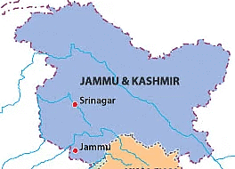
(i) Which Union Territory has two capitals?
Ans: Jammu and Kashmir is a Union Territory that has two capitals: Srinagar (summer capital) and Jammu (winter capital).
(ii) Write the names of the water bodies that surround India.
Ans: India is surrounded by the Bay of Bengal to the east, the Arabian Sea to the west and the Indian Ocean to the south.
(iii) What are the five physical divisions of India?
Ans: India is commonly divided into five major physical units. They are:
- The Great Mountains of the north (Himalayas)
- The North Indian Plain
- The Peninsular Plateau
- The Coastal Plains
- The Islands (Andaman & Nicobar and Lakshadweep)
(iv) How will you show that you love your country?
Ans:
- By keeping the country clean and not littering public places.
- By being an active and responsible citizen, following rules and helping others.
- By respecting national symbols and taking part in community activities that improve the nation.
(v) Find out the following about any one neighbouring country of India:
(a) its capital
(b) the language spoken
(c) a famous monument
(d) a popular festival celebrated
Ans: Information about Nepal:
(a) Capital: Kathmandu
(b) Language spoken: Nepali
(c) Famous monument: Boudhanath Stupa (a well-known Buddhist site)
(d) Popular festival: Dashain (a major Hindu festival celebrated widely in Nepal)
Q4: Think and answer.
Why does the capital of Jammu & Kashmir shift from Srinagar to Jammu in winter?
Ans:
- This practice of having two capitals began over a century ago, so the administration could move away from the harsh winter weather of Srinagar.
- Srinagar is centrally located for much of the territory and is suitable for administration during milder months.
- In winter, heavy snow, landslides and blocked highways can make travel and trade difficult around Srinagar.
- To keep government work, trade and services running smoothly, the administration shifts to Jammu during the winter months.
Q5: Cross Puzzle.
Fill in the word puzzle with the capitals of the given states and Union Territory.
Across
4. Jharkhand
5. Chhattisgarh
6. Andaman and Nicobar Islands
Down
1. Tripura
2. Karnataka
3. Assam
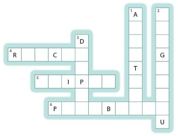
Ans:
Across
4. Ranchi
5. Raipur
6. Port Blair
Down
1. Agartala
2. Bengaluru
3. Dispur
FAQs on Worksheet Solutions: Our Country India - 1
| 1. What are the main features of India that make it a unique country? |  |
| 2. How many states and union territories does India have, and what's the difference between them? | |
| 3. What are the major geographical features of India that students need to know? | |
| 4. Why is India's location in South Asia important for understanding its history and culture? | |
| 5. What should I remember about India's capital city and other important cities for Class 4 Social Studies? | |