UPSC Exam > UPSC Notes > Geography CSE > Mind Map: Deccan Plateau
Mind Map: Deccan Plateau

The document Mind Map: Deccan Plateau is a part of the UPSC Course Geography for UPSC CSE.
All you need of UPSC at this link: UPSC
FAQs on Mind Map: Deccan Plateau
| 1. What is the geographic location of the Deccan Plateau? |  |
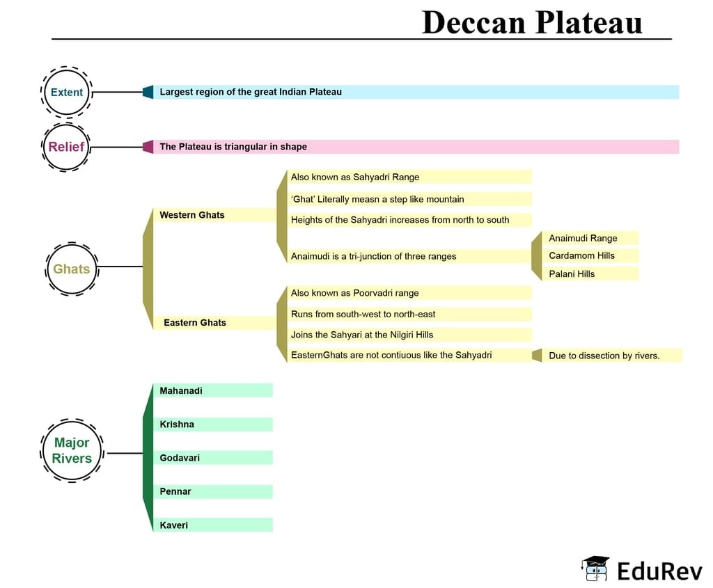
Ans. The Deccan Plateau is located in the southern part of India, covering a major portion of the peninsular region.
| 2. What is the average elevation of the Deccan Plateau? | |
Ans. The average elevation of the Deccan Plateau is around 600 to 900 meters above sea level.
| 3. What are the major rivers that flow through the Deccan Plateau? | |
Ans. The major rivers that flow through the Deccan Plateau include the Godavari, Krishna, and Kaveri rivers, among others.
| 4. What is the climate like in the Deccan Plateau? | |
Ans. The climate in the Deccan Plateau is predominantly hot and dry, with semi-arid conditions in many areas. It experiences distinct seasons with hot summers and relatively cooler winters.
| 5. What are some of the significant historical and cultural landmarks found on the Deccan Plateau? | |
Ans. The Deccan Plateau is home to several historical and cultural landmarks, including ancient rock-cut caves like Ajanta and Ellora, UNESCO World Heritage Sites like Hampi and Pattadakal, and iconic forts like Golconda Fort in Hyderabad.
About this Document

1.3K Views

4.79/5 Rating

Apr 19, 2026 Last updated
Related Exams
Document Description: Mind Map: Deccan Plateau for UPSC 2026 is part of Geography for UPSC CSE preparation. The notes and questions for Mind Map: Deccan Plateau have been prepared according to the UPSC exam syllabus. Information about Mind Map: Deccan Plateau covers topics like and Mind Map: Deccan Plateau Example, for UPSC 2026 Exam. Find important definitions, questions, notes, meanings, examples, exercises and tests below for Mind Map: Deccan Plateau.
Introduction of Mind Map: Deccan Plateau in English is available as part of our Geography for UPSC CSE for UPSC & Mind Map: Deccan Plateau in Hindi for Geography for UPSC CSE course. Download more important topics related with notes, lectures and mock test series for UPSC Exam by signing up for free. UPSC: Mind Map: Deccan Plateau
Description
Mind Map: Deccan Plateau of Geography provides you one-page visual summary of the chapter covering all the important topics. Download the PDF from EduRev.
Information about Mind Map: Deccan Plateau
In this doc you can find the meaning of Mind Map: Deccan Plateau defined & explained in the simplest way possible. Besides explaining types of Mind Map: Deccan Plateau theory, EduRev gives you an ample number of questions to practice Mind Map: Deccan Plateau tests, examples and also practice UPSC tests


Related Searches
past year papers, Semester Notes, video lectures, pdf , Extra Questions, Summary, Mind Map: Deccan Plateau, Objective type Questions, study material, Viva Questions, Important questions, mock tests for examination, Previous Year Questions with Solutions, Sample Paper, Free, Exam, Mind Map: Deccan Plateau, practice quizzes, MCQs, shortcuts and tricks, Mind Map: Deccan Plateau, ppt;