UPSC Exam > UPSC Notes > Geography CSE > Mind Map: India (Size & Location)
Mind Map: India (Size & Location)

The document Mind Map: India (Size & Location) is a part of the UPSC Course Geography for UPSC CSE.
All you need of UPSC at this link: UPSC
FAQs on Mind Map: India (Size & Location)
| 1. What are the exact geographical coordinates and boundaries of India? |  |
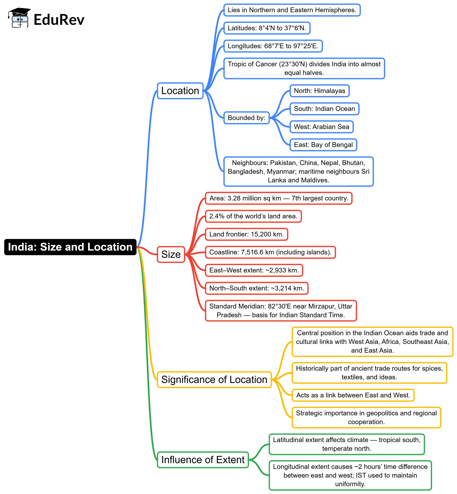
Ans. India extends from 8°4' N to 35°6' N latitude and 68°7' E to 97°25' E longitude, covering approximately 3.28 million square kilometres. The country is bordered by the Arabian Sea, Bay of Bengal, and Indian Ocean, with land boundaries shared by Pakistan, Afghanistan, China, Nepal, Bhutan, Bangladesh, and Myanmar. These precise geographical limits define India's territorial sovereignty and maritime exclusive economic zone.
| 2. How does India's size compare to other countries in Asia and the world? | |
Ans. India ranks as the seventh-largest country globally and the second-largest in Asia after Russia. Covering roughly 2.4% of Earth's total land area while supporting over 17% of the world's population, India demonstrates significant population density relative to its territorial expanse. This comparison highlights India's geopolitical and demographic importance within continental and global frameworks.
| 3. Why is India's north-south and east-west extent important for understanding its geography? | |
Ans. India's north-south extent of approximately 3,214 kilometres and east-west span of roughly 2,933 kilometres create diverse climatic zones, vegetation patterns, and regional characteristics. This vast dimensional range produces varied physical features-from the Himalayan mountain system to tropical coasts-influencing agriculture, settlement patterns, and economic activities across different geographical regions of the country.
| 4. What major geographical features define India's location within the Indian subcontinent? | |
Ans. The Himalayas form India's northern boundary, while the Western and Eastern Ghats define peninsular edges, and the Thar Desert marks the northwestern frontier. These distinctive landforms, combined with India's position on the Indian plate and its coastline spanning over 7,500 kilometres, establish the nation's unique geographical identity. Refer to mind maps to visualise these critical physical boundaries and regional demarcations clearly.
| 5. How does India's strategic location influence its historical and contemporary significance? | |
Ans. Positioned between the Arabian Sea and Bay of Bengal, India commands crucial maritime trade routes connecting Europe, Africa, and Southeast Asia. This central location fostered ancient trade networks, cultural exchanges, and colonial interests. Today, it strengthens India's role in regional geopolitics, naval presence, and economic partnerships, making geographical positioning fundamental to national security and international relations strategy.
About this Document

5.9K Views

4.79/5 Rating

Apr 19, 2026 Last updated
Related Exams
Document Description: Mind Map: India (Size & Location) for UPSC 2026 is part of Geography for UPSC CSE preparation. The notes and questions for Mind Map: India (Size & Location) have been prepared according to the UPSC exam syllabus. Information about Mind Map: India (Size & Location) covers topics like and Mind Map: India (Size & Location) Example, for UPSC 2026 Exam. Find important definitions, questions, notes, meanings, examples, exercises and tests below for Mind Map: India (Size & Location).
Introduction of Mind Map: India (Size & Location) in English is available as part of our Geography for UPSC CSE for UPSC & Mind Map: India (Size & Location) in Hindi for Geography for UPSC CSE course. Download more important topics related with notes, lectures and mock test series for UPSC Exam by signing up for free. UPSC: Mind Map: India (Size & Location)
Description
Mind Map: India (Size & Location) of Geography provides you one-page visual summary of the chapter covering all the important topics. Download the PDF from EduRev.
Information about Mind Map: India (Size & Location)
In this doc you can find the meaning of Mind Map: India (Size & Location) defined & explained in the simplest way possible. Besides explaining types of Mind Map: India (Size & Location) theory, EduRev gives you an ample number of questions to practice Mind Map: India (Size & Location) tests, examples and also practice UPSC tests


Related Searches
Viva Questions, Objective type Questions, shortcuts and tricks, Semester Notes, past year papers, mock tests for examination, Mind Map: India (Size & Location), Extra Questions, Mind Map: India (Size & Location), Sample Paper, Important questions, Exam, study material, video lectures, MCQs, Free, pdf , Summary, practice quizzes, Previous Year Questions with Solutions, ppt, Mind Map: India (Size & Location);