CBSE Class 9 > Class 9 Notes > Social Studies (SST) > Mind Map: Physical Features of India
Mind Map: Physical Features of India

The document Mind Map: Physical Features of India is a part of the Class 9 Course Social Studies (SST) Class 9.
All you need of Class 9 at this link: Class 9
FAQs on Mind Map: Physical Features of India
| 1. What are the major mountain ranges in India and how do they affect the climate? |  |
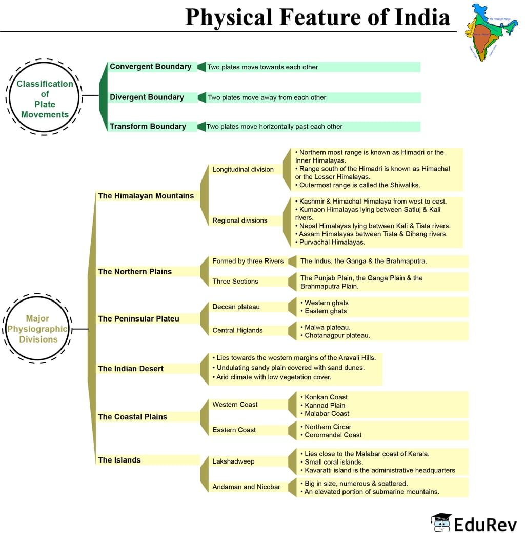
Ans. India's principal mountain systems-the Himalayas, Western Ghats, and Eastern Ghats-significantly influence rainfall, temperature, and wind patterns across regions. The Himalayas block cold Arctic winds, protecting the plains, while the Western Ghats force monsoon winds upward, creating heavy precipitation on windward slopes. These physical features shape India's diverse climate zones and agricultural productivity.
| 2. How do the Northern Plains differ from the Deccan Plateau in terms of geography? | |
Ans. The Northern Plains are flat, alluvial lowlands formed by river deposits, ideal for agriculture, while the Deccan Plateau is an elevated, triangular landmass with harder rock formations and gentler slopes. The plains receive more rainfall and support denser populations, whereas the plateau has varied terrain with distinct ridges and valleys. These geographical characteristics determine settlement patterns and land use.
| 3. What role do India's major rivers play in shaping its physical landscape? | |
Ans. India's principal rivers-the Ganges, Brahmaputra, Indus, and Godavari-carve valleys, deposit fertile silt on floodplains, and create deltas that support agriculture and human settlement. River systems determine water availability, influence soil composition, and create natural boundaries between regions. Understanding river geography is essential for CBSE Class 9 Social Studies exams.
| 4. Why is the Thar Desert located in northwestern India and how does it impact the region? | |
Ans. The Thar Desert occupies northwestern India due to its position in the rain shadow of the Aravalli Mountains, which block monsoon moisture. This arid region experiences low precipitation, sparse vegetation, and extreme temperatures, limiting agricultural development. Desert geography influences settlement density, water scarcity challenges, and the lifestyle of inhabitants in Rajasthan and Gujarat.
| 5. What are the main coastal features of India and why are they important for human activities? | |
Ans. India's extensive coastline includes peninsulas, bays, and coastal plains forming natural harbours and fishing grounds. The Arabian Sea and Bay of Bengal coasts support major ports, maritime trade, and fishing industries. Coastal physical features facilitate commerce, tourism, and transportation, making them crucial for economic development and understanding India's geographical significance.
About this Document

2.8K Views

4.91/5 Rating

Apr 18, 2026 Last updated
Document Description: Mind Map: Physical Features of India for Class 9 2026 is part of Social Studies (SST) Class 9 preparation. The notes and questions for Mind Map: Physical Features of India have been prepared according to the Class 9 exam syllabus. Information about Mind Map: Physical Features of India covers topics like and Mind Map: Physical Features of India Example, for Class 9 2026 Exam. Find important definitions, questions, notes, meanings, examples, exercises and tests below for Mind Map: Physical Features of India.
Introduction of Mind Map: Physical Features of India in English is available as part of our Social Studies (SST) Class 9 for Class 9 & Mind Map: Physical Features of India in Hindi for Social Studies (SST) Class 9 course. Download more important topics related with notes, lectures and mock test series for Class 9 Exam by signing up for free. Class 9: Mind Map: Physical Features of India
Description
Mind Map: Physical Features of India of SST provides you one-page visual summary of the chapter covering all the important topics. Download the PDF from EduRev.
Information about Mind Map: Physical Features of India
In this doc you can find the meaning of Mind Map: Physical Features of India defined & explained in the simplest way possible. Besides explaining types of Mind Map: Physical Features of India theory, EduRev gives you an ample number of questions to practice Mind Map: Physical Features of India tests, examples and also practice Class 9 tests


Related Searches
ppt, Important questions, Mind Map: Physical Features of India, Objective type Questions, Exam, Mind Map: Physical Features of India, Free, Viva Questions, practice quizzes, pdf , mock tests for examination, shortcuts and tricks, Extra Questions, past year papers, Sample Paper, Semester Notes, study material, MCQs, video lectures, Mind Map: Physical Features of India, Previous Year Questions with Solutions, Summary;